Pretty easy to find. Follow directions to reach the great cup-and-ring marked Haystack Rock, then follow the footpath west and drop down the slope, crossing the stream of the Backstone Beck below you, the up the steepish slope and turn sharp left when you hit the footpath before the top of this slope. Walk onto the moor! You’ll walk right past the cup-and-ring marked ‘carving 283’ on this path, then the ruinous Backstone Circle a bit further along (50 yds to your right), but keep walking for another 100 yards until you see a large boulder a few yeards to the left of the footpath. That’s it!
Archaeology & History
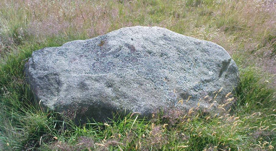
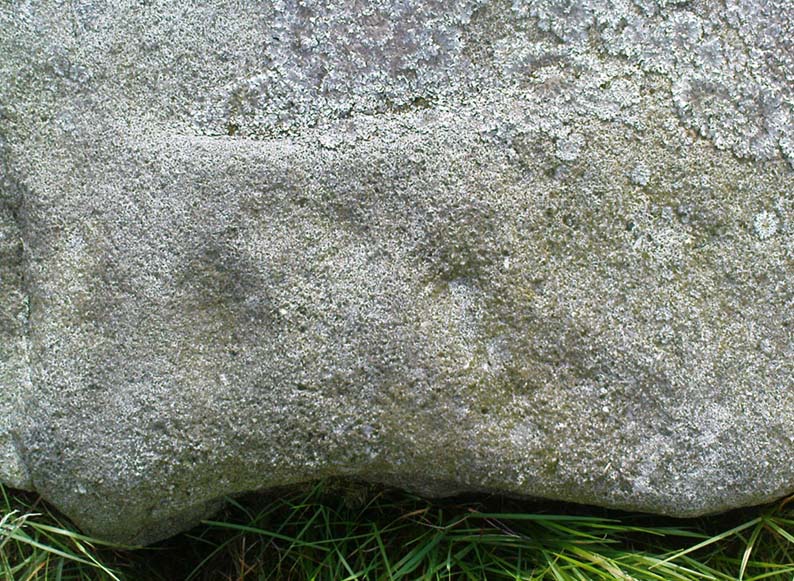
I first came across this as a kid, sometime in my early to mid-teens, pottering about, looking at any old rock that caught my eye. And this one isn’t hard to miss really. One of the best memories I’ve got of this stone was when a bunch of us came walkabout up here, sometime in the autumn, when the heavens poured all day long to saturation-point — even for those in all their protective gear, such good as it was in the late ’80s to early ’90s. There started out a fair bunch of us—between 20-30 folk—with numbers dwindling sharply when we reached the Apostles. But this stone was visited way before that! Along with Bob Trubshaw, Graeme Chappell, Kaledon Naddair, Edna Whelan and a troop of other mad-folk, we stopped for a while to consider this old rock, with only three cups really visible that day. The others (those cited by the archaeo’s) weren’t picked out, as I remember. But She was pissing-it-down and the wind was really giving-it-some, so we didn’t stop here for long! We all agreed though: it was a nice, worn cup-marked stone.
Gill Head rock carvingGill Head carving (after Hedges 1986)
John Hedges and the Ilkley Archaeology bunch had cited it as ‘cup-and-ring’ in their fine work — the first time this old carving had been in print since it was first etched! A few years later when Messrs Boughey & Vickerman (2003) checked it for their survey, no new features had been noted and they just copied Hedge’s earlier notes. Indeed, it’s just a large boulder with a few archetypal cupmarks on it when it first greets the eyes. Nowt special—and with no companions either.
This is another one mainly for the mad-folk and purists amongst us.
References:
Boughey, Keith & Vickerman, E.A., Prehistoric Rock Art of the West Riding, WYAS 2003.
Hedges, John (ed.), The Carved Rocks on Rombald’s Moor, WYMCC: Wakefield 1986.
Easy enough this one. Take the B4066 west of Woodchester past the Boundary Court and over the cattle grid for 100 yards or so. Note the fence up the slope to your left (south) up the field here head for the triangulation pillar. Once there keep walking for about another 100 yards. You can’t miss it!
Archaeology & History
The mad craniologist John Thurnam (1810-73) was one of several old-school fellas who helped to excavate this grand site on one occasion. Thinking that human sacrifice lay behind virtually all of the burial mounds, Thurnam was part of the Cotteswold Field Club group who investigated the place; and, because of his intellectual capacity in cranial investigations, was listened to by the budding archaeo’s of the day cos he was cleverer than them (hero worshipping). A bit naive of them, but such is the way of some folk! Yet their early account of this site (devoid of Thurnam’s weird notions) is quite invaluable, even today. Described in an address by their President in the Proceedings in 1865, the article tells:
“The Club met at Stroud. The principal work of the day was the opening of a ‘barrow’ on Bown Hill…which had formed the subject of discussion towards the end of the previous season when, the period of the year being too far advanced, the work of exploration was deferred. Workmen had been employed under Dr Paine and Dr Witchell on the two previous days; but beyond the discovery of the entrance to the sepulchral chambers no great progress had been made in the excavation of the mound which, from its size and solidity, proved to be a very laborious operation. In order, therefore, to expedite matters, a strong force of labourers, 22 in number, had been employed from an early hour on the day of the meeting. The mound, which measured about 60 yards in length by 17 in extreme width, was seen to be constructed of angular masses of stone, heaped together without any order or regularity, amongst which were scattered blocks of considerable size and weight.
“The excavators had opened a trench about 100 feet in length, in a direction due east and west by compass. The western extremity was the broadest, the mound gradually diminishing in width to the opposite end. The workmen had struck upon the entrance which, when exposed, showed a chamber formed of five large, unhewn stones, two on each side and one placed transversely, the dimensions of which were 4 feet in width by 8 feet 6 inches in length. There was no covering stone, but the entrance was flanked on either side by a wall of dry masonry, very neatly fitted, forming a segment of a circle, which, if completed, would have enclosed a well-like chamber in front of the entrance to the tumulus. This wall had been abruptly broken off; but there were amongst those present some who thought they detected signs of it having been at one time continuous. It was evident that the whole structure had been thoroughly ransacked and broken up by former explorers; and so completely had the work of devestation been accomplished that hardly one stone was left upon another. The chambers, with the one exception already noted, had been entirely demolished, and but a few bones scattered throughout the whole tumulus remained, all more or less in a fragmentary condition. These fragments comprised one fully developed frontal bone, male; portions of two male lower jaws, and portions of two female skulls; several thigh bones, and bones of the leg and foot, including the remains of children, but all much broken. There were found the remains of six indiiduals at the least, viz, two men, two women and two children, the latter between six and eight years of age. There were several bones of cattle and calves; teeth of horse and ox; a portion of the bones of the foreleg of a dog; several boar’s teeth, tusks and grinders, and parts of jaw bones; a bone ‘scoop’, formed of a shank bone of a horse; and a large quantity of a black unctuous substance, having the appearance of wood or animal charcoal; but no burnt bones. A small portion of a small flint flake was detected in the black paste. Besides the organic remains above enumerated, some pieces of rude pottery were found, which, with a Roman brass coin of the Emperor Germanicus, complete the list of objects yielded…”
Some of the remains found in Bown Hill’s long barrow
A few years later George Witts’ (1883) described the tomb but added little to the description above. When Crawford (1925) came here in December, 1920, the greatest height of the tomb was just ten feet and he described that “the extreme eastern end has been destroyed by quarrying.” He could clearly discern various trenches and the remains of previous excavations around the tomb, but added little further, apart from an important geomantic ingredient:
“It stands near the highest point (763 feet) of the hill and commands a magnificent view. South eastwards can be seen the Berkshire Downs (probably the White Horse Hill and Wayland’s Smithy); northwards May Hill and the Malvern Hills are visible; in the western distance are the Brecknock Beacons and the Black Mountains…”
Crawford later received further notes about the 1863 dig at Bown Hill from the son of Dr Paine that had been written following the original excavation. Although they convey little extra from the above account, I’ll add the notes to this entry in the near future.
References:
Crawford, O.G.S., The Long Barrows of the Cotswolds, John Bellows: Gloucester 1925.
Darvill, Timothy, Prehistoric Gloucestershire, Alan Sutton: Gloucester 1987.
Grinsell, L.V., The Ancient Burial Mounds of England, Methuen: London 1936.
Guide, W.V., ‘Address to the Cotteswold Naturalists’ Field Club,’ in Proceedings of the Cotteswold Naturalists’ Field Club, volume 3, 1865.
Witts, George, Archaeological Handbook of Gloucestershire, G. Norman: Cheltenham 1883.
This stone stands on the south-side of the B4450 just north of the crossroads, halfway between Churchill and Chipping Norton. Generally troublesome to see at first as it tends to get hidden in the hedgerow, so you may need to furrow into the but shrubbery to get to it, but it’s not too difficult to locate with a bit of patience.
Archaeology & History
This small standing stone seems to have been described for the first time in O.G.S. Crawford’s (1925) fine survey of the regions prehistoric remains following a letter he received from a local man, Mr A.D. Passmore, who first drew it to the attention of archaeologists. Crawford told:
“This stone is a little over a mile southwest of Chipping Norton station. It stands in the hedge on the northwest side of the road and is about four feet high… Nothing more is known about it, but it seems not unlikely that it may be of considerable antiquity.”
A few years later Leslie Grinsell (1936) mentioned it in his equally fine survey of prehistoric English tombs and associated remains, describing here, “a large stone which may be the remains of a megalithic monument.” Tom Wilson then illustrated it in our crappy little Old Stones of Rollright (1999) work (which really needs updating and expanding). It’s a cute little stone and may have once served as a companion to a prehistoric tomb as there are many others nearby. It is also quite close to one of the local boundary lines and, p’raps, might once have served as a marker hereabouts. We might never know…
References:
Bennett, Paul & Wilson, Tom, The Old Stones of Rollright and District, Cockley: London 1999.
Crawford, O.G.S., The Long Barrows of the Cotswolds, John Bellows: Gloucester 1925.
Grinsell, Leslie V., The Ancient Burial Mounds of England, Methuen: London 1936.
Seemingly not visible anymore, but directions given by a Miss N. Hutchinson in the early 1960s worked for me and Dave Pendleton when we checked this out at the end of our teens. We had to look around till we found it, based on the following directions. The carving was found “on top of a low dry wall on Esholt Lane, Esholt…on the stretch of road from the junction of Gill Beck with the River Aire to the stone-built barn on the left-side of the road, that is, going towards Esholt.”
Archaeology & History
Esholt Lane Carving, Bradford
First described by Miss Hutchinson in a letter she sent to Sydney Jackson (1964), editor of Bradford Archaeology group newsletter. When we first found this small carving (not far from where we grew up) we were at the end of our teens, and followed the directions cited in the Cartwright Hall Archaeology Group Bulletin (see above). The carved design was typical of the primary arcs found in many of the Baildon Moor cup-and-ring carvings a bit further up the hill, but with two other small faint cup-markings on it. According to Boughey & Vickerman (2003), the carving’s now been hidden in a section of walling that’s been rebuilt. The drawing here is from one of my unpublished notebooks. (1984)
References:
Bennett, Paul, Ramblings of Archaeological Remnants in West Yorkshire, unpublished: Shipley 1984.
Boughey, Keith & Vickerman, E.A., Prehistoric Rock Art of the West Riding, WYAS 2003.
Jackson, Sydney, ‘Cup-Marked Rock – Esholt Discovery,’ in Bradford Cartwright Hall Archaeology Group Bulletin, 9:4, 1964.
Along the B6265 Pateley Bridge-Grassington road, roughly halfway between Stump Cross Caverns and the turn down to Skyreholme and Appletreewick (New Lane) is a dirt-track on your right-hand side called Black Hill Road. Walk along here for a few hundred yards till y’ reach the gate on the right. A track meanders downhill to the psilocybin-rich pastures of Nussey Green. Several hundred yards down, to the right-hand side of the track, we find this stone and its several nearby companions. Look around – you’ll find it!
Archaeology & History
I like this carving — I think because of the initial impression it gave, which was one of numeracy and linearity: an unusual quality for a cup-and-ring stone. Those of you with an astronomical or mathematical slant may have a similar response.
Line Stone Carving, Skyreholme
The stone was first described in one of Stuart Feather’s (1964) many short notices. Its existence then remained dormant until it was eventually listed in Boughey & Vickerman’s (2003) survey on the West Riding rock-art, where they catalogued it as ‘stone no.401.’ The carving comprises of two parallel lines—one quite deep—with cup-marks at either end; one of the lines having another 2 cups along it. A third line at an angle has one or two cups along it aswell. Several other single cups scatter the rock (forgive my crap drawing of it!).
References:
Boughey, Keith & Vickerman, E.A., Prehistoric Rock Art of the West Riding, WYAS 2003.
Feather, Stuart, ‘Appletreewick (WR),’ in Yorkshire Archaeology Journal 41, 1964.
Various ways here, but for the sake of newcomers I’d say it was best following directions from Burnsall. From here, take the Appletreewick road thru the village, past the left turn a few hundred yards along, and another 500 yards or so there’s a split in the road: take the one on your right! Follow this up, keeping right (don’t turn into Perceval Hall, tempting though it may be!) and park-up where the road turns into a track. Walk up the track, past the haunted junction, bearing left uphill up Black Hill Road until you reach the very peak of the track where, in the walling on your left, you’ll see this big boulder. If you can’t see it, you’re bloody close!
Archaeology & History
This is at the very peak of Black Hill Road, with excellent views of Simon’s Seat climbing to the immediate south, the prominent and rounded Nursery Knot Hill immediately north, and grand views to peaks east and west. It is very likely this position had something to do with it being deemed worthy of relevance. The rock itself defines a point along the old boundary line.
Skyreholme Wall Boundary carving
One peculiarity on this boulder is the deep cup-mark with a strange ‘lip’ to it, which has been mentioned by others in the past. This is surrounded by at least five others cups — not dissimilar to some of the ‘rosary-designs’ of cup-and-rings further north.
The rock art student’s Boughey & Vickerman’s (2003) drawing of this design is pretty accurate — where they call it stone 413 — though it doesn’t actually give this carving the justice it deserves. They also erroneously tell that some of the cups here are doubtful.
Check it out for y’self. This is an excellent stone for cup-and-ring lovers! (with plenty of other sites scattered about all round here)
References:
Boughey, Keith & Vickerman, E.A., Prehistoric Rock Art of the West Riding, WYAS 2003.
On the opposite side of the road (B6265) from Airedale General Hospital, Steeton, you’ll notice a footpath going up the field into some woods. Go up here. Once you come out the top of the woods, follow the dodgy path on your right (west) along the rocky edges for 250 yards, following the edges of the field walling. You’ll eventually reach the field with lots of rocks in it. It’s the field before this one, close to the walling. Look around!
Archaeology & History
I’ve been a little cautious about putting this carving on TNA simply because it seems to be an isolated example and was a little unsure about its veracity. If I’d have found the stone on the edges of Ilkley Moor, Rivock Edge, or the heights above Askwith, I wouldn’t have hesitated. The fact that no other carvings occur nearby has been my main trouble. But I suppose if the carving turns out to be nowt of the sort, I can discard it at a future date and, of course, make sure that a lot of other cup-and-ring stones are disregarded at the same time (there are a number of other designs much less defined than this one which have been okayed by archaeo’s who’ve been into this subject for much shorter periods of time than myself). But less of the waffle!
Currer Wood Carving, Steeton
When we first found this, in April 2009, I was out looking for the remains of an old well (called Jane Well, a few hundred yards west of here). The heaven’s opened and I ended up in the woodland and then found the field full of large rocks, some seemingly used by man in more recent centuries, atop of the woods, and so had to check them out! But this was one of the first stones we found.
Currer Woods Stone
The rock itself, as the photo shows, appears to have had one end of it split or broken off (not unlike one edge of the Hanging Stones, Ilkley Moor) at some time in the past, intruding on the arc, or line, beneath which are two distinct ‘cups’. A possible third cup-marking and other linear aspects seem apparent, with the design giving the distinct impression of a face. I keep meaning to go back and get a rubbing of the carving, but aint got round to it yet. When (if!) I gerrit done, I’ll add it onto this profile.
And although there are said to be no other prehistoric remains close to this old carving, the fields a coupla hundred yards west used to be called the Barrow Fields, where tombs were once found; and a little further along the same geological ridge atop of the excellent Kirk rocks, possible cup-markings scatter the edges of two sections — but they’re a little dubious; then there’s the Dragon Stone and associated cup-marked stone not far away. In the adjacent woods are the remains of old walling, but I’ve not found other carvings hereabouts. However, the rule tends to be: “where there’s one, there are more!”
This takes a bitta getting to and won’t really be worthwhile unless you’re a rock-art nut! I s’ppose if you’re looking at the other decent cup-and-ring stones on the summit of Addlebrough, it might be worth looking at. In which case, walk a coupla hundred yards southeast towards where the walling meets and climb over. The walk a little further in the same direction and once you’ve gone less than 100 yards, look around. You can’t really miss it if you potter about.
Archaeology & History
Single cup-marked stone (photo by Richard Stroud)
This possible single cup-marked stone appears to have been discovered before me ‘n Richard Stroud got to the spot, by none other than Stan Beckensall himself — or at least it’s in Stan’s Prehistoric Rock Art of County Durham, Swaledale and Wensleydale book, where he describes it as it only can be done: “a single possible cup-marked stone…SSE of the summit cairn”, which is where you find this. (Another single cup-marked stone found nearby by Barbara Brown aint the same one as this.)
References:
Beckensall, S. & Laurie, T., Prehistoric Rock Art of County Durham, Swaledale and Wensleydale, County Durham Books 1998.
Follow the footpath running from the Rivock TV mast northwest, where it cuts diagonally across the field, heading towards the drystone wall. About 200 yards before the walling – stop! It’s just to your right-hand side, very close by!
Archaeology & History
First discovered in July 2009 when Keighley volunteer, Michala Potts of Bracken Bank, did further ramblings amidst the long grasses hereabouts. Its name comes from the fact that it’s found just next to the footpath that cuts across Rough Holden from the TV mast beneath Rivock. The carving’s a very simple plain design, as the photos show, with just three faded cup-markings etched onto the stones northeast face.
Close-up of cup-markings
This stone aint too far from the cup-marked Dump Stone and the nearby Rough Holden design, but all across the Holden Rough grasslands are the faded remains of old pit-workings. It makes you wonder just how many other carvings once existed across this flatland. The fact that this and the other ones nearby still remain is damn fortunate!
Going thru Pitlochry town, turn up the A924 road for about a mile till you hit the Moulin Inn on your left-hand side. Just past here, take the road left and continue for 2-300 yards until the stone in the field stands out on your right-hands side. Y’ can’t really miss it!
Archaeology & History
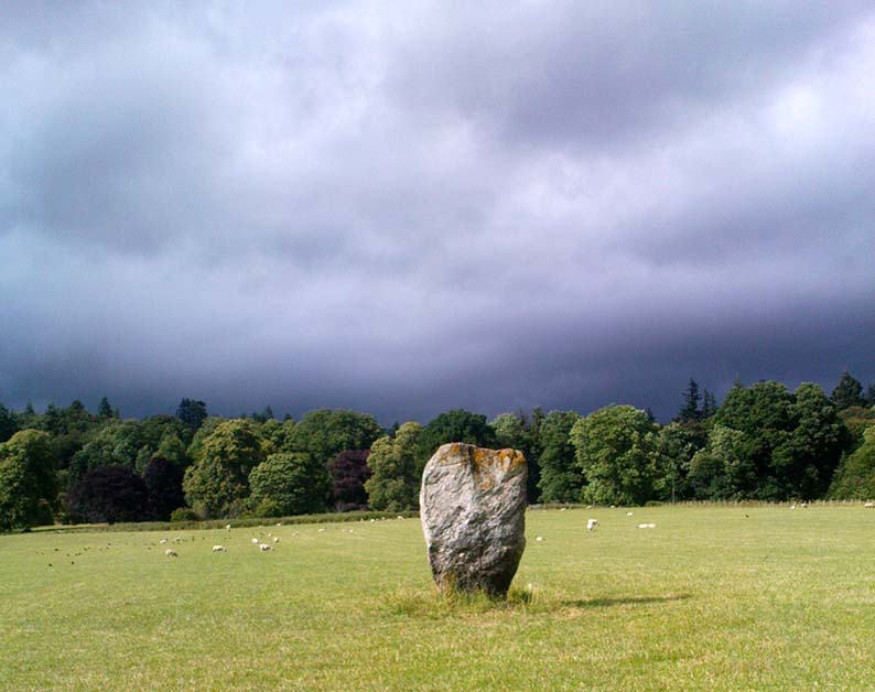
I should mebbe have this site entered as a ‘stone circle’ and not just an old monolith, as numerous other standing stones were in close attendant not too long ago and it was said to have been a circle. Certainly when the great Fred Coles (1908) talked about this place, he
“was informed by the tenant, Mr Reid…that many years ago, in his grandfather’s time, “there were several more stones standing”, all smaller than this monolith and that, upon the orders given by Mrs Grant Ferguson of Baledmund, some of these were saved from total demolition, and are supposed to be lying half-buried in the field to this day.”
…and here’s the big man close-up
Though I imagine these remnants have now been removed. Aerial images, when conditions are just right, might prove fruitful here.
But the solitary stone still standing here is quite a big fella. Heavily encrusted with quartz and more than 7 feet tall, it’s a nice fat chunky thing, with its lower half being somewhat slimmer than the top. Well worth having a look at!
Folklore
Once an old moot site, folklore also tells that an old market was once held here (there was some other folklore I had of this place, but can’t for the life of me find it at the moment!).


")
")