Cross (destroyed): OS Grid Reference – SE 3071 3463
Archaeology & History
In James Wardell’s (1890) work on Kirkstall Abbey he describes several of the long lost stone crosses that used to exist in the area. This one,
“formerly stood by the road side at the south end of Sheepscar Bridge, in Leeds.”
The cross had already been destroyed by the time the Ordnance Survey lads explored the area in the 1840s, as there’s no showing of it on any of their maps. Wardell further stated that it was,
“called Killingbeck Cross, from being erected by either the Abbot of Kirkstall or the Vicar of Leeds, of that name.”
References:
Wardell, James, An Historical Account of Kirkstall Abbey, Yorkshire, S. Moxon: Leeds 1890.
Stone Circle (destroyed): OS Grid Reference – NX 8657 6668
Archaeology & History
Little is known about this stone circle, which had apparently been destroyed sometime in the first half of the 19th century. The local Rev. J. Gillespie spoke about it with the great Fred Coles (1895), who told that it was “near the manse of Kirkgunzeon.” The site was listed in Burl’s (2000) magnum opus, where he wondered if it might have been a cairn; and interestingly, when the Ordnance Survey lads came here, they spoke with a Mrs J. Moffat, the oldest inhabitant in the area, who told that,
“a circle of stones c.30 ft in diameter with a small mound in the centre stood on flat ground at NX 8657 6668. Over the years successive farmers have removed the larger stones and now only the slight mound, c.4.0 m diam. x 0.3 m high, with several clearance stones on top, survives to mark the site of the stone circle.”
References:
Burl, Aubrey, The Stone Circles of Britain, Ireland and Brittany, Yale University Press 2000.
Coles, Fred, “The Stone Circles of the Stewartry of Kirkcudbright”, in Proceedings Society Antiquaries, Scotland, volume 29, 1895.
Stone Circle (destroyed): OS Grid Reference – NX 681 450
Archaeology & History
In an area that’s littered with prehistoric rock art, this “stone circle” at Knockshinne—listed in Burl’s (2000) magnum opus—is a debatable entry that was described in one of Fred Coles’ (1895) many articles on such matters. When he came here he told how to the west,
“of Balmae House, and near the base of Knockshinnie, four stones in situ, all, I think, granite, and the sites of six others as distinctly observable…. A massive stone lies outside the circle on the south. Diameter 72 feet.”
Subsequent visits to the same spot by the Royal Commission (1914) gave a somewhat different interpretation to that suggested by Coles. They told us that,
“This setting of stones, noted elsewhere as a stone circle, lies on rough pasture some 100 yards below the road passing to the south-west of Knockshinnie, and about ¼ mile west-north-west of Balmae. It consists of four granite blocks, the highest standing about li feet above ground, placed on an arc with a chord of 76 feet and radius at centre of 21 feet. The stones are placed at irregular distances on a sloping bank, so that the lowest stone is at 8 feet lower elevation than the upper one. Other two displaced boulders and a number of smaller stones lie in a heap to the north-west, and the beds of stones which have been removed from the setting are visible. Though the boulders have been placed in position by man’s hand, it is doubtful if they have ever been part of a stone circle, and from their situation on a slope below a plateau it is probable that they represent the line of an old dyke.”
By the 1970s, all that remained here was a line of three stones, but these have subsequently been removed or destroyed. Modern archaeological interpretation goes against Burl (2000) and Coles, suggesting that the stones were more likely part of an ancient dyke.
References:
Burl, Aubrey, The Stone Circles of Britain, Ireland and Brittany, Yale University Press 2000.
Coles, Fred, “The stone circles of the Stewartry of Kirkcudbright”, in Proceedings Society Antiquaries, Scotland, volume 29, 1895.
Royal Commission Ancient & Historical Monuments & Constructions of Scotland, Inventory of Monuments and Constructions in Galloway – volume 2: County of the Stewatry of Kirkcudbrightshire , HMSO: Edinburgh 1914.
Acknowledgements:Huge thanks for use of the Ordnance Survey map in this site profile, reproduced with the kind permission of the National Library of Scotland.
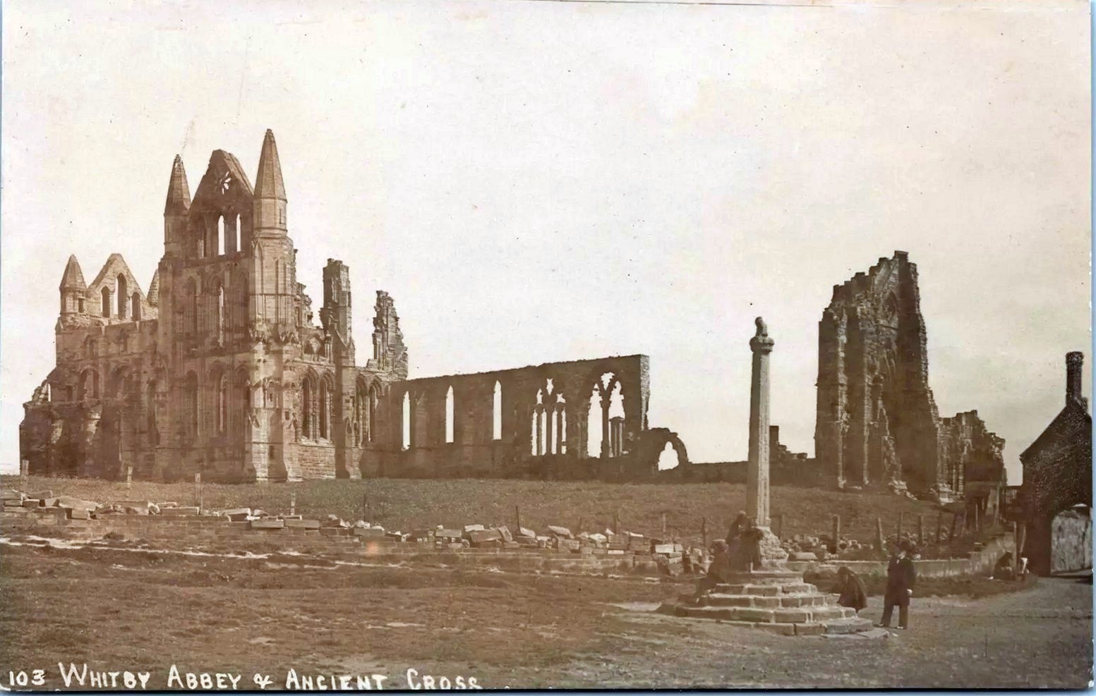
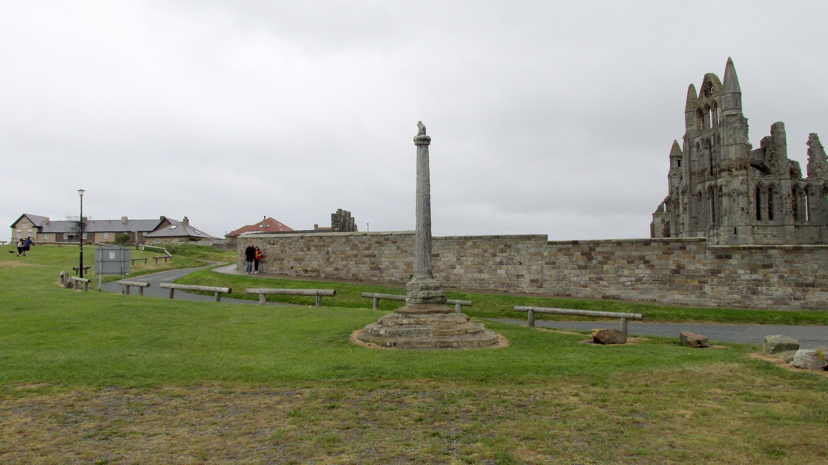
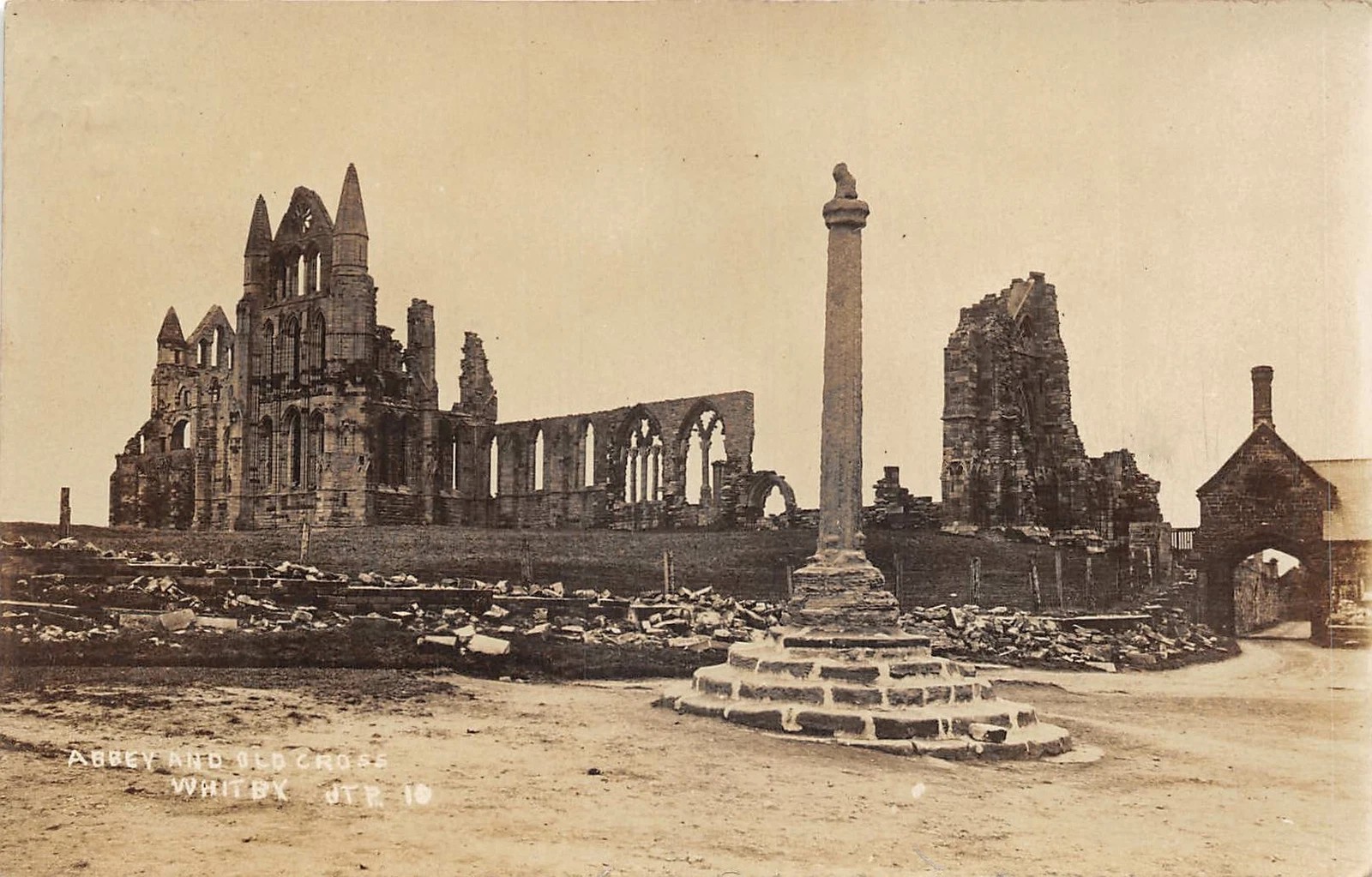
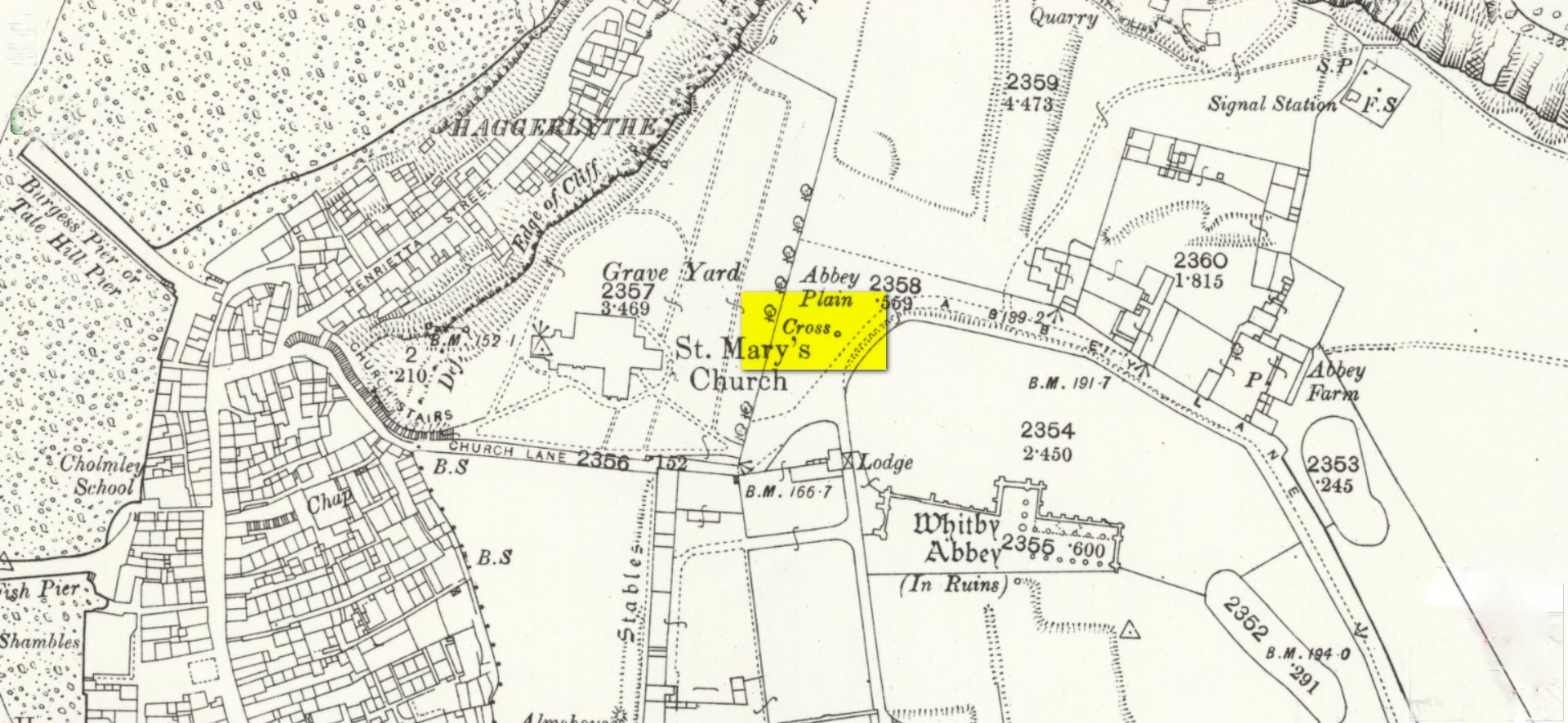
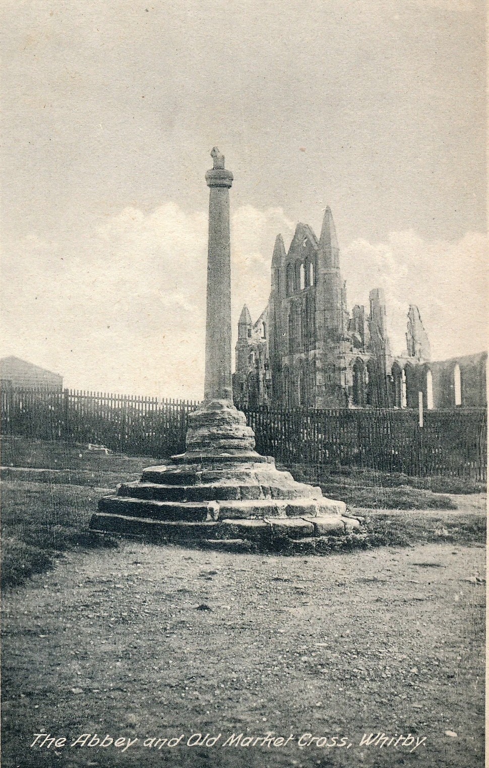
Pretty easy to find: from Whitby town centre, head uphill to the great ruins of Whitby Abbey. You go past Caedmon’s Cross and past the more recent church and graveyard to the car-park at the top, outside the abbey. At the edge of the car-park on the grass, you’ll see this tall hard upright, nice and erect!
Archaeology & History
Cross shown on 1894 map
Highlighted on the earliest OS-maps and not to be confused with the nearby and more modern Caedmon’s Cross, this tall large monolith stands upon a stepped plinth comprising of six steps (originally five), about 18 feet high. The top of the cross was knocked off a century or two ago, when it was reported to have been twenty feet! Initially it stood about fifty yards closer to the Abbey, but was removed to its present position following the Dissolution.
The brief history regarding its origin was described in George Young’s (1817) major work, in which he told that in 1474, on John Nightingale, rector of Sneaton parish, in his will “appointed his burial to be on the north side (of the Abbey), before the cross,” which was already standing at that time. Young wrote:
“By this it would appear that the ancient cross, now standing in the abbey plain was then within the cemetery of the abbey.”
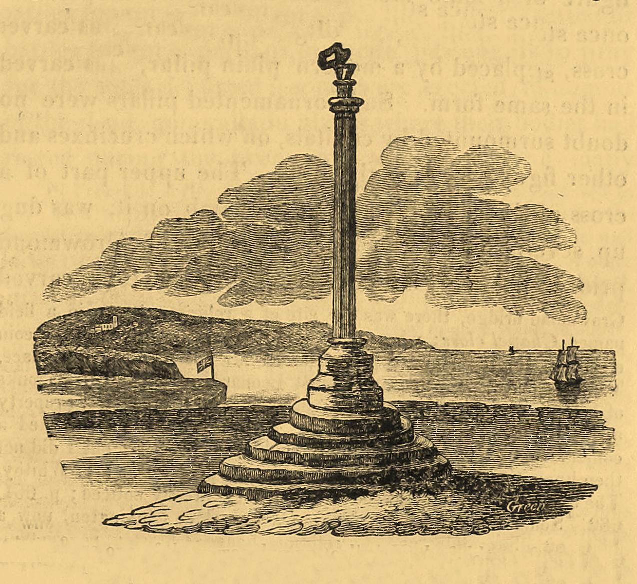
Abbey Cross, c.1900Young’s 1817 sketch
This has subsequently been taken as the standard regarding its origin. Tradition also told that it was an old market cross, but this was treated with considerable scepticism by George Young, who believed that the monks here simply wouldn’t have allowed such a thing at the edge the abbey and burial ground. He found evidence to indicate that it “was at the port or harbour of Whitby that corn was bought or sold, that here were kept the standard bushels for measuring corn, and that here the market-clerk had his station.” In spite of this, T.H. Woodwark (1934) reported that fairs had been held at the cross early in the 20th century. In a thoroughly profane way, electrical wiring was wrapped around the bottom of the cross and led to a generator, along with washing-lines running from it to a caravan! Mr Young would have been apoplectic!
References:
Atkinson, J.C., Memorials of Old Whitby, MacMillan: London 1894.
Holt, Robert B., Whitby, Past and Present, Copas: London 1890.
Woodwark. T.H., The Crosses on the North York Moors, Whitby Literary & Philosophical Society 1934.
Young, George, A History of Whitby and Streonshalh Abbey (2 volumes), Clark & Medd: Whitby 1817.
Acknowledgements:Massive thanks to Lindsay (wherefore art thou…?) Mitchell for getting us up here… Huge thanks for use of the Ordnance Survey map in this site profile, reproduced with the kind permission of the National Library of Scotland.
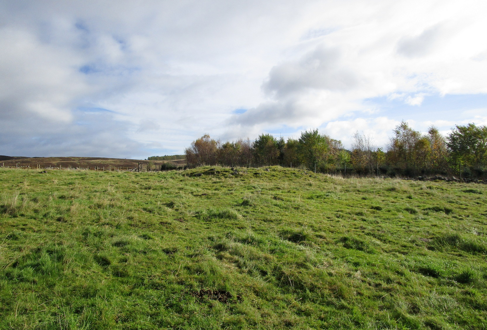
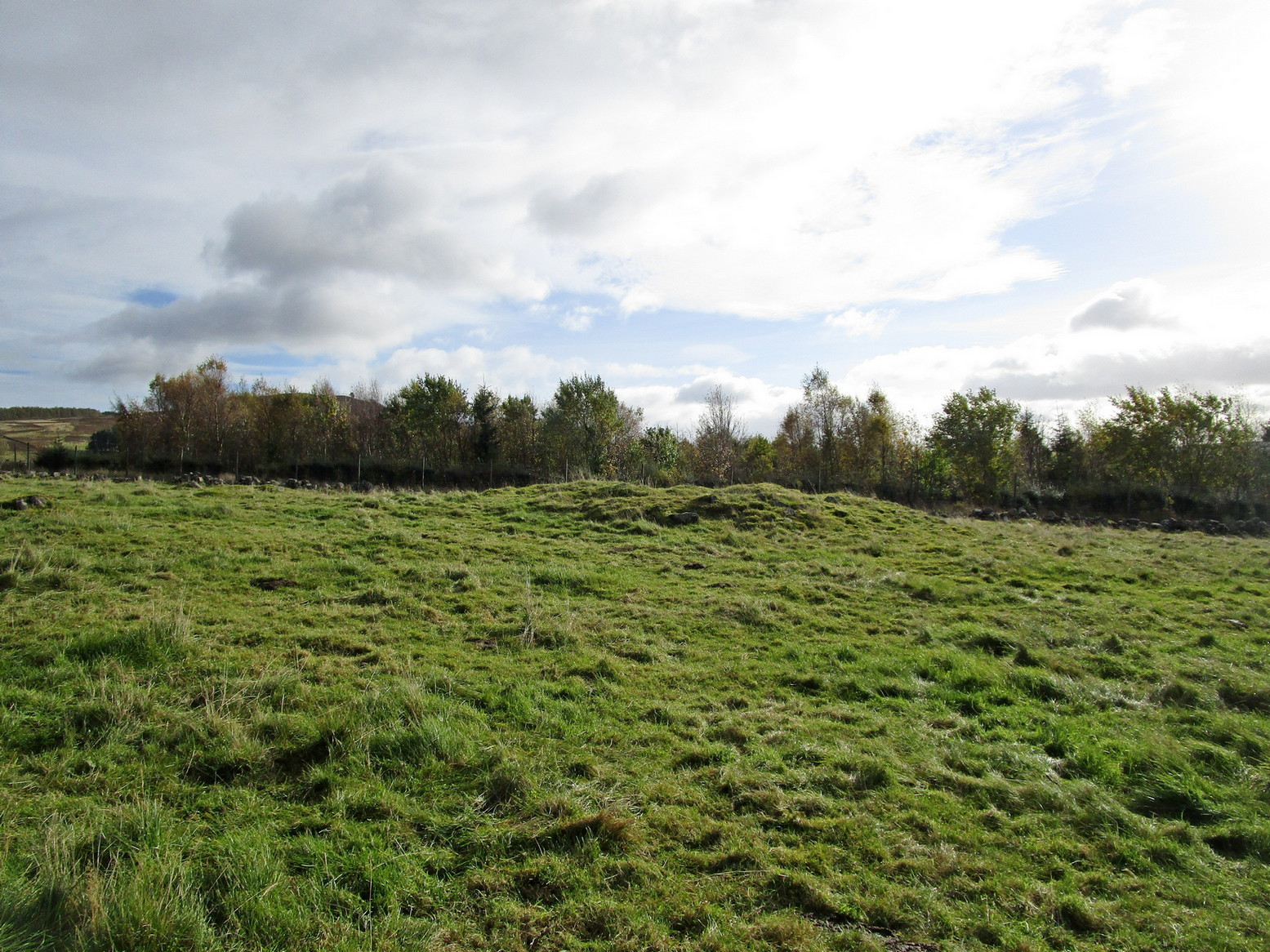
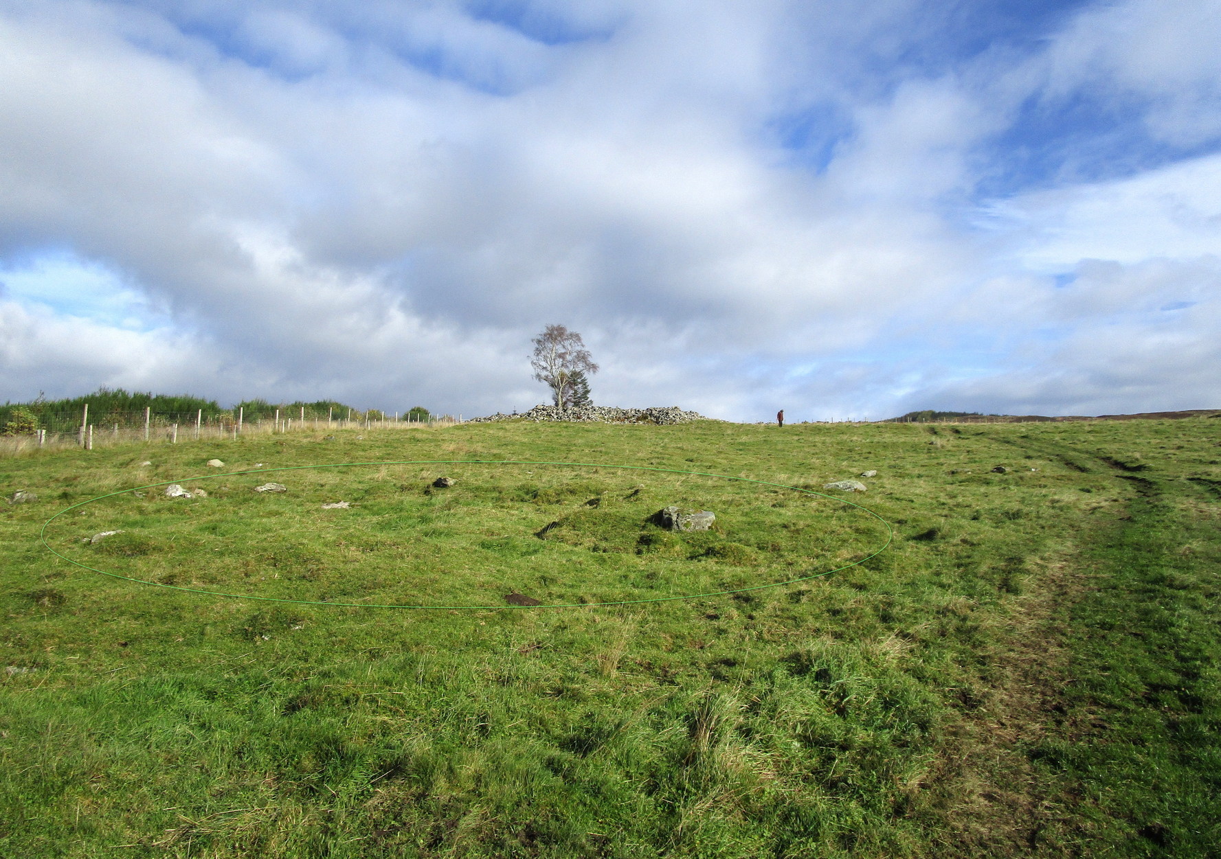
From Kirkmichael village take the A94 road 2 miles south to the Balnabroich standing stone and another 100 yards past it, on the left (east) take the dirt-track uphill, following the directions to reach the Balnabroich hut circles. You’ll see the large prehistoric rock pile of the Grey Cairn on the near skyline just above the huts and roughly on the same level, 50 yards away to the south, you’ll see this scruffy lumpy dump of a cairn, all overgrown.
Archaeology & History
The cairn, looking S
Amidst the veritable scatter of a thousand clearance cairns (yes, that’s the estimate), there are a few up here that had more funerary functions than the rest. This being one of them. When Allan Stewart (1795) wrote about them all in the Statistical Account, he couldn’t have missed this one—and yet he made no mention of it. We had to wait another seventy years before the outside world became aware of its existence. Then, along with “a band of between twenty and thirty workmen,” John Stuart (1865) set out to see what lay beneath the rocky pile. In truth, much more attention was given to the huge Gray Cairn close by (understandably so), but at least some attention was given here. Stuart described this cairn as,
“about 9 yards across, defined by large boulders, with a raised ridge around, and a cup in the centre. The raised ridges and centre were all formed of small stones and earth. A trench was cut through it from the southeast, which showed that in the centre, at a depth of 2 feet, a deposit had been made, of which the remains were charred wood and fragments of charred bone, with traces of blackish matter, which had filtered into the yellow subsoil, as in the case of the graves at Hartlaw.’ Many fragments of white quartz pebbles appeared near the centre, as in other cairns to the east.”
Indeed, at least one of the “cairns to the east” is made entirely of quartz stones! Since Mr Stuart’s dig into the tomb, it has widened out slightly as rummaging cattle and other damage has been inflicted, and the grasses have coloured the tomb with their life. Check it out when you’re up here!
References:
MacLagan, Christian, The Hill Forts, Stone Circles and other Structural Remains of Ancient Scotland, Edmonston & Douglas: Edinburgh 1875.
Ramsay, John S., Highways and Byways of Strathmore and the Northern Glens, Blairgowrie Advertiser 1927.
Royal Commission on the Ancient & Historical Monuments of Scotland, North-East Perth: An Archaeological Landscape, HMSO: Edinburgh 1990.
Stewart, Allan, “Parish of Kirkmichael,” in Statistical Account of Scotland – volume 15, 1795.
Stuart, John, “Account of Excavations in Groups of Cairns, Stone Circles and Hut Circles on Balnabroch, Parish of Kirkmichael, Perthshire,” in Proceedings Society Antiquaries, Scotland, volume 6, 1865.
Acknowledgements:Huge thanks for use of the Ordnance Survey map in this site profile, reproduced with the kind permission of the National Library of Scotland.
Sitting quietly “on the village green, where the fair is still held,” wrote Wigram (1885), “stands the base of the old market-cross, reduced to a shapeless stump, but still bearing traces of leaden setting.” Thought to be mediaeval in age, it was described as a sundial on some of the early Ordnance Survey maps which, perhaps, it may have been used as for a short period (although records are silent on the matter). Standing just three-feet tall, this old stone pillar still lives on its ancient spot, as quiet as always, keeping itself to itself…
References:
Wigram, S.R., Chronicles of the Abbey of Elstow, Parker & Co.: Oxford 1885.
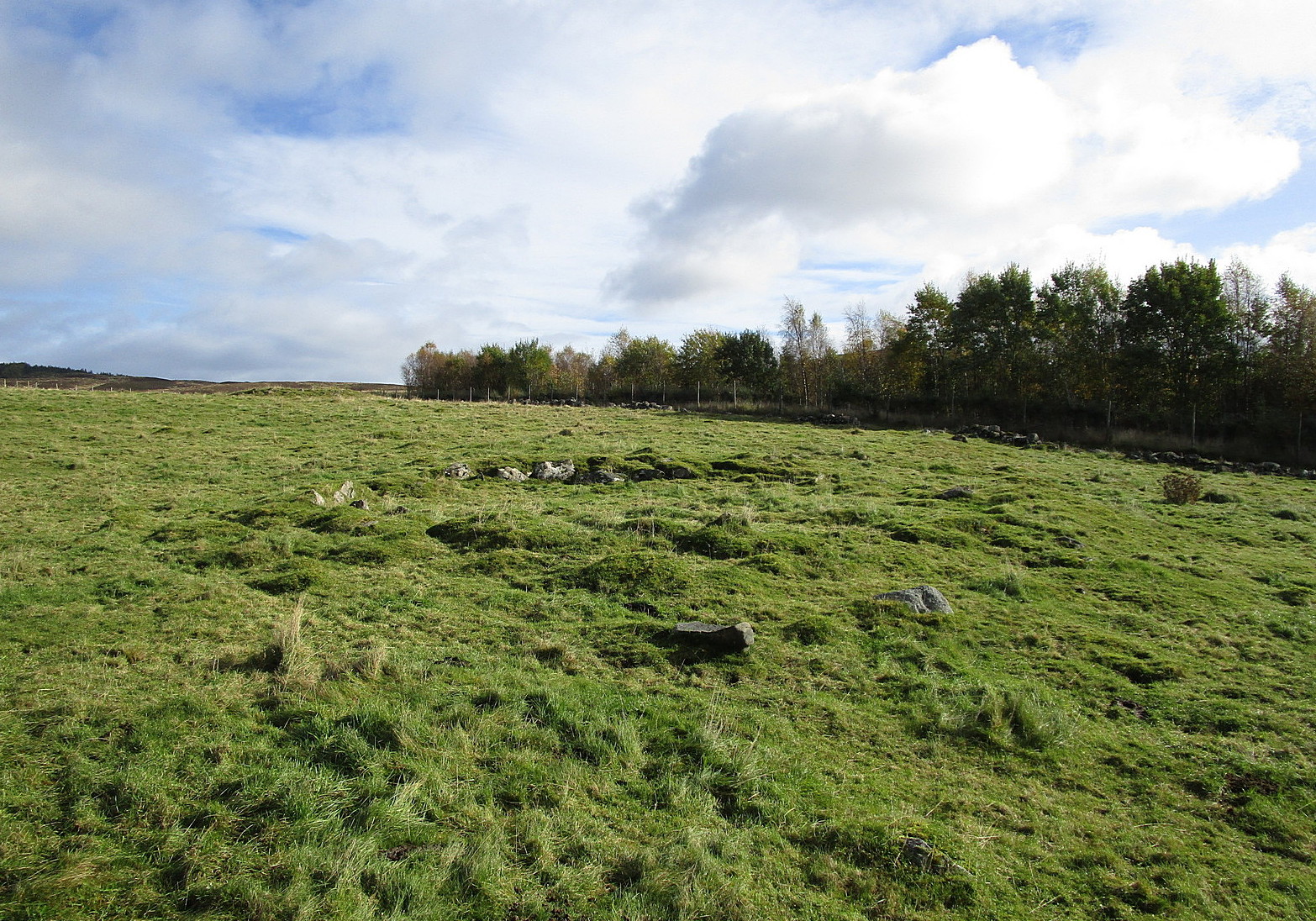
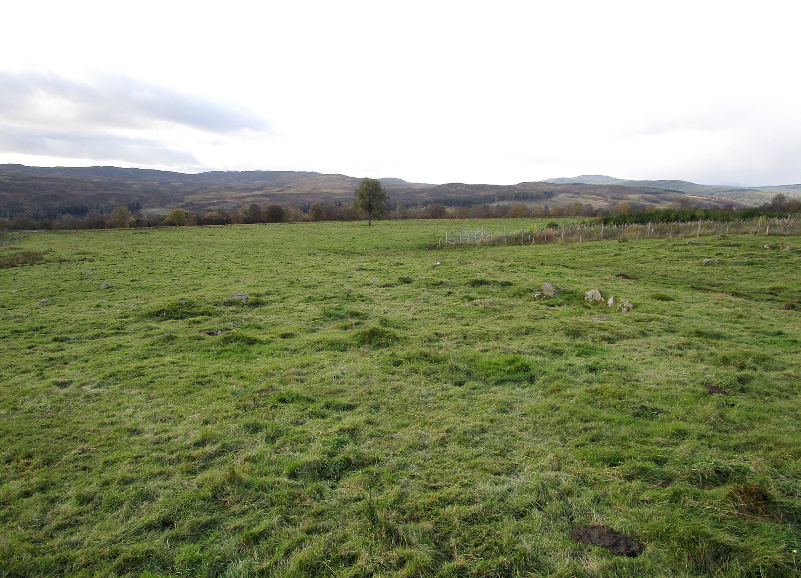
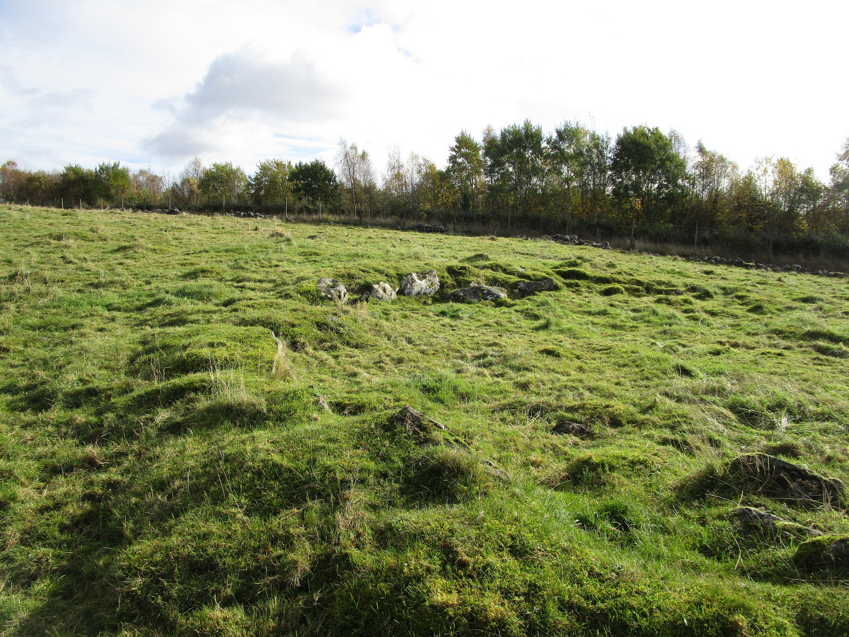
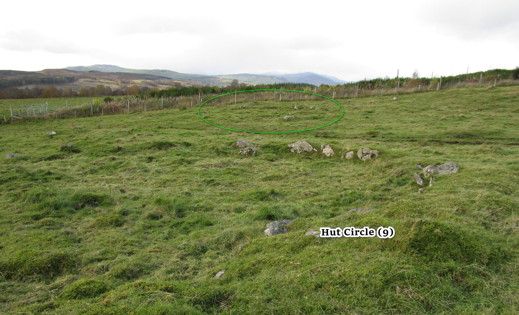
Along the A924 Strathardle road, a couple of miles south of Kirkmichael, about 100 yards south of the Balnabroich standing stone, look out for the dirt-track that runs up the slope on the east side of the road. Go up here, past Stylemouth house and further up the track where it opens out into the fields. Keep heading up the same track and you’ll notice on the near skyline a few hundred yards ahead of you, a mass of stones with a tree growing out of it. That’s the Grey Cairn; and about 75 yards below it, just to the right-side of the path low down in the grasses, you’ll see this hut circle.
Archaeology & History
In an upland area that is literally teeming with ancient remains, this is a good place to start if you’re wanting a day out exploring. It’s the best and easiest of the hut circles to find and is a good indicator of what to look for when you’re seeking out the others close by. This particular prehistoric house has been noted in various books and essays: firstly by the great Scottish antiquarian John Stuart (1868) in his overview of the great mass of sites hereby, saying simply:
“A hut circle on the south-west of the Grey Cairn was dug into around the entrance, in the belief that in this situation articles would probably have been thrown out, but with no result. In the centre, charred wood and minute fragments of bones were found.”
Looking from above
Arc of walling north to east
The great Christian MacLagan (1875) came to survey the area shortly after Stuart’s visit, making a series of sketches of some of the circles. She noted fourteen huts hereby, but it’s not totally clear which of them is this particular “hut 9”. It seems to have been her hut circle no.13, which she told “has a central chamber 40 feet in diameter, and its wall is 10 feet broad.” This is pretty close to our modern measurements. From outer wall to outer wall, its east-west axis measures 47 feet, and its north-south axis measures 49 feet. The most notable section of the walling is on is northern and eastern sides where it is deeply embedded into the ground.
When you’re sitting in this hut circle, eating your sandwich or drinking your juice, remember that thousands of years ago someone was doing exactly the same thing in the place where you’re now sat!
Just 70 feet away is hut circle no.10 in this cluster; whilst above this is the massive prehistoric rock pile of the Grey Cairn; and the smaller earth-covered mound above you to the right is another prehistoric burial. A small stone circle is on the moorland level beyond that… There’s plenty to see here.
References:
Coutts, Herbert, Ancient Monuments of Tayside, Dundee Museum 1970.
Harris, Judith, “A Preliminary Survey of Hut-circles and Field Systems in SE Perthshire”, in Proceedings Society Antiquaries, Scotland, volume 114, 1984.
MacLagan, Christian, The Hill Forts, Stone Circles and other Structural Remains of Ancient Scotland, Edmonston & Douglas: Edinburgh 1875.
Royal Commission on the Ancient & Historical Monuments of Scotland, North-East Perth: An Archaeological Landscape, HMSO: Edinburgh 1990.
Stuart, John, “Account of Excavations in Groups of Cairns, Stone Circles and Hut Circles on Balnabroch, Parish of Kirkmichael, Perthshire,” in Proceedings Society Antiquaries, Scotland, volume 6, 1865.
Thorneycroft, Wallace, “Observations on Hut Circles near the Eastern Border of Perthshire, north of Blairgowrie,” in Proceedings Society Antiquaries, Scotland, volume 67, 1933.
Acknowledgements:Huge thanks for use of the Ordnance Survey map in this site profile, reproduced with the kind permission of the National Library of Scotland.
From Kirkmichael to the Balnabroich standing stone, take the same directions as if you’re heading up to the Balnabroich hut circle (9). Just over 20 yards NNW of it, on the other side of the faint footpath that takes you to the Grey Cairn, look closely at the ground and you’ll see a broken oval of stones in the grasses.
Archaeology & History
This can be difficult to see in poor light, and I found it easier to look at from above, closer to the Grey Cairn.
Hut remains, circled
It’s one of the twenty (known) hut circles in this archaeologically rich neck o’ the woods. Nothing special to look at, but it is perhaps 4000 years old! This one seems to have been listed by Christian MacLagan (1875) as her hut circle no.12 and which she described briefly, telling that “the central chamber of this circle is 36 feet in diameter, and the surrounding wall is 15 feet broad.” Much of the walling would seem to have been stripped away considerably since MacLagan’s time. The faded remains of its entrance can be seen on its southwestern side.
References:
Coutts, Herbert, Ancient Monuments of Tayside, Dundee Museum 1970.
Harris, Judith, “A Preliminary Survey of Hut-circles and Field Systems in SE Perthshire”, in Proceedings Society Antiquaries, Scotland, volume 114, 1984.
MacLagan, Christian, The Hill Forts, Stone Circles and other Structural Remains of Ancient Scotland, Edmonston & Douglas: Edinburgh 1875.
Royal Commission on the Ancient & Historical Monuments of Scotland, North-East Perth: An Archaeological Landscape, HMSO: Edinburgh 1990.
Stuart, John, “Account of Excavations in Groups of Cairns, Stone Circles and Hut Circles on Balnabroch, Parish of Kirkmichael, Perthshire,” in Proceedings Society Antiquaries, Scotland, volume 6, 1865.
Thorneycroft, Wallace, “Observations on Hut Circles near the Eastern Border of Perthshire, north of Blairgowrie,” in Proceedings Society Antiquaries, Scotland, volume 67, 1933.
Acknowledgements:Huge thanks for use of the Ordnance Survey map in this site profile, reproduced with the kind permission of the National Library of Scotland.
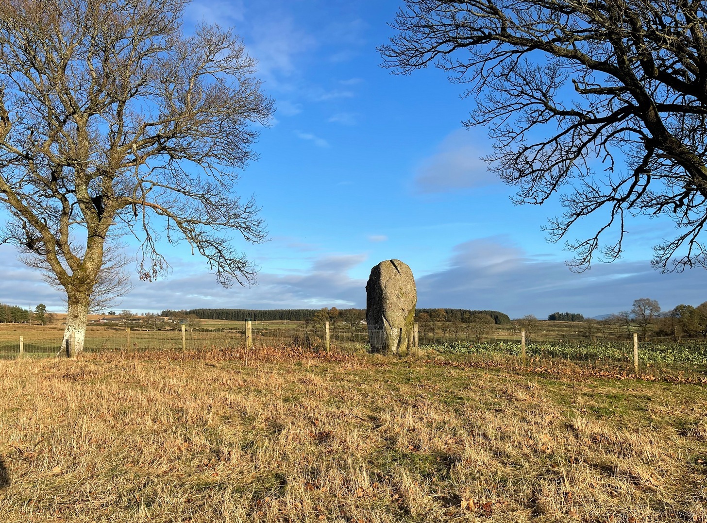
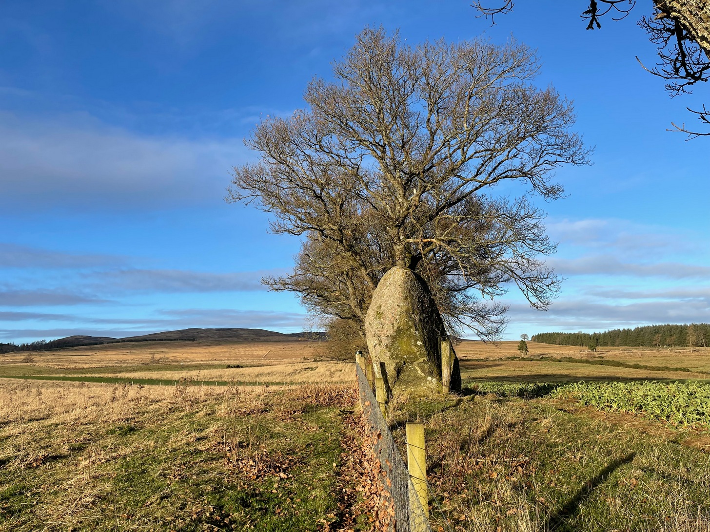
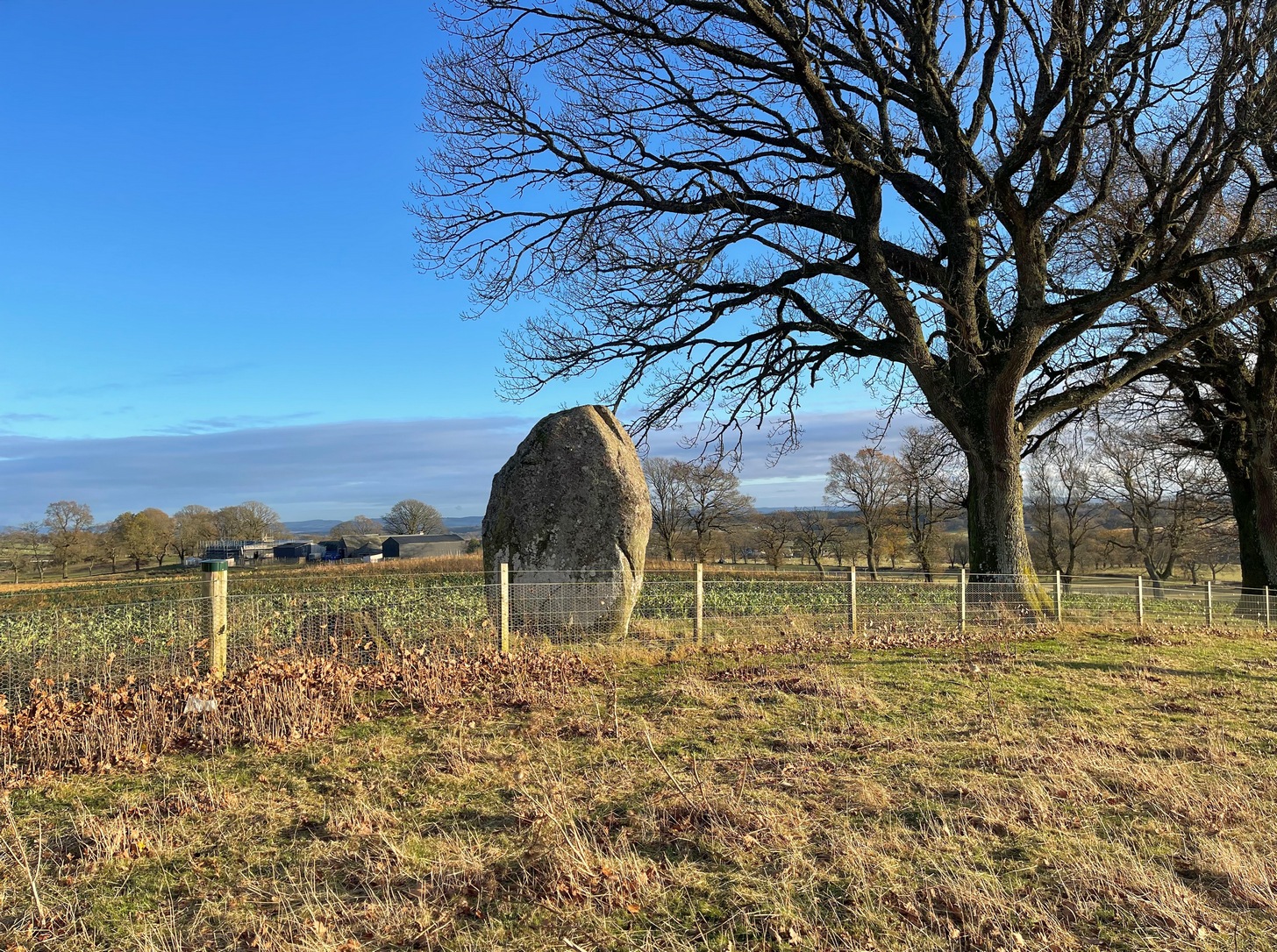
Travel along the B867 road from Bankfoot to Dunkeld (running roughly parallel with the A9) and you’ll reach the hamlet of Waterloo about one mile north of Bankfoot. As you approach the far end of the village, keep your eyes peeled for the small turning on your left and head up there for just over a mile. The road runs to a dead end at Meikle Obney farm, but shortly before reaching there you’ll pass this large standing stone on the right-side of the road, just along the fence-line. It’s almost impossible to miss!
Archaeology & History
This is one of “the large rude upright stones found in the parish” that William Marshall (1880) mentioned briefly, amidst his quick sojourn into the Druidic history of Perthshire. It’s an impressive standing stone on the southern edges of the Obney Hills that doesn’t seem to be in its original position. And it’s another one that was lucky to survive, as solid metal staples were hammered into it more than a hundred years ago when it was incorporated into the fencing, much like the massive Kor Stone 6½ miles south-west of here.
Site shown on 1867 mapWitch’s Stone at roadside
Shown on the first Ordnance Survey map of the area in 1867, its bulky 6½-foot-tall body stands all alone on this relatively flat plain, with open views to the east, south and west. It gave me the distinct impression that it was once part of a larger megalithic complex, but I can find no additional evidence to substantiate this. Call it a gut-feeling if you will. Intriguingly, the closest site to this are two standing stones just out of view literally ⅔-mile (1.07km) to the northeast, aligned perfectly to the Witch’s Stone! Most odd…
Folklore
The story behind this old stone is a creation myth that we find all over the country, but usually relating to prehistoric tombs more than monoliths. The great Fred Coles (1908) wrote:
“the common legend is told of a witch who, when flying through the air on some Satanic behest, let the Stone fall out of her apron.”
Marshall, William, Historic Scenes in Perthshire, William Oliphant: Edinburgh 1880.
Stewart, Elizabeth, Dunkeld – An Ancient City, Munro Press: Perth 1926.
Acknowledgements:Huge thanks for use of the Ordnance Survey map in this site profile, reproduced with the kind permission of the National Library of Scotland.
Take the tiny long winding B8063 road that runs west off the A9 at Luncarty, meandering eventually to the entry of the Sma’ Glen. If you’re coming via Luncarty, after going west for 8 miles (12.9km) you pass the hamlet of Harrietfield and just a few hundred yards further a dirt-track on your right goes uphill to Milton. If you’re coming via Crieff/Sma’ Glen direction, along the B8063 road, cross the Bridge of Buchanty and after nearly 3 miles (4.7km) just past a bit of a hairpin, you’ll see the track up to Milton on your left. Walk up, past all the newly modernised houses and go through the gate, bearing right where, in the field on your right (thru another gate) you’ll see this big fella standing alone 200 yards to the east along the fence-line.
Archaeology & History
Looking N to Crochan Hill
This is a bit of a hidden beauty! Standing nearly ten feet tall on the crest of an elongated ridge with the land ever so gently declining either side of its proud stand, it beckons the impression of partners long since gone (or something truly olde)… and so it proved to be. Very little has been written about the place, despite its impressive stature. It seems to have been described firstly in J.W. Thomson’s essay on the local parish in April 1837 (subsequently published in the NSA in 1845) where, ascribing it as usual to the druids of olde, he told that,
“at the western extremity of Logiealmond, there is one remarkable block about 12 feet high and 18 feet in circumference, standing upon its narrow end, with three other stones in its immediate vicinity. It is commonly called the Kor Stone.”
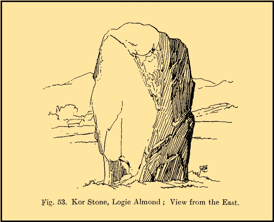
Kor Stone, looking SE
Fred Coles’ 1911 sketch
William Marshall (1880) also mentioned these three additional standing stones, saying that they were “apparently part of a row.” But they are long gone and we know not what became of them. They were probably uprooted and included in some of the nearby walling or buildings (quite a lot of suspicious-looking stones scatter the edges of many fields around Logiealmond). If we look closely at the surface of our Kor Stone, in earlier times someone has fixed metal loops into the monolith to make it part of an early fence or gate.
The stone was highlighted on the 1867 OS-map of the area and described in the accompanying Name Book,
“Carse” Stone on 1867 map
“A stone about ten feet high, supposed by some people to be the remains of a Druidical Circle, by others to be a mark on a division of lands: in support of the latter supposition they bring forward the fact of a large stone at Dunkeld and one near Fowlis – both similar to this one – and The Carse Stane being in the same straight line.”
The great Fred Coles (1911) also gave the place his attention, but apart from a brief description of its size and position, he found no additional lore about the other three stones, telling us simply:
“It is an imposingly large and erect block of rugged whinstone, 9 feet 9 inches in height, with a basal girth of 15 feet 10 inches, but at about midway of its height the girth increases to fully 17 feet. The view…shows the Stone as seen from the east.”
In truth, the location of this giant stone on the ridge strongly suggests it was once part of a much greater megalithic neolithic monument. But whatever that might have looked like, we may never know. It’s an awesome site though. Well worth checking out if you’re in the area.
Finlayson, Andrew, The Stones of Strathearn, One Tree Island: Comrie 2010.
Marshall, William, Historic Scenes in Perthshire, William Oliphant: Edinburgh 1880.
Thomson, J.W., “Parish of Moneydie,” in New Statistical Account of Scotland – volume X: Perth, William Blackwood: Edinburgh 1845.
Acknowledgements:Huge thanks for use of the Ordnance Survey map in this site profile, reproduced with the kind permission of the National Library of Scotland.