Stone Circle (destroyed): OS Grid Reference – SM 8615 1428
Archaeology & History
Described in context with an extant standing stone 100 yards to the north, this stone circle seems to have been destroyed in the latter half of the 19th century. It was described in the Royal Commission’s huge Pembrokeshire (1925) survey, after they had visited the site and viewed the remains. They told us:
“On the side of the road immediately opposite to Cliff Cottage, and constituting part of the garden walls of Upper Lodge, are numerous boulders which formed a well-defined stone circle. A few years ago they were moved, dressed, and used for walling. The entrance to the circle is said to have faced north-east. The southern portion was still visible about the year 1896.”
As far as I’m aware, local people report that a couple of the stones are still visible in the overgrown walling. Students working for the Welsh Coflein database allege that the remaining stones “are of doubtful antiquity.” Unless they have some substantial evidence to validate this statement (none is given) their remarks should be taken with a pinch of salt.
References:
Royal Commission Ancient & Historical Monuments, Wales, An Inventory of the Ancient Monuments in Wales & Monmouthshire: VII – County of Pembroke, HMSO: London 1925.
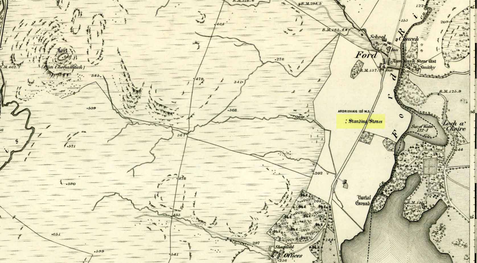
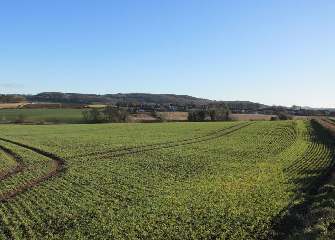
Unless you’re venturing down the tiny Loch Awe roads, the easiest way here is to turn right off the A816 Lochgilphead-Oban road, 1½ miles north of Kilmartin. Go along this winding minor road for literally 2½ miles where, after coming out the tree-lined road, just past the small Loch Ederline, the fields re-appear on both sides of the road. Just here, where the trees end, just a few hundred yards before the hamlet of Ford, in one of the field on the left, you’ll see a tall upright stone. That’s it!
Archaeology & History
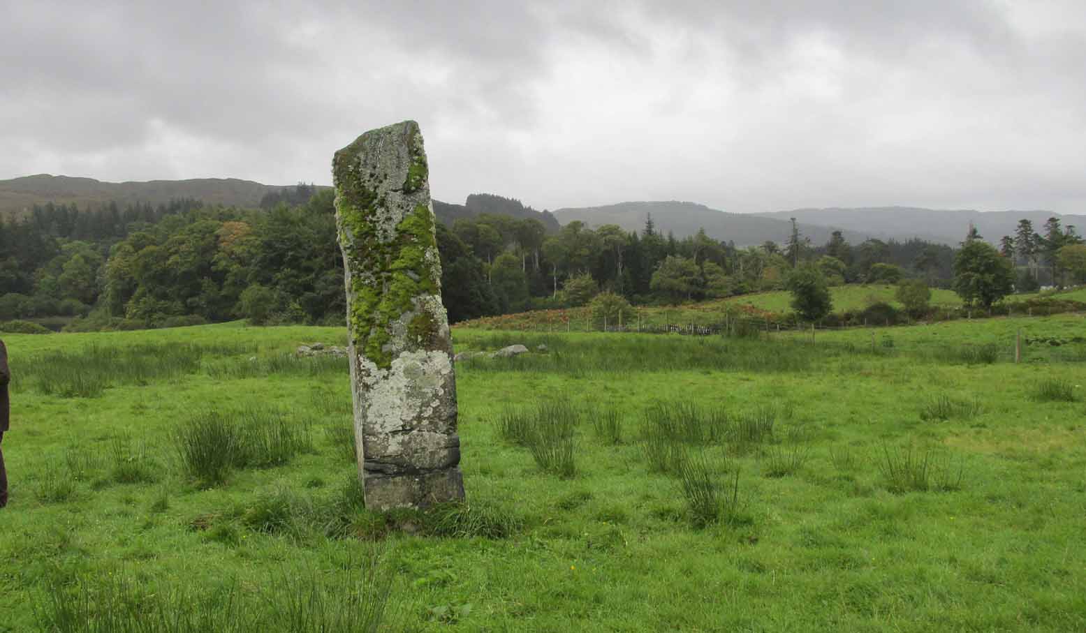
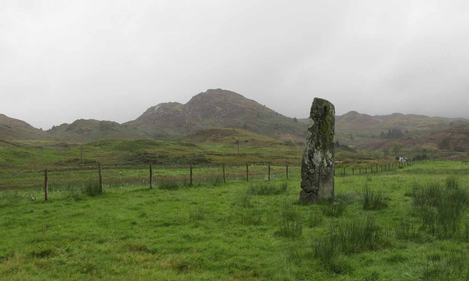
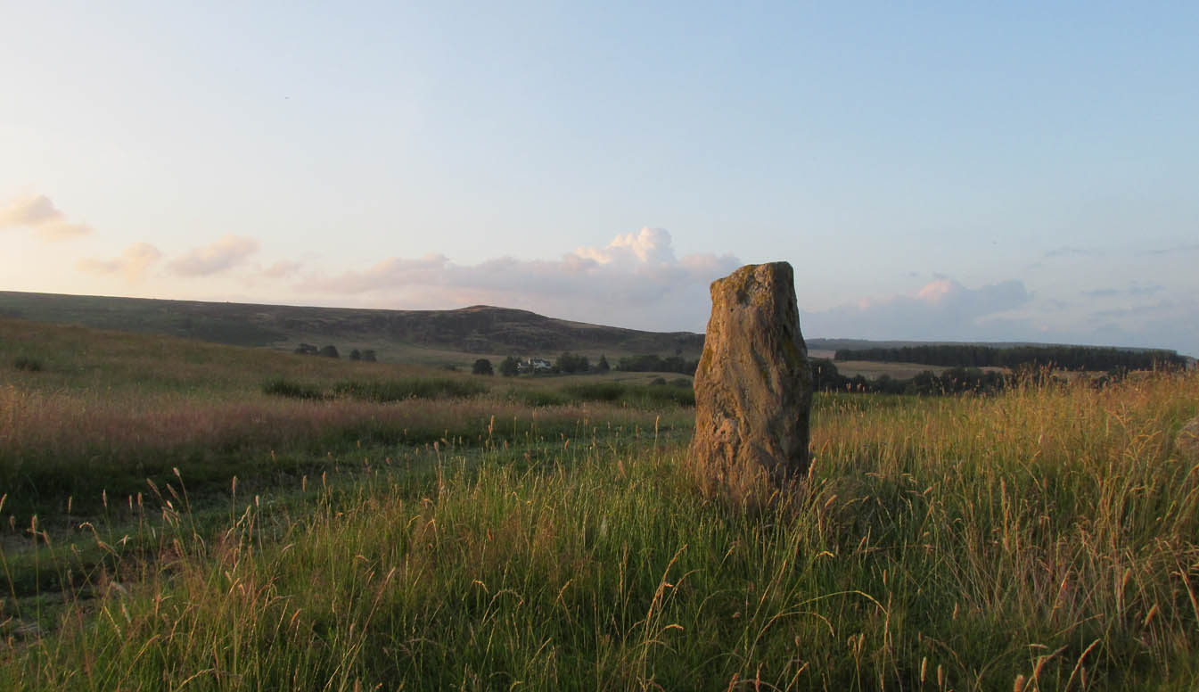
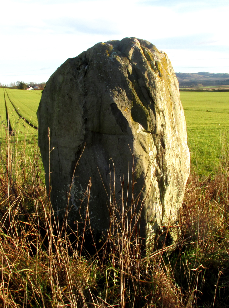
I was very fortunate, many years ago, to live in the old farmhouse of Auchinellan in the trees by this ancient stone. It became a companion of mine many-a-time, as I sat with it in rain and mist and darkness sometimes, beneath the bright Moon. It always had a good feeling about it. And so when a small bunch of us visited here again recently, it was almost as if I’d never been away. Tis a magickal part of our landscape.
The old stone looking NThe old stone looking NW
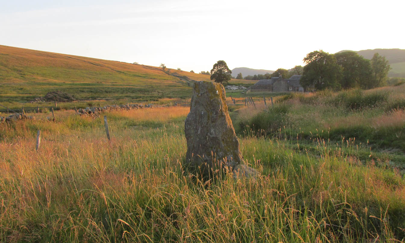
Standing ten-foot-tall on a grassy plain with craggy hills all round, this old fella once had a companion close by its side—a stone one! Accounts of it are curious to say the least, with one telling us that it was only “a few inches high” – which is just daft. The now-lost stone was in fact about six-feet tall and the story of its disappearance was that it was moved into the grounds of Auchinellan House where I used to live, somewhere in the garden. I could never find it, and local folk told me that the old fella who lived in the mansion would have known about it, but died shortly before I moved in. Clive Ruggles (1984) told that it could be found at grid-reference NM 8653 0268, but that would be smack bang on the manor house.
As far as I can tell, the first written testimony of this stone was by the Ordnance Survey lads after they’d visited here in 1871 and, several years later, highlighted it on their maps. (above) On this is clearly shown, just yards apart, the two standing stones. Much later, when the Royal Commission (1988) doods did their survey, they described the stone in their usual brief way:
“Situated on the top of a slight rise in a pasture field 270m SW of the Ford Hotel, there is a standing stone which measures 0.7m by 0.55m at the base and rises with straight sides to a flat top at a height of 3m…”
The site was included in Thom’s (1990) major survey on prehistoric stone rows where, again, only a brief description is given, saying:
“On a terrace near Loch Ederline is a standing stone which leans to the E. It is 9ft 6 (2.9m) high.”
It’s a beautiful place in a beautiful setting and is one of countless prehistoric monuments in this part of Scotland. Well worth having a look at.
Folklore
The Gaelic names for this site—Achnacarra and Achadh nan Carradh—means “the field of the burial stone”, which relates to the folklore of the stones reputedly marking the place of an ancient grave.
Campbell, Marion & Sandeman, M., “Mid Argyll: An Archaeological Survey,” in Proceedings Society of Antiquaries Scotland, volume 95, 1964.
Royal Commission on the Ancient & Historical Monuments of Scotland, Argyll – Volume 6: Mid-Argyll and Cowal, HMSO: Edinburgh 1988.
Ruggles, Clive L.N., Megalithic Astronomy, BAR: Oxford 1984.
Thom, Alexander, Thom, A.S. & Burl, Aubrey, Stone Rows and Standing Stones – volume 1, BAR: Oxford 1990.
Acknowledgements: Big thanks to Neens Harris, Paul Hornby & Frank Mercer. And the stunning resource of Scotland’s 1st edition OS-maps is Reproduced with the kind permission of the National Library of Scotland.
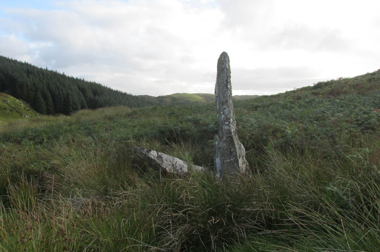
Roughly halfway between the staggering standing stone at Kintraw and the farmhouse of Salachary a coupla miles east along the A816 road to Kilmartin, a small overgrown car park nearly hides on the south-side of the road, just below the forestry. 50 yards west of this, a small track winds uphill. 650 yards (0.6km) up here, once it levels out, a hairpin in the track veers NW; ignore it, instead walking into the marshy grass in front of you (south) for 50-60 yards up and round the small rocky crag. Once you get round the edge of this, immediately east, you’ll see one of the tall monoliths 50 yards ahead of you.
Archaeology & History
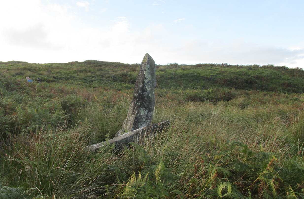
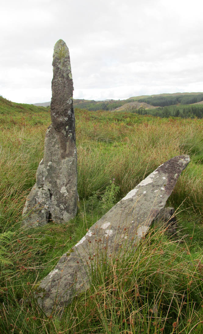
Rediscovered in recent times by Marion Campbell (1962), this damaged row of three tall standing stones is cited in Swarbrick’s (2012) poorly-arranged survey as being “difficult to find in broken ground”; although patience brings the stones clearly into sight for any explorer. They’re big too! Sadly only one of them still remains fully upright—but that one’s nearly 9 feet tall!
In Miss Campbell’s initial description of the site, following their rediscovery, she told how,
“A chance sighting led to the discovery of a group of three monoliths, one erect, one sloping and one prostrate, on the West side of a wide glen leading S from the upper part of the Bealach Mor; the site commands a fine view into the northern hills. The spot is about 550ft above sea level and this is therefore the highest group of standing stones so far recorded in the area.
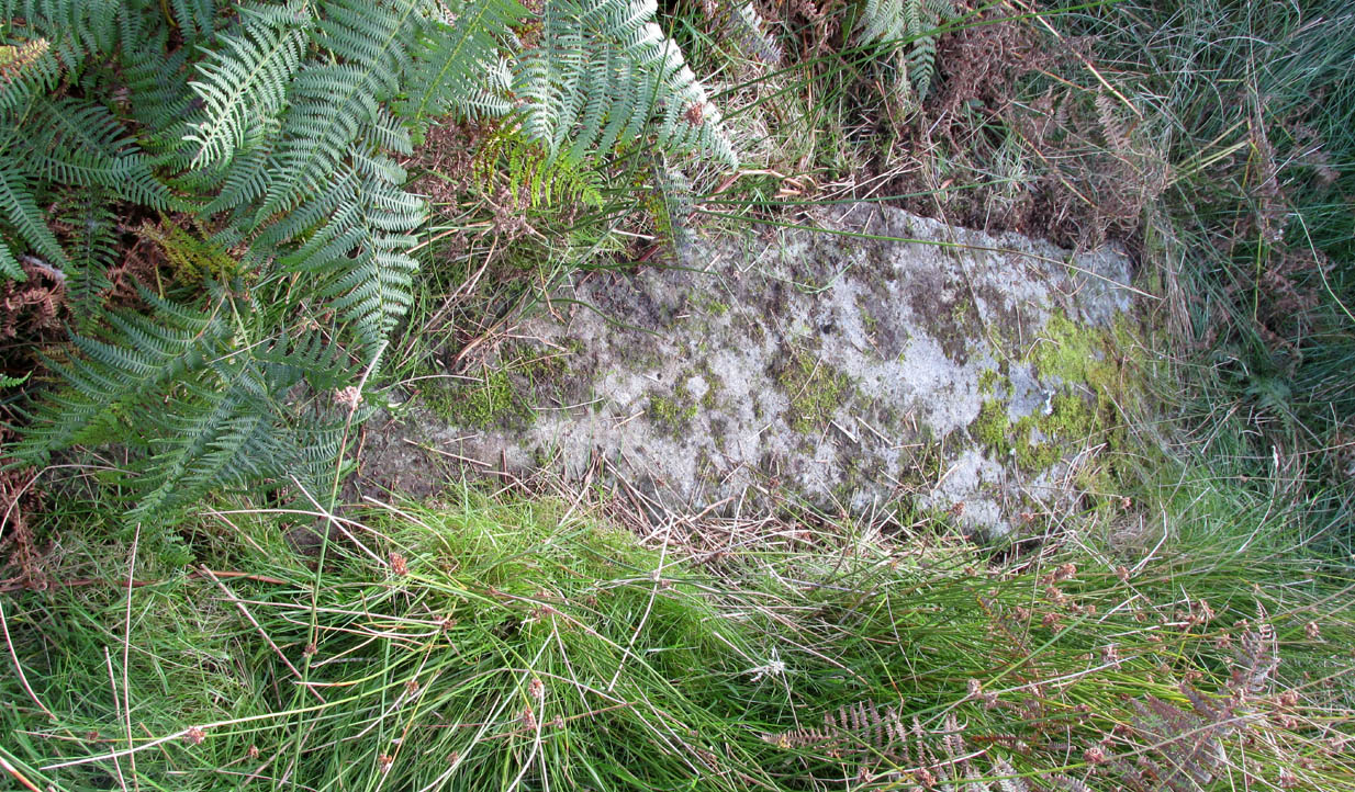
“The erect stone is 8ft 4in x 2ft x 1 ft, lozenge-shaped in section, with a pointed top. The leaning stone, also lozenge-shaped, is 10ft x 1ft 8in x 1ft, and pointed. The fallen stone is over 11ft x 2ft wide, too deeply buried in turf for the thickness to he measured. The stones appear to have stood in line, the nearest points of the first and third stones 9ft apart and the line joining them running north and south. Along a ridge running S behind the stones are a number of small ruins, oval and rectangular, in old cultivations. No surviving placename has been recovered for the site so far.”
Section of the fallen stoneLooking west
Indeed, no subsequent investigation has led to either an early name nor any traditions about the site, and the stones cannot be found on any early maps of the area. A pity, as they’re quite impressive stones and would have had some old stories known of them in ages gone by.
Twenty years after Miss Campbell’s discovery, in May 1982, the stones were visited and surveyed by the Royal Commission lads. Their description very much tallied with Miss Campbell’s, but it’s worth citing anyway. They told us that:
“On a terrace on the W side of an unnamed valley to the S of Bealach Mor and about 850m SW of Salachary, there is a setting of three large standing stones which is aligned from N to S. Only the N stone is still upright; it measures 0.7m by 0.72m at the base and rises with straight sides to a pointed top at a height of 2.75m. The central stone is of similar proportions, but it now leans to the NE at an angle of about 15° to the horizontal. The S stone, which measures 3.4m by 0.65m has fallen with its top to the SE.”
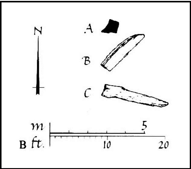
Royal Commission planAlexander Thom’s plan
Around the same time, Clive Ruggles (1984) assessed the Salachary stones for any potential astronomical alignments and found—as Alexander Thom & Aubrey Burl did in their own survey (1990)—that as they pointed virtually north-south they stood beyond any solar or lunar functions. Thom found the stones align almost perfectly north-south, with a notch in the southern horizon at 178°, and on the northern horizon the hilltop of Meall Reamhar at 2° west of north. This northern line may relate to the airt of death, although no other immediate archaeological remains have been found to fortify this idea (however, other unrecorded standing stones are close by and their relationship with Salachary has yet to be adequately assessed).
Aubrey Burl’s first description of this stone row told us:
“There are three stones in a N-S row situated on a terrace on the W side of a glen. The N stone, with a pointed top, stands 8ft 4 (2.5m) high. The central stone leans dramatically at 20°. It is 10ft (3m) in length. The S stone is prostrate and half-buried. It is 11ft (3.4m) long. The row is about 13ft (4m) long. From the site there is a fine view of the northern hills.”
Looking north
In truth, the main north-south axis relates to the more open geological avenue of the landscape. Both the east and west are all but blocked by crags and hills, and the stones seem to have been positioned to echo the hollowed section of the landscape. The land runs in curious geological folds and has a distinct genius loci which I enjoyed in differing (usually wet) conditions when I used to live nearby. The site is well worth a walkabout if you’re in the area – and there are more unrecorded stones still hiding in Nature’s rocky folds nearby.
References:
Burl, Aubrey, From Carnac to Callanish, Yale University Press 1993.
Campbell, M. & Sandeman, M., “Mid Argyll: An Archaeological Survey,” in Proceedings Society Antiquaries Scotland, volume 95, 1964.
Campbell, Marian, ‘Salachary, Kintraw’, in Discovery & Excavation Scotland, 1962.
Ferguson, Lesley, “A Catalogue of the Alexander Thom Archive Held in the National Monuments Record of Scotland,” in Records in Stone (ed. C. Ruggles), Cambridge University Press 1988.
Royal Commission on the Ancient & Historical Monuments of Scotland, Argyll – volume 6: Mid-Argyll and Cowal, HMSO: Edinburgh 1988.
Ruggles, Clive L.N., Megalithic Astronomy, BAR: Oxford 1984.
Ruggles, Clive L.N., “The Stone Alignments of Argyll,” in Records in Stone (ed. C. Ruggles), Cambridge University Press 1988.
Swarbrick, Olaf, A Gazetteer of Prehistoric Standing Stones in Great Britain, BAR: Oxford 2012.
Thom, A., Thom, A.S. & Burl, Aubrey, Stone Rows and Standing Stones – volume 1, BAR: Oxford 1990.
Weston, Garth, Monuments and Mountains, Ashridge: Bakewell 2007.
Acknowledgements: This site profile could not have been written without the help and of Nina Harris, Paul Hornby, Frank Mercer and Belinda Sales.
From Pickering, take the A169 towards Whitby. When you get to the Car Park at the ‘Hole-of-Horcum’ – (you can’t miss it), park the car and walk North along the side of the road towards Whitby. After 60 yds, take the track East. Follow this for approximately a mile until the track splits. Take the concrete track left towards the farm-house of ‘Newgate Foot’. Go through the yard past the house on the right, and you will come to a stream and a gate. Enter the field on the right and up the track. The stones are in front of you.
Archaeology & History
The great rounded hill of Blakey Topping—recorded as early as 1233 CE and meaning the ‘black mound’ or ‘black meeting-place’— has the ruins of a stone circle living several hundred yards to its south, little-known to many. The early writer George Young (1817) seemed to come close here, mentioning the ‘druidic’ standing stones of Blakey Moor and district, but gave no specific indication of the ruinous ring we’re visiting here. Instead, the first real description was penned by Robert Knox (1855) who, at the time of writing, was under the academic spell of druidism: prevalent as it was amongst most universities and places of learning back then. Also, beset by the equally sad plague of Biblical comparitivism—beloved even to this day by halfwits—Knox’s formula about this ancient ring was founded on the druidical reverence of Blakey Topping as a site beneath which our Bronze age tribal ancestors erected their stones with the rounded hill immediately to the north, as signified by its early name, black. (In early place-names, ‘black’ and its variants—dubh, dove, etc—relates to the cardinal direction of ‘north’ and actually means ‘shining’; and white or ban is ‘south’, when both elements are located in relative proximity.) Knox told us:
“At the southwest side of this arch-Druid’s tomb-like hill (Blakey Topping) a far more conspicuous cluster of larger Druid stones occurs; here three pillars form a triangle…and a smaller one…stands one hundred and fifty paces east of these nearer to the farmhouse there. These single stones, possibly, once formed part of a circle… The diameter of a circle formed on this triangle of stones would be about fifty-five feet; but as these pillars form a nearly equilateral triangle, the number of stones in that circle cannot now be correctly ascertained, if, indeed, they ever formed part of a circle…
“These three sandstone pillars, untouched by tools…are much weather-worn; and hence it may be inferred that they are very ancient. I shall only add that the tallest pillar here is nine feet high, from two-and-a-half to three feet wide, and rom fifteen to twenty inches thick, and is the tallest ancient pillar next to the celebrated one in Rudston churchyard, now standing in the eastern part of Yorkshire. When I last visited the Blakey Topping Druid-stones in 1836, I learned that the farmer, on whose ground they stand, “had talked about breaking the three large ones to pieces,” and perhaps nothing but the trouble of doing so has hitherto preserved them, and many others. I told him what had been their use, and begged he would preserve them.”
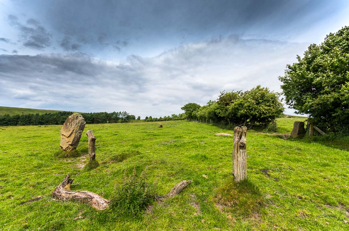
Stone re-used as gatepost (James Elkington)
And thankfully they remain there to this day! Around the same time of Mr Knox’s visit, the Ordnance Survey lads came here too and, in 1854, highlighted the remaining ‘Druidical Stones’ on the first map of the area. But references to the stones from here onwards are sparse and add nothing pertinent to its archaeomythic status. It was a Mr & Mrs Elgee (1930) who were the next to tell us about the site in their exposition on Yorkshire archaeology. They wrote:
“Three large standing stones about 6 feet high on the south-west side of Blakey Topping…are the remains of a circle about 18 yards in diameter. Two or three hollows in the ground indicate the position of other stones, some of which are serving as gateposts nearby. Others have been broken up to help build a wall. These stones are associated with a large settlement sites similar to (one) on Danby Rigg not very far from the imposing Bridestones and approached by an ancient trackway known as the Old Wife’s Trod.”
The general interpretation by the great megalithic archaeologists Aubrey Burl, John Barnatt and their fellow associates, is that these stones are the remains of a stone circle – which seems apt. But of even greater importance seems to be the great hill of Blakey Topping itself, to which this olde ring no doubt related to. Many other prehsitoric sites once scattered this area, but sadly most of them have been destroyed.
References:
Barnatt, John, Stone Circles of Britain (2 volumes), BAR: Oxford 1989.
Burl, Aubrey, A Guide to the Stone Circles of Britain, Ireland and Brittany, New Haven & London 1995.
Burl, Aubrey, The Stone Circles of Britain, Ireland and Brittany, Yale University Press 2000.
Elgee, F., Early Man in Northeast Yorkshire, Frank Bellows: Gloucester 1930.
Elgee, F. & H.W., The Archaeology of Yorkshire, Methuen: London 1933.
Gutch, Mrs E., Examples of Printed Folklore Concerning the North Riding of Yorkshire, David Nutt: London 1899.
Acknowledgements: Big thanks to the photographer James Elkington, for use of his photos in this profile. Cheers mate. Also, accreditation of early OS-map usage, reproduced with the permission of the National Library of Scotland.
Standing Stone (missing): OS Grid Reference – SE 881 947
Archaeology & History
A number of standing stones were reported by regional historian Robert Knox (1855) in his antiquarian work of this area, but forestry and vandalism has seen the demise of some. This one, however, may possibly still be found, laid down somewhere on the tops, along the ridge aptly-named as Stone Hill Head. Where precisely it might be, we know not—but one of you Yorkshire antiquarian ramblers might be able to find and resurrect it by following old Mr Knox’s notes. Writing extensively of the ancient remains around nearby Blakey Topping this is what he told us of the Stone Hill Head monolith:
“The pillar…standing erect, is five and a half feet high, three broad, and from ten inches to two feet thick. This is much corroded either by natural decomposition, or designedly made so by manual labour; some of the holes in it being circular, as if intended to fit the heads of human beings into them, at the time of their immolation, while laid prostrate on the ground… This stone stands northeast from Blakey Topping, distant about six furlongs, and is the furthest pillar in this collection from that hill.”
If the real explorers amongst you manage to rediscover the stone, please let us know.
References:
Knox, Robert, Descriptions Geological, Topographical and Antiquarian in Eastern Yorkshire, London 1855.
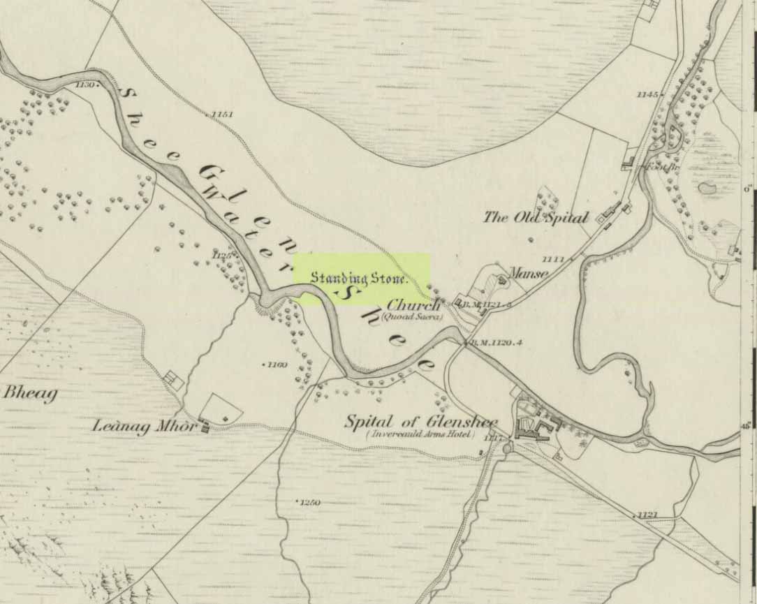
Take to A93 road, north, between Blairgowrie and Braemar, keeping your eyes peeled many miles on, to turn left along the minor road as you approach the tiny Spittal of Glenshee hamlet. Just as you go over the ancient bridge, park up on your left, below the church. Walk round the back of the church and you’ll see a large tree-covered mound. Walk onto its top.
Archaeology & History
Stone marked on 1862 map
This quiet, almost hidden, six-foot tall standing stone on what initially seems to be a large fairy mound or tumulus at the back of the rude church, has been occluded from general view (in my opinion, deliberately) by the construction of the more debased christian edifice right in front of it. But it detracts not from its gentle majesty once you reach its ancient body, atop of the old hill.
The stone is one in a cluster of prehistoric sites in and around this Glen of the Fairy Folk (as its name tells), where the rivers Shee and Beag converge. If the church didn’t obstruct the view, some of the other sites would have been visible from here.
Folklore
The old stone, looking east
Folklore tells that when the christians came into the Glen to build a church—initially a half-mile or so to the east—the little people were much annoyed at the actions of the incomers, as it intruded on one of their sacred rings of stone close by. By night they came out, and every stone that had been laid by the christians in the day was removed. Each day the insensitive christians came and built their church without asking, and each night the little people removed it. Eventually an agreement was made, and the fairies let them build the church next to this standing stone. So goes the tale….
A veritable cluster of stories about Fingal, Ossian, Dermid and Grianne scatter this area, with many of them relating to ancient sites, but I’ve not found one directly relating to this stone.
References:
Miller, T.D., Tales of a Highland Parish, Munro Press: Perth 1929.
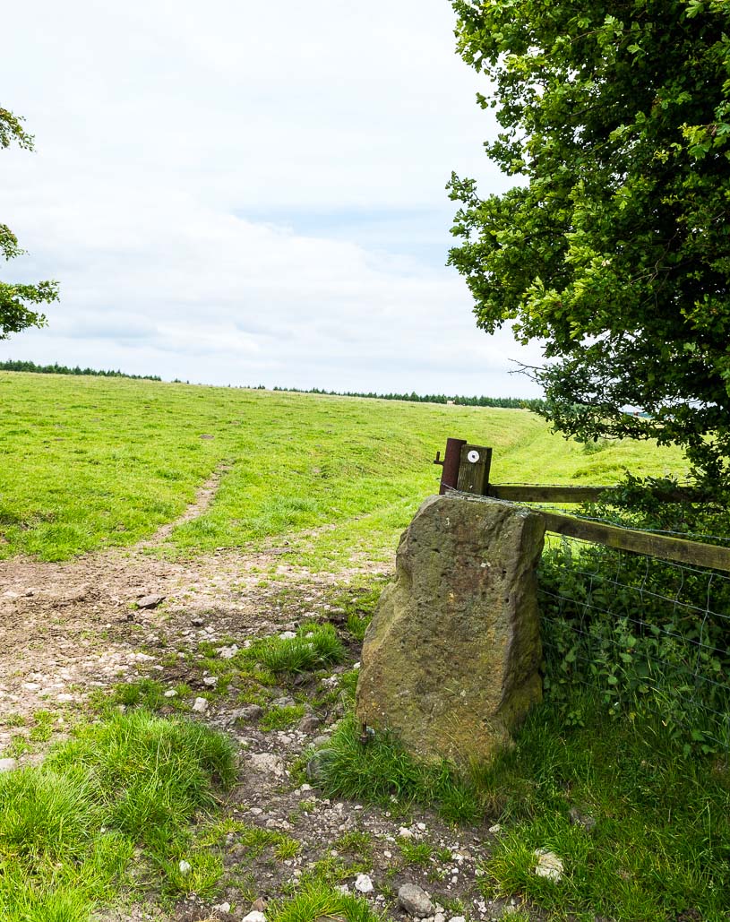
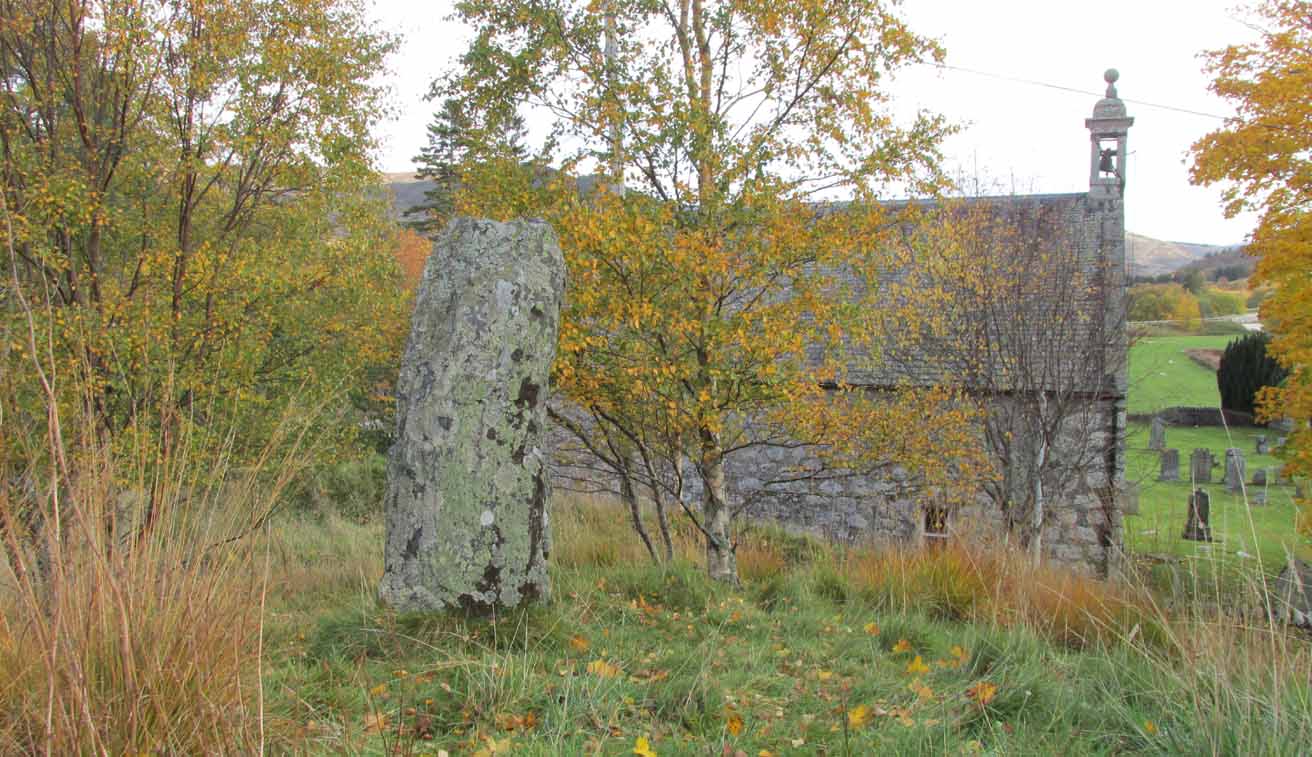
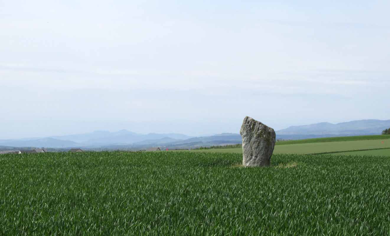
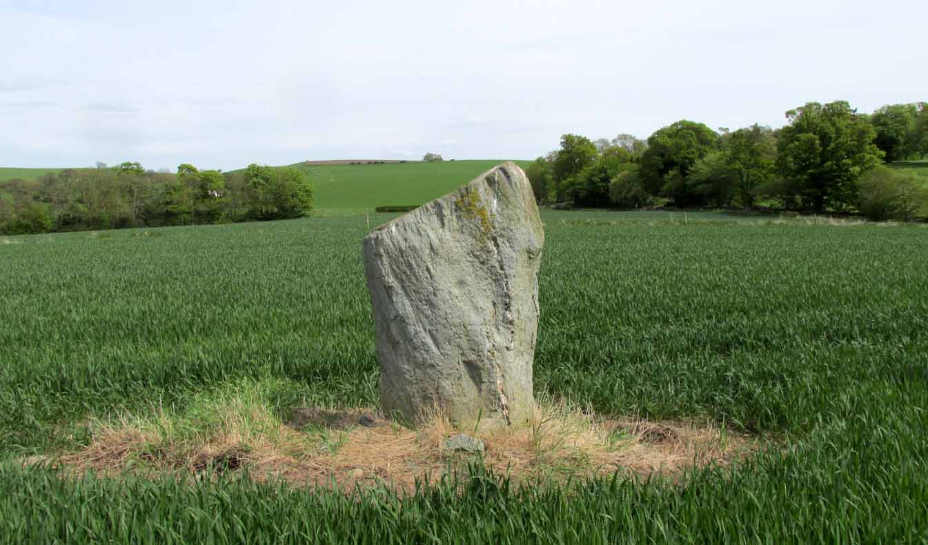
On the main road (A94) through Scone, go east along either Murrayshall Road or Bonhard Road for a short distance until you go out of the town and into the countryside. About ⅓-mile (0.5km) along the country lane, go left at the road junction; and just another ¼-mile on, notice the field-gate on your left. As you’ll see, the standing stone is just over 100 yards away in that field.
Archaeology & History
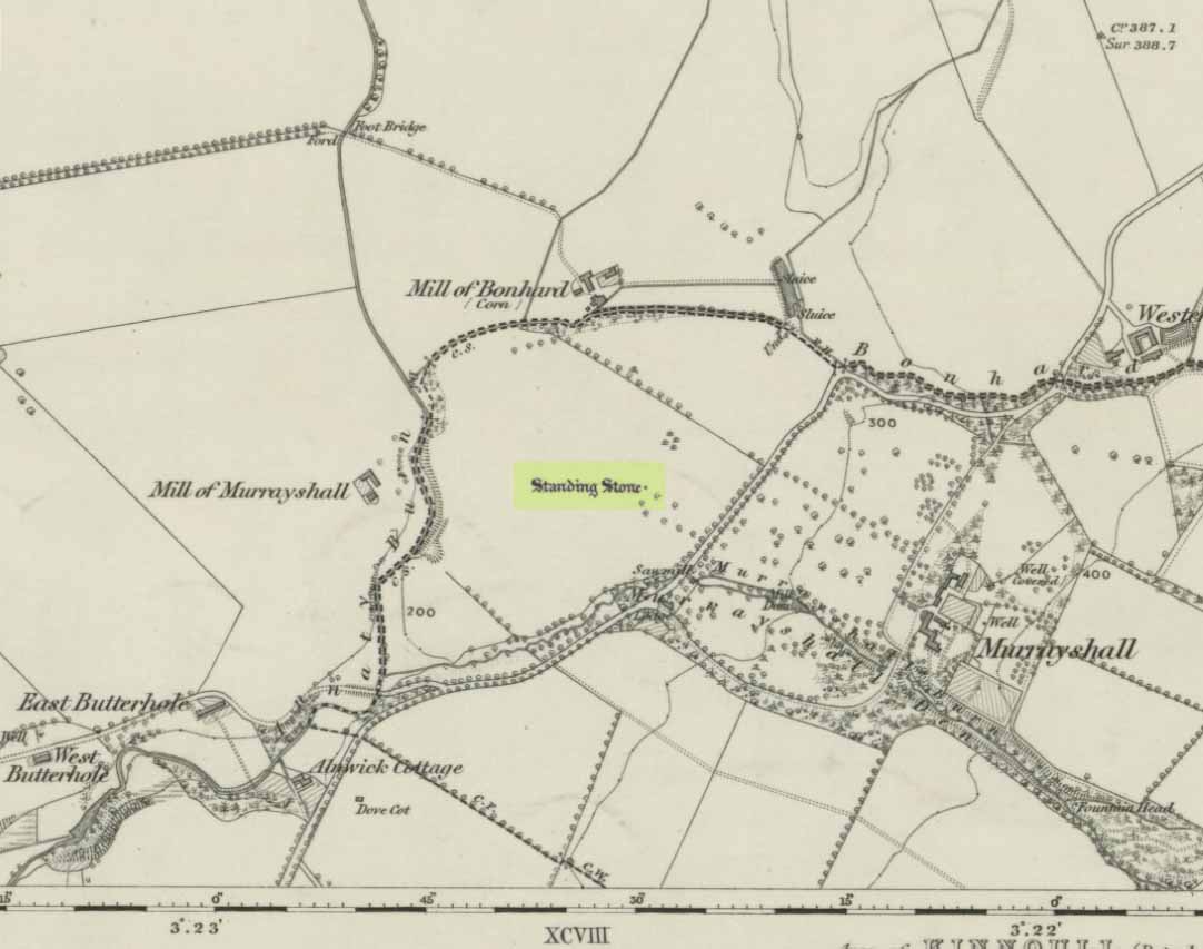
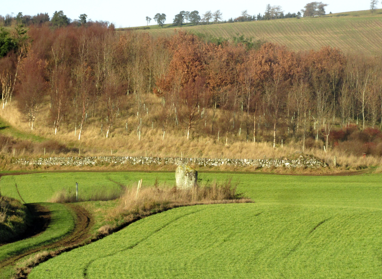
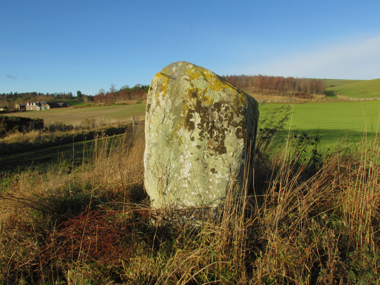
Murrayshall on 1867 map
In a region littered with megaliths, this fine upright single stone stands, quite deliberately, at a point in the field where you have excellent 360° views, which to the north looks way into the orgasm of the Scottish mountains. History and tradition seem to tell it has always been a loner, without companions, but no archaeological excavation has taken place here to my knowledge; and the apparent proximity of some type of prehistoric ring-ditch 30 yards away may be related to the stone. But we don’t for sure…
Close-up of cupmark
North-face with cupmark
Despite being shown on the first OS-map of the region in 1867 and despite being a large monolith more than 6 feet tall, very little seems to have been said of it. It was included in Swarbrick’s (2012) poorly arranged survey; and the Royal Commission (1994) merely listed it, without comment, other than to say “it bears no markings.” Yet when Paul Hornby and I visited the place recently, a large single cup-mark is plain to see on the north-face of the stone.
Although the stone is alone in this field, once you start exploring the hills a short distance to the south and the farmed fields heading north and east, masses of prehistoric sites begin to appear. It’s well worth checking out!
References:
Royal Commission on the Ancient & Historical Monuments of Scotland, South-East Perth: An Archaeological Landscape, HMSO: Edinburgh 1994.
Swarbrick, Olaf, A Gazetteer of Prehistoric Standing Stones in Great Britain, BAR: Oxford 2012.
Acknowledgements: Huge thanks as always to Paul Hornby for getting us to this site. Plus, accreditation of early OS-map usage is reproduced with the permission of the National Library of Scotland.
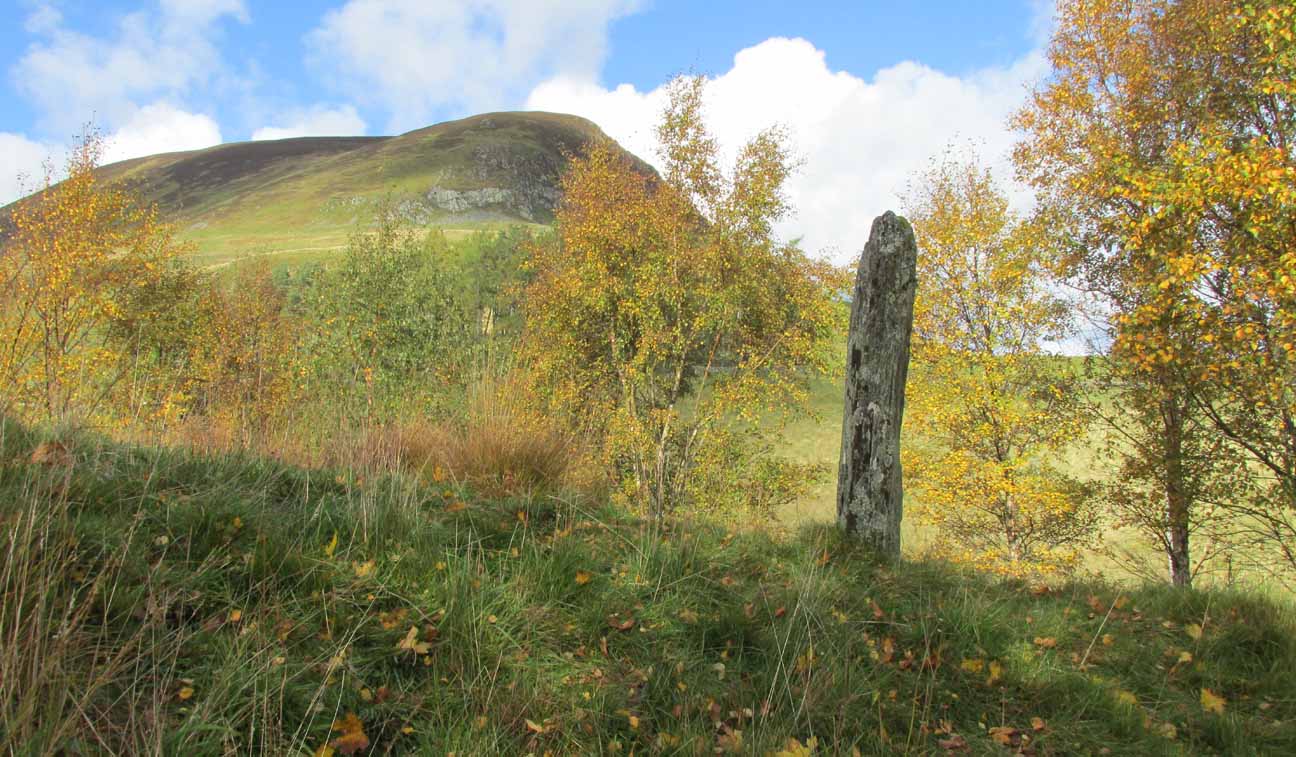
Along the A822 road between Dunkeld and Milton, 4.7 miles (7.6km) west of the A9, turn left down the track signposted ‘Meikle Findowie’. About 700 yards along the track you’ll reach a modernised farmhouse and here, on your left, a track takes you eastwards (left). Go along here for about 100 yards until, just before the modernised house on your right (it was just a pile of ruins when we came here), you’ll see the standing stone in front of it.
Archaeology & History
Looking westwards
Beside the old trackway that runs east-west past Meikle Findowie, above the ancient flood-plain of the breathing River Braan, a solitary stone lives by the more modern shadow of old sheep-folds. Tis a quiet little fella, less than 5 feet tall, that you could almost pass as a forgotten gatepost if you chattered when walking by. But it’s much more ancient than any old gate…
It nestles below the old hill of Airlich, with its beautiful stone circle and huge ancient enclosures higher up: a chunky old stone with no carvings or other human marks upon it. Tis a site site worth visiting before heading uphill, to the megalithic ring of enchantment.
Acknowledgements: Huge thanks as always to Paul Hornby for getting us to this site.
Just less than a mile east of Blairgowrie, the site is situated about 200 yards along a farm track that runs north from the A926 Rattray – Alyth Road. This road is narrow with a lot of bends and very busy, with no safe parking places. It is best to walk from Rattray, the stone will be seen in the field just east of Drumend Farm.
Archaeology & History
There is one stone here that survives from a megalithic ring that was progressively destroyed some time between the publication of the 1792 Old Statistical Account and the publication of the 1867 OS map. Reverend James Smith, writing in the 1792 Statistical Account, told us:
“Above the river, SE from the village, in a beautiful situation, is a Druidical temple, much defaced, and many of the stones carried off. The farm upon which it has been built, is called Standing Stones.”
Reverend William Herdman wrote patronisingly in the 1845 New Statistical Account:
“If large graystones be entitled to the appellation of antiquities, or are any indication of the religious worship of our ancestors, a few of these appear in a field, thence called Standing Stanes, which are supposed to be the ruins of a Druidical Temple.”
Many years later, in the first few years of the 20th century, the great northern antiquarian and megalith writer, Fred Coles, visited the site and gave this description in 1909:
“Standing Stone on the Farm of Standing Stone, Old Rattray. [A] monolith attracts our notice, in a field on the north of the main road, one mile and a quarter east of the middle of Old Rattray village. The height above sea-level is 270 feet. This monolith …[has a] mineralogical composition …more analogous to the quartziferous schists so frequently found in the vicinity.
The top is smooth, with an inclination towards the south-east, and the whole mass is squarish and pillar-like. It is set up with the longer axis N.E. 50° and S.W. 50°. The highest point is 5 feet 1 inch above ground, the basal girth 8 feet, but rather more than mid-way up it increases to 10 feet 4 inches.
In this lower-lying district, comprising an area of about 35 square miles, the megalithic remains are extremely sparse. Agricultural operations, doubtless, have swept away some monoliths, and possibly also whole circles of stones; but at any rate it is somewhat significant that only four Standing Stones are now left, and that there is no record on the maps of any other variety of sepulchral structure.”
This brave survivor has a commanding position over the valley of the River Ericht, and again we can only lament the loss of its companions, but be thankful it too didn’t fall prey to ‘agricultural improvements’ or religious bigotry.
References:
Smith, Rev.James, Old Statistical Account, Perthshire, Parish of Rattray, 1792. #
Herdman, Rev. William, New Statistical Account, Perthshire, Parish of Rattray, 1845.
Coles F.R., ‘Report on stone circles surveyed in Perthshire (South-East District), with measured plans and drawings; obtained under the Gunning Fellowship’, Proc. Soc. Antiq. Scot., vol. 43, 1908-9.
Standing Stones (destroyed): OS Grid Reference — NO 4128 1769
Also Known as:
Dairsie Stones
Archaeology & History
View of the field where the stones stood (Paul Hornby)
Recent archaeological investigations at the site which has become known as the Dairsie Hoard—where many pieces of broken Roman silverware were seemingly deposited in one spot, adjacent to a dried bog “which may arise from a former spring” of water—brought about the discovery of much earlier megalithic remains. The position of two previously unrecorded standing stones were found during the archaeological dig here. In the most recent edition of Current Archaeology, Fraser Hunter (2018) described the position of the Roman silverware close to some ancient pits or sockets in the ground. This “group of features was…intriguing”, he told,
“for two of them contained stumps of standing stones, one in association with probably Bronze Age pottery. This hoard had been buried in a memorable, perhaps even a sacred site, between an intriguing wet spot on one side and, on the other, two standing stones, which were already ancient by the time the silver was buried. Such burial of valuables in association with prehistoric monuments can be readily paralleled elsewhere. It suggests this silver was placed under the care of the gods, probably as a sacrifice rather than a burial for safekeeping.”
Two thousand years before the Roman silver deposit had been deposited, megaliths here stood. Sadly they’re long gone, leaving more questions than answers as usual…
References:
Hunter, Fraser, “Solving a Silver Jigsaw,” in Current Archaeology, 335, February 2018.
Acknowledgments: Many thanks to Paul Hornby for use of his photo in this site profile.