From Masham, take the Fearby Road to the village, keep going on the same road through Healey village and less than a mile on where the road forks, bear to the right past and go along the gorgeous little-known vale of Colsterdale. It’s bloody beautiful! Less than 2 miles on, walk up the notable track veering to your right, diagonally uphill. Walk along till you get to the moor edge. Go thru the gate and follow the swerving uphill path to the bottom of Slipstone Crags. Once you level out at the Crags top, look across the small valley to your left and, on t’other side, you’ll notice a standing stone upright in the heather, just 100 yards on the flat on the other side of the valley. Head right for it!
Archaeology & History
Looking west
There are no known written references to this standing stone, which we visited for the first time yesterday, in a brief wander to the nearby Agra Woods cup-and-ring stones a few hundred yards southeast. The monolith stands some four-and-half-feet tall and, at its base, is more than three feet broad and just one foot wide. Just to its side and almost completely covered in peat and vegetation is what may have been another once-upright companion asleep in the Earth. Another possibly fallen stone is less than 10 yards west. The upright stands on the flat moorland overlooking the confluence of two (once) fast-flowing waters of Brown Beck and Birk Gill; and the landscape that reaches out from here is something to behold!
We found the remains of other old monuments on the moor, but some were obviously related to the industrial mining not far away. However, two or three other small upright stones and a large stone circular structure were also located which very obviously predated any industrial or medieval workings. We need to revisit this moorland and spend more time exploring to see what other things are hidden, lost midst the peat and heather.
Pretty easy to find. At the eastern end of Loch Tay, go through the old village of Kenmore along the A827, towards Aberfeldy, for about a mile. At least a mile past Kenmore, keep your eyes peeled for a small left turn which takes you back into the grounds of Taymouth Castle. Go on this small road, pass the ornate walling, and you’ll see these two standing stones in front of you, before the trees, on the left. If you reach the Croftmoraig Stone Circle, you’ve gone a few hundred yards past the turning.
Archaeology & History
Fred Coles’ drawing & lay-out
These fine-looking standing stones a mile northeast of Kenmore village, on the edge of the grounds of the superb Taymouth Castle, are worthy old monoliths, encrusted by the lichens of many centuries, resting within the long grass beside the track that runs to the castle. But they have received little attention in archaeological terms. When Fred Coles (1910) described them, he thought them to be the remains of a stone circle — an impression echoed by Margaret Stewart (1966) many years later (I got the same impression aswell), but no other stones have been found to substantiate this (although Mr Gillies’ folklore remnant is intriguing). There is a notable rounded hillock immediately behind the two stones which may, or may not, have had other uprights surrounding it; though I can find no further data anywhere to substantiate such a thing.
In William Gillies’ (1938) historical survey of the area he related Mr Coles’ earlier findings of the two stones, telling us:
“There are two great standing stones just within the Principal Gate leading to Taymouth Castle. The stone A (see plan) stands at a distance of 54 feet to the NNW of B — a somewhat greater diameter than is common among the Perthshire Circles. These stones are almost equal in height — A is 4ft 9in, B is 4ft 7in — and they are both rugged blocks of a rough species of diorite. Stone A measures round the base 10ft 8in, and stone B 14ft.”
The western stoneThe eastern stone
But it seems that little else has been found about the place. It’s in a gorgeous setting (but, round here, everything’s in a gorgeous setting!) and must have related to other sites in the area, but it’s hard to contextualize the place on a single visit. If you stand behind the two stones, the shape of their ‘heads’ fits very nicely onto the rounded hillock on the northwestern skyline — which seems to have later been used as a hillfort. Whether this has any astronomical potential, I aint checked. (though Thom says nothing about them)
In geomantic terms both of these stones possess a distinct female flavour to them; the easternmost thinner of the two, particularly so. But then I could just be talking bullshit! I’d have loved to have spent more time with these two stones — bimbling, sitting, focussing, dreaming — as people of olde naturally did; but we were on the move and had other places to see. Tis a delightful spot indeed…
(NOTE – This site was first given a grid reference of NN 801 477 in Margaret Stewart’s (1967) fine essay on the standing stones at nearby Lundin; and the grid-ref has since been reproduced in texts by Burl (1993), Thom (1990) and others. Please note that this grid-ref is incorrect and is nearly a mile away from the actual position of the stones.)
Easternmost stone from another angle
Folklore
There is the possibility that this site once played a part in an important megalithic stone row. Mr Gillies (1938) once again notes an old tradition told by local people which “says that at one time there was a paved way connecting the circle, of which these stones are the remains, with the great Croftmoraig circle.” Very intriguing indeed…
References:
Burl, Aubrey, From Carnac to Callanish, Yale University Press 1993.
This one’s easy as it’s right by the roadside, so making it dead easy for those lazy ones amongst you who don’t like walking! You can find it just past the turn-off (signed) for Acharn Lodge, a few hundred yards along the A827 road (off the A85 by the garage) from Lix Toll, less than a mile before reaching Killin.
Archaeology & History
This solitary standing stone, not much more than about three feet tall, originally stood in the adjacent field and was moved to the edge of the road sometime ago. It was described briefly in William Gillies’ Breadalbane (1938) where he said, “Its height is 3 feet 10 inches and its girth at the base 6 feet 2 inches… This solitary stone is possibly the sole survivor of a group that once formed a circle,” though gives no more information to support this idea. It seems more likely that the stone accompanied a cairn, that was levelled by farming sometime in the 19th century.
References:
Gillies, William A., In Famed Breadalbane, Munro Press: Perth 1938.
To get to the monolith travel along the B1253 road to the west of Bridlington for about 5 miles or from York take the A166 in an easterly direction then onto the B1251 and at Fridaythorpe take the B1253 east again toward Bridlington. The huge stone cannot be missed from the road and from the surrounding area. It stands within the graveyard of All Saints’ church at the north-eastern side of Rudston village.
Archaeology & History
Located in the graveyard of All Saints’ church, this huge and mighty monolith or menhir stands at 25 foot 9 inches high (7.7 metres), and is the tallest prehistoric standing stone in Britain. It is estimated to weigh 40 tons, and it is thought to be the same in height below ground as what it is above the ground, though I don’t know whether anyone has ever checked that theory out. It probably dates from the Bronze-Age about 1,600 BC. Because of vandalism and erosion the top of the stone now has a lead cap, so it is said the stone could have originally been 28 feet high. So where has the top part gone to, I wonder. We are told that the stone was dragged, or rolled on logs, all the way from an outcrop at Cayton Bay some 10 miles as the crow flies to the north.
Rudston monolith stands at the end of at least one cursus monument on an old prehistoric alignment (see the Rudston B Cursus entry). It would appear to have played an important ingredient in a huge ceremonial landscape on the Gypsey Race. Also in the churchyard (north-east corner) there is a large slab-stone cist which was removed from a nearby round barrow and also a gritstone. At Breeze Farm about one mile to the south-west of the village is the site of a Roman villa.
Folklore
The folklore elements tell us that this is, in fact, a phallic stone and in pagan times some form of ritual was held around the monolith, but then the Christian church was built around it in the Dark Ages – it was a case of Christianity adopting the pagan religion and allowing the stone to stay where it was, but what else could they do because the stone was to big to move, so a lot of tolerance was in order here. The present church of All Saints’ dates from the Norman period. In any case the stone had stood here for a good 2,000 years or more before any church was established in the village. According to the legend, the devil hurled the huge stone at the first Christian church on the site, but as usual he just missed – doesn’t he always!
References:
Bord, Janet & Colin, Ancient Mysteries of Britain, Diamond Books: London 1991.
Anderton, Bill, Guide To Ancient Britain, Foulsham: London 1991.
Darvill, Timothy, AA Glovebox Guide – Ancient Britain, AA Publishing Division: Basingstoke 1988.
Royston, Peter, Rudston: A Sketch of its History and Antiquities, George Furby: Bridlington 1873.
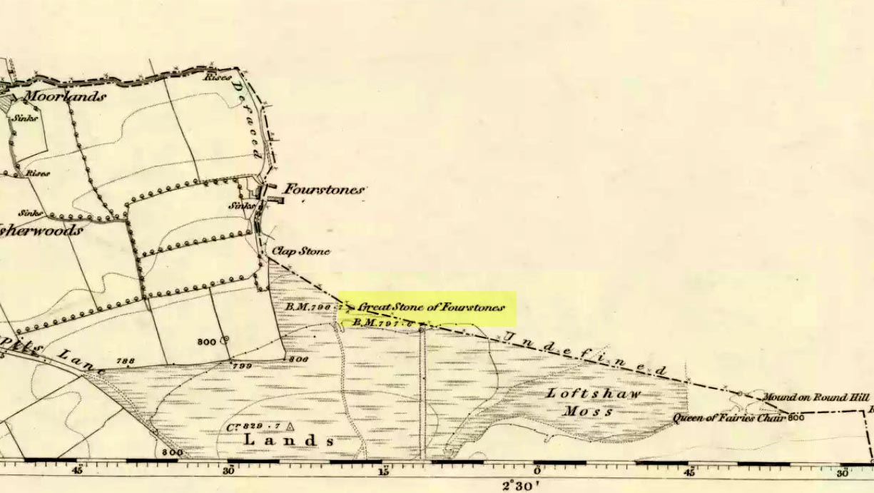
From near the middle of the large village (or small town!) of High Bentham, go down Station Road, over the river — where the road becomes known as Thickrash Brow! — and keep going for about a mile. The landscape opens up into the hills and there, on the left-hand side of the road, is a car-parking spot with a footpath taking you straight up to the large boulder a 100 yards on: that’s our Great Stone! You can’t really miss it.
Archaeology & History
Great Stone on 1847 map
A meeting place of local tribes in more ancient days, the moorland plain upon which the Great Stone sits, beckons to a vast landscape on all quarters (north, south, east and west) calling the elders from their lands for annual rites and decisions to befit the health of the land and the people. The stone rests on the ancient boundary of Yorkshire and Lancashire, just on the Yorkshire side, and was visited annually in more later centuries during the beating of the bounds, to define the edges of the local township.
Graffiti & cup-marks on the top
First described in a Yorkshire inquisition account from 1307, this Big Stone was visited by Harry Speight (1892) who described it as measuring 30 feet round and 12 feet high. I came here for the first time in the 1980s when I was hitch-hiking into the Scottish mountains, but a good old “local” (from the Yorkshire side) took a detour to show me the place! Once here, I climbed up the very worn “steps” which were carved into the side of the boulder several centuries back and it didn’t surprise me to find a number of cup-markings (no discernible rings) on its top surface. When I came here again with Michala Potts and Paul Hornby yesterday, I couldn’t believe how many people had carved their names on top of the Great Stone in the intervening years — it’s almost covered in modern graffiti and the old cup-markings were much harder to see. Taylor (1906) mentions them briefly in his holy wells survey, saying how,
“This great boulder is ascended on its eastern side by fourteen steps, and on the top are two circular holes about two inches deep and two inches in diameter.”
There used to be three others boulders very close to this one (hence its title), making a natural stone circle, but they were “broken up for sharpening scythes” a couple of hundred years back. A much wider archaeological survey of this region is long overdue.
Folklore
Great Stone, looking east
Harry Speight (1892) told how the (original) Four Stones were the creation of our old friend the Devil, long ago, who dropped them in one his many megalithic travels across our land. The stones were also the meeting place of ancient councils, from the tribes either side of the Yorkshire-Lancashire border. Their presence here also had mythic relationship with the Queen of the Fairies Chair, about a mile southeast, along the same boundary line.
Weird how folklore changes. Whilst old Mr Speight told how the devil created the once great four stones that were here, many years later Jessica Lofthouse (1976) told how the three missing stones – which had been here “since the world began” – were actually taken from here by Old Nick. Carrying them over the land,
“His load he dropped on Casterton Fell, where the rocks he discarded, the Devil’s Apronful, are still lying around. He selected the most suitable, dressed them and carried them in panniers down to the (River) Lune”
— and built the legendary Devil’s Bridge at Kirkby Lonsdale – which itself has strange tales to tell. Another creation myth about the Great Stone is told on the plaque near the stone, alongside the footpath, which tells:
“Legend has it that it is a small part of the debris hurled by the giant Finn McCool across the Irish Sea in a fit of anger.”
It’s very obvious that a lotta mythic landscape material has been neglected and overlooked around this site. Something we need to remedy, if we can, in the coming years…
References:
Lofthouse, J., North Country Folklore, Hale: London 1976.
Speight, Harry, The Craven and Northwest Yorkshire Highlands, Elliott Stock: London 1892.
Taylor, Henry, The Ancient Crosses and Holy Wells of Lancashire, Sherratt & Hughes: Manchester 1906.
From Gilmerton village, take the A822 Dunkeld road north. Go for about 200 yards and take the little road to Monzie; watching carefully another 200 yards on for the dirt-track on the left taking you across the fields. Go along the track, watching out for the small stones in the field on your right less than 200 yards along. You can’t really miss ’em! This small ring of stones is the Monzie Cairn Circle. The carving is just in front of it!
Archaeology & History
Although we know this brilliant carved stone has some relationship with the Monzie cairn circle only five yards away (it was linked via a man-made stone causeway, running between the circle and the carving), the stone itself is very much deserving of its own entry here — and at the same time I can give Andrew Finlayson’s (2010) excellent book a decent plug aswell! (the superb drawings of the stone, top & bottom, are from Andy’s work)
Allen’s 1882 drawingCarving & proximity of circle
First mentioned (I think) in Simpson’s (1867) early survey, the carving was described soon after by J. Romilly Allen (1882), who gave us an early drawing of the stone. Thought by some to have originally stood upright, the carving was described by Aubrey Burl (2000) as being, “decorated with forty-six cupmarks, cup-and-rings, nine double, one triple, there are grooves and a pair of joined cups.” It’s certainly an impressive carving!
Although the carving has been posited by some archaeologists as an outlier to the Monzie circle, it’s probable that the circle emerged from the carving — a concept that some may find difficult to understand. I’m not aware of any modern excavations here (the last, I think, was in 1938), but my guess would be that the stone causeway laid between the cup-and-ring stone and the circle ran towards the circle from the carving, and not the other way round. The carving is probably older than the stone ring — though of course, without excavation, my idea could be utter bullshit! (there are also some cup-marked stones in the circle aswell – though none as impressive as this)
One of my truly favourite megalith fanatics (despite some of his alignments being out), Alexander Thom, came here and thought this old carving “coincided with a rough stellar alignment from the centre-point of the cairn” (Hadingham 1974); though his notes in Megalithic Rings (1980) tell that,
“from the cupmarked stone beside the circle, the midsummer sun sets above an outlier some 800ft distant.”
The “outlier” that Thom mentions is known as the Witches’ Stone of Monzie, which Simpson (1867) appears to have mistakenly thought was the name of this very carving.
References:
Allen, J. Romilly, “Notes on some Undescribed Stones with Cup Markings in Scotland,” in Proceedings of the Society of Antiquaries Scotland, volume 16, 1882.
Burl, Aubrey, The Stone Circles of Britain, Ireland and Brittany, Yale University Press 2000.
Finlayson, Andrew, The Stones of Strathearn, One Tree Island: Comrie 2010.
Hadingham, Evan, Ancient Carvings in Britain, Garnstone: London 1974.
Simpson, James, Archaic Sculpturings of Cups, Circles, etc., Upon Stones and Rocks in Scotland, England and other Countries, Edmonston & Douglas: Edinburgh 1867.
Thom, Alexander, “Megalithic Astronomy: Indications in Standing Stones,” in Vistas in Astronomy, volume 7, 1966.
Thom, A., Thom, A.S. & Burl, H.A.W., Megalithic Rings, BAR: Oxford 1980.
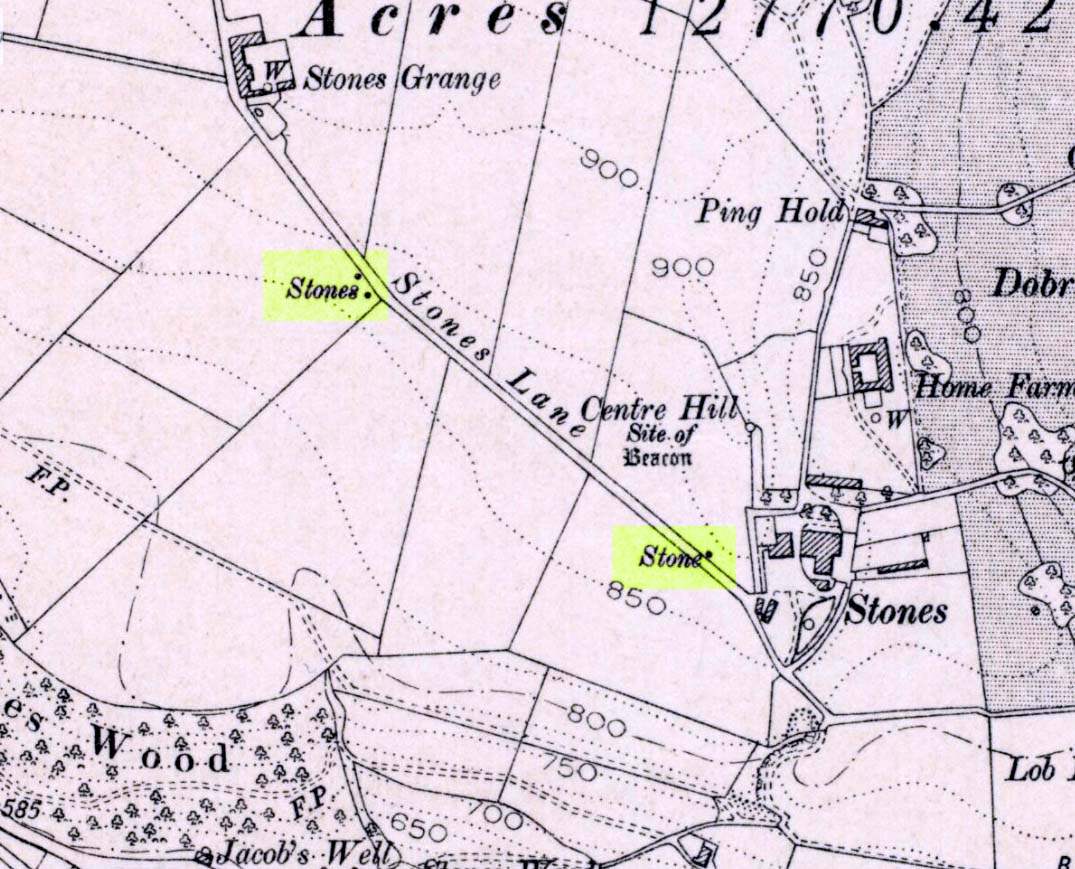
If you wanna drive here, be prepared for a long uphill winding haul, with very poor turning, single-track roads and no parking spots. It’s dodgy as hell! But, if y’ must – from the central roundabout in Todmorden, take the road diagonally across as if you’re going to the train station, and barely 50 yards up, take the right turn under the railways arches, bearing sharp left, then up the very steep zigzagging dangerous road for a mile or so. You’ll eventually reach Stones Lane on your left. Go down this, nearly to the end, slowly – and keep your eyes peeled until you see the big one! You can’t miss it! If you want walk up (a much safer, healthier and preferable route), take the Calderdale Way route up past Dobroyd Castle, and where you get to the top of the hill and the fields open up ahead of you, look down the slope into the field for one stone, and up past the shrubs to Centre Hill. You can’t miss them!
Archaeology & History
Three ‘stones’ on 1911 map
This is a quite extraordinary sight to those who visit here for the first time. Moreso because, until very recently, the place was excluded from all text-books and surveys. But if you like your megaliths, this place is well worth the trek up the hill. You’ll be amazed! The tallest and largest of these giant monoliths was recorded when a team from Ordnance Survey mapped the area in 1844, but gave no antiquated note to it. When another Ordnance Survey team re-surveyed the area again in 1911, they noted two other ‘stones’ three fields away to the northeast. More than a decade later, the industrialist historian Abraham Newall (1925) described them at some length in his fine work on the region.
Stone 1, looking NWStone 2, at top of hillock (soz about the crap picture)
The first thing generally noticed is the 12-foot tall standing stone near the bottom of the field (stone 1). Then you’ll see the curiously-worked thin standing stone, nearly as tall, on the hillock at the top of the same field (stone 2). This stone has been surmounted onto an old millstone and the hillock itself was once an old beacon hill. Then on the other side of the road a few hundred yards along, another stone just over 4-feet tall can be seen (stone 3); and in the same field is another one laid down at the side of a well (stone 4). This stone used to stand just where the water appears. It’s seems probable that other standing stones may once have been in close attendance, but have been destroyed over time.
Stone 3, looking southStone 3, looking west
Stone 1 is hemmed in at the base by several stones, giving the impression that it was resurrected at some time in the recent past. Several local stories attest to this. Stone 2 was once further down in the same field but was moved to its present position in the 19th century and was, it is alleged, moved there to commemorate the Battle of Waterloo. Several local historians contest this. Stone 3 has nothing said of it; apart from by the local farmer who said it once had a companion (as illustrated on the early map, above). We were told that this companion (stone 4) was uprooted and a spring of water appeared where it stood, so they laid it down in the position it still occupies, just by the spring 10 yards into the field.
If you’re into megaliths and live in Yorkshire or Lancashire, check these beauties out! Just respect the local farmer – he’s not into ignorant tourists clambering over walls. (don’t say you’ve not been warned!)
References:
Bennett, Paul, The Old Stones of Elmet, Capall Bann: Milverton 2001.
Newell, Abraham, A Hillside View of Industrial History, J. Bentley: Todmorden 1925.
Standing Stone (destroyed): OS Grid Reference – TA 040 587
Archaeology & History
Information on this stone is sparse and the grid-reference cited is a close approximation of its precise location. And were it not for the records of Victorian folklorists, its existence may have been completely lost. The first reference I’ve found of it is in Nicholson’s East Yorkshire (1890) survey, but I am hoping that someone, somewhere, made archaeological notes of the site (am I hoping for too much here…?) The stone appears to have stood upon, or was very close to, the local boundary line between Nafferton and Driffield—which means there could be a record of it in any perambulation accounts of the region.
Folklore
John Nicholson (1890) told us the following intriguing bitta folklore about this stone, saying:
“About half way down the hill forming the eastern slope of Nafferton Slack, by the roadside, to prevent waggons leaving the roadway, stood a large stone, which was believed to have wonderful powers. At night, at certain seasons, it glowed like fire, sometimes it seemed but the portal of a well-lighted hall; and one old stone-breaker declared he had heard wonderful music issuing therefrom, the like of which he had never heard before; while on one occasion he had seen troops of gaily-dressed elfins repairing thither, some on foot and some on carriages, and they all went into this mysterious hall. The old man is dead, the stone is gone, and the fairies have departed.”
Some twenty years later, Mrs Gutch repeated the story, but added no further details. One wonders whether the information about a fairy hall implied the former existence of a mound or tumulus next to the old stone (a few hundred yards south, just off the same boundary line, we find the remains of the curiously named tumulus of Cheesecake Hill). Any further info would be most welcome…
References:
Gutch, Mrs E., Examples of Printed Folk-lore Concerning the East Riding of Yorkshire, David Nutt: London 1912.
Nicholson, Folk-lore of East Yorkshire, Simpkin Marshall: London 1890.
Get up to the Aiggin Stone and turn your back to Robin Hood’s Bed and Blackstone Edge, facing (roughly) north. There’s a small path just to the left of the Aiggin Stone, running northwest (don’t take the more pronounced footpath on its right, or you’ll get a bit lost). Walk down this path for about 60-70 yards and you can’t miss it!
Archaeology & History
Initially I thought this was the stone described in James Maxim’s (1965) exploratory study of the ancient route of the Long Causeway, not far from the Aiggin Stone, running up between Littleborough and Sowerby Bridge, across the Yorkshire border — but I quickly realised my error! Maxim’s upright was one of the boundary markers and is a good 100 yards away from this little fella, seemingly divorced from history. But he’s a curiosity that could do with an explanation…
Standing Stone; and Robin Hood’s Bed on horizon
The stone is less than a metre tall but appears to have had been a little taller in earlier days, having the top of it knocked off — either accidentally or otherwise (someone suggested that the small stone on the ground by its side was once the top of the stone). It stands just a yard to the side of an old causeway running from the disused quarries a few hundred yards away, up to the Aiggin Stone. It may have been an old wayside marker stone. It’s certainly old and nobody seems to have said owt about it, so I thought that I’d highlight it here. Any further info on the little fella’s history would be most welcome!
In the heathlands above here we found remains of old walling in the edge of the ancient peat, some of it cutting through into view and some of it still beneath the surface. There wasn’t much of it (though we weren’t here for long), but it looked familiar and old… How old is hard to say at the moment. Who built them? How much more can be found nearby? Were they part of the quarrying operations, or destroyed by them? Anyone know owt more?
References:
Maxim, James L., A Lancashire Lion, J.L. Maxim Trustees: Leeds 1965.
From the lovely village of Summerbridge (near Pateley Bridge), go up the steep Hartwith Bank road, going straight across at the crossroads for another few hundred yards, passing the old tombs of Graffa Plain on your right…and they’ll start appearing on your left-hand side (west). Do not go into the expensive National Trust car-park. Instead (if you’ve already gone too far), about 100 yards before the Car Park you’ll find a small dirt-track on your left a short distance away. But if you drive past the rip-off car park, another 100 yards on there’s another spot where you can easily park up on the right-hand side of the road. Then cross the road and follow y’ nose…
Archaeology & History
The OS grid reference given above is an approximation — for obvious reasons. This is a huge area that’s covered by Britain’s finest natural megalithic features, obviously sculptured by Nature Herself — though many are the historians who sought to give Druids the credit here. God knows how! The area over which these magnificent rock sentinels live covers some 60 acres and is some 1000 feet above sea level. The view from the hill around which the encircling parade of rocks guards is excellent, allowing our eyes to catch focus on the distant lands of Whernside, Simon’s Seat, York Minster, the Cleveland Hills and Kilburn’s white horse. It’s quite a view.
Easternmost Rocking StoneIdol Stone (Godfrey Higgins 1826)
But this tends to be overlooked when you first visit the place, as the rocks which surround and walk alongside you overwhelm with impressions not encountered before. To those with spirit, you’ll be bouncing and running all day here, clambering upon rocking stones, jumping between dodgy gorges that await falls, and just aching to climb pinnacles that deny you. But then, if you need the selfishness of silence, this arena will only grant such solace when the rains are about, or dense fog and low cloud keeps others from this haunting amphitheatre. And it’s not surprising… The mass of rocks contort into the most beautiful and curious simulacra, which would not have gone unnoticed, nor deemed unimportant in the sacred landscape of our ancestors…
Brimham Rocks have been written about since the 17th century, though they didn’t receive the serious attention of outsiders until the 19th, when numerous Victorian writers — from antiquarians and geologists, to archaeologists and Druids — got to hear about the place. And by the beginning of the 20th century, a veritable mass of articles had been written in journals and travelogues of all persuasions! These quiet Yorkshire Rocks had become truly famous!
Brimham Rocks (Walbran 1856)Old Woman and her consort
A lengthy essay was written in the distinguished archaeology journal of its time, Archaeologia, by northern historian Hayman Rooke (1787), who thought that some of the rocks here had been tampered with by the druids; with the legendary Cannon Rock in particular possessing oracular properties. The site as a whole was, he posited, a temple for Druids in ancient days. Certainly the place would have been deemed as sacred, whether by the druids or our more remote neolithic and Bronze Age ancestors.
Harry Speight & his mates, c.1890
In Harry Speight’s magnum opus, Nidderdale (1894), he described these rocky giants as best as he could, admitting as others before and since, that no mere words can convey the impression that only a personal encounter liberates, saying:
“The Brimham Rocks are among the greatest natural wonders of Yorkshire, and many have been the theories from time to time advanced as to the cause of their extraordinary aspects… The resemblances to natural and artificial objects are most striking. There we have the Elephant Rock, the Porpoise Head, the Dancing Bear (a very singular, naturally-shaped specimen), the Boat Rock, showing the bow and stern completely, etc. Then there is the great Idol Rock, a most mysterious-looking object, of almost incredible size and form. It is a perfectly detached block, fully twenty feet high, weathered along face joints into three roughly circular pieces, each from 40 to 50 feet in circumference, piled one above the other; the whole mass, weighing by estimation over 200 tons, being poised on a pyramid 3½ feet in diameter; the pivot itself supporting this immense column having a diameter of barely 12 inches.
“East of the guide’s house are the famous Rocking Stones, consisting of a group of four rocks, which were discovered to be movable in the year 1786. The two on the west side weighing approximately 50 and 25 tons, require but little force to vibrate, while those on the east side, though much smaller are not so well poised and do not move readily. Each of the larger stones has a basin-like cavity on the top, and a kind of knee-hole open to the north, said to be the work of Druids. Close to the Rocking Stones are the appropriately-named Oyster-shell Rock, and the Hippopotamus’ Head. Turning now some thirty yards north of the Idol Rock we ascend Mount Delectable, where is the agreeable Courting or Kissing Chair, happily at not too close quarters with the above Hippopotamus’ Head and Boar’s Snout. The Chair consists of a single seat, but why it should be so called, I had better leave the amorous lover to solve. West of these is the more sober Druid’s Reading Desk, with its church-like lectern on a stout stone base. The we come to the Lover’s Leap, a gigantic and abrupt face of beetling crag, weathered to the west, and rising to a height of 60 to 70 feet, with three immense fragments balanced in a very remarkable manner at the summit. The rock is in tow principal sections, and an iron hand-rail has been fixed across the chasm to enable visitors to look down from the top. Further south are the Frog and Tortoise Rocks, the latter presenting from one point of view a capital resemblance to a tortoise creeping up the face of the crag towards the imaged frog. A little below this is a good imitation of a cannon, projecting from the edge of the cliff. In addition to these singular resemblances there are many others which the guide points out, such as the Yoke of Oxen, Mushroom Rocks, Druid’s Oven, Dog’s Head, Telescope, and the curiously perforated Cannon Rock, etc.”
In a later work, Speight (1906) also mentioned the existence of a Druid’s Circle some 300 yards west of the main natural temples, but this site appears to have been destroyed. Thankfully the large standing stone on Hartwith Moor, a mile to the south, can still be found upright…
Folklore
Idol Stone (Hargrove 1809)
In folklore, there’s little surprise this place was held by just about every 18th and 19th century historian as a ‘druidic site.’ But more interesting – in the light of Paul Devereux’s (2001) work on acoustic archaeology – is what Edmund Bogg (c.1895) said of these huge contorted stones:
“In bygone days these immense stones were supposed to be the habitation of spirits. The echo given from the rocks was said to be the voice of the spirit who dwelt there, and which the people named the Son of the Rocks. From a conversation we had with the peasantry not far from here, it seems the ancient superstition had not yet fully disappeared.”
This is precisely the notion of spirit given to rocky places elsewhere in the world, where the very echo was perceived as the ‘voice of the rocks’. Meditate on it a bit, in situ. (a fine summary of this notion and its implications — which has crept into archaeology of late — can be found in Paul Devereux’s work, Stone Age Soundtracks)
One of Brimham’s southwestern rocks was known as the Noon Stone when Mr Rooke (1787) came here. There are many stones with this name scattering Yorkshire and other northern counties, each with the same mythic background: that the sun casts a shadow from it at midday to indicate the time of day. Of this Noon Stone Mr Hooke also told us that,
“On Midsummer Eve fires are lighted on the side. Its situation is apposite for this purpose, being on the edge of a hill, commanding an extensive view. This custom is of the most remote antiquity.”
On the very southern edge of Brimham’s Rocks (some might say beyond their real border) is the Beacon Rock — and it is aptly named: as in the year 1887 on the day of Queen Victoria’s Jubilee, a great beacon fire was lit here, signalling to others in the distance. Its title however, pre-dates Victoria’s Jubilee, though we don’t know how far back in time it goes…
…to be continued…
References:
Bogg, Edmund, From Eden Vale to the Plains of York, James Miles: Leeds c.1895.
Devereux, Paul, Stone Age Soundtracks: The Acoustic Archaeology of Ancient Sites, Vega: London 2001.
Grainge, William, The History and Topography of Harrogate and the Forest of Knaresborough, John Russell Smith: London 1871.
Harrison, William, A Descriptive Account of Brimham Rocks in the West Riding of Yorkshire, A. Johnson: Ripon 1846.
Michell, John, The Earth Spirit: Its Ways, Shrines and Mysteries, Thames & Hudson: London 1975.
Michell, John, Simulacra, Thames & Hudson: London 1979.
Rooke, Hayman, “Some Account of the Brimham Rocks in Yorkshire,” in Archaeologia journal, volume 8, 1787.
Speight, Harry, Nidderdale and the Garden of the Nidd, Elliot Stock: London 1894.
Speight, Harry, Upper Nidderdale, with the Forest of Knaresborough, Elliot Stock: London 1906.
Walbran, John Richard, A Guide to Ripon, Fountains Abbey, Harrogate, Bolton Abbey, etc, Johnson: Ripon 1856.


")


 sm")


")


")