Cup-and-Ring Stone: OS Grid Reference – NT 499 403
Archaeology & History
The Scottish Royal Commission reported how,
“in 1936 a cup-marked boulder measuring 3ft 10in in length, 3ft 8in width and 1ft 8in in thickness, was found in a cultivated field half a mile southeast of Hawksnest and 75 yards north of the road from Hawksnest to Ladhopemoor.”
The carved stone had been scarred a little by the plough, but had “23 shallow cup-marks on its upper surface varying from 1in to 1.75in diameter.” This carving is curiously omitted from Ronald Morris’ Prehistoric Rock Art of Southern Scotland (1981), so perhaps the carving has been lost. Does anyone know owt more about it?
References:
Royal Commission on the Ancient & Historical Monuments of Scotland, Roxburghshire – volume 2, HMSO: Edinburgh 1956.
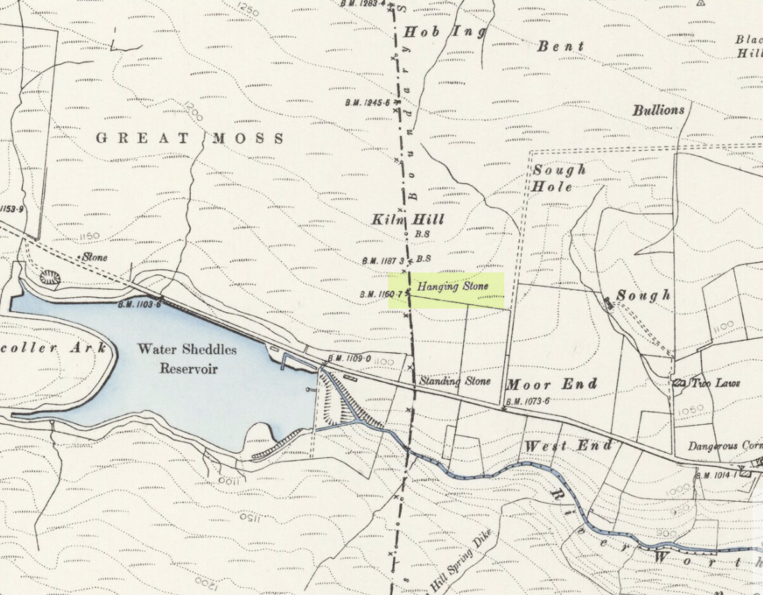
Pretty easy to find. Go along the Oakworth-Wycoller road, between Keighley and Colne, high up on the moors. When you get to the Water Sheddles Reservoir right by the roadside (y’ can’t miss it), stop! On the other side of the road walk onto the moor, heading for the walling a coupla hundred yards to your east (right). Where the corner edge of the walling ends, your standing stone is right in front of you! If for some reason you can’t see it, wander about – though beware the very boggy ground all round here.
Archaeology & History
This seven-foot tall monolith, leaning to one side thanks to the regularly water-logged peat beneath its feet, stands on the Yorkshire-Lancashire. It is locally known as the Hanging Stone and the Standing Stone, but the name ‘Water Sheddles’ is a bittova puzzle. The place-names authority, A.H. Smith (1961) thinks it may derive from the middle-english word, shadel, being a ‘parting of the waters’ – which is pretty good in terms of its position in the landscape and the boggy situation around it. But ‘sheddle’ was also a well-used local dialect word, though it had several meanings and it’s difficult to say whether any of them would apply to this old stone. Invariably relating to pedlars, swindling or dodgy dealings, it was also used to mean a singer, or someone who rang bells, or a schedule, aswell as to shuffle when walking. Perhaps one or more of these meanings tells of events that might have secretly have been done here by local people, but no records say as such — so for the time being I’ll stick with Mr Smith’s interpretation of the word! Up until the year 1618 it was known simply as just a ‘standing stone’, when it seems that the words “Hanging Stone or Water Sheddles Cross” were thereafter carved on its west-face, as the photo below shows.
Cross carved on top of the stoneThe old stone, with its names carved for all to see
Whether or not this stone is prehistoric has been open to conjecture from various quarter over the years. Is it not just an old boundary stone, erected in early medieval times? Or perhaps a primitive christian relic? Certainly the stone was referred to as “le Waterschedles crosse”, as well as “crucem”, in an early record describing the boundaries of the parish of Whalley, dating from around the 15th century. This has led some historians to think that the monolith we see today is simply a primitive cross. However, sticking crosses on moortops or along old boundaries tended to be a policy which the Church adopted as a means to ‘convert’ or christianize the more ancient heathen sites. It seems probable in this case that an old wooden cross represented the ‘crucem‘ which the monks described in the early Whalley parish records.
Site marked on 1892 map
This monolith likely predates any christian relic that might once have stood nearby; although the carving of a ‘cross’ on the head of the stone may have supplemented the loss of the earlier wooden one. But it seems likely that this carved ‘cross’ was done at a later date than the description of the ‘crucem‘ in the parish records — probably a couple of centuries later, when a boundary dispute was opened, in 1614, about a query on the precise whereabouts of the Yorkshire-Lancashire boundary. After several years, as John Thornhill (1989) wrote,
“the matter was resolved on the grounds that the vast Lancastrian parish of Whalley had claimed territorial jurisdiction as far east as the Hanging Stone, thus the county boundary was fixed on the Watersheddles Cross.”
Water Sheddles stone looking SW
Certainly the stone hasn’t changed in the last hundred years, as we can tell from a description of it by Henry Taylor (1906), who said:
“The remains consist of a rough block of stone, leaning at an angle of about forty-five degrees against a projecting rock. The top end has been shaped into the form of an octagon, on the face of which a raised cross is to be seen. The stone is about six feet long and two feet wide, tapering to eleven inches square at the upper end, and appears once to have stood upright. Some local authorities have cut on it the words, ‘Hanging Stone or Waterscheddles Cross.'”
So is it an authentic prehistoric standing stone? Tis hard to say for certain I’m afraid. It seems probable – but perhaps no more probable than the smaller Great Moss Standing Stone found just a couple of hundred yards away in the heather to the west, on the Lancashire side of the boundary. Tis a lovely bitta moorland though, with a host of lost folktales and forgotten archaeologies…
Stone Circle (destroyed): OS Grid Reference – NT 774 292
Also known as:
Five Stones
The Tryst
Archaeology & History
Less than a mile northwest of the hillfort on Linton Hill, modern OS-maps show the field-name of ‘Five Stone Field’ which is where, in bygone years, another important stone circle once stood. Today unfortunately, not a single stone remains. As the Scottish Royal Commission (1956) lads told:
“About a mile NE of Frogden, on the N side of the road between Frogden and Greenlees, there were formerly five or six upright stones forming a circle, ‘about the size of a cock-pit’ (1792 Statistical Account). This circle, which was adopted as a rendezvous by Border raiders in the Middle Ages and became known as The Tryst, has long since disappeared, but its approximate site is indicated on the OS map by the name Five…Stone Field.”
Folklore
One of many stone circles used as an old moot, or gathering spot. This was described in one of the many footnotes to Sir Walter Scott’s (1802) Minstrelsy of the Scottish Border, in which he told:
“At Linton, in Roxburghshire, there is a circle of stones surrounding a smooth plot of turf, called the Tryst, or place of appointment, which tradition avers to have been the rendezvous of the neighbouring warriors. The name of the leader was cut in the turf, and the arrangement of the letters announced to his followers the course which he had taken.”
This tradition was echoed around the same period in Robert Forsyth’s (1805) massive work on the history of Scottish life and landscape, saying:
“In different parishes, such as Moorbattle, Linton, and others, are to be found what are called tryst stanes. These are great stones commonly situated on high grounds. They are placed perpendicularly in rows, not unfrequently in a circular direction. It is said, as also the name imports, that in times of hostility they marked the places of resort for the borderers when they were assembling for any expedition of importance.”
References:
Burl, Aubrey, The Stone Circles of Britain, Ireland and Brittany, Yale University Press 2000.
Forsyth, Robert, The Beauties of Scotland – volume 2, Thomas Bonar: Edinburgh 1805.
Royal Commission on the Ancient & Historical Monuments of Scotland, Roxburghshire – volume 1, HMSO: Edinburgh 1956.
Scott, Walter, Minstrelsy of the Scottish Border, James Ballantyne: Kelso 1802.
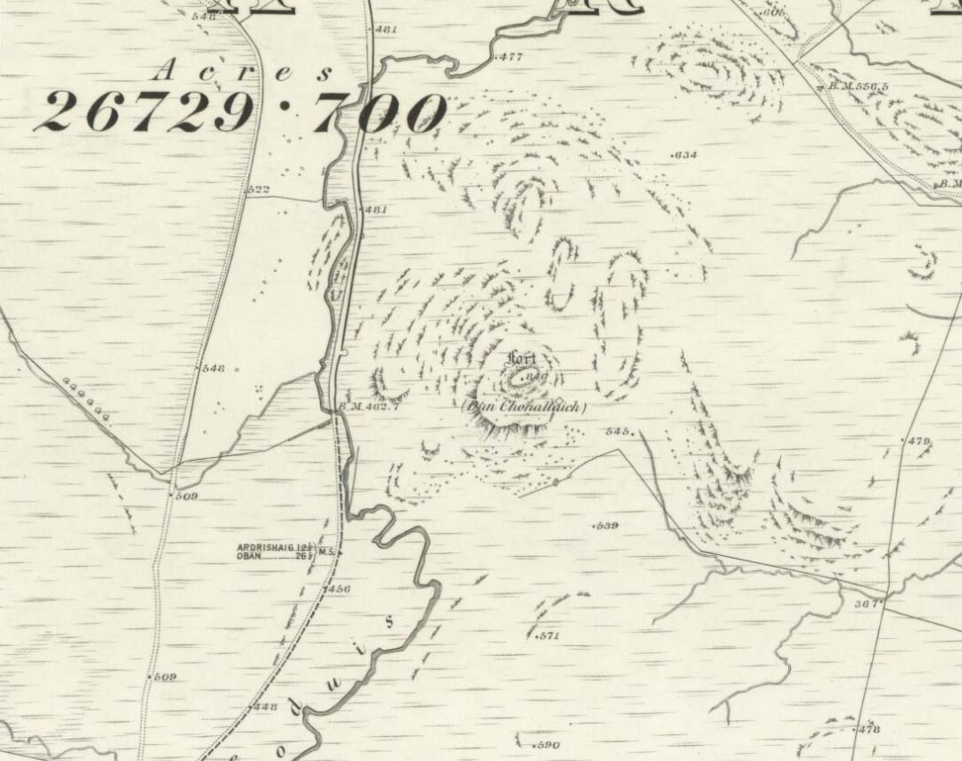
There’s two real ways to get up here: one from the Oban-Kilmartin roadside; the other from Ford village. I’d go for the latter as it avoids the traffic. Walk up the track to Salachary from the village centre, heading west. It’s a gradual uphill climb and after about half-a-mile (past six or seven cup-marked rocks) the great hill rises to your left. Dun Dubh is to your right. Climb over the fence and head for the hilltop.
Archaeology & History
It’s my opinion that this fort, above all others in the region apart from Dunadd, was of paramount importance to our prehistoric ancestors. The reason being that it’s the great pyramidal hill to which the line of tombs in the Kilmartin Valley align, three miles to the south. This prehistoric alignment was quite intentional (if you’ve got your doubts, gerrup there & have a look for y’self — you’ll soon change yer mind).
Curious carved stone found here
The main part of the structure is an irregularly-shaped construction with walling on all sides, measuring about 40 yards by 20 yards. Much of it is pretty well defined – though has been vandalized by various doods in the past: one bunch being a film-crew who used the site in the early 1980s! Inside the main walled fortress are several ruins. The Royal Commission (1988) report told:
“Much of the interior is occupied by a rock spine which is surmounted by a modern cairn, but the NW half is relatively level and it contains, in addition to the modern round-house…and and an S-shaped structure associated with film-making, a number of ruined stone foundations. On the north side there is a rectilinear building, and between the modern round-house and this rectilinear building, there is a further structure…an arc of walling, but its precise shape cannot now be determined without excavation.”
Dun Chonallaich means “the fort of King Connal’s people,” and although much denuded, is well worth the clamber for a short archaeological day out. A curious “gaming-board” was found here (see photo). A portable cup-marked stone in the fort’s southern wall is a modern artifact.
It’s a lovely view from up here too. This is one of many places I’ve sat during a raging thunderstorm. One helluva buzz, believe me!
References:
Gillies, H. Cameron,The Place-Names of Argyll, David Nutt: London 1906.
Royal Commission for Ancient & Historic Monuments, Scotland, Argyll – volume 6, HMSO 1988.
An old stone-lined burial cist could once be seen in this locale: reported in 1953 to have been “discovered in the southwest corner of a field south of Druimyeonbeg farmhouse.” When it was uncovered by the farmer, the covering capstone was missing. Any relics that may have been there were destroyed and there’s now no trace of anything.
References:
Royal Commission on the Ancient & Historical Monuments of Scotland, Argyll – Volume 1: Kintyre, Glasgow 1971.
From the north-end of Loch Tay at Kenmore, follow the road (A827) round down the lochside, through the village of Fearnan and then another 4 miles down. If you park up at the pub at Lawers, walk back up the road for ½-mile, keeping your eyes peeled up the slope on the left where you’ll see the circle visible from the road.
Archaeology & History
Much has been said of this fine old place – also known as Lawer’s Mill – which seems to have been first described by Thomas Pennant in his rambling Tour in Scotland (1772). The local writer William A. Gillies (1938) told that after
“a recent examination of the ground around the circle…suggests that at one time there was an outer circle of stones concentric with the existing one. Most of the stones were removed in order to make more of the field available for cultivation, but there are still large stones buried within a few inches of the surface.”
Folklore
In J. McDiarmid’s Folklore of Breadalbane (1910) he tells of a man from Killin who, on passing by this old circle, heard haunting fairy music. Being inquisitive, he walked up to see what was going on and walked into the circle where the little people were playing. He was obviously lucky and the faerie-folk enjoyed his company, for when he left he was given the gift of a strong, fast, white steed.
Solar folklore may be…?
References:
Gillies, William A., In Famed Breadalbane, Munro Press: Perth 1938.
Take the A816 south from Oban and after 2 miles at the hamlet of Kilmore, turn left. Follow the road for nearly a mile and as the loch appears ahead of you, stop! The small island crannog is close by the bottom of the loch in front of you.
Archaeology & History
Curiously omitted from the Scottish Royal Commission inventory for Lorn (1974), when R. Angus Smith and his friends explored this artificial island in the 1860s and ’70s, he told:
“it is nearly round, not much larger than a good-sized cottage. It is surrounded by stones large enough to be difficult to lift, and in some places showing themselves to have been put together by art. It would appear as if there had been a pretty firm wall all round – very firm it could not be without mortar or heavier stones. Three or four feet within the range of stones is a raised turf-mound, as if this had been the wall of a house; the centre of the space was rather higher than the rest, and there we expected a fire-place to be found.”
Once they’d got onto the old crannog, Smith and his associates started digging, saying,
“by digging about three feet and a half, the ashes of peat were obtained, bones, charcoal and nuts. A very small hole was made, as we had not then received liberty to dig. We were satisfied that this had been a lake-dwelling, and that it had been defended by a wall. Advantage seems to have been taken of a shallow place, and stones must have been carried to it. It may turn out that there is a wooden foundation. It is not easy to see by what means the covering of earth now over the floor was so much raised. The water of the lake forms little or no deposit in summer; art rather than natural circumstances may have raised the soil. The bones here were split, as at the lake-dwelling in the moss.”
References:
Smith, R. Angus, Loch Etive and the Sons of Uisneach, Alexander Gardner: London 1885.
In Thomas Pennant’s A Tour in Scotland and Journey to the Hebrides, 1772 (1790:226), he described there being three prehistoric cairns about four-hundred yards west of Ardminish, or a couple or hundred yards north of the Achamore Standing Stone, on Cnoc na Croise, but they seem to have been destroyed. At least two of them were between 4 and 5 yards across and contained cists. A search for the site by the Royal Commission lads in the 1960s found nothing—although they may have been looking in the wrong place (the grid reference given above is an approximation). Does anyone know anything more about these seemingly lost sites?
References:
Royal Commission for Ancient & Historical Monuments of Scotland, Argyll – volume 1: Kintyre, HMSO 1971.
The Scottish Royal Commission (1971) reported a very large
“standing stone that stood 185m NNW of Achmore House (that) was removed at the beginning of the 19th century. It was reported that is measured 4.9m in height (16ft), 1.2m in breadth and 0.2m in thickness.”
A prehistoric cairn seemed to have accompanied this monolith—as reported by Thomas Pennant in 1772—but it too has been destroyed. Pennant told us how the monolith was,
“a great rude column, sixteen feet high, four broad and eight inches thick.”
Not bad at all! It was still extant, although leaning to the southwest in the year 1790 (OSA 1791-9); appearing to have been removed about 1800. No trace of it remained when the Ordnance Survey lads looked here in 1869.
References:
Royal Commission for Ancient & Historical Monuments of Scotland, Argyll – volume 1: Kintyre, HMSO 1971.
Stone Circle (destroyed): OS grid-reference – SD 821 613
Also known as:
Druid’s Hill Circle
Druid’s Circle
Archaeology & History
Speight’s 1895 map – showing position of circle
Not included in any previous archaeological surveys of megalithic rings, this circle of stones was apparently visible from quite a distance away, sitting on the hillside where now there is woodland. It was described by the great Yorkshire historian Harry Speight (1892, 1895), though today it seems that all remains of it have vanished.
An early description of it came after an excursion to the site by local antiquarians, who told that “at Cleatop, about a mile to the south of Settle, are the remains of an ancient stone circle.” (Horsfall-Turner 1888) A few years later, Mr Speight gave us more details of the place, saying:
“A little above Cleatop Farm (near Rathmell)…is Cleatop Wood. Cleatop derives its name from the A.S. cleof, a rocky aclivity; Latin clivus, a bank or slope. Near the northeast side of the wood there was once a very noticeable Druid’s Circle, about 60 feet in diameter; indeed, Mr Thomas Brayshaw of Settle, informs me that within the memory of persons still living, it was so regular and well-defined that one or two gaps caused by the removal of stones could be easily distinguished. The eminence at the rear of the site has, from time immemorial, been known as Druid’s Hill.”
Some years later, that very same local historian Tom Brayshaw (1932) wrote:
“The Ordnance map marks, on the steep slope to the north of Cleatop Wood, ‘site of Stone Circle’. It needs a very keen eye to identify the few stumps that remain today, and it is deplorable that this most interesting monument, after enduring for so many centuries, has been destroyed during the last eighty years. In 1847 a description of the circle, as it then was, was sent to Captain Yolland of the Ordnance Survey.
“”I suppose the circle of stones in Cleatop High Park to be aboriginal British or Druidical remains from the following appearances: the circle is complete and the large stones are set on end, some of them several tons weight. The stones are twelve in number now standing, beside several others that seem to be rolled a short distance, as it is placed on the ascent of a steep hill and commands a beautiful and extensive prospect (more so than any given point of the same altitude in the vicinity). The circle is 36 feet in diameter.”
“A few stones were still standing in 1883. The hill above long bore the name Druids Hill. The Enclosure Acts passed towards the end of the 18th century greatly increased the number of drystone walls in the parish, and it is probable that many old stone monuments were destroyed in making them and in their subsequent repair”.
We have no references of burials or other excavations here to give us any idea of whether human remains had ever been found. It’s an intriguing place in the landscape though…and worthy of further explorations…
References:
Brayshaw, Thomas, A History of the Ancient Parish of Giggleswick, Halton & Co.: London 1932.
Horsfall-Turner, J. (ed.), ‘Antiquarian Excursion to Giggleswick and Settle,’ in Yorkshire Folklore Journal, vol.1, T. Harrison: Bingley 1888.
Speight, Harry, The Craven and Northwest Yorkshire Highlands, Elliott Stock: London 1892.
Speight, Harry, Tramps and Drives in the Craven Highlands, Elliot Stock: London 1895.


")
")