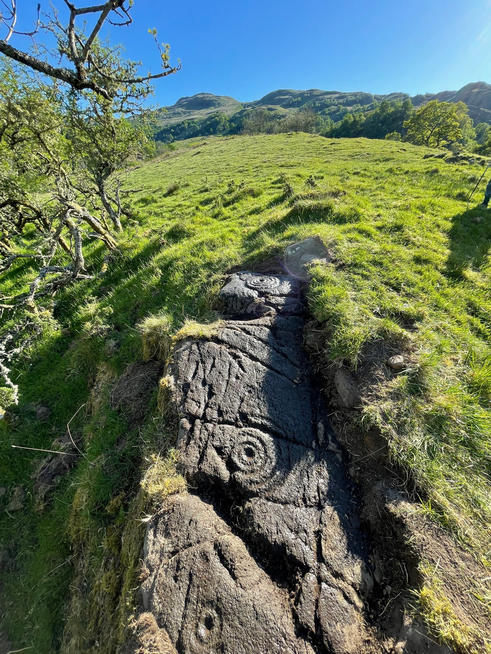
Take the same directions as if you’re visiting the Tormain (1) carving (the best one of the bunch here), but about five yards before reaching it, to your immediate left, just at the edge of where the hill drops down slightly, you’ll see a small flat rock poking out of the ground that may have been cut and quarried at some time in the past. That’s the one!
Archaeology & History
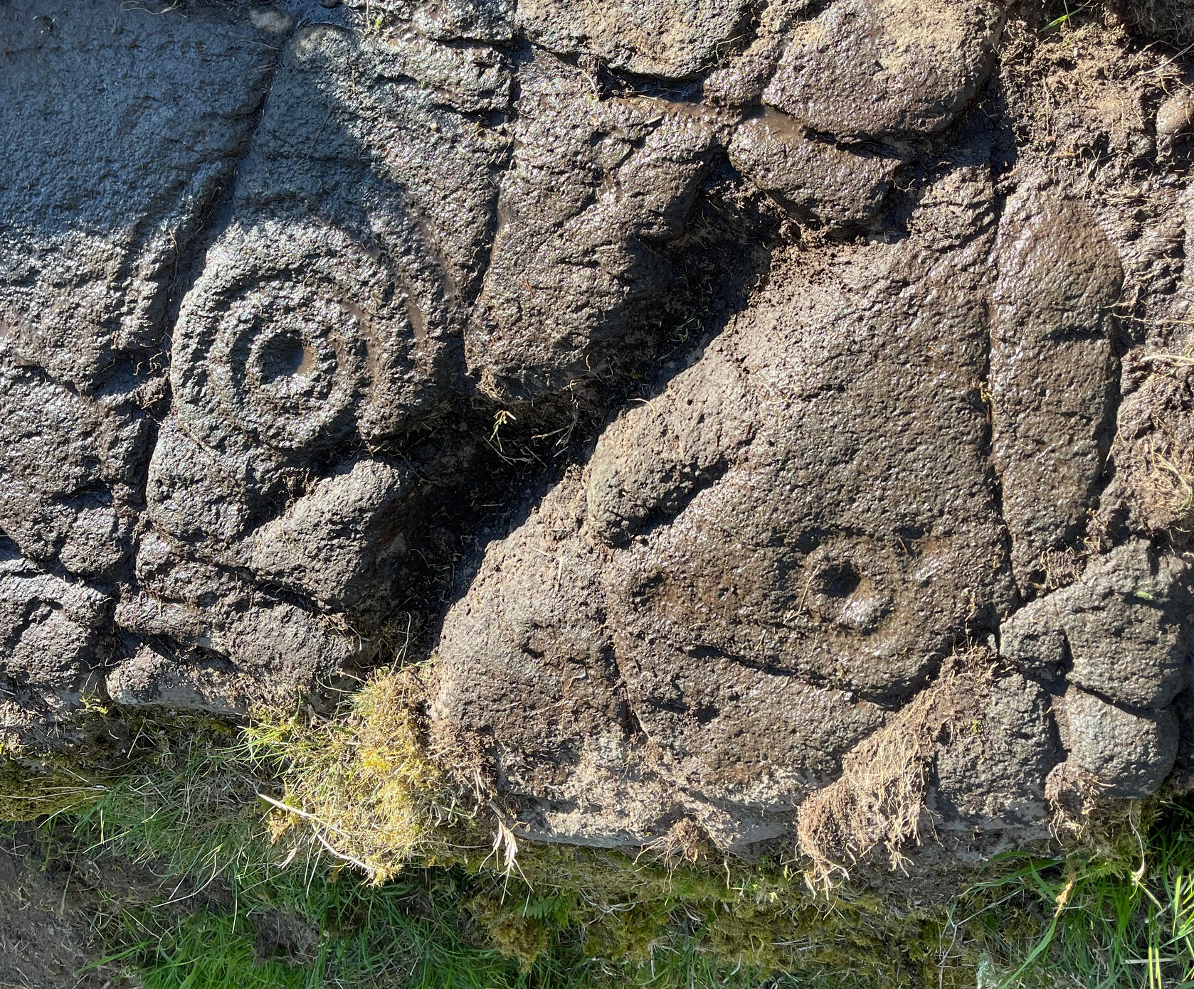
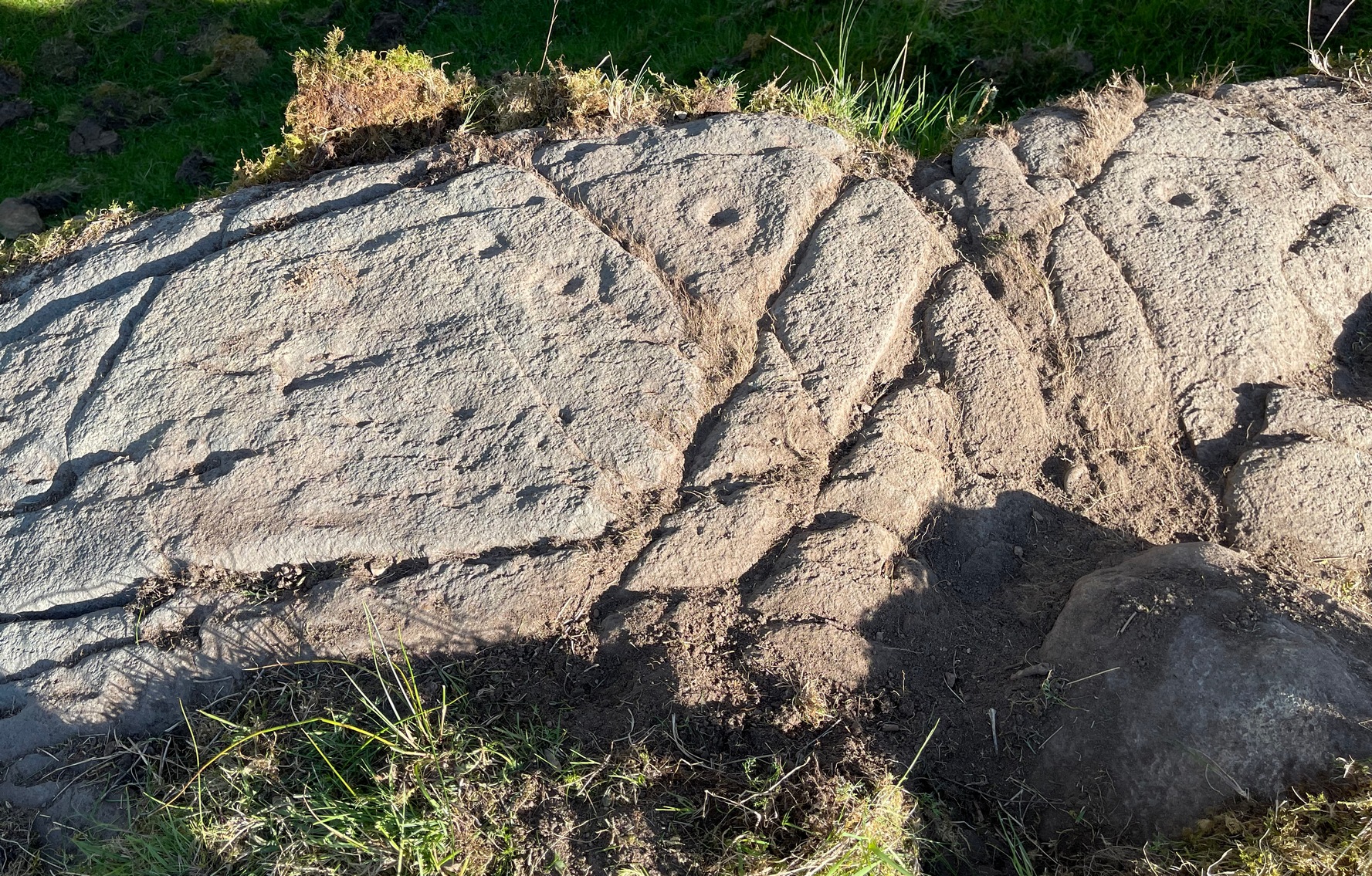
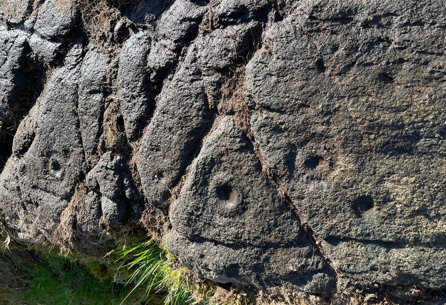
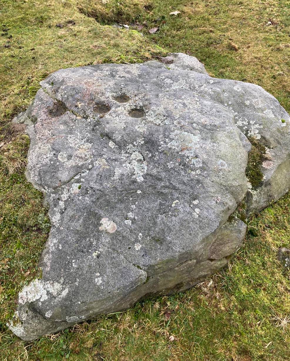
This small compact design looks like a typical cup-marked stone with the usual scatter of cups in no seeming order—until, that is, you walk around it and look at it from different angles, whereupon you’ll notice that a couple of distinct deep carved lines have been cut in a cross formation, with cup-marks at the ends of the crucifix. My view of this is that cup-marks were done first, probably in the standard Bronze Age period, and the ‘cross’ was cut into the stone at a much later date, probably during the early christian era. The depth of the lines which create the ‘cross’ is deep and thin at the bottom, suggesting a metal tool, which seems to have been cut into an natural crack. Visitors here will notice a small drill-hole near the edge of the stone which seems to have been done by local quarrymen, probably in the 19th century.
It was first described in Romilly Allen’s (1882) article on the Tormain stones. He called it ‘Stone E’ and told that it
Location of Tormain 5Cups, lines & cross form
“is situated about half-way between stones A and D, and is furthest to the east. It measures 1 foot 4 inches by 1 foot 9 inches, and projects 1 foot above the turf. Its upper surface is flat, and on it are carved eight cups varying in diameter from 1 to 2½ inches. There are two connecting grooves between three of the cups, forming a rude cross. Another cup has a channel leading over the edge of the stone.”
In November 1927, the Royal Commission dudes visited the carving (and its companions), but they had to roll back the turf to see it clearly. On the stone they saw that “at least nine or ten cup-markings, in some cases with connecting gutters, are still more or less clearly outlined.”
Carving highlighted (Morris ’82)Ron Morris’s old photo
When Ron Morris (1981) visited here, he highlighted the carving in chalk to get a decent impression of the design, as the attached photo here shows. Many traditional cultures ritually paint their carvings at set times of the year, in traditions that go back many centuries—perhaps even millenia. In all probability the same thing was done at some of the British petroglyphs, although there are no remaining traditions. Anyhow, Morris described it succinctly as:
“½m square, ¼m high…on which are: eight cups up to 7cm (3 in) diameter and 4cm (1½ in) deep and some grooves, to of which connect some of the cups to form a well-defined Cross.”
The stone was looked at by the great rock art explorer Kaledon Naddair of Edinburgh, but sadly I’m unable to locate his report and the fine illustrations that always tended to accompany them. If you’re reading this sir, give us your valuable input!
Beckensall, Stan, Rock Carvings of Northern Britain, Shire: Princess Risborough 1986.
Beckensall, Stan, British Prehistoric Rock Art, Tempus: Stroud 1999.
Feachem, Richard, Guide to Prehistoric Scotland, Batsford 1977.
Hadingham Evan, Ancient Carvings in Britain: A Mystery, Garnstone: London 1974.
Morris, Ronald W.B., “The Cup-and-Ring and Similar Early Sculptures of Scotland; Part 2 – The Rest of Scotland except Kintyre,” in Transactions of the Ancient Monuments Society, volume 16, 1969.
Morris, Ronald W.B., The Prehistoric Rock Art of Southern Scotland, BAR: Oxford 1981.
Royal Commission Ancient & Historical Monuments of Scotland, Inventory of Monuments and Constructions in the Counties of Midlothian and West Lothian, HMSO: Edinburgh 1929.
Acknowledgements: Huge thanks to Jan Carrington for use of her photos. 🙂
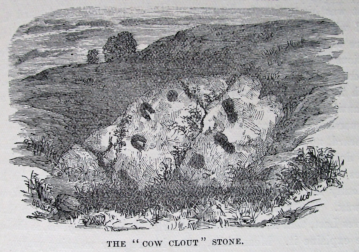
OK—I’m cheating here, as I’ve not visited this site (bad of me!). The directions given here are from Harper’s 1876 Rambles in this area. He told that the stone “stands about 100 yards to the north of the march dyke betwixt Upper Ervie, now Ken-Ervie and Nether Ervie. There is little to indicate its whereabouts, but the visitor coming from Kenmure Bridge, and leaving the road on the left, opposite Ringour and Bennan farms, on the opposite side of Loch Ken, would come upon it without much trouble by following the march dyke half a mile up.” Basically, along the A713 just over 2 miles north of the bridge at Parton (½ mile before reaching the Galloway Activity Centre), 60 yards from the “Farm Access No Parking” spot, in the trees a long straight line of walling runs uphill. That’d be my route—straight up!
Archaeology & History
This is a curious entry that I’ve added without visiting the site; but as I might never get to see it I thought it should be displayed in the hope that others might check it out. The earliest literary reference to it is from Crosbie’s (1845) entry in the New Statistical Account, where he implies that the markings on the stone are not of Nature’s handiwork. In Malcolm Harper’s (1876) fine work exploring the history and folklore of this region, he gave us the first illustration of the stone, which looks suspiciously like elements that we find on cup-and-ring stones. Many years later when the Royal Commission (1914) lads followed up on Crosbie’s entry, they thought the markings were probably Nature’s handiwork. They told that:
“It is an irregular mass of outcropping rock about 3 feet in diameter, and bears on its surface certain depressed markings supposed to represent a cow’s foot, a horse-shoe, and impressions which might be made by a man’s foot and knee in the act of kneeling. The markings appear to be natural.”
But it’s the animistic elements and traditions here which are important and which gave the stone its very name…
Folklore
When Rev. W.G. Crosbie (1845) first wrote about this stone, he was narrating the tale told of it by local people, whose traditions were greatly neglected by the majority of writers at that time. Such stories should be preserved at all times, as they tell us more about the psychocosms of pre-industrial cultures. Here,
“On the farm of Arvie, there is a flat stone about three feet in diameter, on which are the marks of what might be supposed a cow’s foot, a horse shoe, the four nails on each side being very distinct, and the impression which might be made by a man’s foot and knee while he was in the act of kneeling, the knot of the garter being quite evident. The tradition connected with this remarkable stone, commonly called the ‘Cow Clout,’ is, that the proprietor, in order to get up arrears of rent, “drave the pun,” or in other words, carried off the hypothecated stock, while a fierce resistance was made by the people, and that over this stone, on which a man had just been praying for relief against his enemies, the cattle passed followed by an officer on horseback, and that it remains as a memorial to posterity of the cruel deed.”
If someone in that neck o’ the woods can find out if the stone’s still there and perhaps send us a photo, or stick it on our Facebook group, that’d be great! 🙂
References:
Coles, Fred, “The Recent Cup and Ring Mark Discoveries in Kirkcudbrightshire”, in Proceedings Dumfriesshire & Galloway Natural History and Antiquarian Society, volume 5, 1888.
Crosbie, W.G., “Parish of Parton,” in New Statistical Account of Scotland – volume 4, William Blackwood: Edinburgh 1845.
Harper, Malcolm M., Rambles in Galloway, Edmonston & Douglas: Edinburgh 1876.
Royal Commission Ancient & Historical Monuments & Constructions of Scotland, Inventory of Monuments and Constructions in Galloway – volume 2: County of the Stewatry of Kirkcudbrightshire , HMSO: Edinburgh 1914.
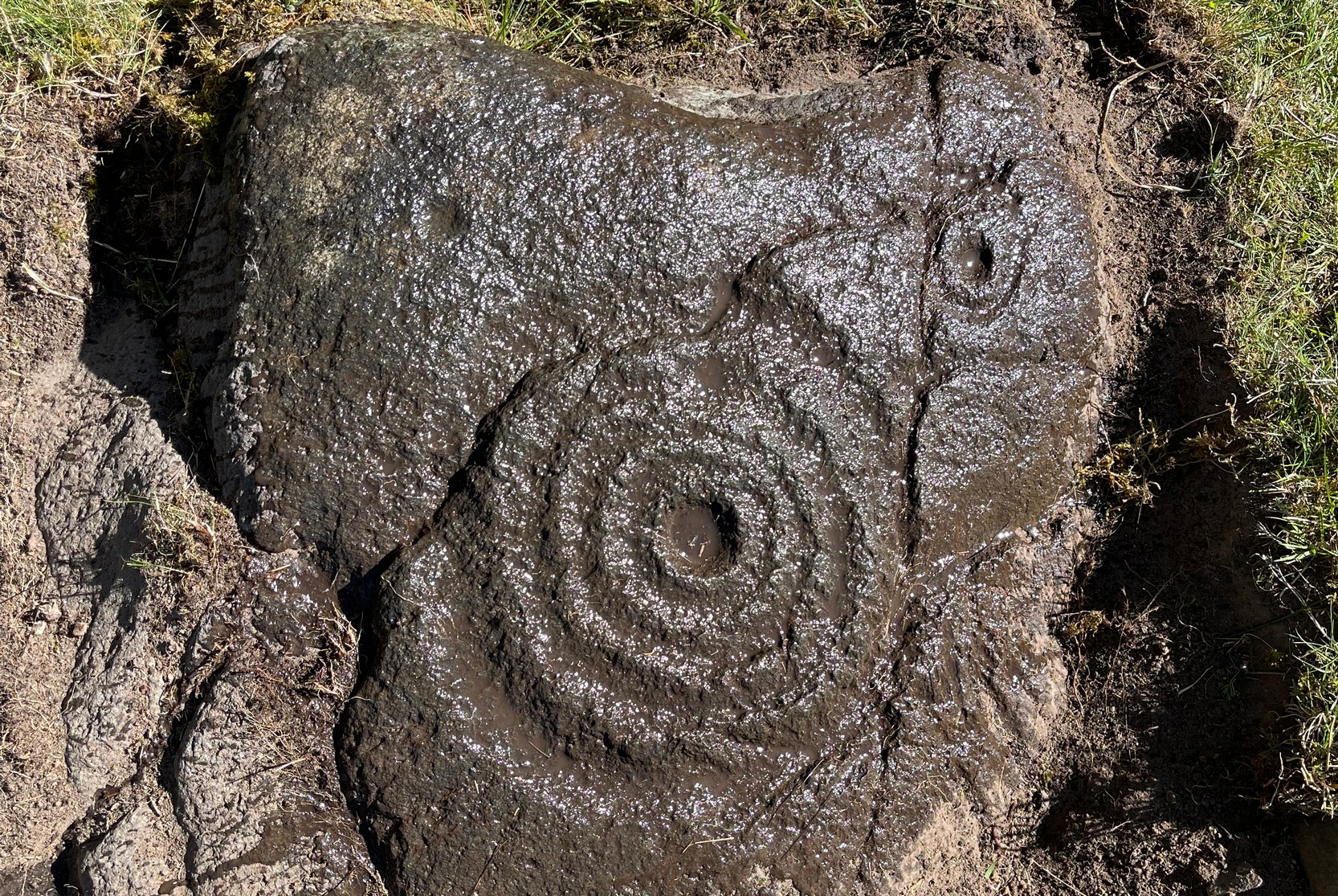
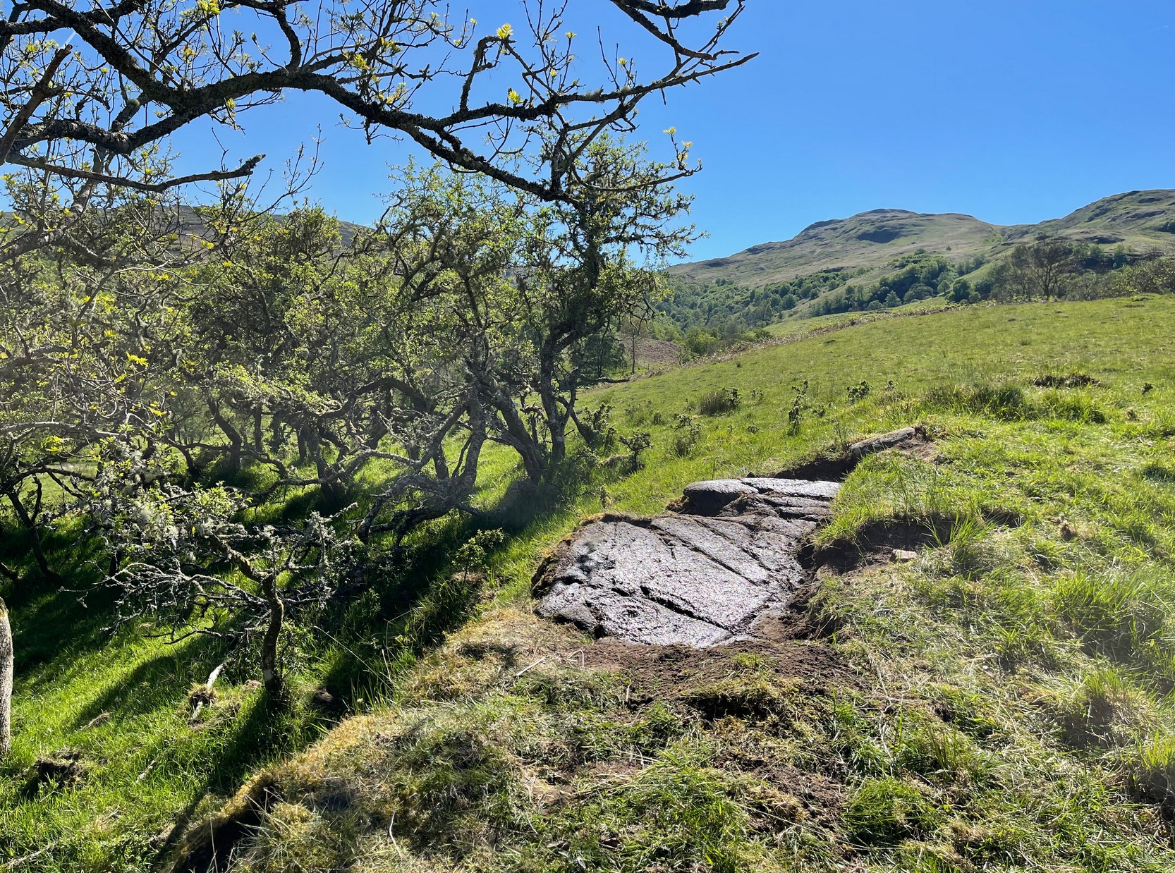
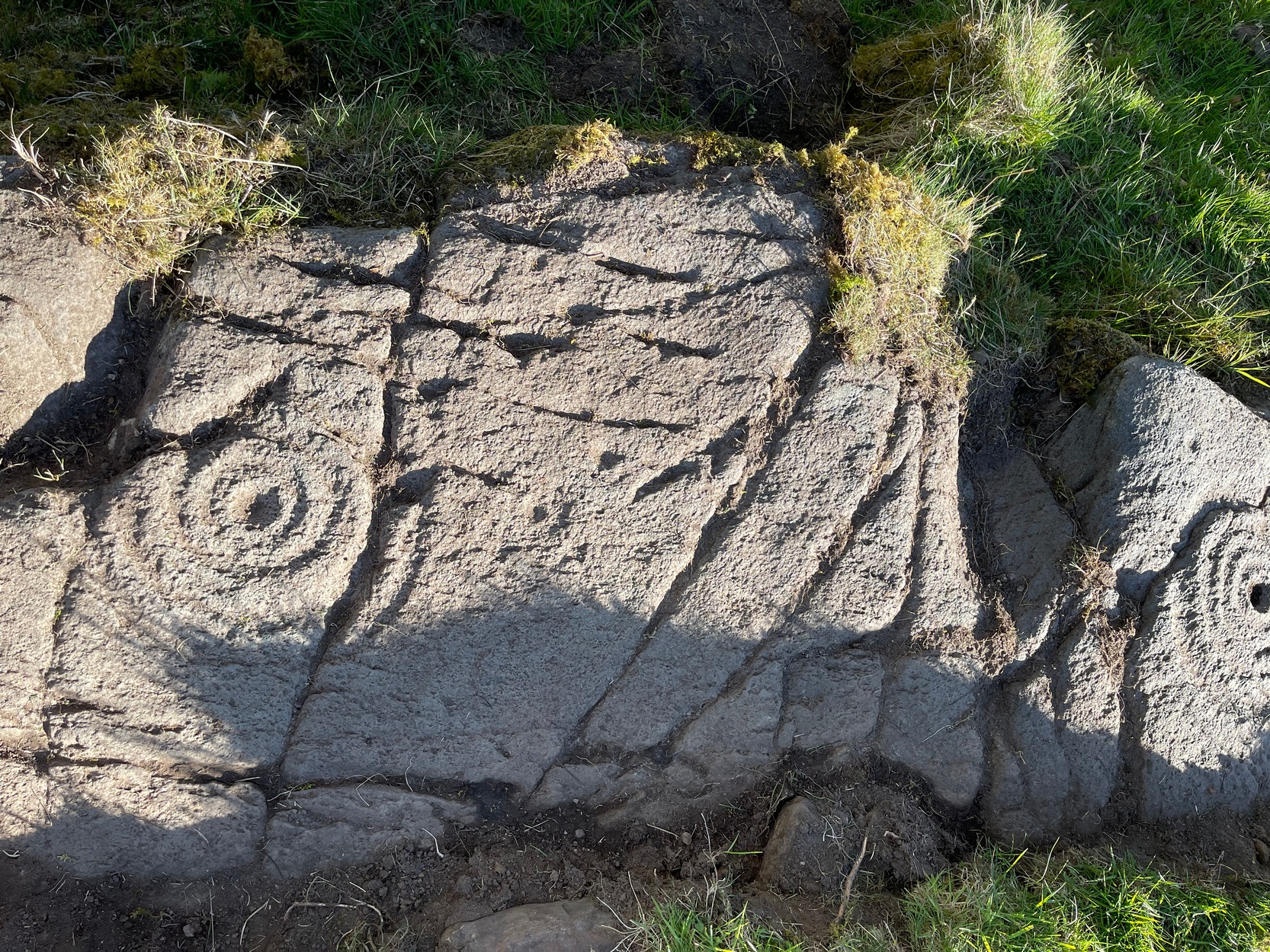
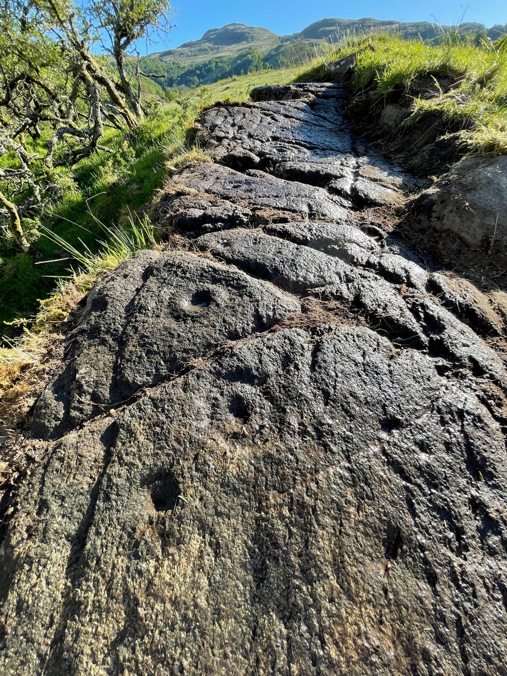
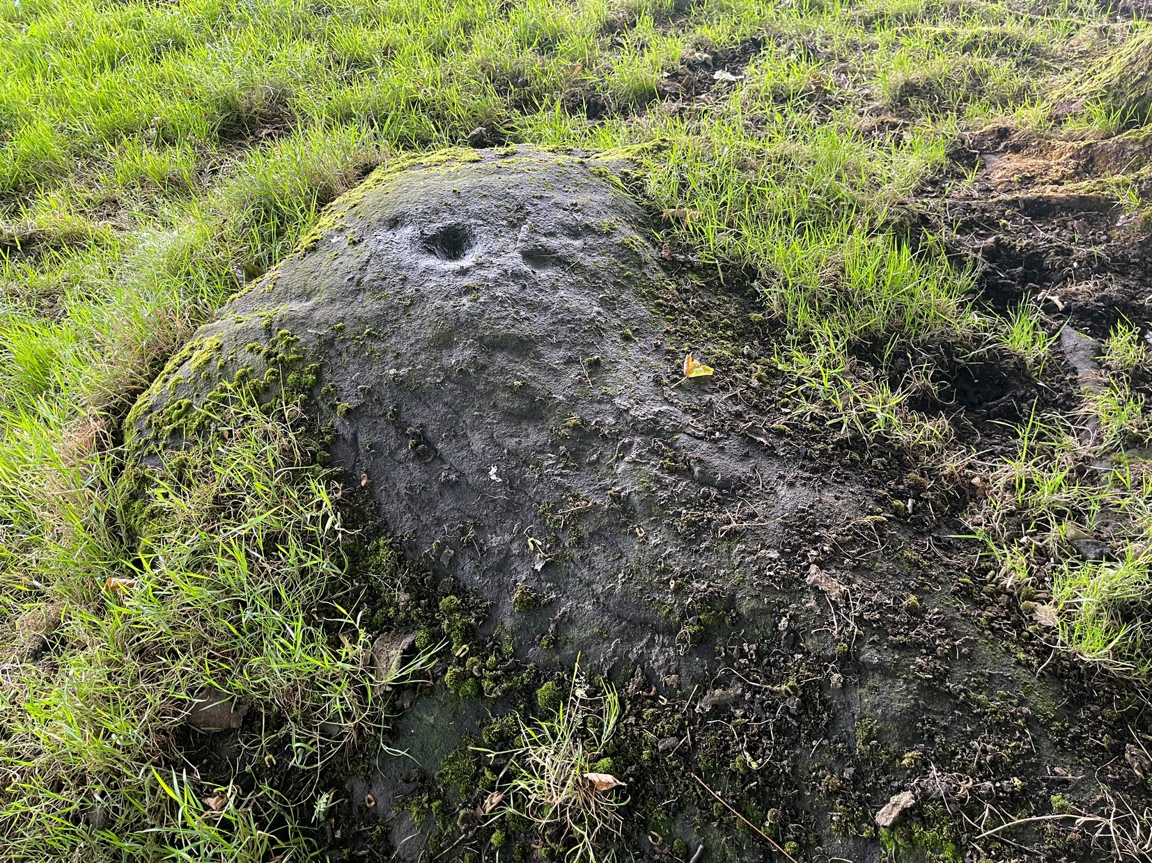
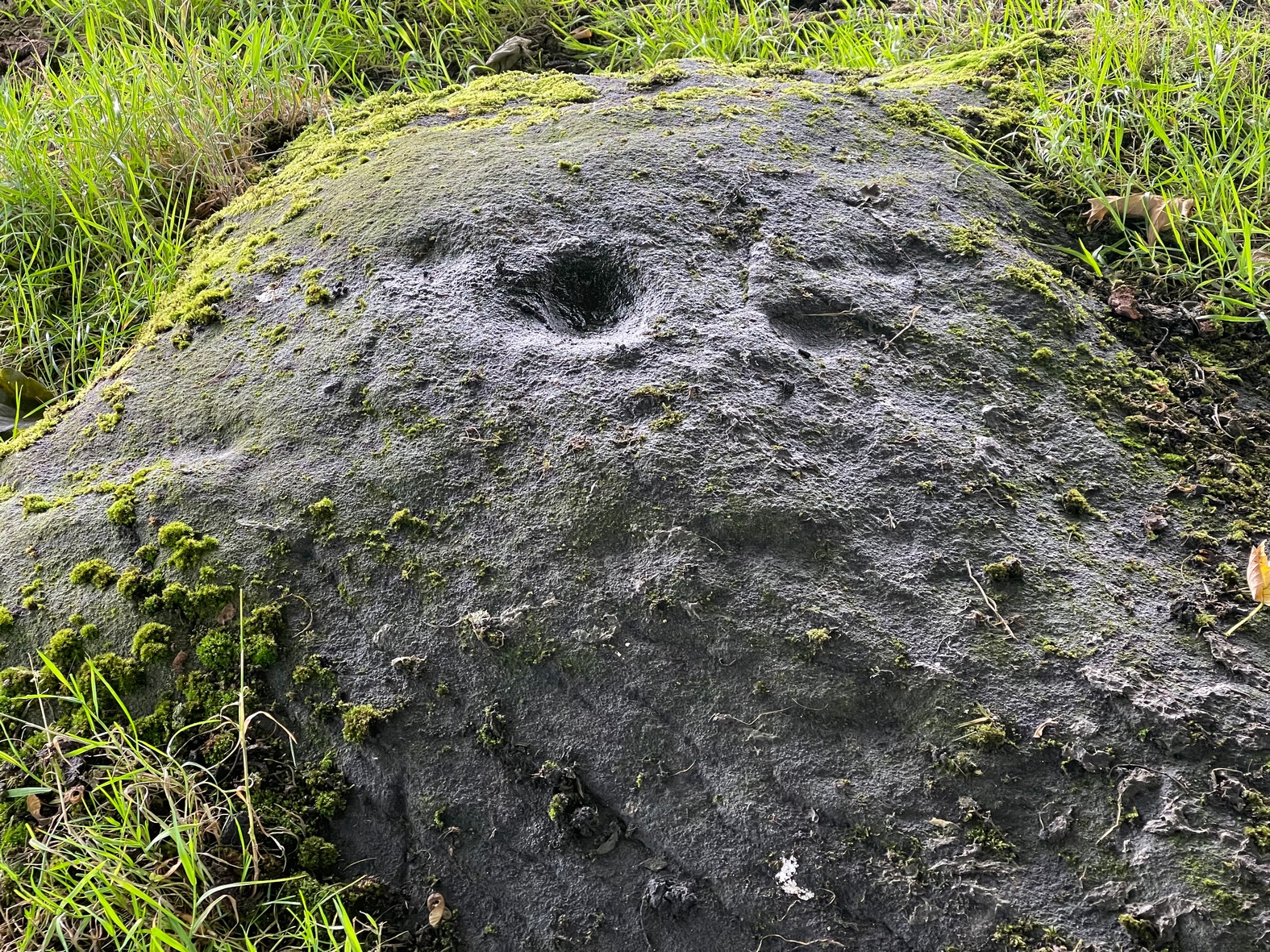
This is a relatively new find that was uncovered in 2019 by members of the Association of Certified Field Archaeologists, on the western edge of a small bowl of blackthorn trees, just past one of the Corrycharmaig East carvings — and it’s a bit of a beauty!
Topmost part of carvingCorrycharmaig (9) stone
Described, albeit briefly, in the superb survey by Gardiner, King & MacInnes (2024), the carving here has been cut into a sloping straight line of rock along the ridge of a very tiny cliff and consists of cups, single rings and multiple rings. At its crown, so to speak, where the rock surface levels out and is flat, a very well-preserved multiple cup-and-ring greets our senses: a cup-and-four rings to be precise. The outermost edge of the rings cuts into a natural crack that runs to the edge of the stone; and close to where this crack reaches the edge, another standard cup-and-ring rests against it. On this same section you’ll see a single cup which, by the look of it, was intended to have a much wider ring surrounding it—but for some reason it was never executed.
Second multiple-ringerSecond multiple-ring
From the topmost section, the rock then slopes gradually downward and the design is broken by several natural splits in the stone before we reach a single unfinished cup-and-ring and a solitary cup-mark. These occur shortly before we reach a near-duplicate of the multiple-ringer that we’ve just seen on the flat top of the stone. The outer ring of this is broken and the edges of it are intruded (again) by natural cracks in the stone (a not uncommon feature). The erosion level of this and its fellow four-ringed compatriot at the top are much the same, suggesting that the two were executed at around the same time.
Lower-half with cup&ringsClose-up of cup&rings
As we move down the slope of the rock with its veritable scattering of geological splits, the rest of the design consists of several single cup-and-rings—at least three of them—over its lower-half, almost in a gentle arc over the surface. The one closest to the four-rings has a single cup-mark attached to its outer edge and another single one just a few inches away from it. The others don’t seem to have any additional carved features attached to them; although one or two other singular cup-marks can be seen on this, the lowest section of the carving.
Looking to the hillsFrom the bottom up
An interesting feature noted here is the direction that this line of rock points to: a dip between two distinct rocky peaks on the horizon and which is close to the winter solstice sunset. I should point out however, that the relationship between open air petroglyphs and astronomical alignments (in Britain at least) is very debatable. Even alignments from one carving to another are pretty meaningless, despite the attempts of some modern archaeologist to show otherwise. In my younger days when I raced into rock art studies, I threw everything I had to show astronomical and other alignments were involved in these carvings—but it turned out not to be…. Instead, it turns out that some of these seeming ‘alignments’ (and only a few) relate to pathways and ancient routes: pointers, if you like, to the way ahead. Makes sense…
References:
Gardiner, M., King, L. & MacInnes, Dugald, In the Glen of the Dark Goddess, Bell & Bain: Glasgow 2024.
Acknowledgements:Huge thanks for use of the Ordnance Survey map in this site profile, reproduced with the kind permission of the National Library of Scotland.
From Steeton village, go up Mill Lane, turning right and then bending up the steep Barrows Lane for a half-mile or so, where in turns into Redcar Lane. There’s a row of old cottages on your left with a green lane track running into the fields at the back of them. Four fields along you’ll reach a long straight line of walling running uphill. Up here, above and past the long geological stretch of quarried rocks, the land levels out and two trees sit next to each other by walling. The carving’s beneath them.
Archaeology & History
Close-up of carving
Rediscovered in the summer of 2024 by Thomas Cleland, a deeply worn cup-mark is the primary feature of this petroglyph on the topmost section of the stone, with the remains of a faint incomplete ring around one side of it. Three or four other smaller cup-marks can be seen close to the main one. There may be another cup-marked stone on an adjacent rock, with a lines running away from it, but we need to see that in better light or have one of the computer-tech doods to give it their attention to know for sure.
This is an outstanding site visible for miles around in just about every direction – so getting here is easy! If you’re coming from Harrogate, south down the A658, turn right and go thru North Rigton. Ask a local. If you’re coming north up the A658 from the Leeds or Bradford area, do exactly the same! (either way, you’ll see the crags rising up from some distance away) As you walk to the main crags, instead of going to the huge central mass, you need to follow the line of walling down (south) to the extended cluster of much lower sloping rocks. Look around and you’ll find it!
Archaeology & History
On the evening of May 27, 2024, I received a phone call from a Mr James Elkington of Otley. He was up Almscliffe Crags and the wind was howling away in the background, taking his words away half the time, breaking the sentences into piecemeal fragments. But through it all came a simple clarity: as the sun was setting and the low light cut across the rocky surface, a previously unrecorded cup-and-ring design emerged from the stone and was brought to the attention of he and his compatriot Mackenzie Erichs. All previous explorations for rock art here over the last 150 years had proved fruitless—until now!
Looking northwestCentral cup-&-ring
On the east-facing slope of the stone, just below the curvaceous wind-and-rain hewn shapes at the very top of the boulder, is a singular archetypal cup-and-ring. It’s faint, as the photos show, but it’s definitely there. What might be another cup-and-ring is visible slightly higher up the sloping face, but the site needs looking at again when lighting conditions are just right! (you can just about make it out in one of the photos) But, at long last, this giant legend-infested mass of Almscliffe has its prehistoric animistic fingerprint, bearing fruit and giving watch to the countless heathen activities going back centuries. Rombald’s wife Herself might have been the mythic artist of this very carving! (if you want to read about the many legends attached to the major Almscliffe rock outcrop, check out the main entry for Almscliffe Crags)
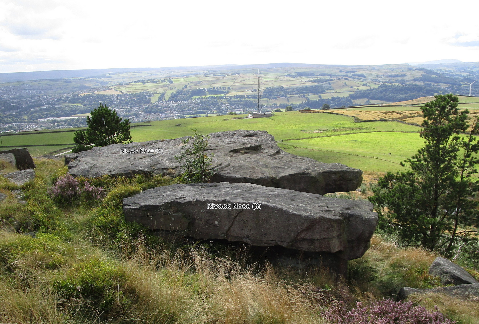
Follow the directions as if you’re visiting the fascinating Wondjina Stone and its companion. From here look at the large rocks on the edge of the drop a few yards away (west) and you’re looking for the flattest rectangular rock jutting out over the edge of the slope, about 15 yards from the walling. The carvings of Rivock (2) and (3) are on the adjacent rocks.
Archaeology & History
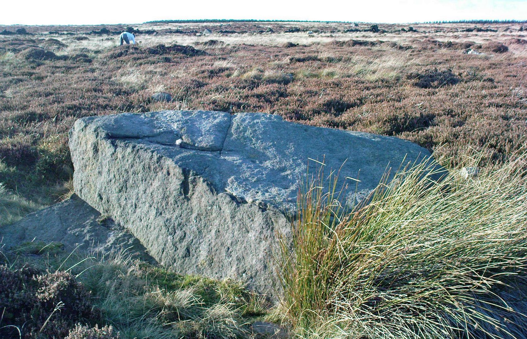
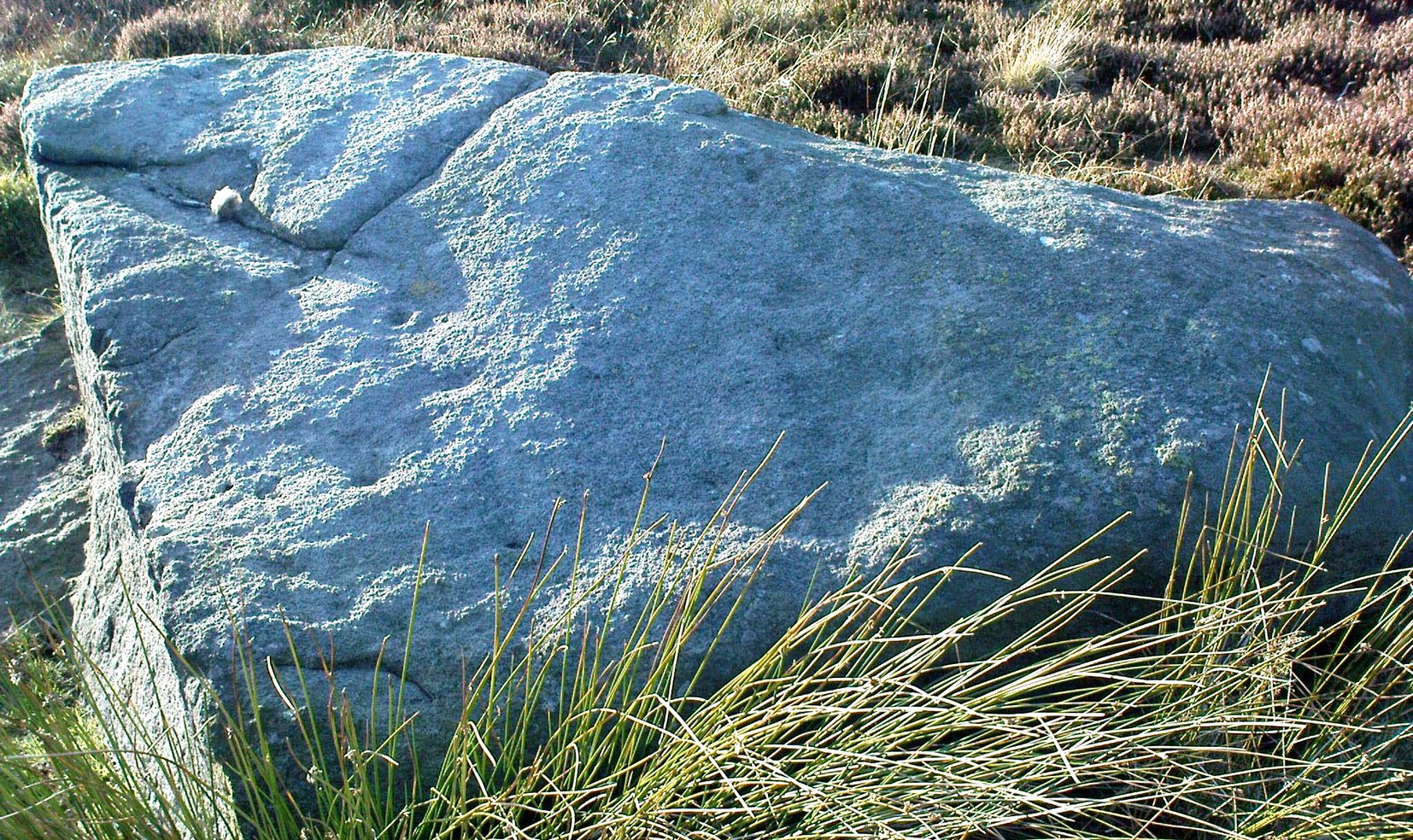
The southernmost of (at least) three cup-marked rocks on the edge of this outcrop, it isn’t a carving I’d necessarily include in my own surveys nowadays. It’s a dubious one to say the least. Nonetheless, earlier surveyors added it in their catalogues.
Lichen-covered “cups”
First mentioned in John Hedges’ (1986) survey, this large and roughly flat rectangular boulder possesses three or four questionable cups close to the edge of the stone. Boughey & Vickerman (2003) subsequently included it in their own work—copying Hedges’ notes—and told it to be a “large rock. About three cups on NW side.” Have a look at it when you visit the other more impressive Rivock carvings nearby and see what you think…
References:
Boughey, Keith & Vickerman, E.A., Prehistoric Rock Art of the West Riding, WYAS 2003.
Hedges, John (ed.), The Carved Rocks on Rombald’s Moor, WYMCC: Wakefield 1986.
Morris, Ronald W.B., “The Prehistoric Rock Art of Great Britain: A Survey of All Sites Bearing Motifs more Complex than Simple Cup-marks,” in Proceedings of the Prehistoric Society, volume 55, 1989.
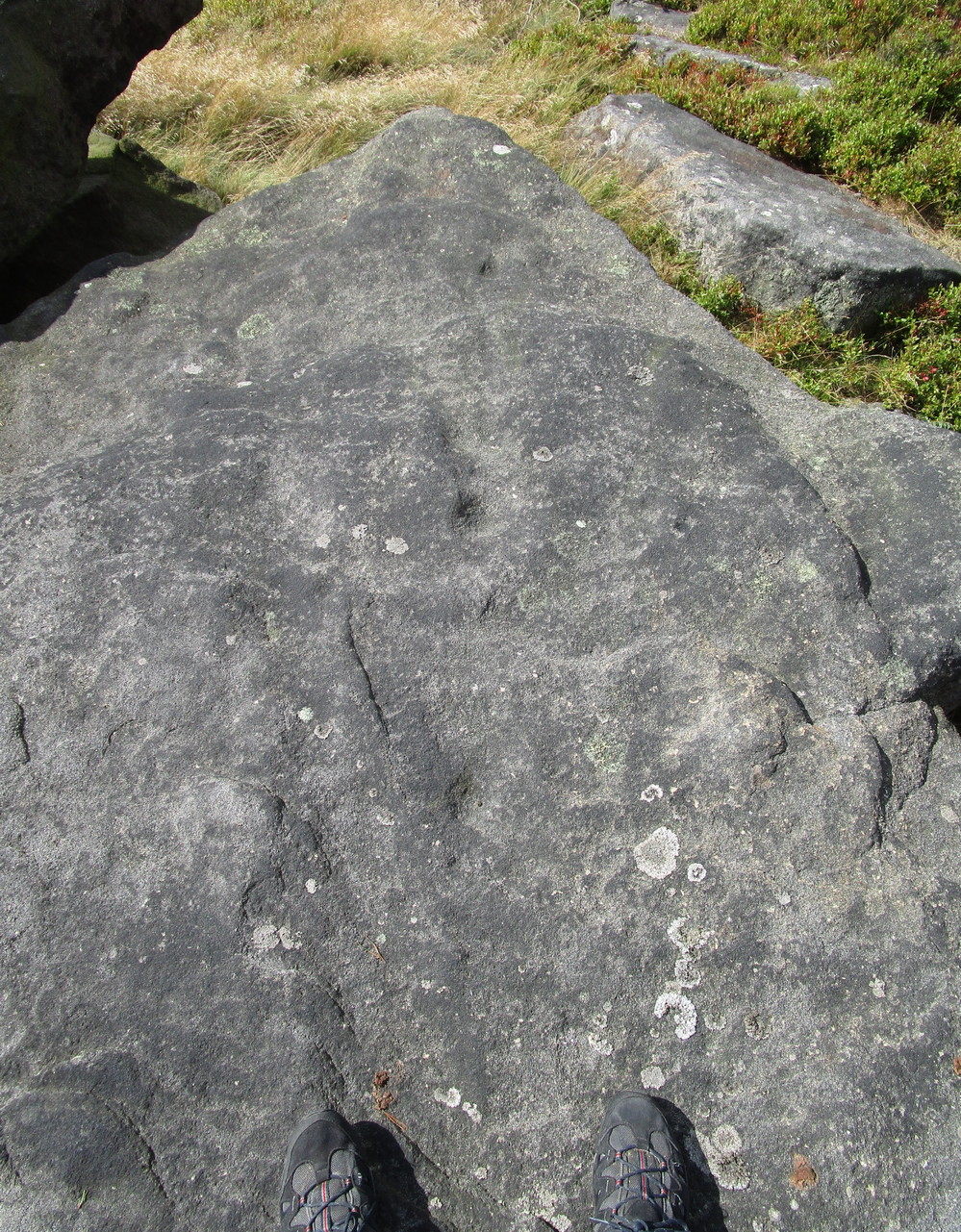
Take the same directions as if you’re visiting the fascinating Wondjina Stone and its companion. From here, just a few yards to the west, are the large rocks overhanging the steep hill, several of which have cup-markings on them (including the carvings Rivock Nose [1] and [2]). This particular carving is the one closest to the wall. You can’t really miss it!
Archaeology & History
Line of 3 cups
A simplistic design that’ll only be of interest to the real geeks amongst you; but you might as well give it your attention when you’re looking at the adjacent Wondjina Stone. On its large surface, the most notable ingredients are the three large cups that run (roughly) in a straight line from the middle of the stone to its outer pointy edge. You can see them pretty clearly in the photo. Several other cup-marks can be seen on the more northwesterly side of the stone.
It was first described in John Hedges (1986) survey, whose notes were simply copied in the subsequent survey of Boughey & Vickerman (2003) where, in their traditional way, gave a very basic description, saying, “Large gritstone outcrop: 3m x 2m. Five cups towards NW edge.”
References:
Boughey, Keith & Vickerman, E.A., Prehistoric Rock Art of the West Riding, WYAS 2003.
Hedges, John (ed.), The Carved Rocks on Rombald’s Moor, WYMCC: Wakefield 1986.
Morris, Ronald W.B., “The Prehistoric Rock Art of Great Britain: A Survey of All Sites Bearing Motifs more Complex than Simple Cup-marks,” in Proceedings of the Prehistoric Society, volume 55, 1989.
From East Morton, head up the winding Street Lane for just over a mile until, on your right-hand side, you hit the long straight Roman Road, or Ilkley Road as it’s known. Literally 690 yards (0.63km) up, on your left a footpath is signposted. Take the path alongside the wall, through the first gate (note the pile of stones at this gate, which are the remains of the destroyed Bradup stone circle) then keeping on for ⅓-mile till you reach another gate, then 200 yards to the next one where you reach the moorland proper. From here you need to walk through the heather, just over 300 yards southwest where you’ll reach this large rock. Y’ can’t miss it!
Archaeology & History
Looking down at the CnR
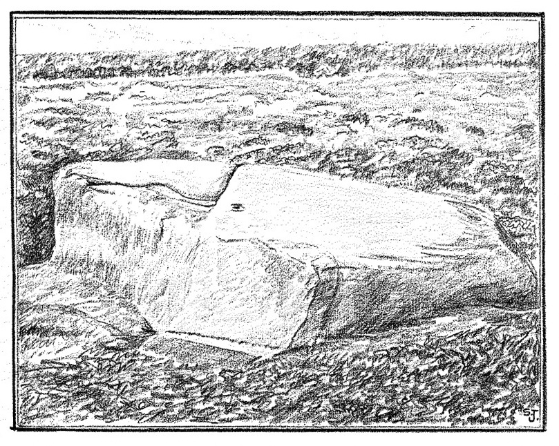
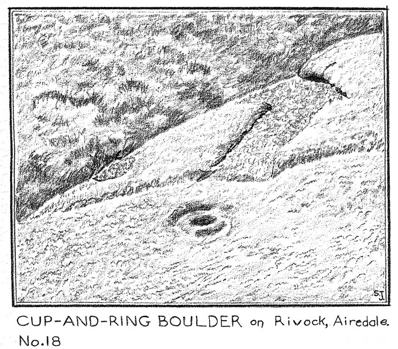
Considering the size of this stone, visitors might expect there to be more on it than there actually is; although a large section of it has been quarried off and there might have been more to it in earlier times. A basic cup-and-ring with one or two single cup-marks elsewhere on its surface, the carving was first described by Stuart Feather (1964) following one of his many rambles hereby, when he was checking out the Rivock carvings a short distance to the west (calling it the Rivock 18 stone). He wrote:
S. Feather’s 1964 sketch
“On the eastern edge of the Rivock plateau, about half-a-mile west of the stone circle at Bradup Bridge, is a cup-and-ring marked rock of a pronounced triangular shape. This at present measures 10ft by 8ft and is 3ft high at its western side… At some time in the past it has been quarried, probably to build part of the adjacent gritstone walls. The 8ft side of the rock has quite distinct drill marks visible…
Close-up of the CnR
The rock has…on its sloping surface a very fine cup-and-ring mark, the ring 6in in diameter around a cup 2in deep, all finely executed and well preserved. Running south from this cup-and-ring mark is a level area 3ft long and 5in wide, which ends alongside the ring at one end and at the quarried edge of the rock at the other. This is probably the former position of a fossil which has weathered out and its alignment onto the cup-and-ring may be due to the carving having been deliberately sited in juxtaposition to this very distinct natural feature. Only one other 2in deep cup remains on the surviving original portion of the rock; others may have been quarried away.”
References:
Boughey, Keith & Vickerman, E.A., Prehistoric Rock Art of the West Riding, WYAS: Wakefield 2003.
Feather, Stuart, “Mid-Wharfedale Cup-and-Ring Markings – no.18, Rivock”, in Bradford Cartwright Hall Archaeology Bulletin, 9:2, 1964.
Hedges, John (ed.), The Carved Rocks on Rombalds Moor, WYMCC: Wakefield 1986.
Cup-Marked Stones (lost): OS Grid Reference – SE 9657 8840
Archaeology & History
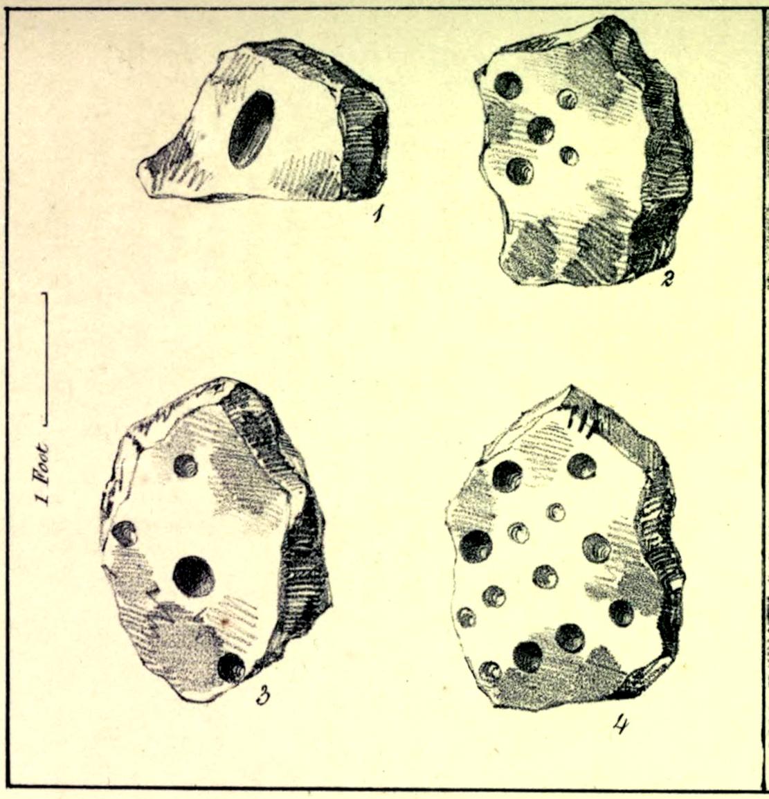
In the autumn of 1848, antiquarian John Tissiman (1850) and his associates took to uncovering two burial mounds amidst a large cluster of them on the eastern edge of West Ayton Moor. This one at Way Hagg was quite a big fella, measuring 36 yards across. When they cut into its northern edge towards the centre, 8-10 feet in, they came across an upright stone, nearly two feet high, on which five cup-marks had been cut. (see sketch, no.2) Slightly beyond this were three other stones (in sketch, nos.1, 3 & 4), each with cup-marks on them, beneath which was a tall urn. Whether or not the carvings had been deliberately positioned to cover the urn, we do not know. Nonetheless, we can be reasonably assured that these petroglyphs had some mythic association with death when they were placed here.
Tissiman gave us the following detailed measurements of the respective carvings:
“1: Nearly even surface. Length, from 16 to 18 inches; breadth, 10 to 20 ditto; depth, 8 to 9 ditto; with large oval hole cut in the centre, 7½ inches long, 4 inches broad, and 3½ inches in depth. On the opposite side are three holes, from 2 to 3 inches in diameter, and from 1 inch to 1½ deep. 2: Uneven surface. Length, 23 inches; breadth, 14 inches; depth, 13 inches; with five holes, from l½ to 3½ inches in diameter, and 1 to 1½ inches in depth. 3: Uneven surface. Length, 33 inches; breadth, 22 inches; depth, 10 inches, with four holes, the largest being 4½ inches in diameter and 3 inches deep; the others, from 1½ inches to 2 inches in diameter, and 1 to 1½ inches deep. 4: Uneven surface. Length, 27 inches; breadth, 23½ inches; depth, 10 inches, with 13 holes, from 1½ inches to 5 inches in diameter, and ¾ of an inch to 3 inches in depth; also three lines at the end of the stone.”
The carvings were included in Brown & Chappell’s (2005) fine survey, but they weren’t able to find out what happened to them after Tissiman’s excavation. They remain lost. If anyone has any information as to where they might be, please let us know.
References:
Brown, Paul & Chappell, Graeme, Prehistoric Rock Art in the North York Moors, Tempus: Stroud 2005.
Tissiman, John, “Report on Excavations in Barrows, in Yorkshire,” in Journal British Archaeological Association, April 1850.
Acknowledgements:Huge thanks for use of the Ordnance Survey map in this site profile, reproduced with the kind permission of the National Library of Scotland.
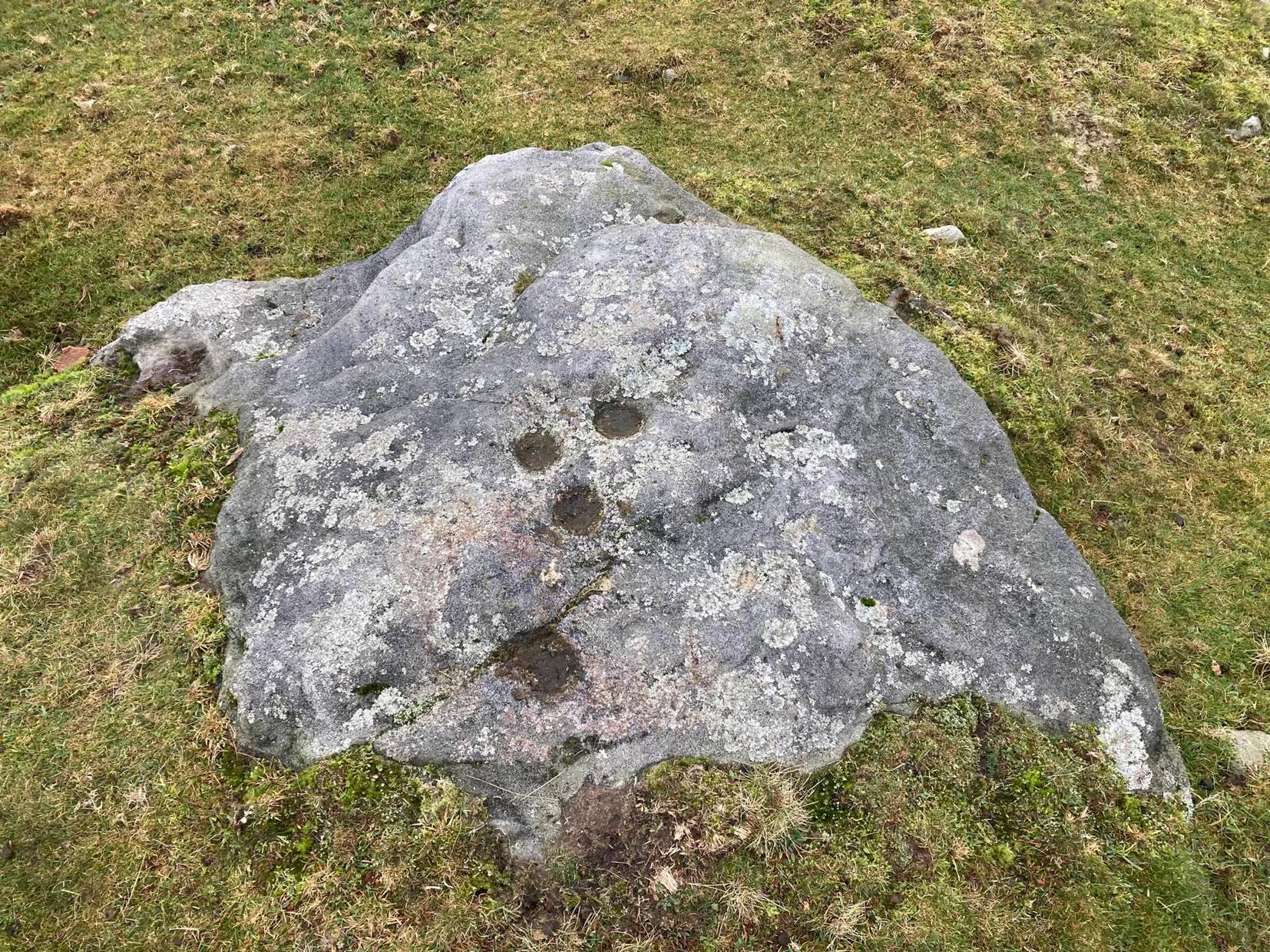
An intriguing find, made not too long ago by Jeff Wallbank of Silsden. Simplistic in design, it’s found on a small ridge of rocks adjacent to an old quarry (so there may have been other carvings here in times gone by), rising up immediately south of Haw Farm about 20 yards away, from where you can ask permission of the kind land-owner to have a look at the stone.
It’s pretty basic: consisting of a distinct triangle of three plain cup-marks on one side of a natural crack that runs across a section of the stone. Immediately adjacent and on the other side of this crack, is another singular cup. This appears to have a carved line running from it and possibly an elongated semi-circular element around the cup itself. It’s not too special when compared to the much more ornate petroglyphs further east, but is worth checking out if you’re walking in this gorgeous western edge of Rombalds Moor.
Acknowledgements: HUGE thanks to Sarah Walker, without whose help and permission to use her photos, this site profile could not have been written.