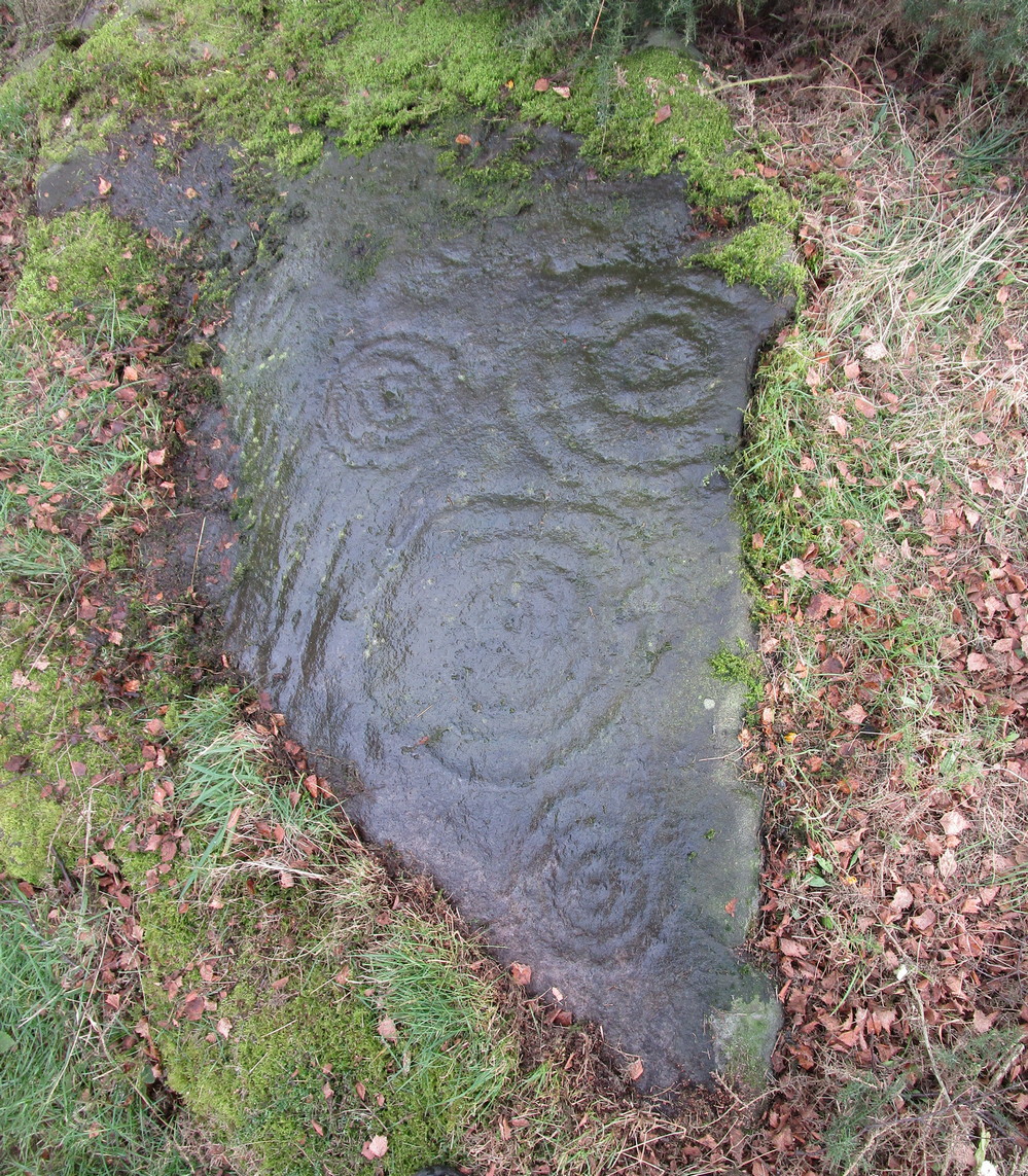
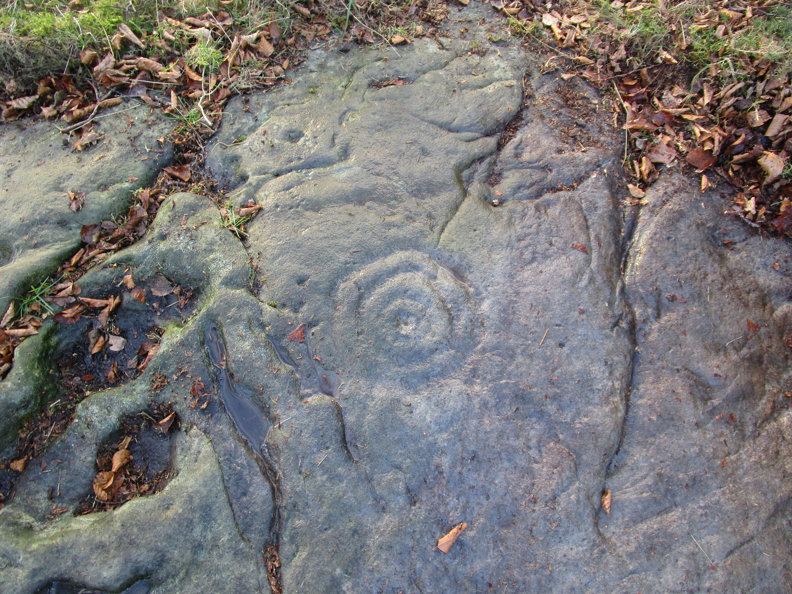
Cup-and-Ring Stone (lost): OS Grid Reference – NT 942 295
Also Known as:
Whitelaw Stone
Archaeology & History
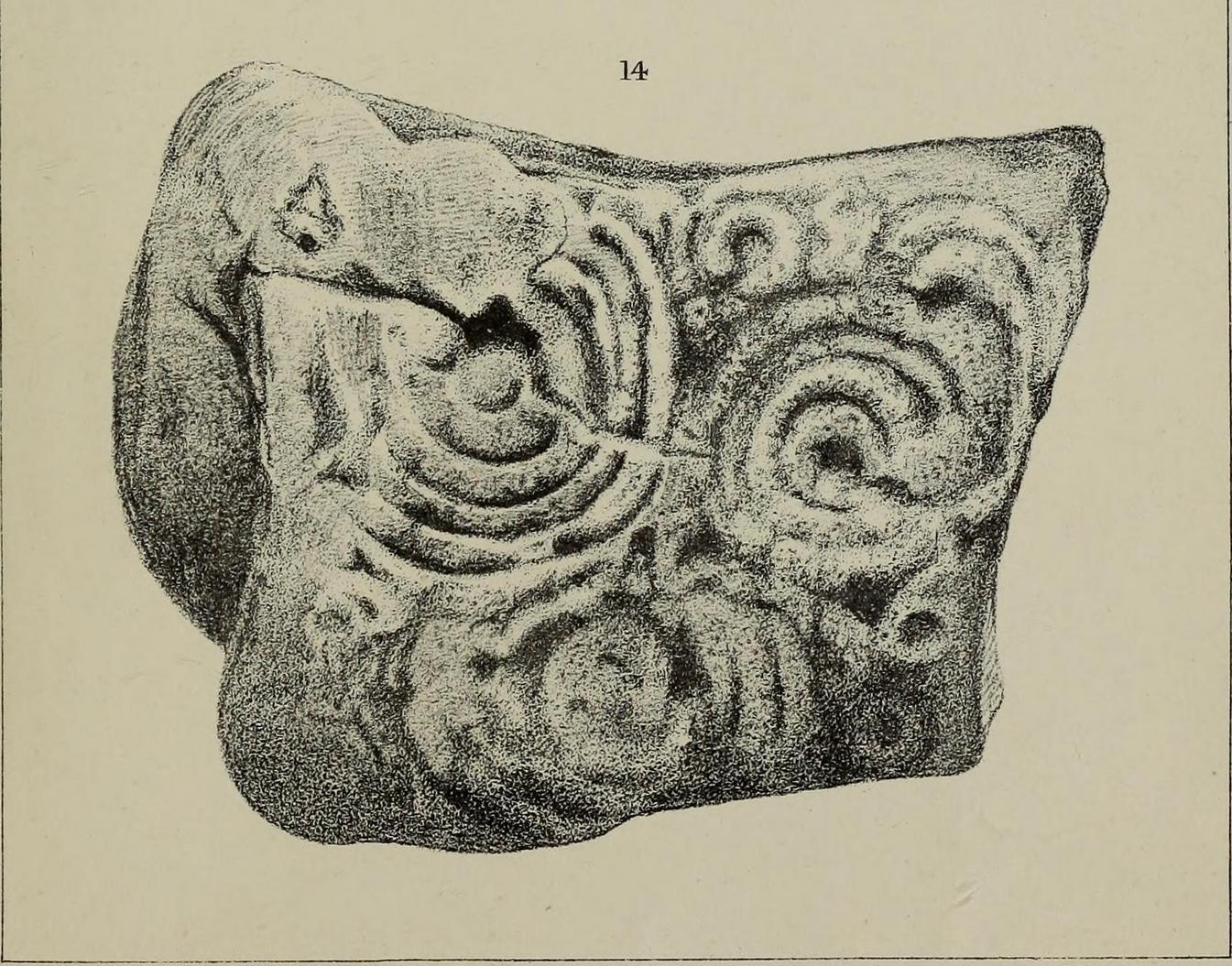
Sometime at the end of the 1860s, a local man—Mr William Wightman of Wooler—was in possession of this impressive-looking petroglyph which, we presume, he uncovered. The carved stone was, as we can see, broken off from a larger piece and so it’s very evident that this was originally a larger design than the one illustrated here in Mr Middlemass’ (1872) drawing. The only information we have about it are from his short notes,
The Whitelaw Stone
“was found on the north side of a hill called Whitelaw, the next eminence south-east from Yeavering Bell. The stone is a very hard gritty sandstone, and bears distinctly the tool marks by which the circles have been cut. The tool must have been of iron or bronze, as the material is too hard to be operated upon by stone implements; moreover, the tool marks shew that the instrument used had a sharp round point, and must have been held in a similar way to the modern chisel. The marks shew the size of the point. The object of the artist evidently has been to fill the stone with ornament as between the two great circles; and at the corners he has placed smaller circles to suit the space. The similar nature of the circles on all the stones hitherto figured would seem to show that such stones, if monumental, were not legendary, but, most probably of a religious character; serving, like the Christian cross, to invite the traveller to pay his devotions on a spot rendered sacred by the emblems of worship.”
Searches for this have been made by Stan Beckensall (1983) and his acolytes, but it remains lost. (the grid-ref is an approximation)
References:
Beckensall, Stan, Northumberland’s Prehistoric Rock Carvings – A Mystery Explained, Pendulum: Rothbury 1983.
Middlemass. Robert, “On an Inscribed Stone in the Possession of Mr William Wightman, Bank, Wooler,” in History Berwickshire Naturalists Club, volume 6, 1869-72.
Cup-and-Ring Stone (lost): OS Grid Reference – NT 269 419
Also Known as:
Kittlegairy Burn
Archaeology & History
Fred Coles’ 1898 sketch
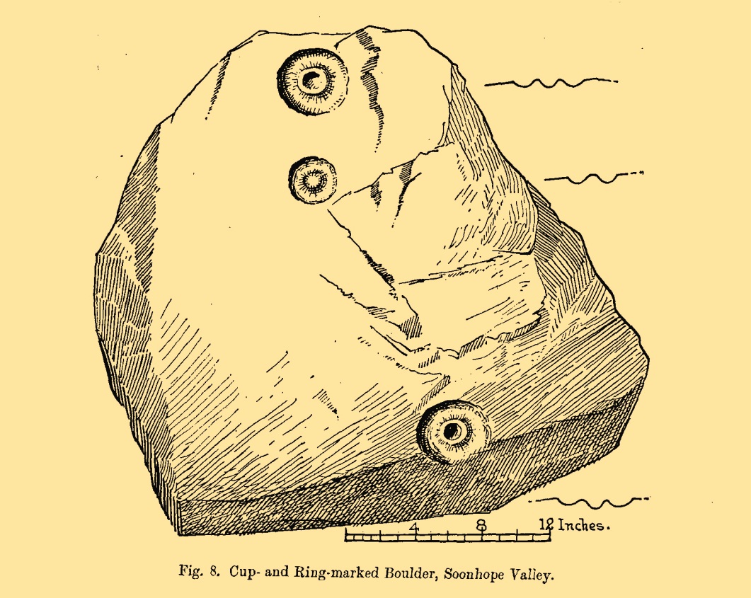
An apparently isolated cup-and-ring stone was found on the hills north of Peebles at the end of the 19th century by the renowned Scottish megalith explorer, Fred Coles. (1899) He was having a look at some of the hillforts in the area and—as some of us tend to do—he began meandering off-track, down streams, through bogs and as a result came across the carving that’s illustrated here. It’s subsequently become “lost” in the hills, but it shouldn’t be too difficult to locate, as the description he gave of its whereabouts is a pretty good one. He told us:
“A very little over one mile and a quarter up the valley, measuring from the road at Kerfield Cottage, a tiny rivulet called Kittlegairy Burn trickles down from the SE into the main stream. On the hill to its east, and about 450 feet higher, are the remains of a fort, one of a series of three crowning prominent heights along this side of the valley. Down the main stream from Kittlegairy Burn is a large ruined sheep-shelter called Soonhope. Nearly midway between these two points a deep curve has been hollowed out of the E. bank; and, at the foot of this rather high gravel bank, half immersed in the stream, lies the block of stone with the cup-and ring-marks. They were discovered, 14th September 1896, by my daughter, Helen, on crossing the stream; and we at once proceeded to make a measured drawing, a reproduction of which is given here…. The depth of the rings in proportion to their width is the one most noticeable feature; next, the extreme thinness of the intervening ‘neck’; but, on a minute and careful examination of the nature of the stone itself, taking into consideration that its angularity and sharpness of edge and the absence of moss or even of confervoid growths on its surfaces went against the possibility of its being truly waterworn.”
The rock had obviously fallen from its original position above the burn. Today, the entire area where this stone exists has been covered by a huge forestry plantation, but if any rock art fanatics from the Peebles area get bored one day and have nothing to do…..
References:
Coles, Fred, “Notices of the Discovery of a Cist and Urns at Juniper Green, and of a Cist at the Cunninghar, Tillicoultry, and of some Undescribed Cup-marked Stones’, in Proceedings Society Antiquaries, Scotland, volume 33, 1899.
Morris, Ronald W.B., “The Cup-and-Ring and Similar Early Sculptures of Scotland; Part 2 – The Rest of Scotland except Kintyre,” in Transactions of the Ancient Monuments Society, volume 16, 1969.
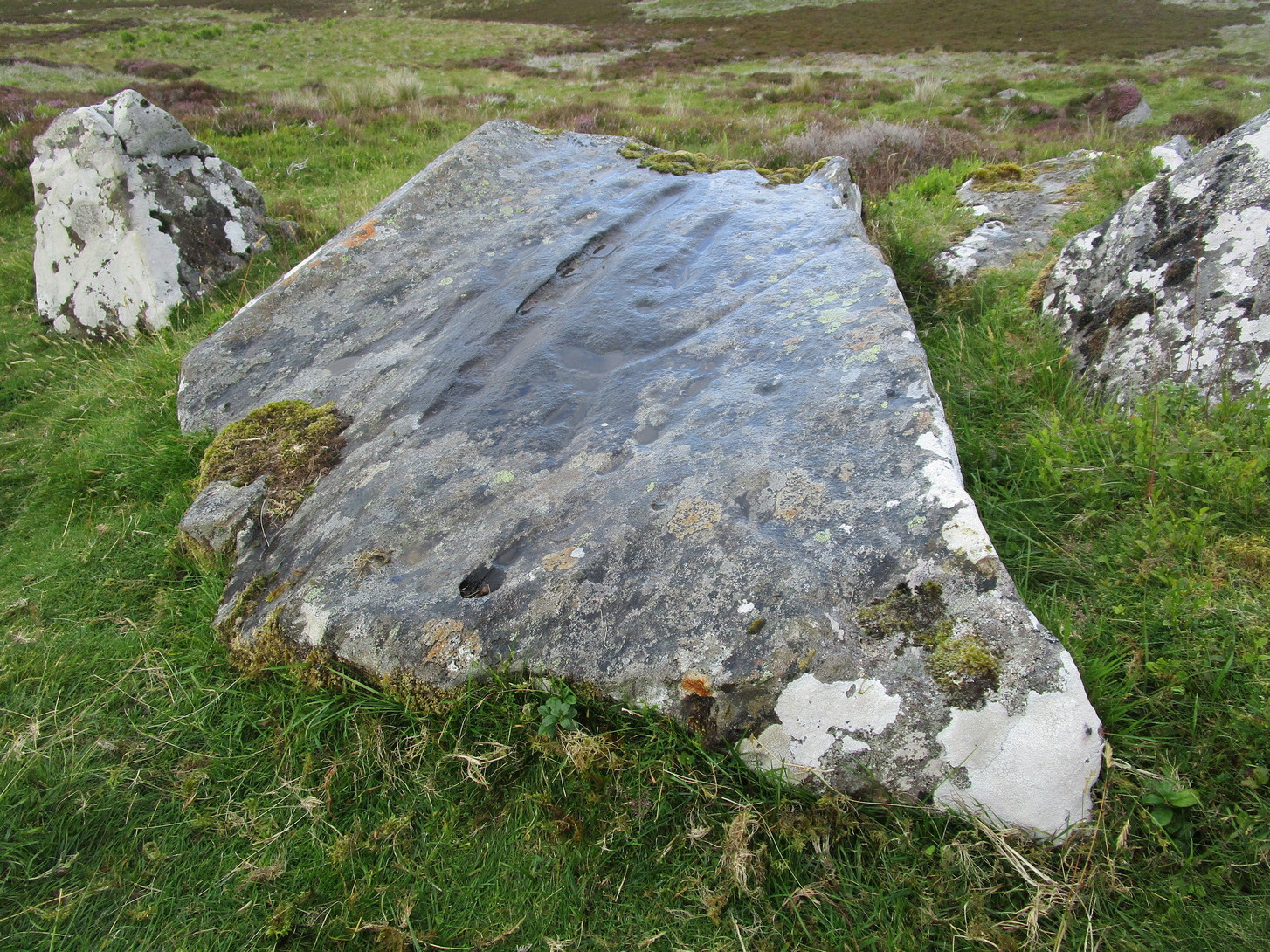
Follow the same directions to reach either the Craig Hill cluster (3), no.4 or no.5 carvings. Once here, looking at the sloping moorland ahead of you, the elongated stone that’s closest to where the moorland slopes downhill is the one you’re after. Y’ can’t really miss it!
Archaeology & History
The sixth carving in this small close-knit cluster and, design-wise, the least impressive of the bunch. There are three distinct cup-marks on the rock: two on its more southern side and one near the middle of the stone. There may be another two cups, but these may have been part of the curious long, naturally-eroded line running along the length of the stone. Other man-made elements may have been cut into the stone, but it needs to be seen in perfect low light to tell us one way or the other.
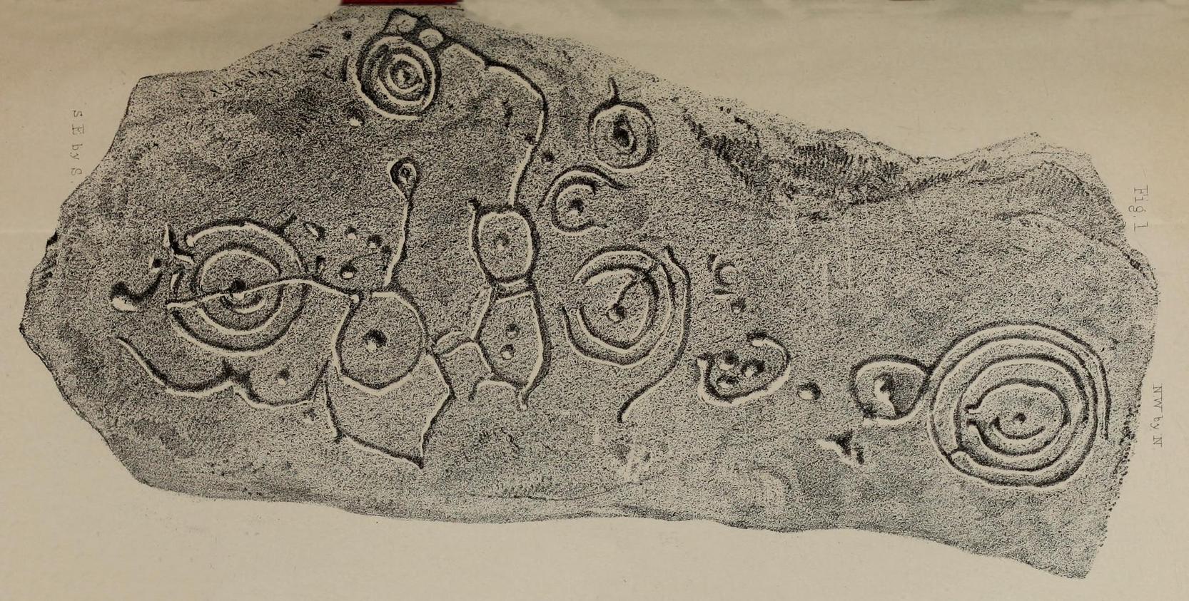
In 1863, a bunch of reputable Victorian authors and antiquarians met with the Duke of Northumberland in Alnwick Castle to discuss the matter of making decent images of the petroglyphs which, at the time, had only just been rediscovered in the area. At one of their meetings, the floor in one of the Castle rooms was covered with rubbings of carvings that they’d made—this one included. I’d loved to have been there! Subsequently, from that meeting, sketches of this carving were done and included in the works by George Tate (1864; 1865) and then a few years later in J. Collingwood Bruce’s (1869) rare tome that had been published with the help of dosh from the Duke.
Found along a raised geological ridge running roughly east-west, a number of other carvings are close by and well worth looking at when you visit here. The basic (and first) description of the site by Tate told that here,
Tate’s 1864 sketchJ.C. Bruce’s 1869 image
“on a high ridge on Hunter’s Moor, a large surface of rock, some forty yards by twenty, having a gentle slope to the northward, is partially uncovered. In one part, which has been entirely cleared of turf, fourteen figures are scattered over an area of 15 feet by about from 5 to 7 feet. Some of the figures are of the common type, one of which is 28 inches in diameter; but others present new features; and several are curiously united by straight and curved grooves. Across the entire diameter of a group of four concentric circles, runs a groove connecting them with other combined figures. An irregularly shaped, rounded, angular figure, encloses two hollows or cups; and united to this is a broad oval figure. One figure around four cups approaches to the reniform.”
When the modern rock art expert Stan Beckensall wrote about this site, he mentioned how his own picture of the carving consisted of a number of elements that weren’t included by the 19th century pioneers—which isn’t unusual.
References:
Beckensall, Stan, Northumberland’s Prehistoric Rock Carvings – A Mystery Explained, Pendulum: Rothbury 1983.
Beckensall, Stan, Prehistoric Rock Motifs of Northumberland – volume 1, Abbey Press: Hexham 1991.
Bruce, John Collingwood, Incised Markings on Stone; found in the County of Northumberland, Argylshire, and other Places, privately printed: London 1869.
Tate, George, “The Ancient British Sculptured Rocks of Northumberland and the Eastern Borders,” in Proceedings of the Berwickshire Naturalists Club, volume 5, 1864.
Tate, George, The Ancient British Sculptured Rocks of Northumberland and the Eastern Borders, Henry Hunter Blair 1865.
To reach here from Stirling or Bannockburn, take the B9124 east to Cowie (and past it) for 3¾ miles (6km), turning left at the small crossroads; or if you’re coming from Airth, the same B9124 road west for just about 3 miles, turning right at the same minor crossroads up the long straight road. Drive to the dead-end of the road and park up. You’ll notice that this is a crossroads of dirt-tracks. Walk along the one that heads to the houses you can see on a rise above the fields, eastwards. About 300 yards on, instead of going up towards the houses, walk thru the gate and along the wall-edge for 85 yards and go thru the gate to your right. You’ll see a small rise covered in gorse trees 100 yards in front you and roughly in the middle of it all, you’ll find this carving.
Archaeology & History
The naked stone
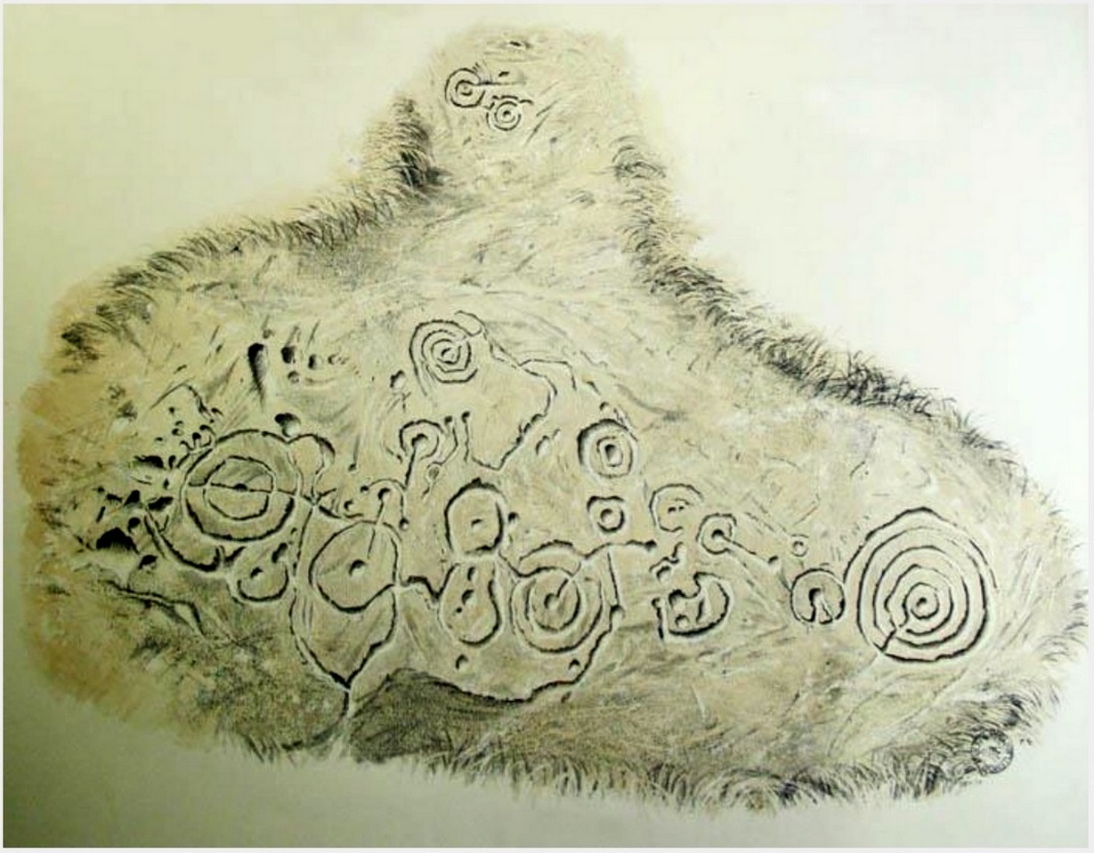
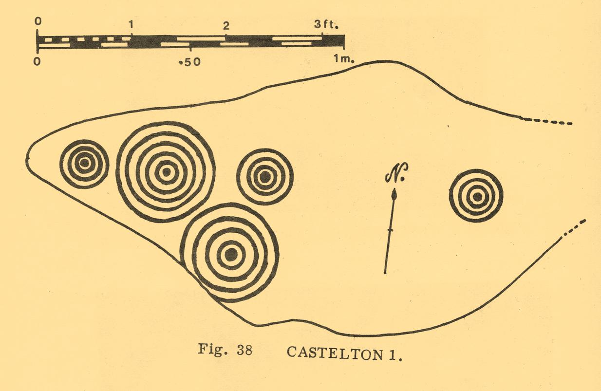
When John Bruce (1896) wrote his article on the mighty Cochno Stone a few miles north of mighty Glasgow, he left some end-notes about a petroglyph near Carnock (near Castleton) that was “found to bear a few much weathered cups with concentric circles.” He wasn’t at all clear where the carving was located, merely telling that it was “in the Gosham Park” area on the Carnock estate. This vague description was probably the reason why, when the lads from the Royal Commission came looking for it in August 1955, they left without success. Nevertheless, when Ron Morris (1981) explored this area he located the place-name of Gosham Field and, therein, this multi-ringed carving. It seems more than likely that this was the carving described by Mr Bruce – and it’s an impressive one!
Despite being eroded by the passage of time, the carved design is still pretty easy to see, comprising a cluster of archetypal cup-and-multiple rings in close proximity to each other, etched onto a sloping stone. Ron Morris’s (1981) description told that, 125 yards east of Gosham Field’s western wall,
“is a prominent greywacke outcrop, part of a rocky ridge running NW-SE, exposed in 1969-75 for 3m by 2m (10ft x 6ft), 4m (12) high on its S, but at ground level elsewhere, sloping 15° NE. On its fairly smooth surface are:
“5 cups-and-complete rings, with no grooves, 3 with three rings, 1 with four, and 1 with five rings, up to 36m (14in) diameters and 1cm (½in) depth.”
Ron Morris’ 1981 sketch
Yet contrary to Morris’ description, there are some “grooves”, or carved lines emerging from some of the rings; faint but definitely there. You can make them out in the accompanying photos above. (are there any sketch artists out there could accompany us to these carvings, so we get some good portraits of the stones?) When Maarten van Hoek (1996) visited this carving he also missed these ‘ere carved grooves.
An additional feature that needs to be mentioned is the cluster of small geological deep natural cups, inches away from the carved rings on the southern edge of this stone (completely covered in vegetation in the attached photos). The same feature also exists on the southern edges of the Castleton 5, Castleton 6 and Castleton 12 carvings and it probably had some mythic relationship with the petroglyph.
There’s another cup-marked stone about 30 yards east of here, along this same geological ridge. It was previously covered in gorse, which was thankfully removed following a fire caused by the hot weather at one of the other carvings, preventing a cracking of the rock which would damage the carvings. All of the rock surfaces in the Castleton complex need to be laid bare to enable a greater visual experience of the wider Castleton complex and to prevent them being damaged by the gorse roots cracking the rocks, as well as stopping fires which will also damage these vitally important petroglyphs. People in the Cowie area want to see and experience their own local history…
Morris, Ronald W.B., The Prehistoric Rock Art of Southern Scotland, BAR: Oxford 1981.
Ritchie, Graham & Anna, Edinburgh and South-East Scotland, Heinemann: London 1972.
Royal Commission on the Ancient and Historical Monuments of Scotland, Stirlingshire: An Inventory of the Ancient Monuments – volume 1, HMSO: Edinburgh 1963.
Royal Commission on the Ancient & Historical Monuments of Scotland, Archaeological Sites and Monuments of Stirling District, Central Region, Society of Antiquaries of Scotland 1979.
van Hoek, M.A.M.,”Prehistoric Rock Art around Castleton Farm, Airth,” in Forth Naturalist & Historian, volume 19, 1996.
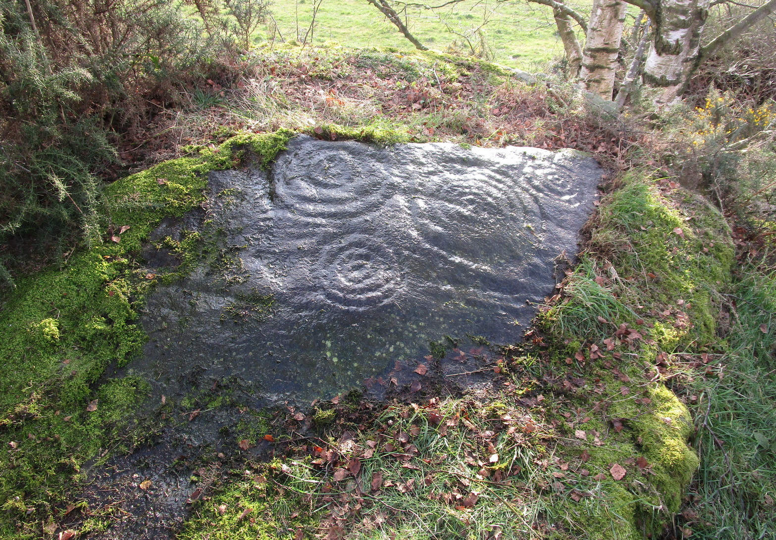
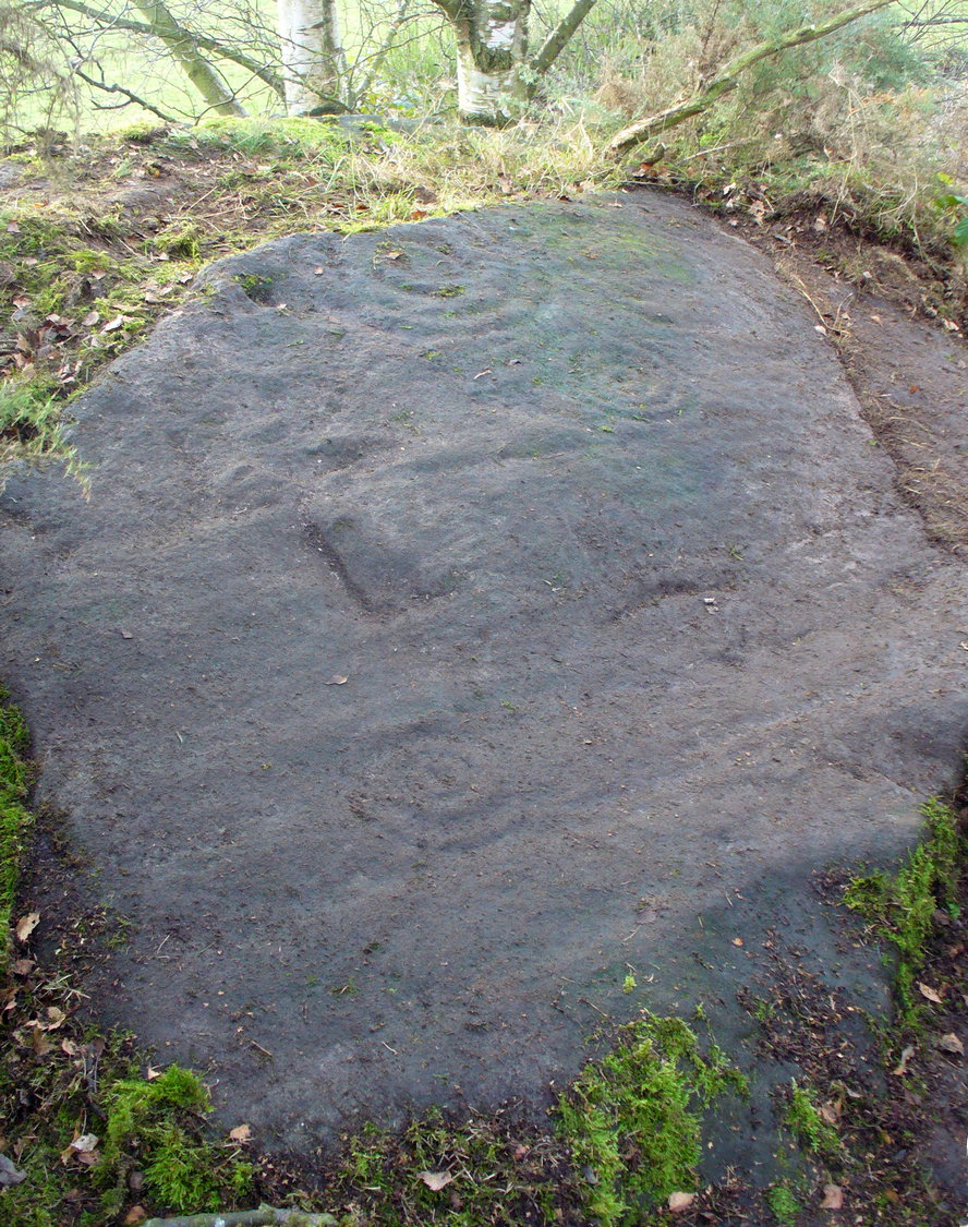
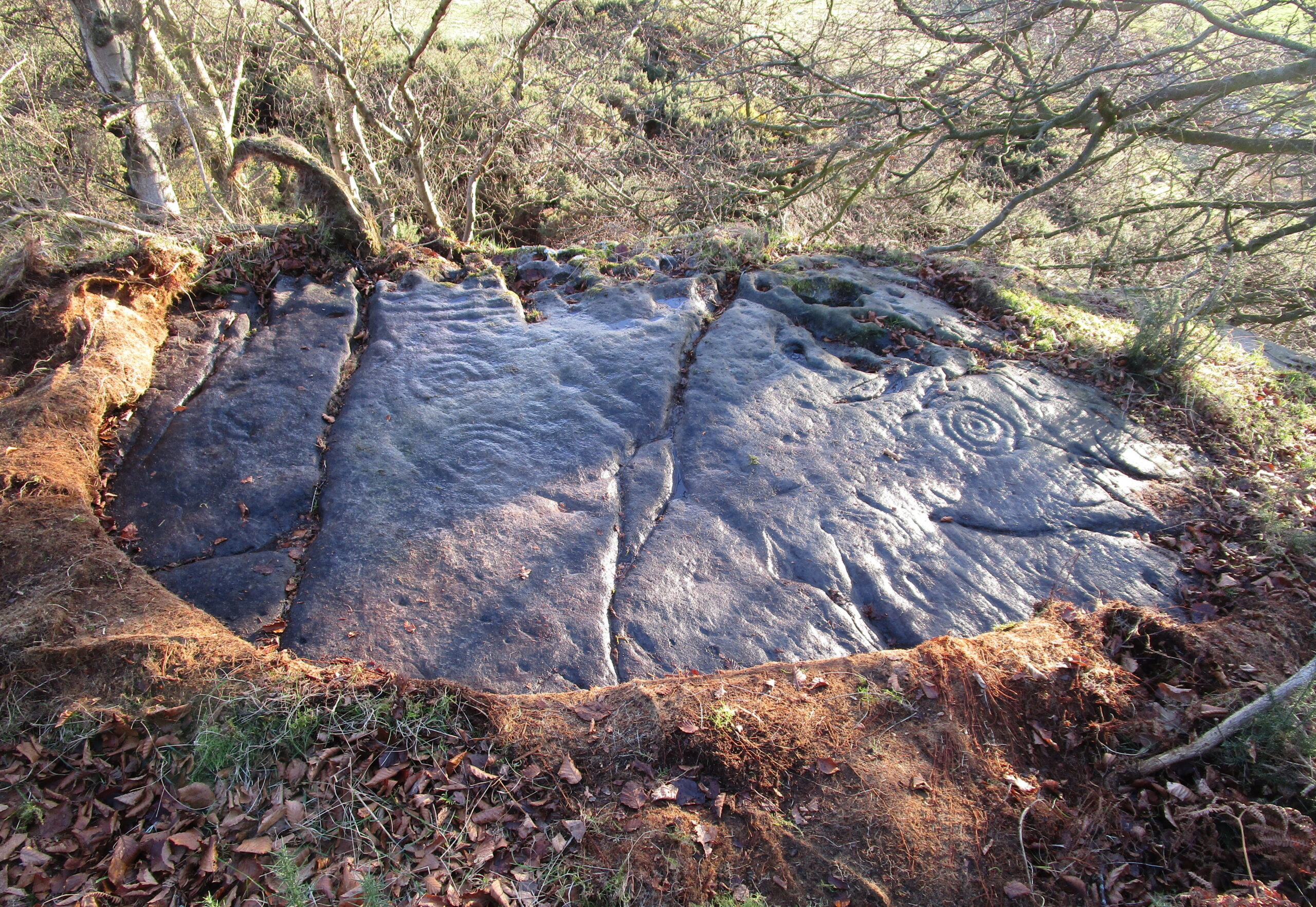
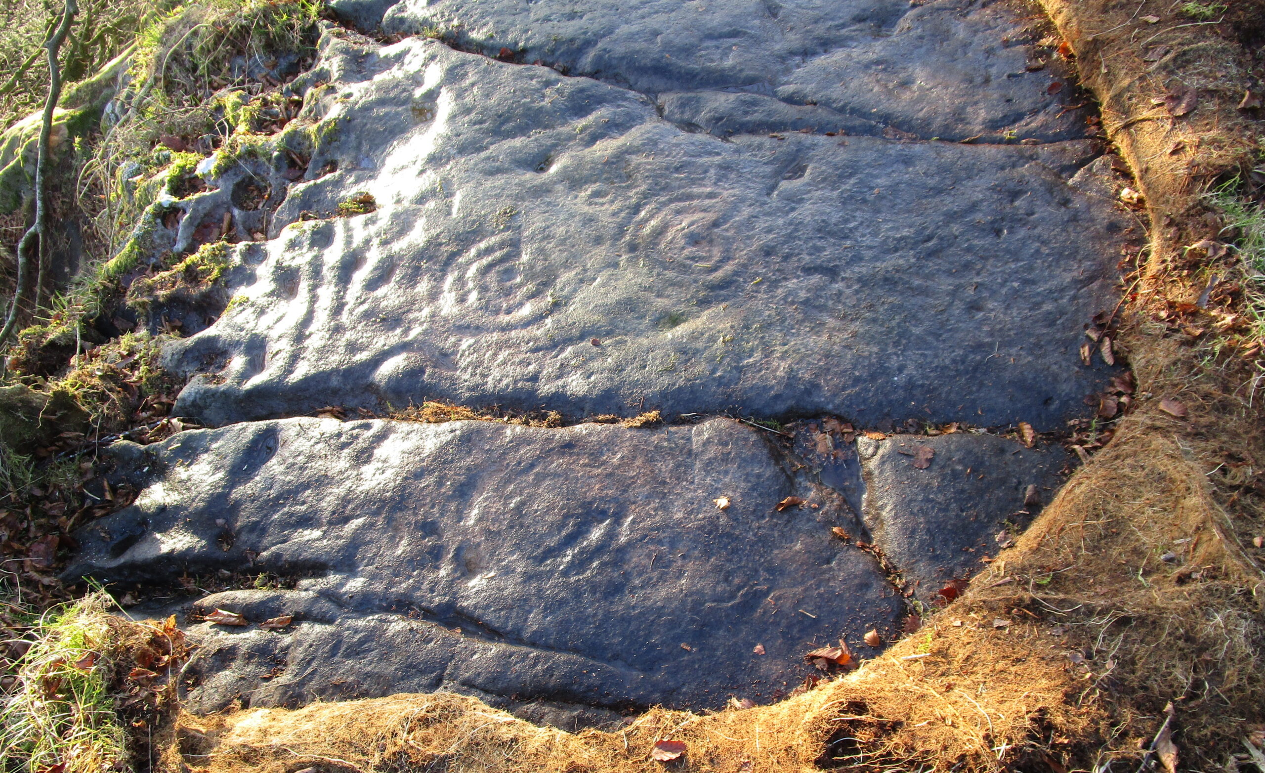
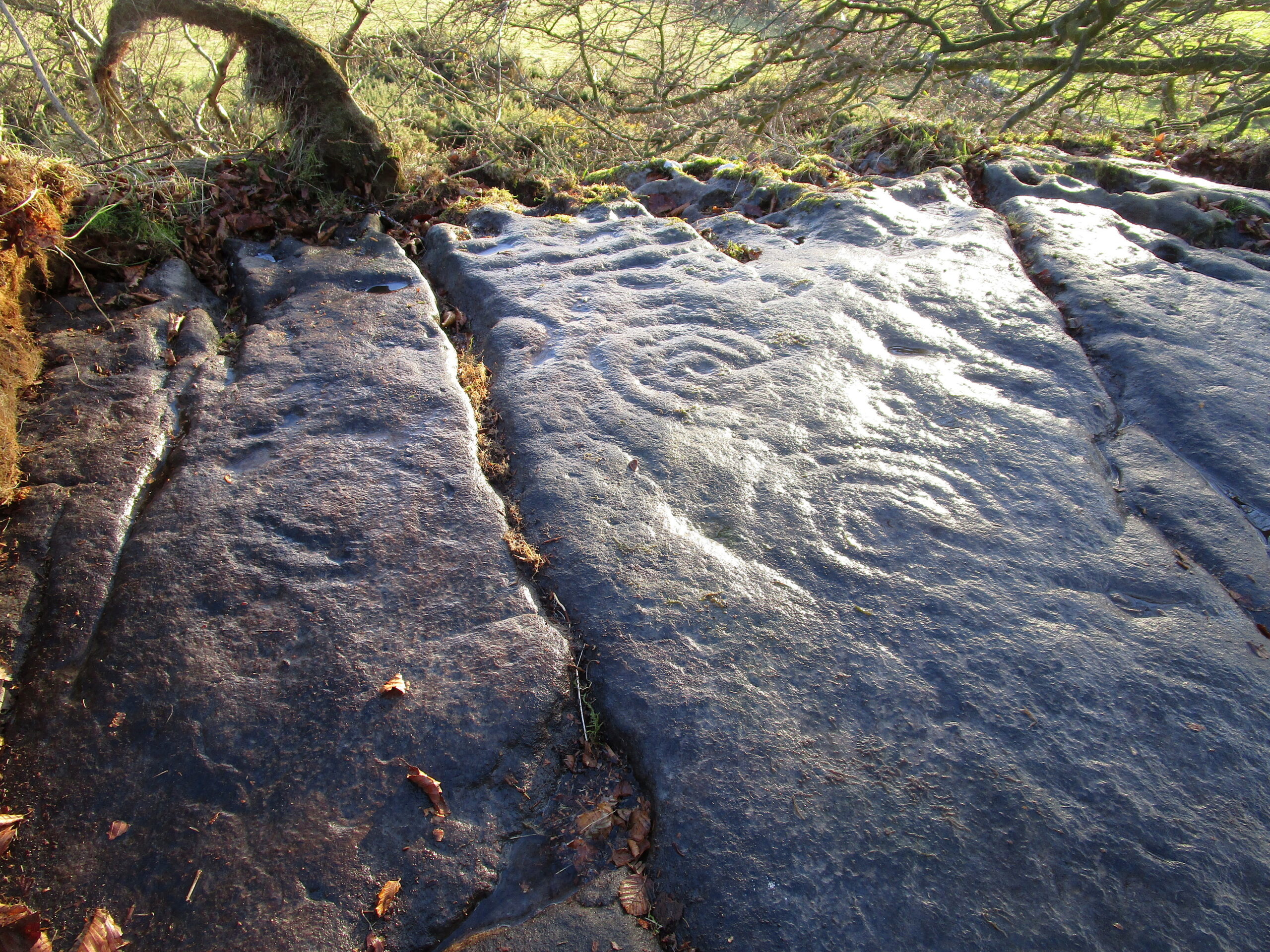
Located near the top of one of Castleton’s rocky island outcrops and overlooking extensive flatlands many miles to the south, this impressive multi-ringed carving was rediscovered in May 1985 by the Ordnance Survey lads and, I believe, was first described in an article by Maarten van Hoek (1996), whose description we’ll get to shortly. It’s a design that incorporates some of Nature’s own cup-marks alongside the marks of men.
The overall design here is captured within three sections of the rock: between three large natural cracks running roughly north-south, as clearly shown in the accompanying photos. It’s a multi-period carving, executed over what seems to be a considerable period of time—probably several centuries. I base this on the differing degrees of erosion between the respective multiple rings — a factor found several of the Castleton carvings.
Eastern & central cup ring symbolsCloseup of central rings
One of the most eroded sections can be seen on the eastern side of the rock, where a very faded cup-and-three-rings was carved. Initially it looked as if there was no central cup to this, but as I looked across this towards the falling sun, what seemed to be a possible ‘dot’ was noticed in the centre, very faint indeed. There are several single cup-marks just a few inches east of this triple-ring, which look more recent than its eroded companion.
On the other side of the long natural crack we see two quite distinct multiple cup-and-rings: one with three rings and another with four, both of which have short carved lines running from their centres westwards. Between these, a smaller single cup-and-ring nestles quietly, almost innocuously, minding its own business! But below these two large multiple-ringers there’s a very faint cup-and-double ring, only visible when the light conditions are just right. In numerous attempts I made to catch this element in my photos, none were successful. (I’m a crap photographer, which doesn’t help!) Due to the erosion on this element, this is possibly the earliest section of the carving. Above these rings, close to the edge of the small cliff, one or two carved lines can be seen that run into natural ‘bowls’ which, in all probability, were of some significance to those who made this design. In cultures outside the UK, such elements have sometimes been afforded mythic importance.
Several other natural small ‘bowls’ exist above the most blatant of the cup-and-rings here, on the west side of the rock, which consists of a cup-and-triple-ring no less. Erosion levels on this would seem to suggest that it was the most recent element of this petroglyph.
When Maarten van Hoek (1996) wrote his report, there was much less vegetation covering the stone and another cup-and-ring could be seen on the northernmost section of the rock – as his sketch here shows. He wrote:
Westernmost elementvan Hoek’s 1996 sketch
“Near the edge are five cup-and-rings and possibly up to four single cups, all on rock sloping about 6″ to 12″ NW. The easternmost set consists of the worn remains of three rings (the innermost hardly visible) without a distinct central cup. Across a crack is a cup with four rings, the outer incomplete and curving away; another cup with four rings, mostly incomplete. A small cup-and-one-ring sits in between. South of this group may be some grooves and a single cup, all doubtful being very near the cliff-edge which is heavily pitted by erosion. The westernmost cup with three ovalish rings is the best preserved set of the group. Further away from the scarp is one single cup on a horizontal part and even further N is a cup-and-two-rings on a part sloping 6″ SW.”
It would be good to completely clear this rock and make it all visible again, as it was long long ago…
References:
Morris, Ronald W.B., The Prehistoric Rock Art of Southern Scotland, BAR: Oxford 1981.
van Hoek, M.A.M.,”Prehistoric Rock Art around Castleton Farm, Airth,” in Forth Naturalist & Historian, volume 19, 1996.
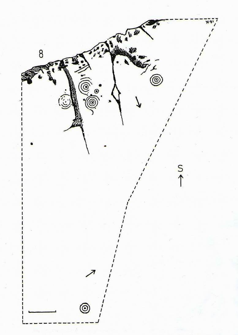
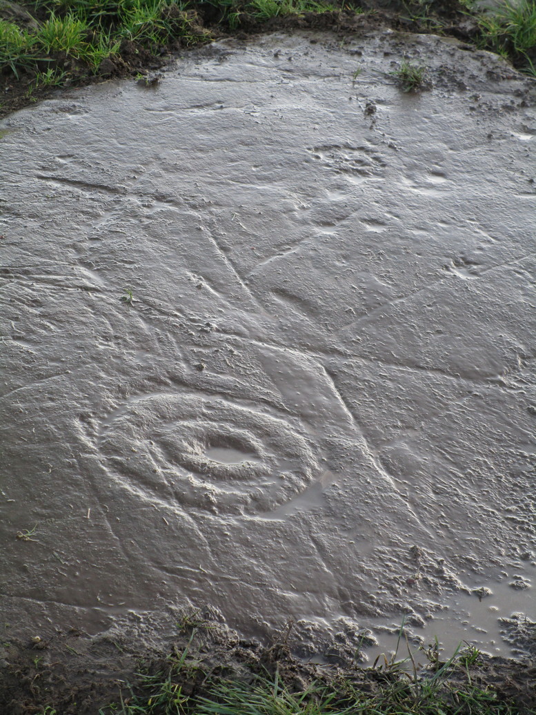
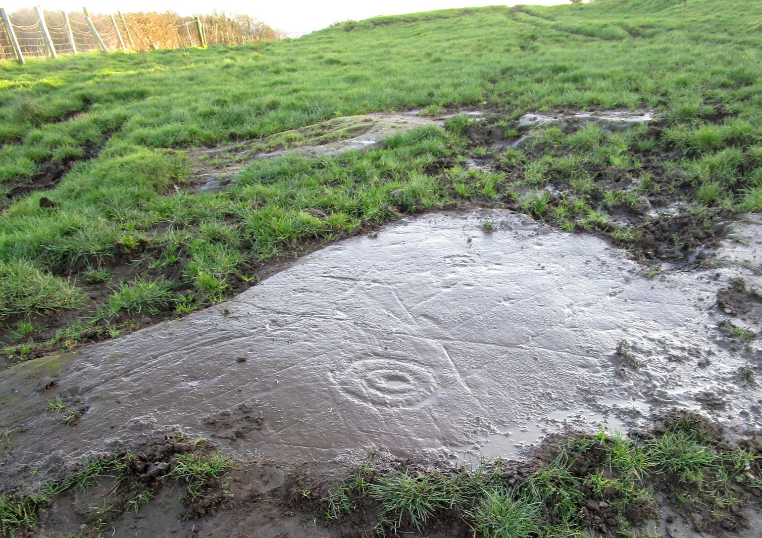
Amidst the cluster of at least twenty petroglyphs found at Castleton, this example close to the fence 60 yards southeast of the farmhouse, wasn’t included in the earlier surveys by Morris (1981) and van Hoek. (1996) At this spot there a large smooth sloping rock broken into separate parts with natural cracks running over it at different angles, partially covered in soil. The stone faces north. On the easternmost side there exists a number of carved symbols, most notable of which is a large double cup-and-ring. You can’t really miss it! The other elements however, can be a little more troublesome to see…
Cup, rings & crossCastleton 11 carving
A curious motif is the quite notable ‘cross’ that’s been pecked onto the stone, above the primary cup-and-ring. This cross is probably a later addition to the petroglyph, perhaps added to christianize the original mythic function. From the cross, it looks as if a curved line has been carved down towards the double-ring, nearly linking them together, which could also be viewed as a movement from the pre-christian to the new christian meaning conferred upon the stone. …Just an idea…
It should be noted that a faint cross was also cut into natural cracks in the Castleton 2 carving, 380 yards northwest of here.
There are two more cup-and-rings on the stone, both on the right-hand side of the cross. These were carved quite separately over large periods of time, as evidenced by their degrees of erosion. One cup-and-ring (if you can call it that) is a somewhat erratically executed series of peck-marks that strives to join up with each other, almost failing miserably, creating a somewhat disjointed cup-and-ring. Next to this, but much much fainter, is a cup-and-half-ring that was obviously carved decades, if not centuries earlier. You can just make them out in the two photos here, to the right of the cross.
Carving in negative
Another very faint cup-and-half-ring also exists to the left of the primary motif that was only visible from one or two angles when we visited the place the other day, but barely shows up on any of the photos we took. There are a number of single cup-marks, mainly between the double-ring and the smaller cup-and-rings, some of which are probably natural, but several seem to have been worked upon by human hands.
A now-hidden petroglyph—known as “Castleton-3” in the Morris and van Hoek surveys—consisting of multiple cup-and-rings, exists beneath the mass or gorse bushes about forty years to the southwest. We could do with cutting this back so we can see the carving again.
References:
Morris, Ronald W.B., The Prehistoric Rock Art of Southern Scotland, BAR: Oxford 1981.
van Hoek, M.A.M.,”Prehistoric Rock Art around Castleton Farm, Airth,” in Forth Naturalist & Historian, volume 19, 1996.
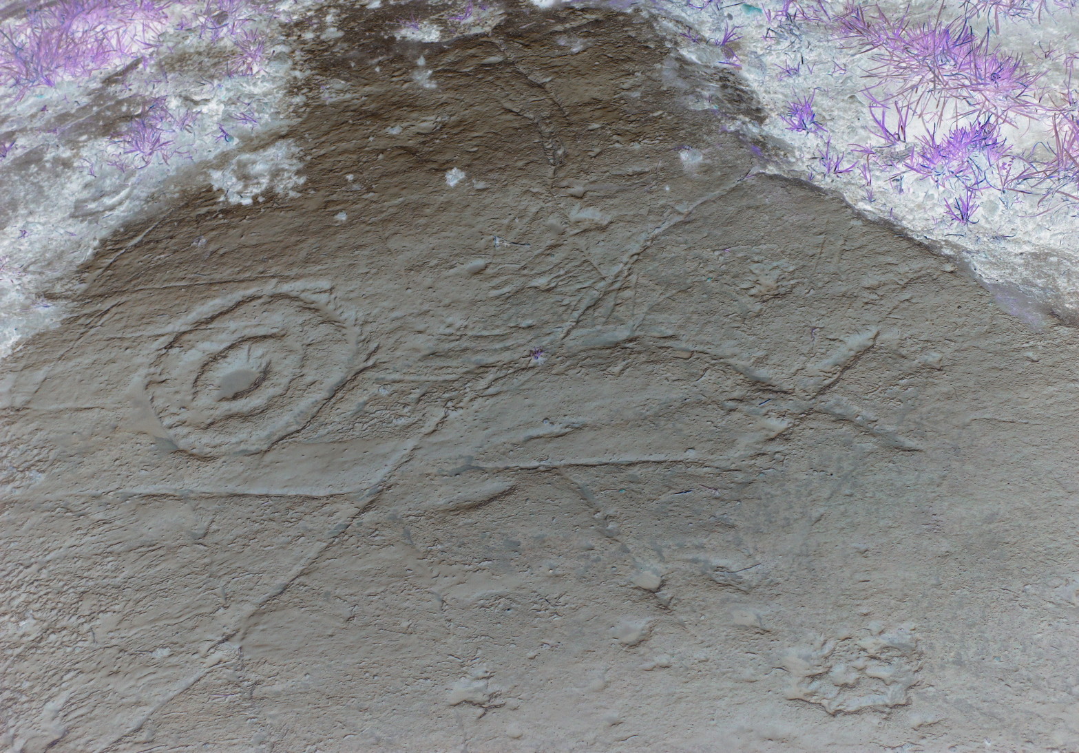
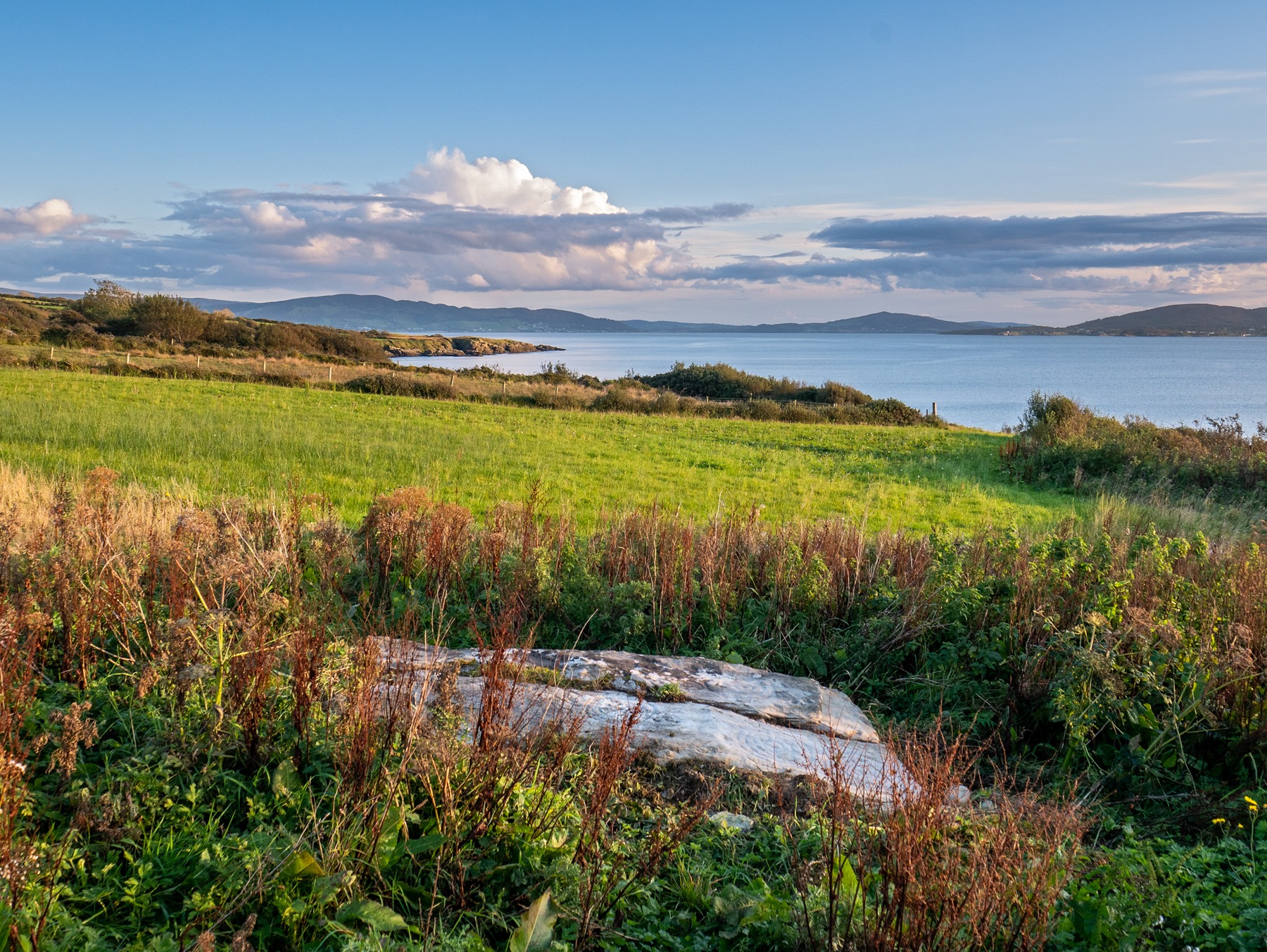
Cup-and-Ring Stone: OS Grid-Reference – C 30754 37541
Archaeology & History
Incredible setting -incredible carving
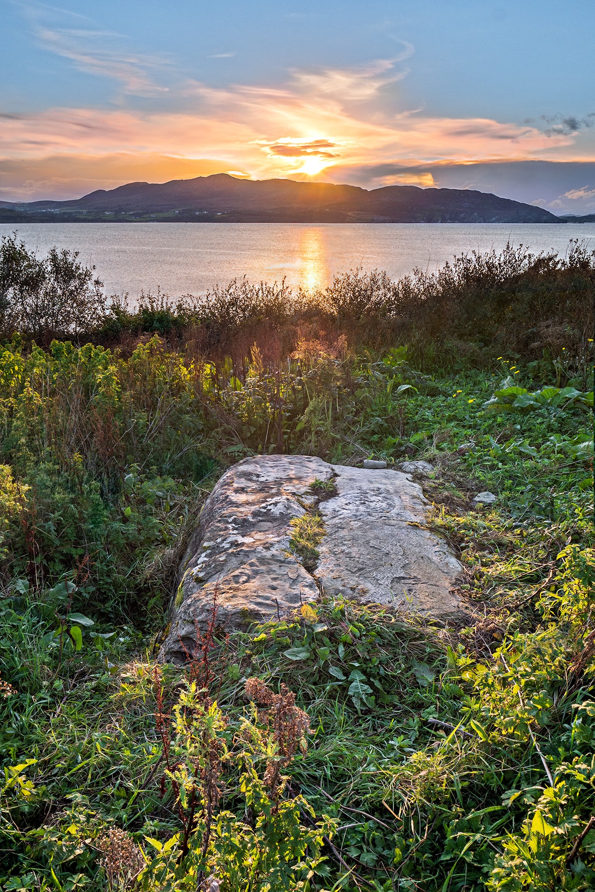
This is an incredible find—dare I say a beautiful find—uncovered beneath the soil a few years ago on farmland close to the shore of Loch Swilly by one of the farm-workers. We were lucky inasmuch as when it was found he noticed curious markings on it. Informing the farmer, between them they peeled back the rest of the soil and found the incredible carving that we see here in Bettina Linke’s photos.
Etched onto a sloping stone overlooking the blue panorama that is Loch Swilly, this petroglyph has a 180º view of the landscape, from the southeast through to the northwest. This panorama—unimpaired by trees thanks to its proximity to the sea loch—was probably an important ingredient in the mythic function of the carving and is something we’ll return to shortly…
Local rock art specialist, Liam McLaughlin was informed of the discovery and, along with Bettina Linke, they met up with the farmer who showed them the carving. I have little doubt that they were very impressed by what lay before their eyes! They told that the rock,
“is aligned east-west with the visible motifs, apart from a few cup marks, situated at the western end of the outcrop. Interestingly, the northern half/leaf is little worn and individual peck marks, made millennia ago, are clearly visible, suggesting it may have been covered for most of the time. The southern half is clearly worn and smoothed out and therefor appears to have been exposed for a considerable amount of time.”
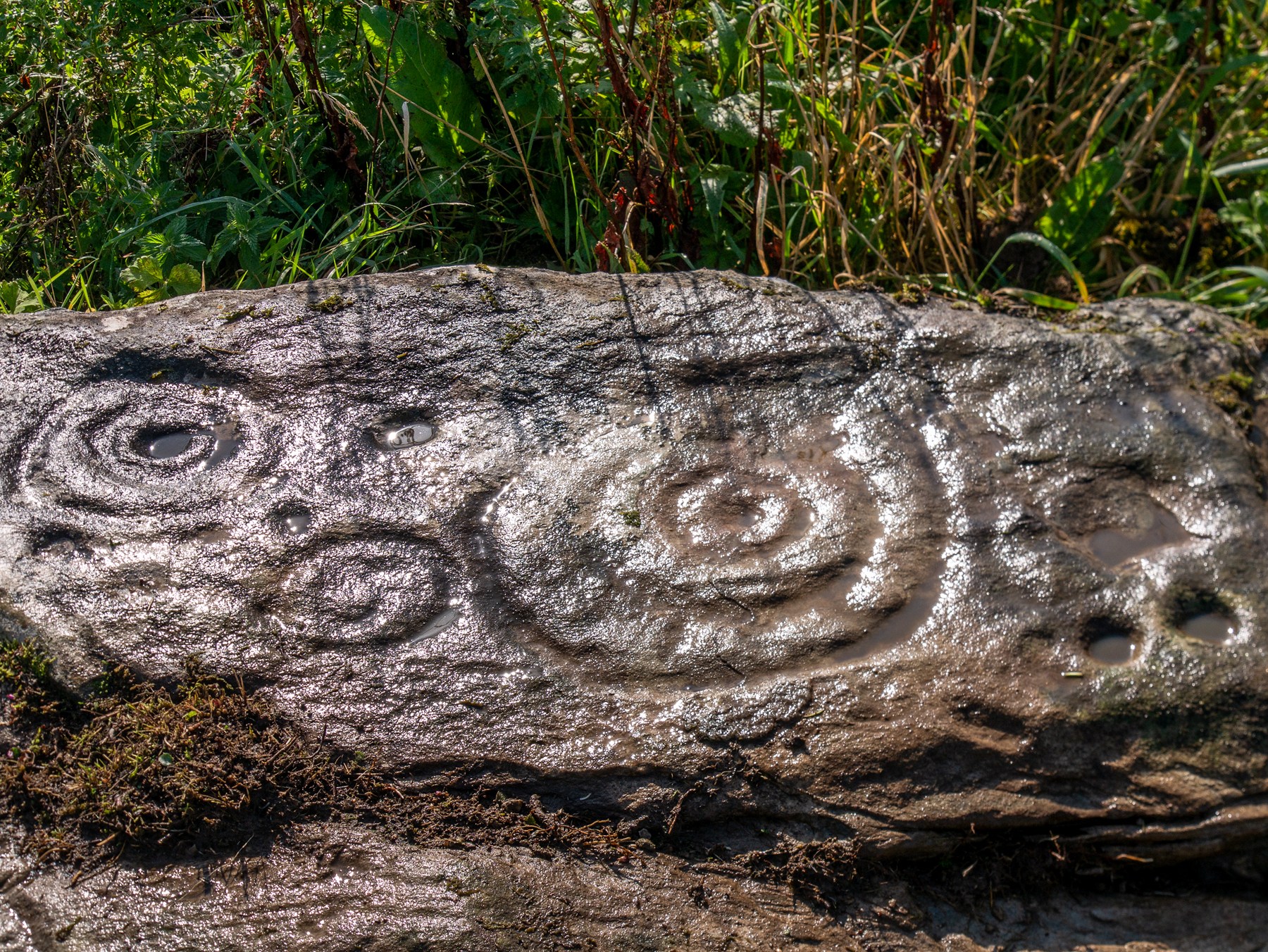
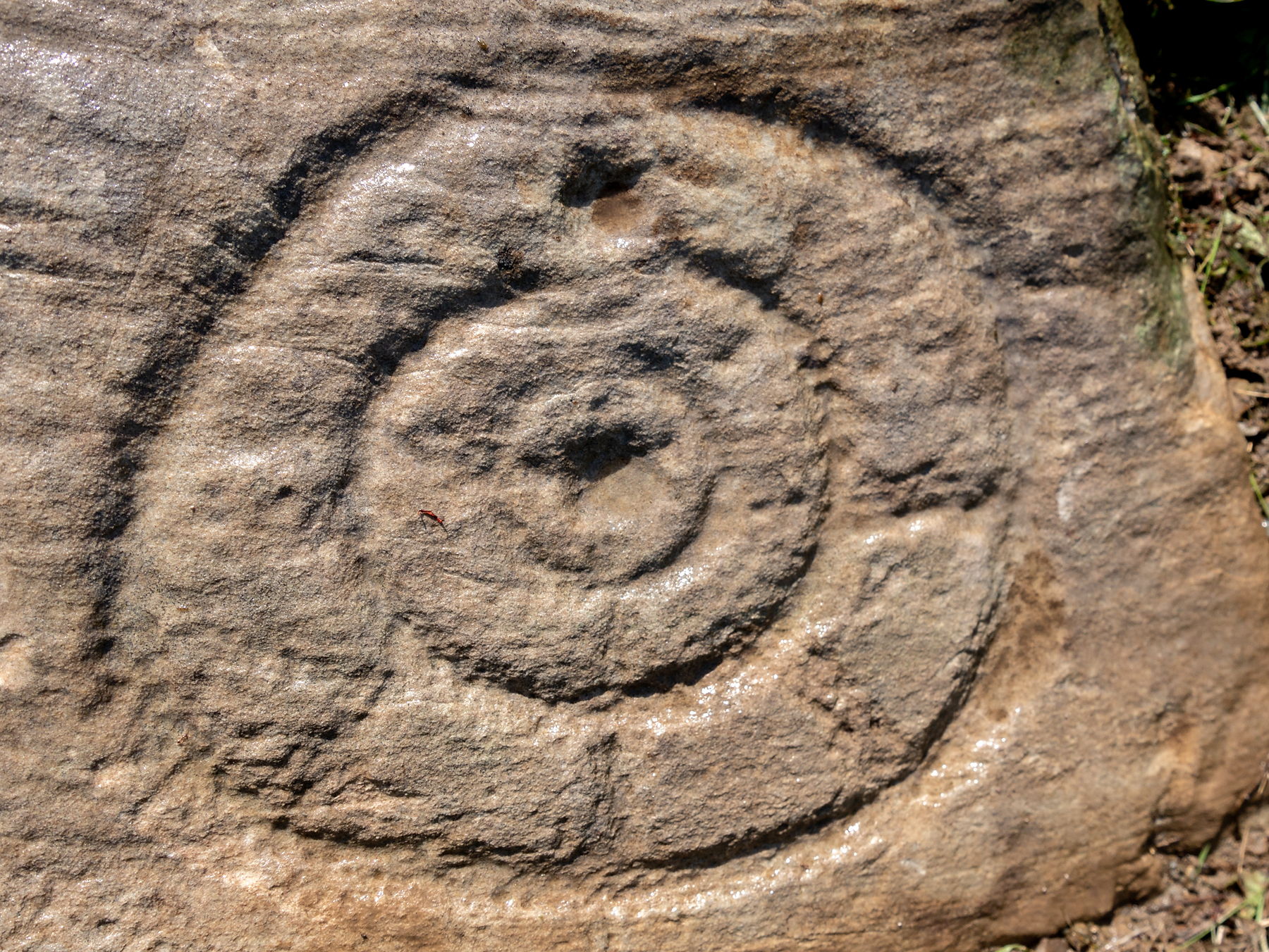
Archetypal cup-and-ringsAncient solar motif?
One of the most impressive elements in the overall design is the solar motif, i.e., a series of concentric rings (in this case three) with a number of ‘spokes’ reaching outwards as if to indicate the rays of the sun itself. This is shown clearly in one of Bettina’s photos here. This symbol is found on other neolithic carvings in Ireland: not least the incredible designs in the Newgrange complex where the solar alignment is unmistakable.
The discovery of the carving was reported to the Irish National Monument Service and added to the Heritage Environment Inventory where a detailed report was subsequently written, much of which is extracted here:
“The rock art panel is on an outcrop of bedrock, aligned east to west and slightly sloping in this direction towards Lough Swilly and Knockalla Mountains, also known as the Devil’s Backbone. It lies in an arable field near a field wall in rough ground. Visibility is good to the SE, S, W, and NW across Lough Foyle and the Fanad peninsula.”
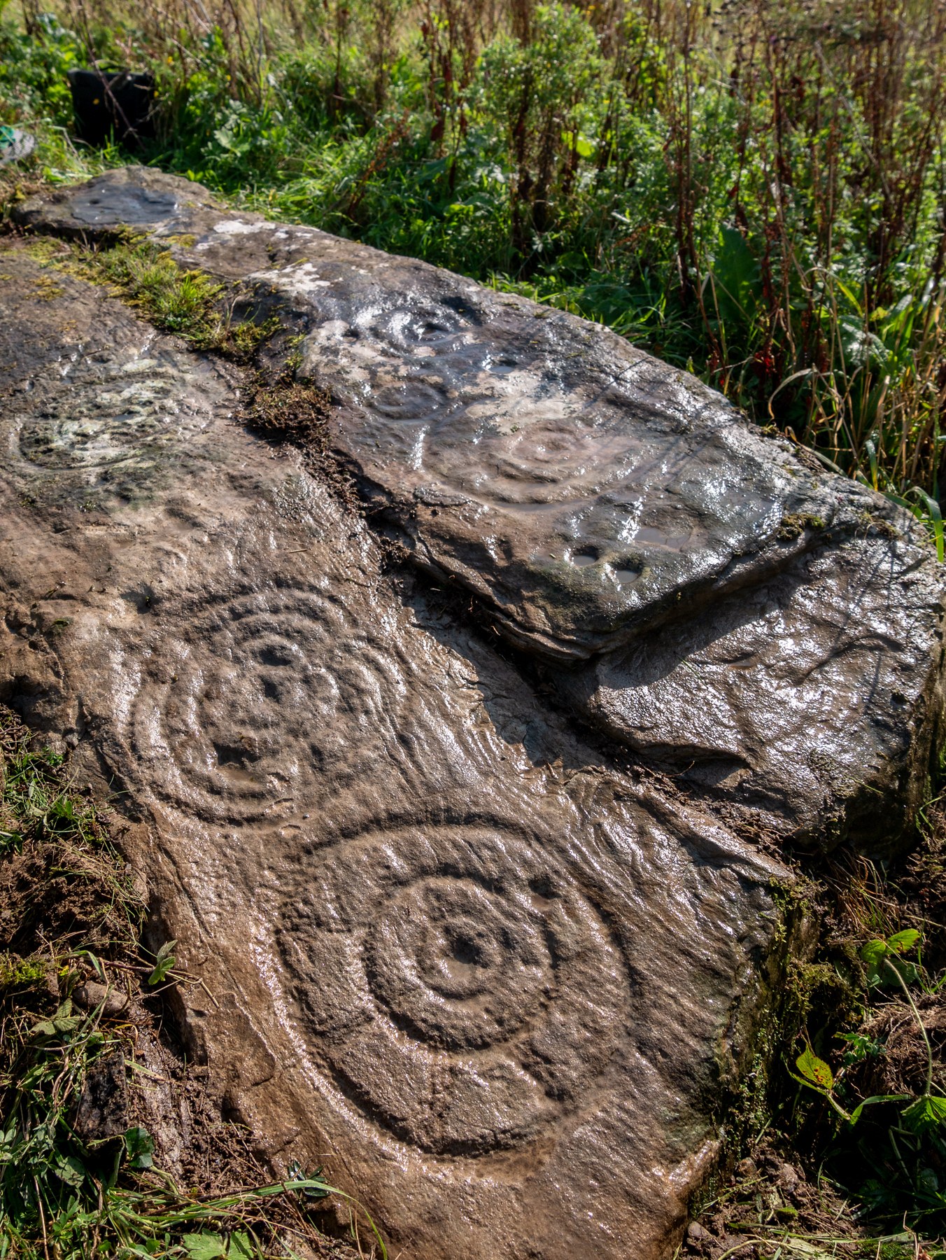
On the northern section of the stone,
“There are three large motifs and well preserved with cup and pecking marks between them. There are traces of a fourth large motif on the east end but the rock surface has been eroded or damaged, making it impossible to ascertain the design of the motif.
“Starting from west to east, the top large motif has three rings and a diameter of 43cm. The centre cup mark is shallow and has a diameter of 5cm. There is second shallow cup mark between the 2nd and 3rd ring in the southern part of the motif. Its diameter is 3cm. One tail, is running from the inner ring outwards to the west and a second one is running towards the north. Peck marks, covering the motif, are still visible, particular in the rings.
“The motif below has four rings and a diameter of 39cm. The centre cup mark is very shallow and has a diameter of 4cm. And like in the above motif it has a tail running northwards. But a special mentioning has to be made of the unusual heart shape of its rings with the indentation to the south. Peck marks are still visible in the rings. As far as could be made out, there are five cup marks between those two motifs with diameters between 3cm – 5cm. This part also contains several single peck marks of about 1cm in diameter.
“The next large motif below has a diameter of 37cm, three rings and a centre cup with a diameter of 3cm. A tail appears to divide the motif into an eastern and western half. Another tail seems to run from the centre cup through the inner and middle ring towards east.
“Large peck marks of 1cm diameter cover the entire motif, which can be particular well seen in the embossed space between the middle and outer ring. There are more, large peck marks above the motif to the west as well as four possible shallow and small cup marks. Although the two closed to the motif, in what appears to be a twin configuration, could be two independent but slightly damaged peck marks.
“All of the three motifs on the northern wing leave the distinct impression that they may have been sun wheels with some spokes no longer visible or not visible during our visits.
“The southern wing:
“Like the northern ring the large motifs are placed in the western end of the wing with only a few cup marks on its eastern tip. The edges of the carvings are rounder and more worn, although some rings and cup marks are distinctively deeper. The latter might suggest that these motifs were carved at a different time and by different hands. It also appears that this wing was longer exposed than the northern one.
“The motifs are as followed from west to east: two deep cup marks on the northern side. Diameter for the upper one 5cm in diameter, for the lower one 4cm. There could be a shallow third one below and a damaged one to the south.
“Next in the centre of the wing is a large, three ringed motif with a diameter of 40cm and a centre cup mark, 3.5cm in diameter. Some of the photos show possible if faint tails or spokes, suggesting that this also could be a sun wheel motif. No visible peck marks. Below is a small double ring motif with a diameter of 17cm and a centre cup mark with a diameter of 2cm. Just below and to the south-east is a cup mark, circa 3 cm in diameter. Beside it to the east another cup mark about 5cm in diameter. There are one or two, maybe three circa 2.5cm cup marks in the white lichen area to the north-east of the small ringed motif. And some faint peck marks appear between the large 3 ring motif above and the small ringed motif close to the natural split of the bedrock. The next motif below is a deep double ring motif with a diameter of 26cm and a centre cup mark of 5cm. No tails or spokes could be detected. The white lichen area with up to three possible single cup marks is just beside it, close to the natural dividing crack.
“In the middle of the southern wing are faint traces which suggest that there could have been another motif, now destroyed, of an estimated diameter of 28cm.
“The eastern tip has one large cup mark of 10cm and 3 small cup marks between 2.5cm and 3cm. There might be a fifth but damaged cup mark.”
Somerville’s astronomical linesThe setting sun: a mythic function?
The fact that the stone itself is aligned east-west and pointing towards the outline of the Knockalla Mountains, suggesting “a solar/sunset alignment at the equinoxes” may well be true, but whether this was intended or not is another matter.
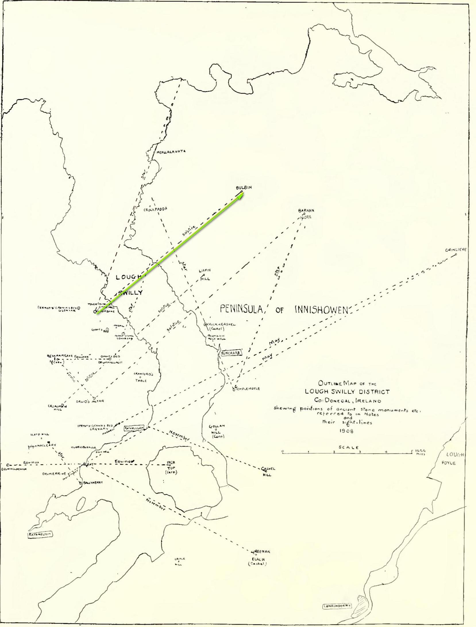
Intriguingly, one of the archaeo-astronony pioneers, Boyle Somerville (1909) wrote a article in the Journal of the Royal Society of Antiquaries of Ireland about a number of summer solstice alignments he thought existed in this precise locale. Amongst them was one he found running from the standing stone at Cloghbane on the other side of Loch Swilly—known as the White or Rowan Stone—heading northeast to the small mountainous peak of Bulbin, approximately 7.1 mile away. Somerville found that,
“The outline of the mountains visible to the northward from Cloghbane shows two sight-lines that undoubtedly were used from this position. One is for the summer solstitial sunrise over the prominent peak Bulbin; the other is over a low and small but conspicuous round-topped headland, towards the mouth of the Lough, which is in line with an exactly similar hill behind it; their two summits being practically coincident, forming a single sky-line; so that, from Cloghbane, their angle of elevation by theodolite is the same.”
The primary motifs
The first alignment is the relevant one here: it not only relates to the rising sun at solstice in 1000 BC, but our Glebe petroglyph lies right on the edge this alignment! (give or take a few yards) Whether or not this is a coincidence we cannot say for certain, but the ‘solar motif’ in the design would seem a strong indicator that implies some sort of solar function here.
As always with cup-and-rings, their non-linear designs tickle our minds with possibilities, probabilities and that there thing called the mysterious, which Einstein described as “the source of all true art and science…”
One final and important thing to anyone who may want to visit this site: please contact the farmer and ask his permission if you want to see it. Cheers. 😉
Acknowledgements: Massive, huge huge thanks to Bettina ‘Grianan Swilly’ Linke for the superb photos and data for this site profile. And (although he doesn’t know it yet!) thanks are also due to the farmer and his employee who rediscovered the carving and to Liam McLaughlin who put pen to paper and told the rest of us about it.
Follow the same directions as if you’re visiting the impressive Fairy Stone carving, then 3 yards east is the Cottingley 2 double cup-and-ring, keep walking past through trees for another 5-6 yards where you’ll come across this reasonably large curved flat stone. Y’ can’t really miss it
Archaeology & History
Cup, with ring faintly visible
This was another carving in the small cluster by the Fairy Stone that I found on my visit here in the 1980s—but it’s a pretty innocuous one to be honest. There’s a faded incomplete “ring” (not really visible on my photos due to pouring rain and very poor light when I was here) with a distinct cup-mark in the middle. Several inches away from the cup-and-ring is a carved line that arcs around it creating an incomplete oval design; and what seems to be a single cup-mark is visible at the top of this oval. Other marks on the stone are both natural as well as recent ‘scratches’.
Some elements of this carving—as with others in this petroglyph cluster—seems to be modern. The cup-and-ring seems to be the real deal, but the ‘oval’ seems to have been added much more recently, perhaps by the scouts who play around in this part of the woods.
A couple of miles east of Crieff, take the A822 road from the Gilmerton junction towards the Sma’ Glen. After literally 1¾ miles (2.8km)—just 100 yards before the track up to Connachan Farm—you’ll reach a dirt-track on your left that leads into the hills. Go along here for 250 yards (230m) yards (the track has straightened out here) and then walk into the reeds on your right. About 15 yards in, look around!
Archaeology & History
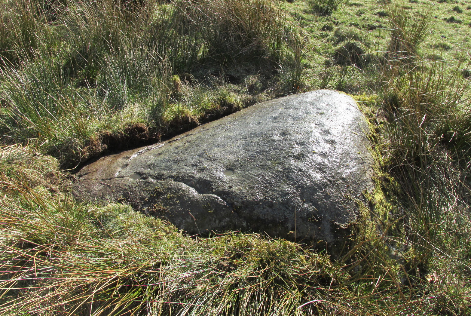
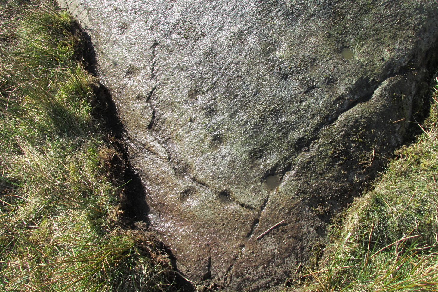
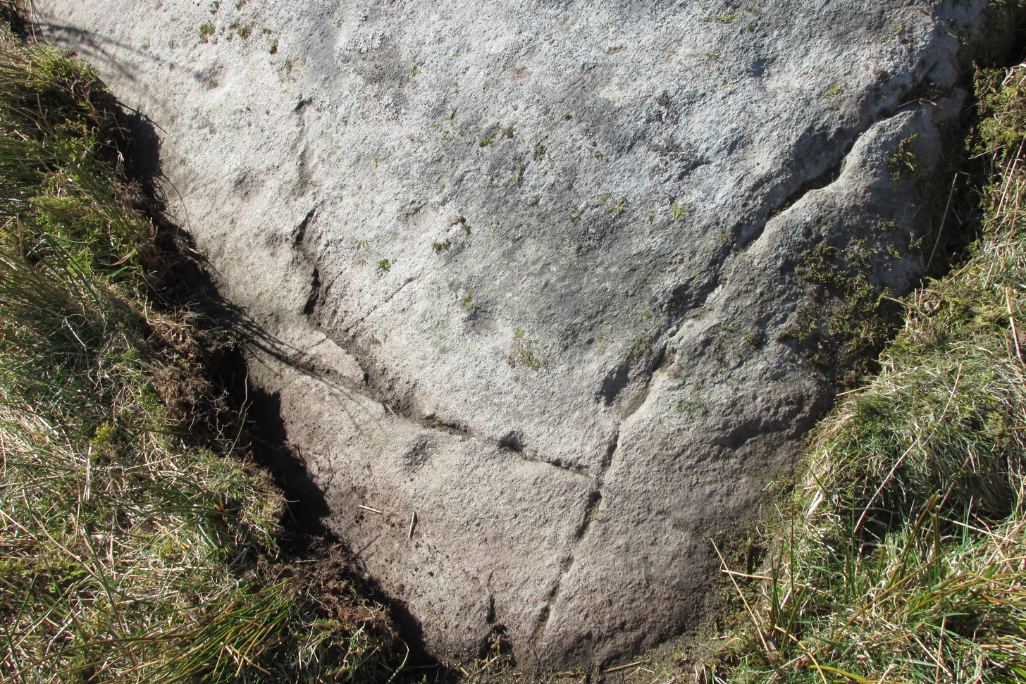
Another one of those fascinating carvings that had me here for an hour, maybe more, poring over more and more features as the light, shadow and rock gave more and more depending on how I looked at it. Tis the same with many petroglyphs, of course… But I liked this one.
On initial impression it didn’t seem up to much: maybe a few faint cups—some certain, others no so much. But the more attention we gave this stone, so more of those unlikely faint cups became much more real. At first there were a dozen; then 15 or more; but as we gave it more and more attention, so more of the petroglyphic design showed its original form. They do that, these stones! When George Currie rediscovered this carving in 2008 he found 17 cup-marks on the stone, but at least thirty of them go to make up this petroglyph. There may even be a very faint, albeit incomplete ring around one of them, but I’ll let the computer-tech kids work that one out!
Natural cracks with cups & carved extensionsNatural cracks with cups & carved extensions
This carving has that peculiar and not-too-infrequent element of having some cups carved into the natural cracks in the stone. In this case, at least four of them can be seen etched into the large deep crack that runs along its more northern edge. They’re quite distinct once you get your focus on them. In this case—albeit it to a much lesser extent—this feature reminded me of the impressive West Strathan carving in Sutherland. But where this natural crack finishes, it has been artificially extended until it reaches the eastern edge of the stone. You’ll also notice in the photos highlighting this feature, that another artificial line has been carved at right-angles to it, heading south, until it meets another natural crack in the stone. It’s quite distinct. And along this second artificial line, you’ll notice another cup or three—one of which has been cut into the line. These two man-made extended cracks in the stone, give the simple impression of an early cross symbol. Features such as this, whilst seemingly trivial to the bog standard explorer, possess some very curious myths in some living traditions elsewhere in the world; but such things are beyond the remit of this site profile.
References:
Currie, G., “Falls of Monzie, Perth and Kinross (Crieff parish), Cup-marked rock”, in Discovery & Excavation Scotland (New Series) volume 9, 2008.