Bàrr a’ Chuirn, Kilmartin, Argyll

Cairn:  OS Grid References – NR 8122 9782

Also Known as:

  1. Canmore ID 39465
  2. Lady’s Seat Cairn

Getting Here

Many ways to get here, but you’ve gotta amble off-path through the woods to eventually find it — but it’s not difficult. From Kilmartin village head to Slockavullin and walk up the winding track which takes you towards the Ballygowan cup-and-ring stones, but follow it into the woods instead. The OS-map’s gonna be your best guide here. I first visited this spot from the south and ambled about, aimlessly at times for several hours, after I’d first been to the great ruined mansion of Poltalloch. Well worth checking out if you enjoy finding allsorts!

Archaeology & History

The old tomb is actually a few hundred yards beneath the small rocky summit of Barr a’ Chuirn, with the overgrowth of the woods imposing itself upon it. The Scottish Royal Commission report (1988) told that there was a large seat built here in the 19th century called the Lady’s Seat, and actually set up on the cairn itself so giving groovy views all round to those who came here. The Seat was made from large slabs of stone, which may originally have come from the old tomb.  An excavation here in the mid-19th century,

“found the remains of two cists and some burnt bones, with a ‘skeleton of later date, between the two cists, but probably put there by the men who destroyed the cairn.’ In 1929 Craw re-examined the site and found that the central cist had chambered and grooved slabs. This cist is aligned ENE and WSW, and the E end-slab is now missing; the cist measured about 1m by 0.5m and about 0.3m in depth internally. The northern side-slab is grooved at the west end.”

References:

  1. Royal Commission on the Ancient & Historical Monuments of Scotland, Argyll: volume 6 – Mid-Argyll and Cowal, HMSO: Edinburgh 1988.

© Paul Bennett, The Northern Antiquarian

Cultoon, Portnahaven, Islay, Argyll

Stone Circle:  OS Grid Reference – NR 1956 5697

Also Known as:

  1. Cultoun

Archaeology & History

Following excavation work on this denuded megalithic ring in 1974 and 1975 under the joint auspices of the Islay Historical Works Group (IHWG) and the Hunterian Museum of the University of Glasgow, under the direction of archaeologist Dr Euan MacKie (1976), with the intent of actually restoring the site to what they thought was its former glory by resurrecting the fallen monoliths in this ring of stones, some intriguing facts came to light.  Dr MacKie wrote:

“This site stands on a low, shallow knoll about a mile from the sea and with an extensive peat bog to the west.  Before excavation the stone ring consisted of a rough oval of two standing stones and ten fallen ones, the latter being partly or nearly completely buried under the turf.  The dimensions of the ring were about 45 by 40 yards.  The excavations were based on a 6m grid and the ain was to explore as much as possible the perimeter of the ring and part of the interior.  In this way it was hoped to identify the sockets from which the prone monoliths were assumed to have fallen and thus to discover the exact positions at which they were to be re-erected…

“It soon became clear that the prone monoliths had not in fact fallen out of their sockets.  All of them lay on the old ground surface under the peat which had evidently begun to grow — in the 8th century BC according to one C-14 date — after the site had reached its present condition.  Some stones had no socket next to them and a number of sockets were found without adjacent stones.  Several stones lay next to sockets in such a position as to make it clear that they had never been set up.  The site had evidently been abandoned in the middle of construction and those sockets already dug were allowed to fill slowly with rubble and silt.  One socket was discovered which had been deliberately filled up, confirming that some change of plan had occurred before the final abandonment.  Cultoon is the only stone circle apart from two phases of Stonehenge to have revealed evidence of never having been completed. (my italics, Megalithix)

“The finds were few and consisted of mesolithic flint microliths and some larger, presumably neolithic flints.  The former were all on and in the buried topsoil — the circle builders’ ground surface — while the latter were on the land surface and in the lower part of the peat; these last included scrapers and are hollow-based points of Bronze Age type.  Of particular interest was the discovery of caches of flint flakes in the peat next to the two standing stones.  They appear to be deliberate offerings and suggest that the site retained its sanctity for some centuries after its abandonment.”

…to be continued…

References:

  1. MacKie, Euan, “Cultoon, Islay,” in Glasgow Archaeological Society Bulletin, No.2, 1976.

© Paul Bennett, The Northern Antiquarian

Tobar Mor, Tarbert, Gigha, Argyll

Sacred Well:  OS Grid Reference – NR 6564 5190

Also Known as:

  1. Canmore ID 38609
  2. Great Well of the Winds
  3. St Beathag’s Well
  4. Tobar Bheathaig

Folklore

There are a number of sacred and healing wells on this small island, but this site in particular was deemed magickal by folk from far and wide.  Found on the northwest slopes of Cnoc Largie (around which are other heathen spots) this legendary site had an attendant keeper of the well:

“an aged female direach, or guardian, whose uncanny powers could be commanded by a small offering of silver.  Following this the cover of the sacred well would be removed in order that its waters might be ceremonially cleansed with a white clamshell prior to being stirred three times, sunwise, to the accompaniment of ritual incantations.  Then three shell-fulls of the sacred water would be hurled aloft in the direction of the desired wind which, before the day was out, invariably appeared.”

This simple ritual obviously tells that it was a heathen site, seemingly one for divination and magick.  Another piece of folklore (found at other wells) told that if the cover on the well were left unattended, its waters could overflow and flood the entire island.

References:

  1. Anonymous, Exploring Historic Kintyre and the Isle of Gigha, Harlequin Press: Oban n.d.

© Paul Bennett, The Northern Antiquarian
The Bodach and Cailleach, Gigha, Argyll

Sacred Stones:  OS Grid Reference – NR 6382 4730

Folklore

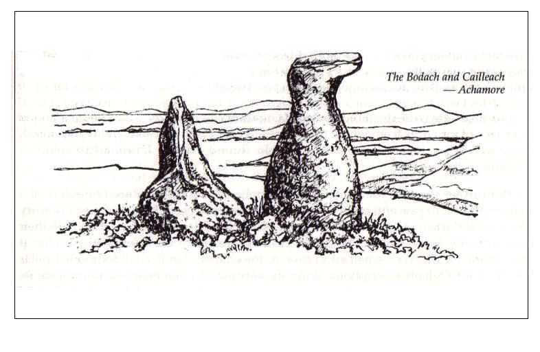
The Bodach and the Cailleach
The Bodach & the Cailleach

On this “Isle of the Gods” — as some historians proclaim Gigha to mean — the ancient rites and ceremonies of local folk continued until pretty recent times.  One writer narrated some intriguing pre-christian events connected to this curious and little-known place, speaking of indigenous heathen rites:

“These are in fact known to have persisted on the island until well into the early part of the (19th) century when Irish fishermen could still be seen climbing the little hill of Moinean Sitheil, in the sacred Moss of Peace below Ardminish, to pay homage to the “Old Ones” of Gigha: a pair of ancient legend-shrouded stones known as the Bodach and the Cailleach, that from time immemorial have stood upon a low green knoll below the farm of Achamore.

“Through the countless ages the strange jug-headed little Bodach and his smaller consort have kept steadfast vigil over Gigha: their mysterious aura said to guarantee its continuing fertility and prosperity as they link the thriving island of today with beliefs and traditions having roots in the earth-cults and sun-worship of primeval times.  In the past folk would have honoured them with offerings of meal or milk and even now they still command considerable local affectation and respect, albeit expressed in less overtly pagan ways.  And so they stand as ever upon their tiny hillock gazing out across tumbling terraces of old Cantereoch and beautiful Ardlamey Bay, inscrutable and silent, yet with a strangely ‘knowing’ air impossible to define.”

References:

  1. Anonymous, Exploring Historic Kintyre and the Isle of Gigha, Harlequin Press: Oban n.d.

© Paul Bennett, The Northern Antiquarian

Ardfernal, Jura, Argyll

Standing Stone:  OS Grid Reference – NR 56009 71718

Also Known as:

  1. Canmore ID 38262

Getting Here

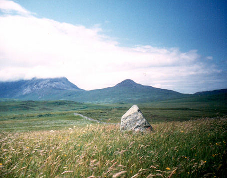
Go up Jura’s only road until it becomes a dirt-track and head along the track to the east to the natural hillock on the coast.  You’ll pass the three standing stones of Knockrome before you get to this one, right by the end house.

Archaeology & History

Found in a beautiful setting, this is a thick little stone but is less than four feet tall and it may have had some shapely relationship with one of the hills (Corra Bheinn) on Jura.  The Royal Commission (1984) described it merely as, “an erratic boulder measuring 3.1m in girth at the base, and 1.2m in height with its longer axis aligned roughly east and west.”  Several other stones can be found nearby.

References:

  1. Royal Commission on the Ancient & Historical Monuments of Scotland, Argyll – volume 5: Islay, Jura, Colonsay and Oronsay, HMSO: Edinburgh 1984.

© Paul Bennett, The Northern Antiquarian

Dun Chathach, Connel, Argyll

Hillfort: OS Grid Reference – NM 9674 3401

Also known as:

  1. Canmore ID 23261
  2. Dun Cathich

Getting Here

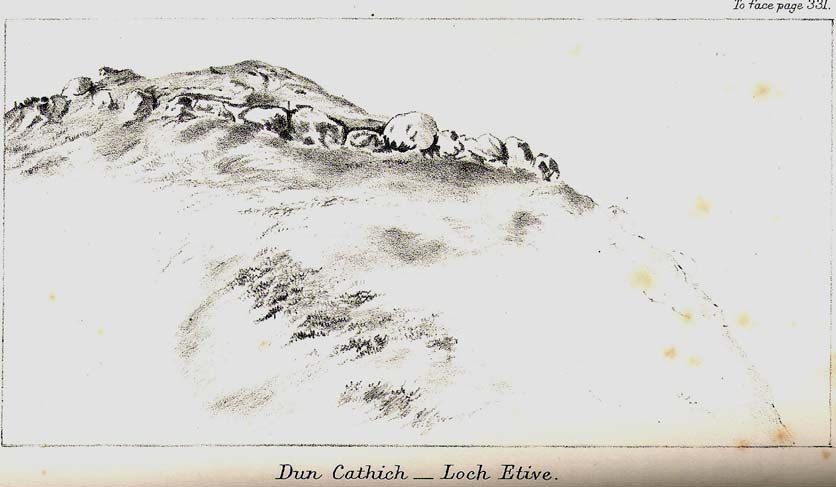
Dun Chathach (drawn by Miss J. Knox Smith 1885)

Go up from Oban on the A85, past Connel and towards Taynuilt, keeping your eye out for where the train-line crosses the road. Just before this is a small road on your left leading down to the sea, with the train line running parallel all the way down. Go right to the end and then look up to the rocky rise a coupla hundred yards on where the train line runs out of view round the coastal edge. That’s it!

Archaeology & History

When Scottish writer and historian R. Angus Smith (1885) first saw this, the close arrangement and size of the stones that make up the edges of this dun made him think this was actually a stone circle up here.  Sadly it wasn’t to be.  Following an examination of the site in 1969 by members of the Scottish Royal Commission (Argyll – Volume 2, 1975), they described Dun Chathach as,

“circular in plan…measuring 18.3 metres in diameter externally. The wall, which has been about 3.4 metres in average thickness, is now reduced to a low grass-grown stony bank, but considerable stretches of the outer face are still visible in situ. Many of the facing stones, which lie as much as 1.6 metres below the level of the summit, are of massive proportions, the largest measuring 1.4 metres by 1.3 metres and 1 metre high. It is uncertain which of the three gaps now visible in the wall indicates the site of the original entrance.”

Folklore

Legend has it that this was a hill of battles.  It was also said by R. Angus Smith (1885) to “have been used as one of a chain of beacons,” with the next fire on being lit upon a small hill nearer Connel called Tom na h-aire, ‘the mound of watching.’

References:

  1. Royal Commission on the Ancient & Historical Monuments, Scotland, Argyll- volume 2, HMSO: 1974.
  2. Smith, R. Angus, Loch Etive and the Sons of Uisnach, Alexander Gardner: London & Paisley 1885.

© Paul Bennett, The Northern Antiquarian
The Bastard, Campbeltown, Argyll

Hillfort / Dun:  OS Grid Reference – NR 7612 1220

Also Known as:

  1. Canmore ID 38722
  2. Dun Bastard

Getting Here

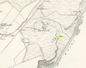
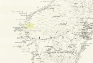
The Bastard on 1869 map

Pretty easy.  From Campbeltown, follow the coastal round south for about 8 miles, past the TV masts on the skyline and the hamlet of Feochaig, where you’ll see the large rounded hill on your left near the coast: that’s The Bastard!  Go onto the hill’s eastern sides and drop down the steep slope towards the large bend in the burn where its remains are on a ridge close to the cliffs overlooking the sea.  The ruins are pretty faint but if you scout around, you’ll find it.

Archaeology & History

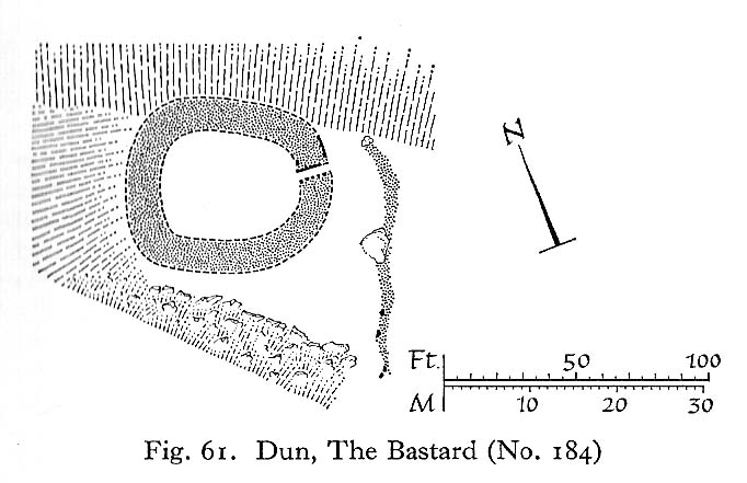
I couldn’t believe it when I found this one – so had to get the notes to the site and add what I could find!  When the fellas from the Scottish Royal Commission checked the place in 1960, they described,

“On a narrow shelf halfway down the east flank of the hill named The Bastard there are the remains of a dun…  Oval in plan, the dun measures about 15m by 12m internally and is entered from the east, where a stretch of the outer face is visible. Here the wall is 4m thick on either side of a straight passageway, 0.9m wide, which exhibits no trace of door-checks.”

The Bastard (RCAHMS 1971)

There are other remains a few yards to the southeast of the main structure which are thought to be “remains of an outer wall…about 1.2m in thickness, which has been drawn across the shelf to provide additional protection for the entrance”, more probably from the weather conditions than invasive incoming humans.

To the immediate north we have a mythic-sounding Giant’s Seat (just above the natural arch) and west is the abode of the fairy folk – but I aint checked out the tales behind them yet.

References:

  1. Royal Commission Ancient & Historic Monuments, Scotland, Argyll – Volume 1: Kintyre, HMSO 1971.

© Paul Bennett, The Northern Antiquarian


Dun Bhuirg, Iona, Argyll

Hillfort:  OS Grid Reference – NM 2649 2462

Also known as:

  1. Canmore ID 21638
  2. Dun Cul Bhuirg

Getting Here

Take the road that cuts across the island, west, until you reach the stupid golf-course.  Walk across it, heading for the coast (not the building at Culbuirg), then follow the little footpath up until you reach the large rocky rise about 500 hundred yards north.  That’s it!

Folklore

Dun Bhuirg on 1881 map

Shown on the 1881 OS map of the region, the small remains of this Iron Age hillfort was said to be the place where St. Columba saw a rain-cloud which he predicted would bring a plague of ulcers to the people of Ireland. To prevent such a plague, Columba thence dispatched a monk called Silnan to Ireland, armed with some bread which he’d blessed. This bread was then dipped in consecrated water and given to those afflicted with the plague, who were thereafter cured.

Wee-ird……

Another tradition told that this old fort was once an important meeting place for the druids, though Geoff Holder (2007) writes that this is little more than a “spurious nineteenth century tradition” which he dismisses as without foundation. Though a short distance from here, he also told how one “Fiona MacLeod” (real name, William Sharp) one night watched the ghost of the Culdee, Oran, a couple of hundred yards away, “and so he never went that way again at night.”  In truth, traditions of druidism tend to be animistic traits: legends remembered from pre-christian days, and blanket dismissals of such folklore are themselves untrustworthy—especially on this Isle of the Druids.

References:

  1. Holder, Geoff,The Guide to Mysterious Iona and Staffa, Tempus: Stroud 2007.
  2. MacLeod, Fiona, Iona, Floris: Edinburgh 1982.

© Paul Bennett, The Northern Antiquarian


Dun Dubh, Ford, Argyll

Dun:  OS Grid Reference – NM 8640 0479

Also Known as:

  1. Canmore ID 22821

Getting Here

From Ford village, take the track that goes uphill (west) running near the edge of the forest-line. Keep going until you hit the top of the forest and the large rocky hill above you (on your right) is where you need to be heading.  The rise to your left is Dun Chonallaich.  Walk around the bottom of the hill until you get to the other side (you should be 100 yards or more above the tree-line) where you’ll notice a ‘pass’ running west, with a rocky knoll above you on your right.  That’s it!

Archaeology & History

Thought to date from the Iron Age, the remains here cover an area 15 yards by about 25 yards.  Remains of walling around the edge of the summit nearly a yard wide in places define quite clearly where the ‘fort’ was centred.  The entrance to the site was found on the northwestern side.  In more recent times however, animal pens have intruded on the remains here and the archaeological remnants are much denuded.

Folklore

Samhain fires were lit on the larger ridge above this ruined fort until recent years, as some old local folk will tell you. These Halloween fires (done to celebrate the old New Year) were stopped a short time after the new ‘owner’ of the Auchinellan Estate (on whose land Dun Dubh is found) took exception to them and, for all intent and purpose, deemed them a fire hazard! The lady in question who inherited the Estate was in fact a devout christian who took exception to the local “pagan” goings-on, contrary to the beliefs of the previous Estate owner, who not only allowed such old events, but played a part in them.  Local folk hereabouts, not surprisingly, aint too keen on their part-time dictatorial christian neighbour.

The fires up here were also related to the linear cemetery at Kilmartin. Here the giant tombs all line up & point to Dun Chonallaich, behind which hides the more flattened top of Dun Dubh. When the Halloween fires were lit on top of this, the glow from behind the great pyramid of Chonallaich all the way down to Valley of the Kings, was spectacular! One wonders just how long the local people had been doing this…

References:

  1. Royal Commission on the Ancient & Historical Monuments, Scotland, Argyll – volume 6, HMSO: Edinburgh 1988.

© Paul Bennett, The Northern Antiquarian


Tobar na H-aoise, Iona, Argyll

Holy Well: OS Grid Reference – NM 2839 2525

Also Known as:

  1. Canmore ID 21613
  2. Pool of Healing
  3. Well of Age
  4. Well of Healing

Folklore

Although ascribed as a holy or healing well, this site is actually a curious natural water-filled depression near the top of Dun I, on the northern side of the island.  It is one of three magickal wells to be found hereby.  F.M. McNeill (1954) described this Well of Eternal Youth as having a fame that had spread far and wide, saying,

“Here, through ages past, pilgrims of each generation have lingered at the enchanted hour of dawn, ‘to touch the healing water the moment the first sun-ray quickens it.'”

In doing so, devotees would recover the energies of youth once more and live a longer healthy life.

References:

  1. Hannan, Thomas, Iona and some Satellites, W. & R. Chambers: London 1928.
  2. McNeill, F. Marion, Iona, Blackie & Sons: Glasgow 1954.

© Paul Bennett, The Northern Antiquarian