From Bingley, take the B6429 road up to Harden. After going up the wooded winding road for a few hundred yards, stop where it levels out. Cross onto the right-hand side of the road and walk up the slope a little, veering to your right. You’ll notice a small disused building just off the roadside, in overgrowth, with a pool of water. You need to be about 100 yards up the slope above it!
Archaeology & History
Elm Crag Well, Bell Bank Wood, Bingley
This is a beautiful old place. If you walk straight up to it from the roadside, past the derelict building, you have to struggle through the brambles and prickly slope like we did – but it’s worth it if you like your wells! However, if you try getting here in the summertime, expect to be attacked on all sides by the indigenous flora! The waters here emerge from a low dark cave, in which, a century of three ago, someone placed a large stone trough. When I first came here about 25 years ago, some halfwits had built an ugly red-brick wall into the cave which, thankfully, someone has had the sense to destroy and rip-out.
Shown on the 1852 Ordnance Survey map and highlighted as a ‘spring,’ Harry Speight (1898) gives a brief mention to this site, though refers us to an even earlier literary source when it was first mentioned. In John Richardson’s 18th century survey of the Craven area, he makes reference to an exceedingly rare fern, Trichomanes radicans, which was later included in Bolton’s classic monograph on British ferns of 1785. In it, Bolton wrote that the very first specimen of this plant was “first discovered by Dr. Richardson in a little dark cavern, under a dripping rock, below the spring of Elm Crag Well, in Bell Bank.”
Elm Crag Well
The waters from here come from two sides inside the small cave and no longer run into the lichen-encrusted trough, seemingly just dropping down to Earth and re-emerging halfway down the hillside. But the waters here taste absolutely gorgeous and are very refreshing indeed! And the old elms which gave this old well its name can still be seen, only just hanging on to the rocks above and to the side, with not much time left for the dear things.
References:
Bolton, James, Filices Britannicae: An History of the British Proper Ferns, Thomas Wright 1785.
Speight, Harry, Chronicles and Stories of Old Bingley, Elliott Stock: London 1898.
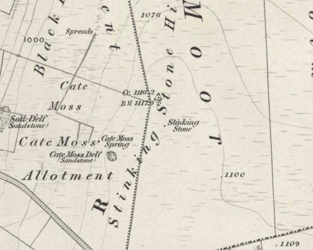
One of two ways to get here really. The easiest is from Sutton-in-Craven: go through the village and up the steep hill (don’t take the right turn as you start up the hill). Go all the way up until the hill starts to level out and on the left-side of the road you’ll notice a boundary stone stood upright (this is the Sutton Stoop). Stop here. Of the 2 gates, climb over the top-most one and walk down the path into the adjacent field, heading over to the gap a couple of hundred yards away where the gate to another field is. That’s it!
Archaeology & History
Stinking Stone, Steeton
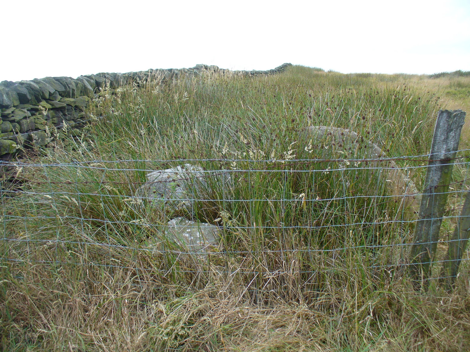
Now here’s a weird one. With a name like this you’d expect there to be plenty of info or historical comments. But despite all the books and journals in my huge library, aswell as visiting town libraries and exploring the resources on-line, there’s nowt written about this ‘ere spot. Not a jot! Even the usually satisfactory place-name fellas have a thing-or-two to say about sites with names such as this—but even their old tomes are closed-lipped. Hmmmmm…..
I visited the place several times to try ascertain what this site was, thinking — perhaps — that it was an old boundary stone whose name had been convoluted from some older, more obvious title.* The nearby Sutton Stoop boundary stone, right by the roadside, seemed a good indicator to such an assumption, as it was a recognised boundary marker with written history and a meeting point along the local perambulation. But the curiously-named Stinking Stone was neither on the same line, nor ever had been according to old records, and couldn’t be located either. There had been obvious quarrying and other industrial destruction along the hilltop where the old stone was marked and it seemed logical to assume that it had been destroyed in bygone years by that usual breed of capitalist industrial halfwits. Until a psilocybin venture one afternoon, last season…
Twas a lovely sunny day, though windy on the tops as usual. I was out with a couple of neophytes showing them Psilocybes and various other species, chewing them here and there and talking the way of healthy usage. We passed by an old well, long forgotten, before heading onto Stinking Stone Hill. Bimbling somewhat, and ruminating about the moss of colour, we decided to sit by the walling in-field and dream for a short while. As we hit the old gate the Stinking Stone came up right before us. Literally!
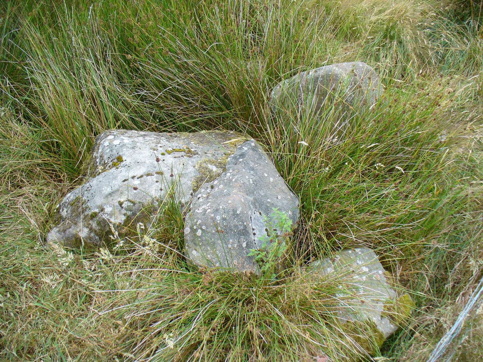
There in the old walling, blunt as you like, stood this four-and-a-half-foot tall standing stone, smoothed on one side by a short aeon of weathering, upright and proud as if it had been stood there for centuries, awaiting attention! I exclaimed a few triumphant expletives; rubbed myself here and there over the old thing, then sat for a while behind the wind with the old upright, solidly embedded in old earth — then awaited the dream…
Twas a good day…
And then I returned home and later sought what I could on a possible etymology. Around the hilltop a hundred yards away were small depressions and the faded remains of industrial workings, like I said; and with this in mind the awesome Mr Wright (1905) told us about the existence of ‘Stinking coals’, “an inferior kind of coal” no less. Referring us to a work from 1818, we’re told,
“The Stinking-coal is noted for containing a great proportion of sulphuret of iron, thick seams or layers of these pyrites running in it. In consequence of this it cannot be used for smelting purposes.”
Another account from 1868 telling us that:
“On opening the body, it contains a strong sulphureous smell, characteristic of the disease; hence it is called the stinking ill; and the stomach and bowels are prodigiously distended with air, having the same intolerable foetor.”
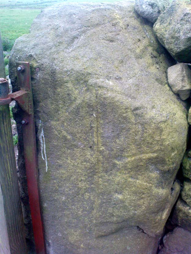
Worn metal scratches, made when dragged here?
This old worn gatepost however, perhaps has a history that only goes back a few centuries. It has been cleaved in half, as you’ll see if you visit it; but its western face is old and worn and it’s been embedded in the ground for a long time. On its northern face are the curious etchings of carvings, which are more akin to wounds from some past offence (perhaps when it was split in half), cleaved by metal toolings and dragged by farmers to be fixed in into present spot. It’s history may not be truly ancient. Twouldst be good to know for sure though…
References:
Wright, Joseph, The English Dialect Dictionary – volume 5, Henry Frowde: Oxford 1905.
* ‘Stinking’, stone-king or King Stone? Unlikely though…
From Carlton, take the western Hirst Road to Temple Hirst village, then turn right once you’re in the village and go up Common Lane up for about a mile. There’s a footpath on your left leading you to the Fair Oaks farmhouse. This was the spot!
Archaeology & History
This is fascinating sounding place which marked the central point of three old township boundaries nearly 1000 years ago. I first found it mentioned in Morrell’s History and Antiquities of Selby (1867: 36-7), where this once famous tree is described in land sale transactions. Morrell told:
“At Carlton the (Selby) abbey had considerable property, which was sold to the neighbouring priory of Drax. The boundary of the property sold was a certain oak tree, called Fair-haia, in Burn Wood, which Adam de Bellaqua gave for this purpose, binding himself and his heirs never to cut it down or root it up, sub poena anathematis.”
But we found a more detailed outline in Dugdale’s Selby Abbey in Yorkshire, where the premises and townships given to Selby Abbey in the 12th and 13th centuries are listed. In the township of ‘Carleton’ (as it was then spelt) Dugdale wrote:
“Peter de Brus gave the grange here, which the monks had held of Agnes, late wife of Ranulph FitzSwain. Richard abbat of Selby granted to Robert prior of Drax all the tithe from the north part of the oak called Fair-haia, in the wood of Birne, or Berlay, through the middle of the marsh to Hundolfsweith; and from thence by the strait ditch directly to Espholm, and all the tithe from Espholme to Appletreholme, as the ditch goes to the new fosse or ditch of Carleton: and the prior granted to the abbat all the tithes on the south to the new ditch, and from thence to the river Ayre. And Adam de Bellaqua gave this oak tree, called Fair-haia, as a boundary, never to be cut down (ad standum in perpetuum et non rescindendum), binding himself and his successors never to cut it down or root it up.”
One wonders: are there any remains left of this once great tree? Has anyone actually transgressed and uprooted it in times past? Is any other lore known of it? And who was Adam de Bellaqua?
One of the most intriguing elements to this site is its name, for the word ‘haia’ literally means ‘god of the land’ — but whether we can take this meaning seriously is questionable, as it’s of Sumerian origin. However, no local dialect words throw any light on the word and it may aswell be the name of the spirit of the tree as anything else. Does anyone know owt more about this place?
Dead easy this one! Go along North Street in Keighley, towards the main church in the middle of town (a St. Andrew’s church, previously St. Pete), by the once-infamous Lord Rodney pub, and the old stone edifice stands outside by the Green. The much better Red Pig public house is across the road from here.
Archaeology & History
Keighley’s Town Cross, 1847 – on a painting by Edwin Riby
For a relatively trivial archaeological site, it’s got a bittova history. Not that this is an old site either! We’re not sure just when this cross was made, but it’s certainly no more than 300 years old. Before standing in its present position outside St. Andrew’s Church, sometime before 1840 it was said to have been a few hundred yards away above the present roundabout on Oakworth Road; and one record tells that it originally came from nearby Utley, a mile to the north. Due to lack of decent records, we’re not sure about its early status as a market cross, nor when it was first erected. Indeed, even the steps on which the cross presently stands are clearly more recent than the ones illustrated on Edwin Riby’s 1847 portrait, reproduced here.
Keighley Cross, on a grey wet day!
It would be good to get a complete history of this archaeological relic but it’s difficult with artifacts such as these; and although gaining access to the church now takes less time and effort than it used to (the vicar here used to be quite unhelpful, but has recently changed his ways – which is good!), it’s only open at certain times of the week.* Friday afternoons seem OK to have a look round. Please – if folk begin having trouble gaining access to the Church once more, let us know on here so we can make complaints about it. The Church is paid for by local tax-payer’s cash, and so needs to be open to all of us. Let’s hope this humble ingredient can be maintained for the good of all in this otherwise regressive social community (Keighley, that is…).
There’s also some very curious folklore to be added here in relation to the market and its cross, but its tale is gonna have to wait…
References:
Gray, Johnnie, Through Airedale, from Goole to Malham, Elliott Stock: London 1891.
Keighley, William, Keighley, Past and Present, R. Aked: Keighley 1858.
* There isn’t even a notice giving information, email or phone numbers, telling you who you can contact if you want to know anything about the history of the church, or visit it — which is quite dreadful considering how much money they get paid by tax-payers for their supposed socio-spiritual duties.
Go to the Cliffe Castle Museum on the outskirts of Keighley town centre (dead easy to find with car park to rear) and explore the museum! You’ll find it eventually!
Archaeology & History
Comet Stone, Cliffe Castle Museum, Keighley
This lovely-looking carving has been on a bit of walkabout over the last hundred years or so! We’re not quite sure exactly where it first lived, but old records tell that it was found upon the Grubstones Ridge, which is a small section of the moor around and/or between the Great Skirtful of Stones giant cairn and the curious Roms Law, or Grubstones Circle, both on the very tops of Burley Moor (most folk call think of it as just another section of Ilkley Moor). Here it lived (approx grid reference SE 138 446) for several thousand years until, many centuries later, in the mid-19th century, one of them there christian chaps came along – y’ know the sorts. He was the reverend J.A. Busfield and came to live upon the heathen edge of our Rombald’s Moor at a great house called Upwood. Like many of these weird people, he took a bit of a shine to our ancient relics and, amidst one of his sojourns to the Grubstones one day, came upon this multiple-ringed stone lying amidst the heather, close to the old circle of Roms Law. Liking it so much, he thought he’d have it as an ornament in the grounds of his hall at Upwood, on the southern edges of the moor overlooking Riddlesden and Keighley — and there it stayed, living quite comfortably, until 1925.
It then spent nearly fifty years living enclosed in the huge abode of Keighley Museum until, in 1971, it was presented by a certain Mr. R.W. Robinson of the same establishment, to Keighley Council, who thought in their weird ways to lean “it against a pile of rocks on the pavement of Bow Street, near Keighley Bus Station, with a small plaque,” telling of its tale and of other cup-and-rings nearby. And there it stayed until more recent years, when it was returned back to the Cliffe Castle Museum – safe, quiet and looked after each night!
Drawing of the carvingCowling’s early drawing
It’s a lovely, almost archetypal carving: a simple cup surrounded by four complete rings, with a ‘tail’ coming off the edge, similar to the image of a comet flying through the skies – which is, perhaps, what this carving represented. Of course, it could have been something completely different!
The region where this stone was located was an important area for the dead in ancient times – a motif that’s common to many cup-and-rings – and it seems probable that the stone itself was once part of a tomb, though we seem to have no record substantiating this. The carving was highlighted by William Cudworth as being in Upwood on a map dated 1847-51. The next description of it was by Arthur Raistrick in 1936. John Hedges (1986) listed it as stone-216 in his survey; then Boughey & Vickerman (2003) re-list it as stone 351.
NOTE – Don’t confuse this carving with another that is held in the same museum here, the Cliffe Castle or Baildon Moor 144 carving. Well worth having a look at!
References:
Boughey, Keith & Vickerman, E.A., Prehistoric Rock Art of the West Riding, WYAS: Leeds 2003.
Cowling, Eric T., Rombald’s Way, Otley 1946.
Hedges, John, The Carved Rocks on Rombald’s Moor, WYMCC: Wakefield 1986.
Raistrick, Arthur, ‘Cup-and-Ring Marked Rocks of West Yorkshire,’ in YAJ, 1936.
Healing Well (destroyed): OS Grid Reference – SE 0479 4179
Archaeology & History
The Whin Knoll Well, once found bursting into life at the top of Black Hill, Keighley, got its name from the old word ‘whin,’ or gorse bushes (Ulex Europaeus)—also known in Yorkshire as the ‘Spindly Killer Bush’: a most apt title! These great spindly killer shrubs once profused where the waters of this old well used to bubble into view – indeed, there are still quite a few great old spindlies still scattered here and there!
The site was shown on old maps as being just two fields east of the more renowned Jennet’s Well, but this old public water supply that once fed the local people, was covered by a reservoir many moons ago. However, a wander up here recently found the reservoir empty, but a water supply was still bubbling out of the ground into the great concrete hollow. The last remnants of the Whin Knoll Well perhaps…?
Pretty easy really. From the town centre, head up the B6143 Oakworth Road for barely 100 yards then turn right up the long steep West Lane. Just keep going. Near the very top turn sharp right onto Shann Lane. And there, on the left-hand side of the road, right next to the solitary old-looking house just 100 yards along, is our little well! (if you end up with fields either side of you, breaking into hills, you’ve gone too far)
Archaeology & History
Jennet’s Well, Black Hill, Keighley (middle of the picture, next to house)
The history of this site is very scant. It was written about by local historian William Keighley (1858) as a holy well dedicated to an obscure saint, St. Jennet, although early place-name evidences don’t tell as much. Some have even suggested that the same ‘Jennet’ was the tutelary saint of Keighley and district itself. Local historian Ian Dewhirst (1974), writing about the town’s local water supply, thought that “water from a spring ‘a mile to the west’ above the town…was conveyed by stone troughs through the chief street for the convenience of house-holders,” was probably Jennet’s Well.
Folklore
Described by Will Keighley (1858) as having “great healing abilities,” its specifics were undefined. And when the great Yorkshire writer Harry Speight (1898) came here forty years later, he told of the site “having a great repute, though no one seems to know why.” Mr Keighley was of the opinion that Jennet’s Well may have been the christianized site which overcame the local people’s earlier preference of dedication at the True Well, more than a mile west of here, between the gorgeous hamlets of Newsholme and Goose Eye; but this would seem unlikely, if only by distance alone.
The name ‘Jennet’ itself initially seemed somewhat obscure. It is not recognised by the Catholic Church as a patron saint. The word could be a corruption of the personal name Jenny, perhaps being the name of a lady who once lived hereby. There’s also the possibility that the title may infer the well’s dedication to the bird – a not uncommon practice. And we also have the modern folklorists who could ascribe it to the fairy-folk, as Jennet and Jenny are common fairy names, and old wells have much lore linking the two. But as Michala Potts pointed out, bringing us back to Earth once again, a ‘jennet’ is an old dialect word for a mule. I rushed for my Yorkshire dialect works and, just as Mikki said, the old writer John Wilkinson (1924) told simply, ‘Jennet – a mule.’
References:
Dewhirst, Ian, A History of Keighley, Keighley Corporation 1974.
Keighley, William, Keighley, Past and Present, Arthur Hall: Keighley 1858.
Speight, Harry, Chronicles and Stories of Bingleyand District, Elliott Stock: London 1898.
Wilkinson, John H., Leeds Dialect Glossary and Lore, James Miles: Leeds 1924.
Cup-and-Ring Stone (lost): OS Grid Reference – SE 142 396
Archaeology & History
Listed in Boughey & Vickerman’s (2003) survey as ‘stone 186,’ I first came across a reference to this carving when I was young, in a short article by Sidney Jackson (1964) in his Cartwright Hall archaeology journal. A letter was sent to Mr Jackson in 1963 by a Mr Bernard Stubbs of Baildon, who wrote:
“This morning I visited Hope Farm, Baildon, where Mr Jim Bell, the farmer, told me of a cup-and-ring boulder which he had discovered while digging a hole to bury a sheep, in the polt of land at the rear of the farmhouse… He stated that the hole was covered with cup-and-ring markings. Unfortunately, the hole has been filled and concreted over.”
And no one has seen it since then! Damn! Recently we discovered a cup-marked stone carved on a now-upright stone in old walling in one of the fields immediately west of the farm, but it’s obviously a different one from that described in Mr Stubbs’ letter. There are several other carvings in this region that are not in the official records, but this particular ‘lost’ stone remains lost for the time being!
References:
Boughey, Keith & Vickerman, E.A., Prehistoric Rock Art of the West Riding, WYAS: Wakefield 2003.
Jackson, Sidney, ‘New Cup-and-Ring Boulder,’ in Cartwright Hall Archaeology Group Bulletin, 9:1, 1964.
Cup-and-Ring Stone (destroyed?): OS Grid Reference – SE 129 379
Archaeology & History
Over the years, many of us have looked for this site but without any success. If it hasn’t actually been destroyed, it could be in someone’s garden wall, probably without them even knowing about it. Indeed, even the grid reference given here is only an approximation (mine differs from the one cited by Boughey & Vickerman, who put the carving closer to SE 126 381) and the stone could have been a few hundred yards either side of here. The main description of it comes from a letter written by a Mr T.P. Noble in 1964, which was cited in Sidney Jackson’s article ‘Hirst Wood Cup-and-Ring Boulder,’ in Bradford’s Cartwright Hall archaeology journal, where Mr Noble wrote:
“Mr Cooper, who built these houses (Hirst Wood housing estate) about 1935, once told me that there was a perfect example of a cup-and-ring stone here, but later, when he came to search for it, he couldn’t find it. It appears it must have been removed and possibly broken-up when the foundations of the houses were excavated.”
Of course, as we don’t know the exact whereabouts of the carving, nor have we been left with an illustration of the stone, it’s difficult to say whether the description given by the great archaeologist Sir Mortimer Wheeler in 1958, is referring to the same carving. Wheeler told us that one day in his childhood when he was out walking with his father, R.M. Wheeler, they came across a seemingly unknown prehistoric carving, saying,
“On one memorable day in the woods beyond Saltaire, we found an unrecorded cup-marked stone (later, I believe, recorded by my father in a British Association Handbook)” – that work being the Handbook to Bradford and Neighbourhood (1900), edited by R.M. Wheeler.
Naathen…if there are any people from the Hirst Wood area reading this and who might know of an old carved rock stuck in some old garden walls nearby, let us know. You’ll be credited as the person who re-discovered this long lost carving – and we can get the story in the local newspaper.
References:
Boughey, Keith & Vickerman, E.A., Prehistoric Rock Art of the West Riding, WYAS: Wakefield 2003.
Jackson, Sidney, ‘Hirst Wood Cup-and-Ring Boulder,’ in the Cartwright Hall Archaeology Group Bulletin, 9:2, February 1964.
Stone Circle (destroyed): OS Grid Reference – SE 0898 4393
Also known as:
Bradup Bridge
Brass Castle
Kirkstones Circle
Archaeology & History
Lay-out of the site, c.1929 (after Raistrick)
Not far from the little-known site of Beacon Hill, this once important megalithic ring was described by Arthur Raistrick in 1929 as “the finest stone circle” in West Yorkshire. Sadly however, the complete destruction of the place in recent years has now left us with nothing to go by (you would think such actions were illegal, but we’ll come to that shortly).
The site measured thirty feet across and, until only a few years back, had a distinct embankment surrounding it. In 1885 Robert Collyer described 18 stones here; but in Raistrick’s (1929) survey only 12 were visible. He told:
“The circle is situated on the west side of the Keighley to Ilkley road, in the rough pasture called ‘Brass Castle’…immediately south and west of Bradup Bridge. The circle is approximately 30 feet diameter, but has been very damaged at some period since 1885. At that date 18 stones were standing, but now only 12 remain, though there are large unfilled holes on the sites from which the other stones have been removed. There are slight traces of a bank, but the most notable feature is the large size of the stones (millstone grit from the neighbouring escarpment) of which the circle has been made. There are some traces of a double circle, but it is not possible to be sure of this now. It seems certain that the stones were removed from this circle to repair the neighbouring Bradup Bridge, an act of vandalism always to be deplored… There is no appearance of this circle having been used for interment, nor any record extant of exploration.”
When Eric Cowling (1946) visited the site in the 1930s, his notes indicate that it was much as Raistrick had described a few years prior, telling:
“This circle is situated at the west side of the Keighley-Ilkley road near Bradup Bridge on the Airedale side of Rombalds Moor, near the crest. Only twelve stones remain standing; these are large and apparently obtained from the nearby escarpment (Kirkstones, PB); holes mark the site of stones removed. The ring is thirty feet in diameter with some traces of a circular bank; the position of some stones suggests that the circle may have been continuous. I have heard this place referred to as ‘Kirkstones’ and ‘Brass Castle’, both suggestive names.”
A newspaper account of the site in 1960 reported that 12 stones were still in situ and that “there are large holes from which the other stones have been removed.” This fact was echoed by a local walker, Ken Pickles, who knew the site well and said:
“I first walked this moor in 1945,” he says. “In the late 1960s there were definitely 12 there. It was a perfect stone circle. It offends me that children should be denied things like this.”
As if to affirm the status and number of stones again, when archaeologist Ian Longworth (1965) wrote about it he told that,
“Twelve stones remain in this badly damaged circle, which measures about 30 feet across. The stones are of local millstone grit. Several seem to have been removed from the site to repair Bradup Bridge.”
Sid Jackson’s old drawing
By 1995 only one stone was in situ, but a very distinct, albeit low circular embankment was still in evidence. I sat here quite a few times when I was young, munching mi sarnies, having a rest, alone and with friends (once in the company of holy wells author Edna Whelan and fellow rock art researcher and author Graeme Chappell) before journeying back home. It looked that at least one other stone was buried just beneath the grassy surface on the northeastern side of the banking.
Bradup is included in the respective archaeological magnum opuses of both Burl (2000) and Barnatt (1989); where the latter visited the site in the 1980s and thought it may have been “the last vestiges of a cairn.”
Arthur Raistrick’s (1929) plan shows that at least two stones stood near the centre of the circle, which may have related to a solstice sunrise alignment with the old standing stone at nearby Black Knoll hill on Morton Moor (replaced at an unknown date in the past by a stone cross). And when Mr Raistrick told this to be the best stone circle in the region, he knew what he talking about! He had surveyed many other prehistoric remains and was the leading archaeological authority in the region at the time. Today, we have no such professional authority in the region who is worthy of such an accolade. The sorry series of events that led to the destruction of Bradup’s stone circle took a little time to emerge, but after a series of emails to various departments several years ago, the culpability seemed to spread across several people, each of whom made simple mistakes; but these were mistakes that have led directly to Bradup’s demise. I hope some of you will forgive me telling its story…
Bradup stones removed & dumped near wallBradup stone remains dumped in a pile
I first received an email from a colleague in 2002 asking whether or not I was aware of what seemed to be the final destruction of the Bradup stone circle, as the land-owner from Upwood Farm had been over the field and uprooted some buried stones — plus the last visible upright in the ring — and moved them into a pile at the top southern-end of the field in which the circle previously stood. So a small bunch of us went over to have a look and, much to our horror, found the report to be true. The field itself had been completely levelled and the circular embankment flattened, with the upright stone and any buried ones dragged and dropped into the pile of stones that obviously constituted the megalithic structure we’d sat within and visited so many times down the years up against the wall at the top of the field. Someone — the land-owner it seemed — quite recently in early 2002, had destroyed the Bradup stone circle.
How the hell had this happened…!? So, I contacted those who were supposed to look after the welfare of such monuments.
In 2006, Pippa Pemberton was the person working for English Heritage who had the stately title of ‘Field Monument Warden for West Yorkshire’ and elsewhere — and it was Pippa who told the sorry tale, albeit through the well-disguised erudition of avoiding blame to anyone. Amongst several allegedly ‘professional’ archaeologists who I emailed, it was one to Neil Redfern that was responded to, eventually. As you’ll read below, my email asks how this stone circle had been destroyed, with the lengthy ‘explanation’ giving the official reasoning:
Bradup Stone Circle Destroyed
From: Paul Bennett Sent: 10 March 2006 14:05 To: REDFERN, Neil Subject: Stone circle destroyed nr Ilkley
Hello there!
I sent you an email quite a long time ago (below) concerning the complete destruction of Bradup stone circle on Ilkley Moor, for which I have heard nothing since. I wonder, out of respect, if you could either let me know the circumstances surrounding my query, or perhaps pass me on to the relevant person:
“Out of interest (and on the same moorland region) I wonder if you could let me know who it was from English Heritage who de-scheduled a site once known as the Bradup stone circle (also known as Kirk Stones) after a visit to the place a few years ago? (SE 0897 4393) The incorrect site/location was examined and the real stone circle, close by, was subsequently destroyed by the adjacent land-owner. Evidence of the destruction is still there at the top of the field in the form of a few oddly-piled small boulders.
“I think it important that whoever de-scheduled this site should be taken to task for their error. (I don’t mean sack the poor soul, although it’s evident that some re-training is probably in order.) or perhaps the land-owner taken to task for the destruction of the site.
“I would be interested to hear what you, or one of your fellow workers, think about what’s happened here.
Best wishes – Paul Bennett”
Sometime later, I received the following response:
“Dear Paul
Your email was passed on to me by Neil Redfern, as I am currently the person dealing with scheduled monuments in West Yorkshire. Please accept my apologies for the delay in responding to you – we have been working with Heritage Action on this issue, and it was accidentally assumed that you were associated with that organisation too.
In response to your query I have copied an extract from a recent letter I sent to Heritage Action about Bradup, outlining the history of the case and the justification for its descheduling. I hope that this text answers your concerns. For your information, should you require any further assistance with this case, I recommend that you return to me quickly as I am due to start maternity leave at Easter and we do not yet know who will be dealing with this casework in my absence.
With best wishes
Pippa Pemberton,
English Heritage Yorkshire Region, Field Monument Warden – West Yorkshire & Districts of Scarborough & Ryedale.
Scheduling and location of the Bradup site
Scheduled Monuments are currently provided statutory protection under the 1979 Ancient Monuments and Archaeological Areas Act, which replaced earlier legislation and is itself currently under review by the government (DCMS) in their Heritage Protection Review. Scheduled Monuments are a land-based designation, which means that they are fixed in space, with defined boundaries within which specific protection applies. The legally protected location of a Scheduled Monument is recorded on maps and described in associated documentation. Together these documents provide the legal record of the site and are the basis on which protection is applied.
Our records show that a site at Bradup was scheduled as a stone circle in 1933 at grid reference SE 0895 4391, based on information provided by a partial survey of the site made by Dr A Raistrick in 1920 and on reports recorded in 1885. This site was known by the name of Bradup Stone Circle. The location of this site is shown on the map attached to this email.
Subsequently the Ordnance Survey visited the site in 1961, when R Emsley undertook a measured survey of the locations of the stones and hollows included within the scheduled site. However he noted that the stones appeared, by that stage, to be haphazard in their distribution and he appears to have been unconvinced by the description of the site as a stone circle. On the basis of this visit by Emsley, the Bradup stone circle was marked on the 6” Ordnance Survey map, with the location given by Emsley as SE 0895 4392. In addition, Emsley noted that the unscheduled site known as ‘Kirkstones’ was located nearby at SE 0907 4479, but did not describe this site. We have no information on file about this site.
Visits were then made to the scheduled Bradup site by two Royal Commission / English Heritage Field Monument Wardens in 1981 and 1985, with the purpose of monitoring the management of the site. Both of these officers found the site difficult to distinguish, noting stones in a rough pasture field.
Subsequently, it appears that several other locations have been claimed for the Bradup Stone Circle across several fields in the locality, including SE 0897 4393 (Paul Bennett). This latter would place the circle within the adjacent improved pasture field and outside the previously scheduled area.
Descheduling the site
During 1994, a visit made to the site at SE 0895 4391 under the English Heritage Monuments Protection Programme (MPP) noted that the site described by Raistrick does not correspond with the remains then visible. According to this MPP officer, the spatial relationships between the stones and stone holes differed from those Raistrick recorded whilst he also appeared to have omitted others. In their opinion, the scheduled site was not a stone circle, but “a haphazard group of rocks … situated on a hillside which has been quarried and has naturally occurring gritstone boulders. The site itself consists of a random collection of boulders and small holes left by stone quarrying on a slight rise and has a roughly rectangular hollow in the centre which may be an excavation.” “The site is lacking in any of the other features normally associated with stone circles … Whether the extra stones represented by the stone holes are taken into account or not there are no grounds for considering this site to be a stone circle or any other type of prehistoric monument. It is therefore recommended for descheduling”.
Subsequently the recommendation for descheduling would have passed by the officer to the Monuments Protection team, who would have passed it to the relevant Inspector of Ancient Monuments for their consideration and approval. It would then have been passed to a committee of archaeological advisors for their consideration and approval before finally being submitted to the Department of Environment (now DCMS) for their approval and action.
Review visit to the descheduled Bradup site
In response to Heritage Action’s concerns, a site visit was undertaken to the descheduled site by several members of English Heritage’s Heritage Protection team in November 2005. At SE 0895 4391 they observed a number of exposed stones in a rough pasture field, some earthfast, and also hollows that may represent removed stones. The team could not relate the remains at this location to either Raistrick’s description or the Ordnance Survey drawing and concluded that the remains at this location had been mis-attributed (comprising natural boulders and quarrying) and that descheduling was the appropriate action. If a stone circle had been located in the nearby improved pasture field, which was never protected by scheduling, then any remains have been removed. “Either way [they conclude], de-scheduling was the correct action, and unless evidence is produced that demonstrates surviving prehistoric remains no further action should be undertaken”.
Conclusion
In conclusion then, the site afforded legal protection between 1933 and 1995 as a Scheduled Monument was located in the rough pasture field at SE 0895 4391. Since the 1970s several successive archaeologists have been unable to locate the remains of a stone circle in this location, leading to an interpretation of mis-attribution and the descheduling of this site; an interpretation that has recently been upheld by the Heritage Protection team. There has been no landscape change in this area subsequent to descheduling, with the land-use remaining as rough pasture and the previously protected stones and hollows remaining in place.
Other accounts place a potential stone circle in a nearby field. This potential site was never subject to any legal protection as a designated Scheduled Monument, and any potential surface remains have been removed by the farmer, within his legal rights, during its conversion to improved pasture.”
In this reply, notice the remark describing the position of the circle: “Our records show that a site at Bradup was scheduled as a stone circle in 1933 at grid reference SE 0895 4391, based on information provided by a partial survey of the site made by Dr A Raistrick in 1920 and on reports recorded in 1885.” This is either deliberate misinformation, or bad record-keeping, as neither Robert Collyer’s 1885 reference, nor Arthur Raistrick’s 1929 account cites such a grid-reference. It is possible that when the Ordnance Survey lad, R. Emsley, visited here in 1961, that he looked at the wrong dubious ‘ring’ of low stones over the fence into the heather. Somehow he, or his subsequent record-keepers, mistook what Raistrick said were the “most notable feature (are) the large size of the stones”, for the small earthfast rocks over the fence. This is very poor when you consider that the 1970s 1:10,000 OS-map of this area clearly shows the circle to be in the field, indicating that the Ordnance Survey fella had been, seen and recorded it correctly.
One final element on this “grid-reference” error: I have in front of me the List of Scheduled Monuments in the Bradford District (“The Schedule is currently not available on” their website cos the people who get paid to do such a thing can’t be arsed), dated from the 1990s. The “Bradup stone circle near Bradup Bridge, Morton” is cited as being at “SE 0900 4400” and not the OS grid reference described in the explanation about the site’s destruction. Funny that innit…?
There’s much more that I could say in response to this excuse for de-scheduling and allowing the destruction of Bradup stone circle, but I’m hoping that people can see for themselves that ‘excuses’ are the order of the day in this report. Simply put: the Bradup stone circle was destroyed due to the ineptitude of ‘authorities’ mistaking several natural earthfast rocks at the grid-reference they give (if indeed even that’s the right one for it!) for the real prehistoric circle in the adjacent field. In short, they fucked up – and the email above is their attempt at an excuse to cover up their mistakes. We all know how they cover each others backs when they screw up. If you or I did this, we’d be in court.
Folklore
Also known as the Brass Castle and the Kirkstones (indicating it as a place of worship), Cowling (1946) told how “local lore suggests that the place is haunted.” The name Kirkstones derives from the rock outcrop 800 yards north of here, where the stones which made this site may have come from. A dowsing survey found there to be water beneath the circle, but this wasn’t mapped.


")


")