From the B6265 valley road between Bingley and Keighley, just near Riddlesden Hall, take the road up and over the canal into Riddlesden, bearing left up past West Riddlesden Hall and up Banks Lane. As you reach the T-junction at the top, where you hit the Silsden Road that goes round the moors, park up. Cross the road and follow the footpath up the field, but walk up the side of the field-wall where the woods are, all the way to the top. On the flat, you’ll see a gap in the woods on your left, and the triangulation pillar atop of Rivock Edge 150 yards away. Head towards it, watching out for one of the natural rocks rising near the middle of the grasses. It’s one of them!
Archaeology & History
Faint cup-and-ring, centre of photo
Exactly halfway between the cup-marked Niplet Stone and the large flat Carving 58 (Boughey & Vickerman survey) is this natural long upright rock, shaped in the form of a house-roof, with its apex running along an axis SE-NW, its sloping sides dropping either side into the deep wet heather. Upon its crown is what may be a singular cup-marking, almost perfectly formed, though is just as likely to be Nature’s handiwork as much as anything else. But on its western-face, within the mass of old lichen painting the rock surface, a more distinct man-made cup-mark has been cut.
On its eastern face, close to where the rock meets the boggy Earth, a singular faint cup-and-ring design can be made out, albeit a somewhat mis-shapen one. It’s easily missed if the lighting isn’t too good as it’s very eroded indeed. The carving was first described in Mr Hedges (1986) survey, where he told:
“Rough grit rock with ridge, in crowberry and heather with cup and ring on E edge and possible cups and grooves.”
The stone’s certainly worth visiting, as a number of other cup-and-ring stones scatter this region — half of them officially recorded, but nearly as many again that aren’t. It’s a good area to explore.
References:
Bennett, Paul, “The Prehistoric Rock Art and Megalithic Remains of Rivock & District (parts 1 & 2),” in Earth, 3-4, 1986.
Boughey, Keith & Vickerman, E.A., Prehistoric Rock Art of the West Riding, WYAS 2003.
Hedges, John (ed.), The Carved Rocks on Rombald’s Moor, WYMCC: Wakefield 1986.
Morris, Ronald W.B., “The Prehistoric Rock Art of Great Britain: A Survey of All Sites Bearing Motifs more Complex than Simple Cup-marks,” in Proceedings of the Prehistoric Society, volume 55, 1989.
Take the same directions as if you’re visiting the Rivock Edge 060 Carving. It’s 25 yards NNW – you can’t really miss it!
Archaeology & History
Rivock Edge, carving 58
This large flat rock, with a couple of long lines almost splitting the rock into sections, was first mentioned as a prehistoric site in John Hedges (1986) survey, where he described it simply as, “Large rough grit rock with possible four cups, in crowberry.” Boughey & Vickerman (2003) said even less about it! One of the cups is very distinct, but the others are somewhat faded and perhaps even dubious. It’s still worth a look at, if only due to the other better carvings nearby.
References:
Bennett, Paul, “The Prehistoric Rock Art and Megalithic Remains of Rivock & District (parts 1 & 2),” in Earth, 3-4, 1986.
Boughey, Keith & Vickerman, E.A., Prehistoric Rock Art of the West Riding, WYAS 2003.
Hedges, John (ed.), The Carved Rocks on Rombald’s Moor, WYMCC: Wakefield 1986.
On the A657 road, a half-mile past Greengates towards Calverley, just before the road starts going uphill, take the lower dirt-track of Eleanor Drive on your left into Calverley Woods (here known as West Woods). About 150 yards along the track, note the small footpath on the right which goes up diagonally further into the trees. Go along here until you reach the remains of a dried-up pond on your left. The carved stone is about 10 yards before the pond, just above the footpath.
Archaeology & History
Rubbing of the 2 cupmarks
Another stone only for the puritans amongst you! This (and the West Woods 2 carving) was one we found in 1985 when we were exploring the woods looking for the Calverley Woods cup-marked stone reported by Sid Jackson in the 1950s. The stone is a small roughly oblong, earthfast rock, about 2ft by 1ft across, and has two distinct but faded cup-marks on its slightly sloping face. That’s it!
Soon after first finding this, we made a couple or rubbings of the stone, one of which I reproduce here and which shows the two cup-marks. You’ll note the measurement and note of the cups being 2 megalithic inches (MI) in diameter. The MI was a statistical unit of measure suggested by the late great Alexander Thom, who found regular integers of 2.07cm in many of the cup-and-rings he examined, and so surmised it as a deliberate numeric system. At the time when we found this cup-marked stone, I was exploring Thom’s idea and was very much taken up with it. However, after a few years doings numerous rubbings of the many cup-and-ring stones in West Yorkshire, and exploring the simple size of the human hand and how we execute cup-markings on rocks, I found Thom’s idea didn’t seem to be realistic. (though I still love Thom’s works: the man was an outstanding researcher, far exceeding all the archaeologists of his period in terms of his exploratory methods)
References:
Bennett, Paul, “The Undiscovered Old Stones of Calverley Woods,” in Earth 2, 1986.
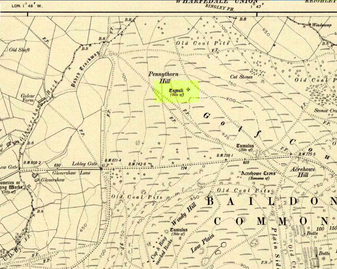
Highlighted on the 1909 OS-map of the area, on the top of the hill a short distance from the roadside, about 250 yards northwest of the Acrehowe Hill site (now at the edge of the golf course) could once be seen another prehistoric burial mound. The rediscovery of this tumulus was first announced briefly in the January 1905 edition of the Bradford Scientific Journal (issue no.3). A few months later the local writer and historian William Preston (1905) wrote a more detailed article on the site, telling the following information:
“A discovery of considerable interest to local archaeologists was made early in December, 1904, on the summit of the spur of moorland on the northwest of Baildon Moor, known as Pennythorn Hill.
“A workman engaged in removing stones from an extension of the golf course, unearthed an ancient cinerary urn containing calcined human bones, a flake of flint which may have served the purpose of an arrow point, a bronze instrument, and a perforated piece of bone, unfortunately broken during calcination. An examination of the site of the discovery revealed the remains of a tumulus, the upper part at some time removed, with a diameter as near as it was possible to tell, of about fifteen feet. In point of construction it differed little from others which are to be found in the locality. The vessel had been placed in an inverted position over the calcined bones, in a hole made in the sandy subsoil. There was no indication of the urn having rested in a cist.
“The earth beneath the urn bore no evidences of fire, and it is likely that the funeral pyre on which the corpse was reduced to ashes was not erected on the spot. It may be assumed from the association of the weapons named that the bones are those of a male person.
“The height of the urn is twelve and a half inches, it is eight and a quarter inches in diameter, and taper in the lowest third of its height to a base of about three inches in diameter. In the course of its excavation it was broken by the workmen, but it has been excellently restored in the laboratory of the Hull Museum…
“The urn belongs to the early British type and its date is, probably, well before the Roman invasion of the island. The general outline of the urn is very similar to that of some urns found by Canon Greenwell in the course of his exploration of the barrows of the north of England… The surface of the urn is divided into three zones. The upper part of the vessel consists of a raised border, about four inches wide, decorated with horizontal and vertical lines alternately arranged, and produced by pressing a twisted thong up0n the clay of which it was composed… Beneath the border and upon the central part of the body, a different form of decoration has been carried out. A zig-zag line scratched in the clay has been carried around the body, forming a number of triangular compartments, which were filled in with diagonal lines, giving he appearance of a herring-bone pattern. The counterpart this design does not appear on any of the urns figured by Canon Greenwell in his records of digging in British barrows.”
References:
Greenwell, William, British Barrows, Clarendon Press: Oxford 1877.
Preston, William E., “The Discovery of a Cinerary Urn on Baildon Moor,” in Bradford Scientific Journal, no.4, April 1905.
Wardell, James, Historical Notes of Ilkley, Rombald’s Moor, Baildon Common, and other Matters of the British and Roman Periods, Joseph Dodgson: Leeds 1869. (2nd edition 1881)
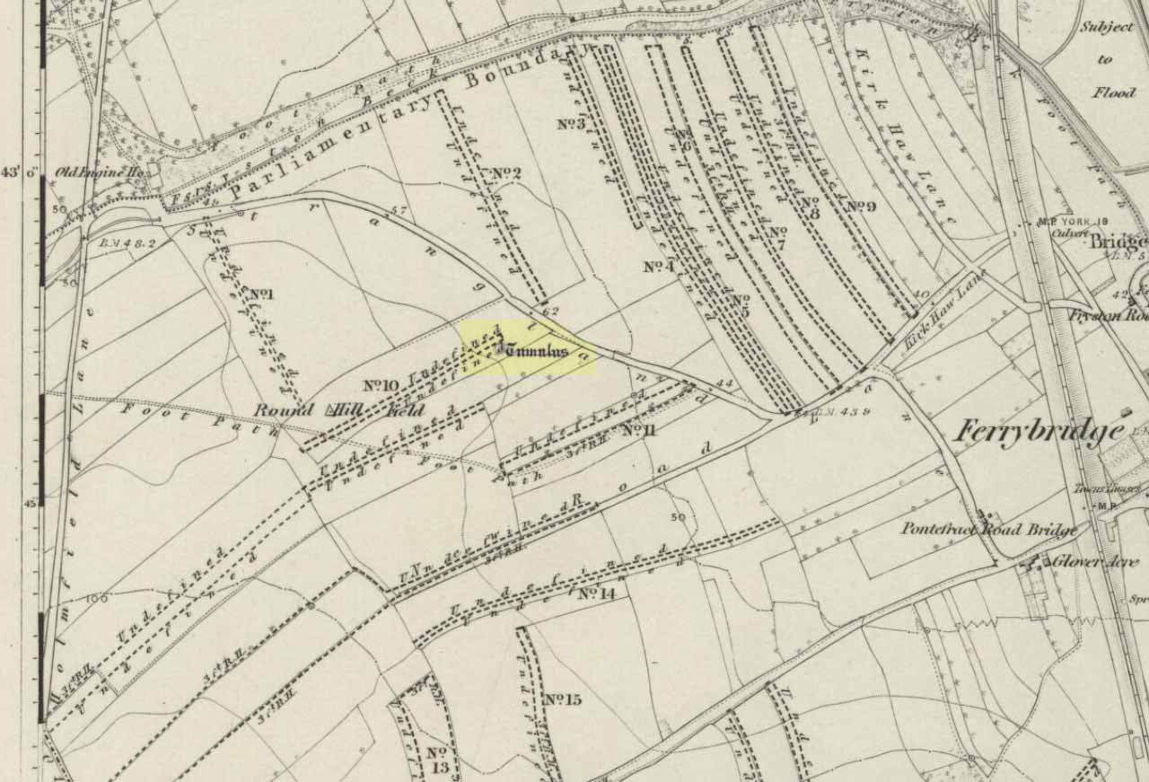
Tumulus (destroyed): OS Grif Reference – SE 4734 2449
Also Known as:
Mound 1 (Pacitto)
Roundhill Field
Archaeology & History
Pacitto’s plan of the tomb (after YAJ, 1969)
One of a number of sites that used to exist in this part of West Yorkshire before the coming of the Industrialists and their ecocidal ways. Found in conjunction with the Round Hill Field tumulus 53 yards to the south, this fallen monument was thankfully looked over several times before its final demise when the power station was built. The first literary account of it seems to be Forrest’s (1871) local history work, soon followed by another dig by the legendary tomb raider, William Greenwell. (1877) Both of these digs were very good indeed and give us the most detailed account of the remains here.
One of the urns found in the mound (Forrest 1871)
The name of this tumulus and the nearby Round Hill site needs some clarification before continuing to the archaeological account. In both Forrest and Greenwells’ accounts, they each named this site as the ‘Round hill tumulus’, but since their original fine work, archaeologist A.L. Pacitto (1969) and his team found the other previously unrecorded tumulus and surrounding ring-ditch in the original field called Roundhill field. Old records showed that a wall or fence once ran between the two sites, and that the tumulus which Forrest and Greenwell previously called the Roundhill site was actually located in the curiously named ‘Angel Moon field’ — hence the change of name in this (and Pacitto’s) account. (if y’ get mi drift) It’s an important point. So as you read the accounts below, where the authors describe the Roundhill tumulus, they are in fact referring to this, the Angel Moon tumulus. Gorrit? OK!
The site was noted for the first time as a tumulus by the local owner of the land here, a Mr Hall, in 1811, who wanted it levelled and attempted,
“to remove it altogether, but so many human bones were then met with, that after removing a considerable portion, it was abandoned, and the exhumed bones removed to the neighbouring churchyard of Ferryfryston.”
Mr Forrest then said:
“We are told by an eye-witness that on this occasion two plates of metal were found, but of what kind of metal pr what became of them we have no certain information.”
Thereafter began Forrest’s lengthy account of the initial excavation of the Angel Moon burial mound, undertaken (I think) by himself and other locals. Readers will hopefully forgive the lengthy profile I’ve given this place, but I know it will be of interest to local historians in the Pontefract and Ferrybridge area:
“This Tumulus, which is situated in Roundhill Field, on the left of the road leading from Ferrybridge to Castleford was first opened on March 28th, 1863. For the sake of ascertaining its structure, a trench was dug on the side not previously disturbed, to within a few feet of the centre, but without result, except ascertaining that the material gradually changed from sandy gravel to large stones as the middle was approached, and that it had been raised upon a natural swell of the strata, thus offering a dry situation; a condition about which the ancients appear to have been solicitous in choosing the sites of their sepulchral mounds. They then began to dig at the top, and immediately under the sod lay two human skeletons, one upon the other, with no more than six or eight inches of soil upon them. Near them lay portions of two antlers of…red deer, the uppermost skeleton was that of a tall adult male, the teeth nearly entire and in fine preservation, the other was of shorter but stouter proportions, the feet of both were gone, probably by the diggers in 1811, who it is conjectured had previously discovered these remains, and covered them up, with the few inches of soil, under which we found them; they had evidently not been removed, all the bones present being in their natural position, the whole of the bones and horns were much crushed and broken by the superincumbent earth which must once have covered them.
“With them were found several detached pieces of what appeared to have been the tusk of some animal, probably the wild boar, and fragments of half-baked pottery which on comparison were found to be portions of two urns of the early British type, such as are usually found in grave-hills attributed to that period. The smaller one (of which the principal portions were recovered) was of the size and much of the shape of an ordinary breakfast cup, three inches high, scored all over with vertical indentations as if by a piece of flint. The other was much larger, more elegant in shape, on which considerable taste was displayed in the ornamentation, composed of parallel lines, chevrons, zigzags and punctures, in which a dextrous use of the twisted thong was evident; this was ten inches high.
“About eighteen inches to the left of these, and a few inches deeper, lay the skeleton of another person, who had evidently lived to a great age, the teeth being worn nearly to the roots, tho’ showing no signs of decay. All the three lay east and west as in the present mode of Christian sepulture. No other human or animal remains were found, nothing metallic, or any implements, no appearances of cremation, no ashes, neither did the urns appear to have contained any, no stones to indicate that a cist had enclosed them, they had been buried in the soil, which here only differed from that surrounding it, in its somewhat darker colour.
“Digging downward, immediately under the skeletons first discovered, a large rough slab was reached at the depth of four feet from the surface. Its removal disclosed a stone cist or grave, of which it had formed the cover, composed of four rough stones set on edge, and paved with smaller pieces at the bottom; width at the head 2 feet, at the feet 1 foot 5 inches internal dimensions. It was entirely filled with small gravel, in which was interred the skeleton of an adult male, apparently of large stature, the thigh bones measuring in length 19¾ inches, the leg 16 inches. The knees were bent up in the manner in which such interments are usually found, and the face toward the south. The skull was accidentally broken, but well developed, and indicating the age about forty. The teeth were all present, and in beautiful preservation, the enamel white and bright as in the living subject. In front of the breast was an urn, laid on its side, of very coarse make, imperfectly baked, and so fragile, that on the most careful attempt to remove it, the urn crumbled into fragments, the whole was however collected, and sufficed to give a correct idea of its size, shape and ornamentation. It contained nothing but small gravel, like that in which it was laid. Near it was a small chipping of flint with a cutting edge, 2½ by 1¼ inches, this was the only article having any resemblance to a tool or implement hitherto met with.
“The cist being filled with gravel, I suppose to be an unusual circumstance. It could not have penetrated through any fissures in its sides, neither was the cist likely to have been opened subsequently, as nothing appeared to have been disturbed.
“Proceeding downward, it was seen that this cist was built upon and its sides supported by large rough stones inclined towards it ; the surrounding gravel was mixed with fragments of human bones, small pieces of urns, and occasionally bits of charcoal, and in a cavity a piece of wood was found but so decayed that its original shape or purpose could not be ascertained. Among the bones was a portion of a skull, showing a fracture from which the subject had recovered.
“At about the depth of seven feet, and a little to the east was a flat stone laid horizontally, length 4½ feet, width 3 feet, under this was a layer of dark earth two or three inches thick, totally different from that surrounding it, inodorous, and in which was no perceptible trace of animal remains, but exhibiting hollow casts of something resembling stone fruit about 1 inch long by ½-inch wide. Near this was found a thin stone of a round or oval shape about 6 inches broad, apparently chipped to shape and having a rough cutting edge ; its use can only be conjectured.
“At the depth of nine feet, the native rock was reached in which was a cavity about ten inches deep, but as far as could be ascertained containing nothing but gravel mixed with bones like the surrounding part.
“From observations then made I came to this conclusion: that the mound had been used for interments anterior to the formation of the cist, on which occasion, its upper part was levelled to make a convenient platform for it ; when the bones of former interments were disturbed and scattered about with as little respect for the dead as would a modern gravedigger; in making room for a new occupant.
“The fact of the three skeletons first noticed being interred after the Christian mode, is presumptive evidence that they were Saxons. It is well ascertained that this people had their coming here, frequently buried their dead in British tumuli, even after they had embraced Christianity, which occasioned an edict to be published in the year 987, prohibiting this practice, and providing that no Saxon should be buried in the tumuli of the Pagans, but only in the cemeteries of the churches, neither do urns nor antlers (which are undoubtedly British) militate against this supposition, when it is considered that they were all fragmentary, and as the skeletons with which they were, had evidently been disturbed though not removed, it is very probable that these fragments had been taken from that part of the mound removed in 1811, and thrown among these bones in the random manner in which we found them.
“From all these circumstances, this barrow appears to have had a very early and prolonged existence as a place of sepulture. The cavity in the rock was probably the grave of the first interment. The fragments of bones under and around the cist show that interment had taken place before its formation. The absence of any evidence of cremation either in the cist or elsewhere, shows that these interments were prior to the introduction of that ceremony from the nations with whom the Britons afterwards had intercourse. The absence of any weapon or other instrument save the single chipping of flint, and the roughly fashioned stone and the rudely found urn of clay, all go to prove that this was one of the very earliest of British Barrows. And if my hypothesis as to Saxon burial be admissible it will bring its sepulchral history down to the Christian era.
“At the upper end of the field are some earthworks of considerable depth, but as the whole is under cultivation, their form and purpose can scarcely now be determined.”
A few years later the legendary tomb raider Mr Greenwell and his mates turned up and gave the site their additional attention.
“On this occasion the digging commenced on the east side, where a deposit of burnt bones was found upon a flat stone just above the surface, and ten feet from the outside. Six feet to the north of this was another similar deposit laid upon the natural surface. Five feet south of the centre, was an unburnt body, doubled up and on its right side, with its head to the south. Immediately beneath, and in close contact with it, was a burnt body, apparently deposited at the same time. These interments in opposite customs present very interesting features in British sepulchral usage, as if the practice of cremation though at one period generally adopted, was not universal, but influenced by the wish of the deceased, or the inclination of surviving friends. With these remains were found an urn, of beautiful type, 4½in high, ornamented outside with twenty-seven thong markings, it would be impossible to decide to which of the bodies this belonged, such urns are found with both modes of burial.
“These deposits of burnt bodies were all found on the south-east side of the tumulus and consequently none were met with during the partial examination in 1863; but as the diggers in 1811 commenced at that point, they must have found and removed several such.
“As the work proceeded, the large flat stone covering the deposit of dark earth, was again met with ; and southward of this was another similar deposit also covered by a stone. In this earth was found a small seed pod or fruit, with striated markings, about nine lines in length, and black as the soil in which it was found ; its size and shape suggest the idea, that such fruit might have been the occasion of the hollow cists observed in the first discovered deposit. Close to these deposits was one of very dark sand, inclined to dark red or chocolate colour in some parts, this had evidently been subjected to the action of fire.
“The tumulus was so far removed, as to reveal the nature of the surface on which it had been built, which proved to be a natural outcrop of the limestone rock, and upon it these dark deposits were found. Their origin and purpose, offer an interesting subject of enquiry to the Archeologist. Their situation on the edge of the projecting rock is suggestive of their sacrificial character, or their connection with some of the druidical rites of the ancient Britons. The burnt sand may mark the site of the place where the act of cremation had been performed.
“The next object of interest was the rock grave, the edge of which had been reached in 1863, but reluctantly abandoned. This was found, and proved to be a large circular one, nearly six feet in diameter, and two feet six inches deep. At the west end was a rudely-formed cist, filled with gravel like the first one, in which was found a body, bent up in the usual manner, lying on its right side, and with its head to the south-west. At its feet was a drinking cup laid on its side, height seven inches, profusely ornamented with thong markings, consisting of three sets of horizontal lines filled up between with vertical lines, below these, and between two more horizontal lines, was a line of zigzags, the lower triangles of which were filled up with horizontal markings. The same pattern occupied the upper and lower halves of the vase. In the hollow of the knees was found a bronzed pin much oxydized, about 1½in. long, this might have been used to fasten some portion of the dress in which the person had been buried. It was the only piece of metal found in the tumulus, with the exception of that found in 1811, which is now supposed to have belonged to an Anglo-Saxon, buried with sword, spear, shield, etc.”
Then in 1962 came the final examination here, shortly before the site’s destruction. Pacitto (1969) and his team didn’t really find much more than his Victorian predecessors, apart from a couple of flints, some other fragments of bones and some modern bits and bats. However,
“The mound was surrounded by two concentric ditches, respectively 55ft and 75ft in diameter. The outer ditch was only a few inches deep, but the other had been cut into the limestone (my italics, PB) to a depth of 2ft 6in”
References:
Forrest, C., The History and Antiquities of Knottingley, W.S. Hepworth: Knottingley 1871.
Greenwell, William, British Barrows, Clarendon Press: Oxford 1877.
Pacitto, A.L., “The Excavation of Two Bronze Age Burial Mounds at Ferry Fryston in the West Riding of Yorkshire,” in Yorkshire Archaeological Journal, volume 42, part 167, 1969.
Roberts, I. (ed), Ferrybridge Henge: The Ritual Landscape, WYAS 2006.
Tumulus (destroyed): OS Grid Reference – SE 4733 2444
Also Known as:
Mound 2 (Pacitto)
Roundhill Field
Archaeology & History
Tumulus on the 1852 map
Close to the important ceremonial monument of Ferrybridge Henge could once be seen be this singular grave and ring-ditch, 53 yards north of the curiously-named Angel Moon tumulus. But, thanks to that regular ingredient of self-righteous industrialism, neither of the sites exists anymore. It had initially been damaged by some agricultural ignorance (they like to the PR-term ‘agricultural improvement’), but was thankfully rediscovered following excavation work on the Angel Moon site by A.L. Pacitto in April 1962, in advance of the construction of the Ferrybridge C power station. (in truth, the exact position of this Round Hill tumulus was in an area that has notbeen built onto, at the southeastern edge of the modern car-park on the grassy area next to the trees; showing that it could have easily been preserved).
Roundhill tomb skeletonRoundhill tomb plan
The site was certainly an important one amidst what Ian Roberts (2006) called “the ritual landscape” in this part of prehistoric Airedale. When the archaeological team came to do their work here, very little of the monument could be seen on the surface—Mr Pacitto described it as “barely perceptible”—but they were both pleased and surprised at what they found. Detailing their excavation work, Pacitto (1969) wrote:
“Natural rock was found immediately below the ploughsoil, and it had been scored by ploughing. In view of the complete lack of stratification the first traverse of the (Drott) machine was arranged so that it cut across the mound from side to side, with one edge coinciding with a line drawn through the centre. This first traverse exposed half an oval grave pit, measuring 3ft 9in by 5ft. On excavation it proved to be only 5in deep, but in spite of this it contained an undisturbed crouched inhumation. The body was on its left side, facing south, and a notched flint dagger behind the pelvis was perhaps attached to a belt at the time of burial. The dagger…is very neatly flaked from a fine flint with a pale blue patina. It has three notches on each side of the haft and is very similar to one found in Doncaster in 1935. The filling of the grave also included several fragments of human bone, one of which had been calcined.
“The grave was surrounded at a distance of 11ft to 12ft by the remains of a circular ditch. Only two segments of this had survived, representing less than half of the total circumference. Doubtless ploughing had destroyed much of the original rock surface.
“Outside the ditch and 20ft to the southeast of the grave was a small circular pit. With a flt bottom and vertical sides, it measured 2ft 3in in diameter and was 1ft 2in deep. The filling was mainly of broken and crushed limestone fragments, and there was no clue to its date or purpose. This pit was sited on the line of an east-west fault or joint in the rock.”
References:
Forrest, C., The History and Antiquities of Knottingley, W.S. Hepworth: Knottingley 1871.
Pacitto, A.L., “The Excavation of Two Bronze Age Burial Mounds at Ferry Fryston in the West Riding of Yorkshire,” in Yorkshire Archaeological Journal, volume 42, part 167, 1969.
Roberts, I. (ed), Ferrybridge Henge: The Ritual Landscape, WYAS 2006.
Until we’ve isolated this site, it’s difficult to suggest an age for it. It’s an all-but forgotten grave of some sort, last mentioned by John Clough (1886) in his rare work on Steeton township. Although the folklore indicates some medieval date here, the site may have been a prehistoric tomb, as it was located in the same valley a mile east of another little-known prehistoric burial at Crosshills. Mr Clough wrote the following of the site:
“Until AD 1790 the road to Kildwick would be down Pot Lane and past ‘The Lion’. Near a field, now called Nanny Grave Hill; there were four land ends; there are three lane ends yet; there was what i’s called Devil’s Lane, the lanes towards Eastburn and Steeton, and Wood Street… The junction of these four lane ends is the scene of one of Steeton’s tragedies. At this place is buried a suicide called Nanny, with “a stake in her inside.” Some people point out the mound under which she’s buried. When the suicide took place isn’t known, but it would certainly not occur later than the 17th century.”
But there are no records telling of the said ‘nanny’ and her death, nor archaeological accounts of any excavations hereby. The epithet nanny is sometimes used in northern counties to mean a witch, and although we have no remaining lore telling of such a character, the old name Devil’s Lane certainly infers some pre-christian or supernatural history hereby, common to many ancient burial mounds throughout Britain and across the world. Also a burial at an old crossroads is another heathen indicator; and the legend of the body having “a stake in her inside” is highly suggestive of further archaic death rituals, fixing the spirit of the dead at the site to prevent transmigration of any form, effectively ending the lineage of shaman or other heathen priestess. Any further information about this site would be most welcome.
References:
Clough, John, History of Steeton, S. Billows: Keighley 1886.
Takes a bitta finding this one! Take the B6265 road north out of Skipton, and about a mile along, turn left up the small road to Stirton village. But once on the level and the open countryside opens to your right, where there’s a notable bend in the road and a track goes up into the field, stop! Walk up past the closed fields and, where the open country starts, veer to the left track (not up the official footpath). Keep walking up here till you’re approaching the bend in the old walling; but veer into the grasses, right, about 50 yards before it. Good luck!
Archaeology & History
Very recently, Mr Paul Hornby called us to come and check a number of features he’d come across on a portion of open countryside not far from Skipton. At the very least it was gonna be a nice day out, ambling abaat and seeing some potentially new prehistoric sites — and we weren’t to be disappointed!
Close-up of cupsSingle cup-mark nearby
Although this site aint much to write home about, it is found close to a number of other recently rediscovered prehistoric features. Upon a fairly large stone a coupla hundred yards east of a supposed tumulus to the southern ridge of Sharp Haw, we find an arc of three cup-markings on the rock’s northeastern face, with a possible fourth cup along the same line (though I aint sure misself). And that’s it I’m afraid. Nowt else. (and I’ll try getting some better images when we’re next up there) Another stone nearby to the west has a near-perfect single cup-marking on its flat surface.
ACKNOWLEDGEMENTS:
Huge thanks to Paul Hornby for the use of his photos!
This little known site, long since destroyed during the construction of Keighley Railway Station, was found in a curious spot, close to the bottom of the Aire Valley. Most (known) prehistoric burials occur on the higher grounds in this area. And though we don’t appear to have the exact location of the find, it was pretty close to either side of Keighley’s old railway station (which is shown as 100 yards to the other side of the road of the present station on the 1852 OS map). This may position the site as being on the grounds opposite and below St. Anne’s Church; otherwise it was getting closer to where the River Worth runs by. In Keighley & Holmes’ early (1858) work they told that,
“Whilst excavating for the Railway within about a hundred yards of the Keighley station, one of the labourers discovered three urns containing a quantity of human bones. Two of them were unluckily broken, one being large enough to hold eight or nine quarts. The one brought away whole, and seen by the present writer, may hold about a quart; it is somewhat distastefully designed, moulded by hand out of the common clay, without glaze, and rudely ornamented on the outside by some sharp implement. The once animated contents of each urn were covered by a square flat stone.”
This final remark seems to indicate the urns were located in a cist (a small stone grave), but we don’t know whether this was found within the remains of a denuded tumulus or stone cairn. However, considering the lack of any remarks about a large pile of stones (which would have been very noticeable) covering this burial site, it would seem more probable that this site was originally an earth-covered tumulus, whose visibility and knowledge had long since diminished in this part of Airedale.
References:
Keighley, William & Homes, Robert, Keighley, Past and Present, R. Aked: Keighley 1858.
Go northwest along the country lane running between High Utley (on the outskirts of Keighley) and Steeton known as Hollins Lane, which then becomes Hollins Bank Lane. You’ll see the fine castle building as you go along, known simply as The Tower arising from the top of the tree-line. As you get to the driveway leading down to the Tower, a less impressive farm building is on the other side of the road, known as Hollins Bank Farm. On the right-hand side of this house is an old overgrown road. Walk along here to the end, going into the field immediately left where a small group of stones can be seen halfway up the field by the tree. You’re here!
Archaeology & History
First discovered one sunny afternoon on April 7, 2010, in the company of Buddhist scholar Steve Hart, this is a really curious carving, inasmuch as it seems to have been deliberately carved around what may be curious naturally eroded cup-forms. You’ll have to visit it to see what I mean. They’re a bit odd. Almost too perfect as cups to be the ancient eroded ones we’re used to looking at. But this aside….
…and againDragon Stone, looking NW
It’s a lovely flat stone, with curvaceous lines running across the middle and edges and into cup-markings. Although some of the cups give an impression of being natural, others have the authentic-looking ring to them, with at least one of them possessing a near-complete ring encircling it (as you can faintly see in the close-up photo here). There are at least 19 cup-markings on this stone, and four main ‘lines’ running roughly in north-south directions, with the cups interspersed between them. At the top (north) end of the rock, separated by a crack, the lines stop and we just have some cup-markings. The crack in the stone may have been functional here.
Although graphically different, the carving has a similar feel in design (for me at least) to that of the Wondjina Stone at Rivock Edge, on the other side of the Aire Valley a couple of miles east of here — though this newly found carving is in a better state of preservation. The small scatter of rocks around it seem to have been unearthed or moved recently by the land-owner (who aint keen on you looking on his land, so be careful) and the good state of preservation may be that they were only unearthed sometime this century. We must also keep in consideration that the lines that run across the surface of this stone are water-lines and may be more the result of Nature’s hand than humans. It’s obvious that some human intervention has occurred here, but it may be difficult to ascertain the precise degree of affectation between the two agencies.
Close-up of cups & lines
According to the archaeological record-books there are no carvings here, but another simple cup-marked stone accompanies this more extravagant serpentine design just a few yards away; a simple cup-marked stone may be seen at the top of the hill; and the faint Currer Woods carving can be found 0.68 miles (1.09km) due west of here, on the other side of the small valley. Other outcrop stones scatter the fields and slopes here, some of which still need checking to see whether or not further carvings exist.
…And for those who may bemoan my seemingly romantic title of the carving: remember! — close by in Steeton township, between the years 1562 and 1797, there was an old field-name known well to local folk, of “one parcel of arable land in town field called Drakesyke, 3 acres”, i.e., the dragon’s stream or dyke. (Gelling 1988; Smith 1956)
References:
Clough, John, History of Steeton, S. Billows: Keighley 1886.
Gelling, Margaret, Signposts to the Past, Phillimore: Chichester 1988.
Smith, A.H., English Place-Names Elements – 2 volumes, Cambridge University Press 1956.