Head out of Doune village and take the A84 to Stirling. Just a few hundred yards along, over the old river bridge, take the first right along the B8032 (don’t head into Deanston). Barely 500 yards along on the left-hand side, between the farmhouse and a small group of houses, note the large tree-lined mound in the middle, just over the fence. It’s quite a big fella – you can’t really miss it.
Archaeology & History
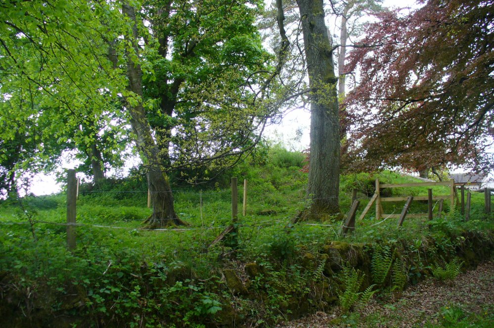
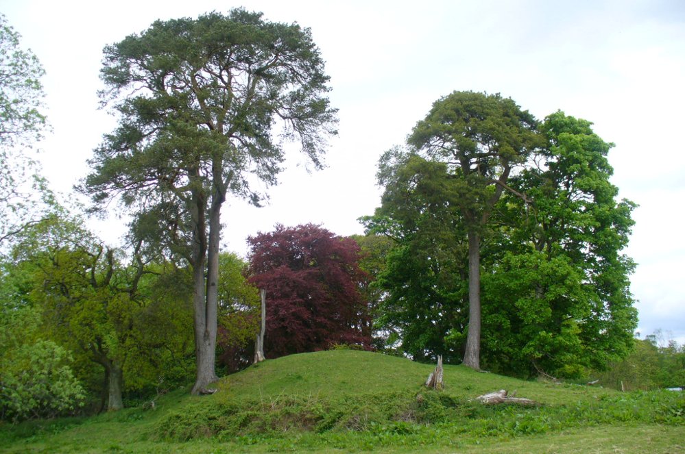
The mound and its trees
This is an almost archetypal fairy mound of a monument—and a mighty one at that!—living quietly in the field with its olde trees for company. Despite its size, it has brought little by way of archaeological attention and has, to my knowledge, never been excavated. Probably a Bronze Age burial mound, the tomb stands more than 15 feet high and is some 30 yards across east-west and 35 yards north-south. The Royal Commission (1979) listing of the mound says simply that “this large cairn measures 34m in diameter and up to 5m high.”
References:
Royal Commission on the Ancient & Historical Monuments of Scotland, Archaeological Sites and Monuments of Stirling District, Central Region, Society of Antiquaries of Scotland 1979.
From Balquhidder village, walk eastwards along the road for a few hundred yards until you reach Auchleskine Farm on your left. A short distance past here there’s a gate taking you into the rough field on the left. Go through here and note a large clump of rocks diagonally up the slope about 100 yards away. That’s your spot!
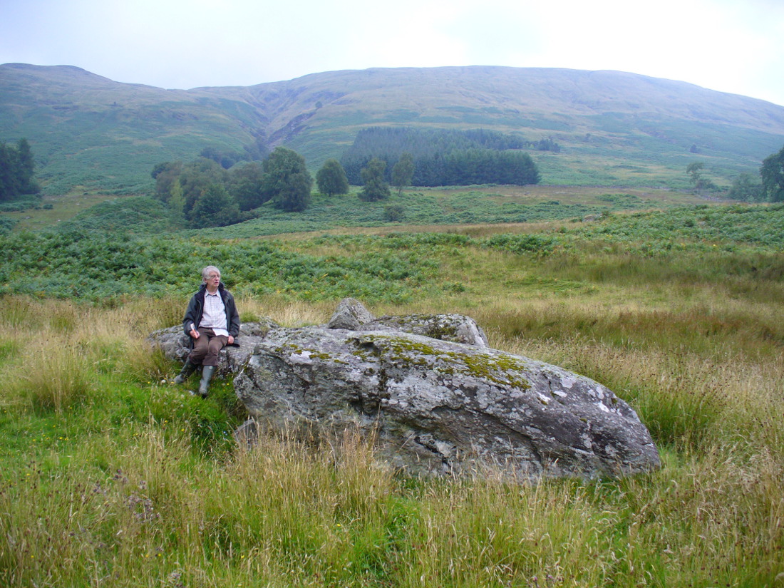
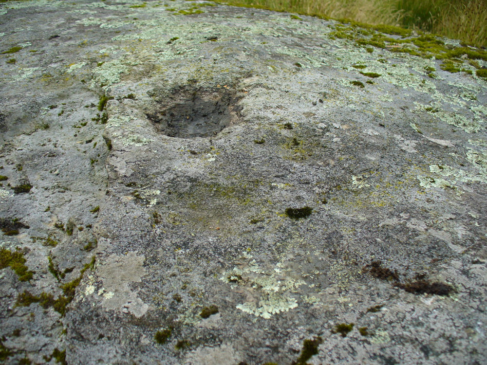
Archaeology & History
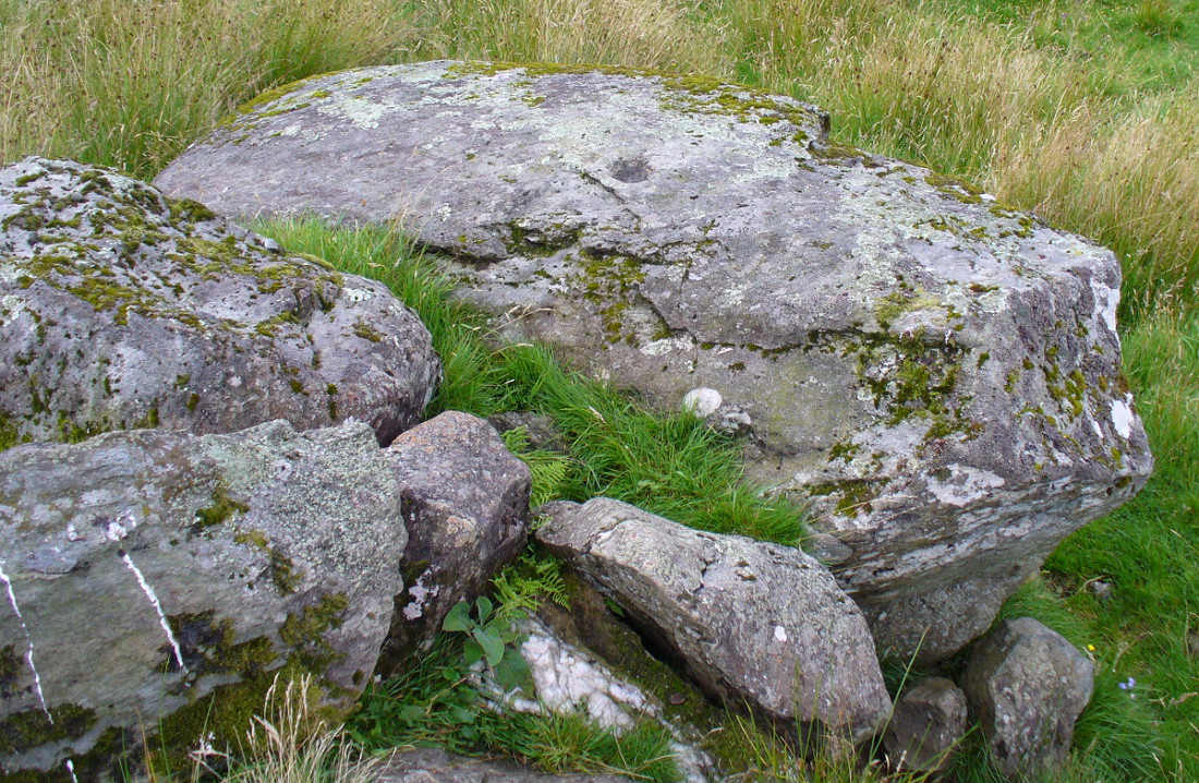
Very little has been said of this large cup-marked stone, just up from the road near Balquhidder. It was first found and described in J.M. Gow’s (1887) fine essay on the local antiquities of the area, where he told:
“About 400 yards directly east from the farm-house there is a group of three large water-worn boulders of coarse mica-schist, with veins of quartz, the largest of which is about 15 feet long, 7 feet broad, and nearly 5 feet above ground. On the top of this stone there are seven cup-marks of various sizes. The largest are 5 inches in diameter and 2 inches deep; the smaller ones are shallower and from 1½ to 2½ inches in diameter. There may have been more marks on this stone, as a portion of the top near the marks has been broken off, and there are several other faint hollows, but, in my opinion, not sufficiently pronounced to indicate that they ever were cups.”
Cupmarks on top of the rockThe carving from above
Although his caution on the number of cups on the stone is to be commended, it was obvious during our visit to the site a few days ago that there are at least 18 cup-marks on the surface of this large rock. There may be more (the grey cloudy day and misty light wasn’t good in allowing us to see the carving clearly). The most pronounced of the cups are on the very top of the stone, whilst others were carved mainly on the eastern slope of the rock.
At least two other cup-marked stones occur at the farmhouse itself, whilst on the road immediately below was once the cup-marked healing stone known as Clach nan Sul. It’s likely that other carvings are hiding away in the hills hereby…
References:
Gow, James M., “Notes in Balquhidder: Saint Angus, Curing Wells, Cup-Marked Stones, etc”, in Proceedings of the Society of Antiquaries Scotland, volume 21, 1887.
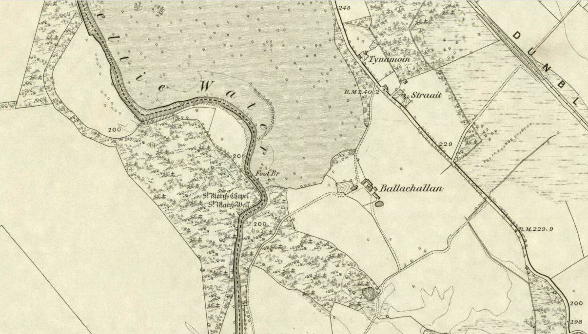
You’ll need wellies or no shoes for this excursion! From the lovely town of Callander, take the A84 road southeast out towards Doune and Stirling for a mile or so. Keep your eyes peeled for Straid by the roadside on your left and the turning right down to Ballochallan quarries. About 200 yards down, notice the industrial works on your left. Walk about 50 paces past this, then turn right into the trees. Less than 100 yards in, you’ll hit a shallow bend in the River Teith. Walk across and into the trees opposite…and if you amble just yards above the edge of the river, along the tree-line, you’ll find St. Mary’s Well…
Archaeology & History
Fresh waters of the quartz-lined spring
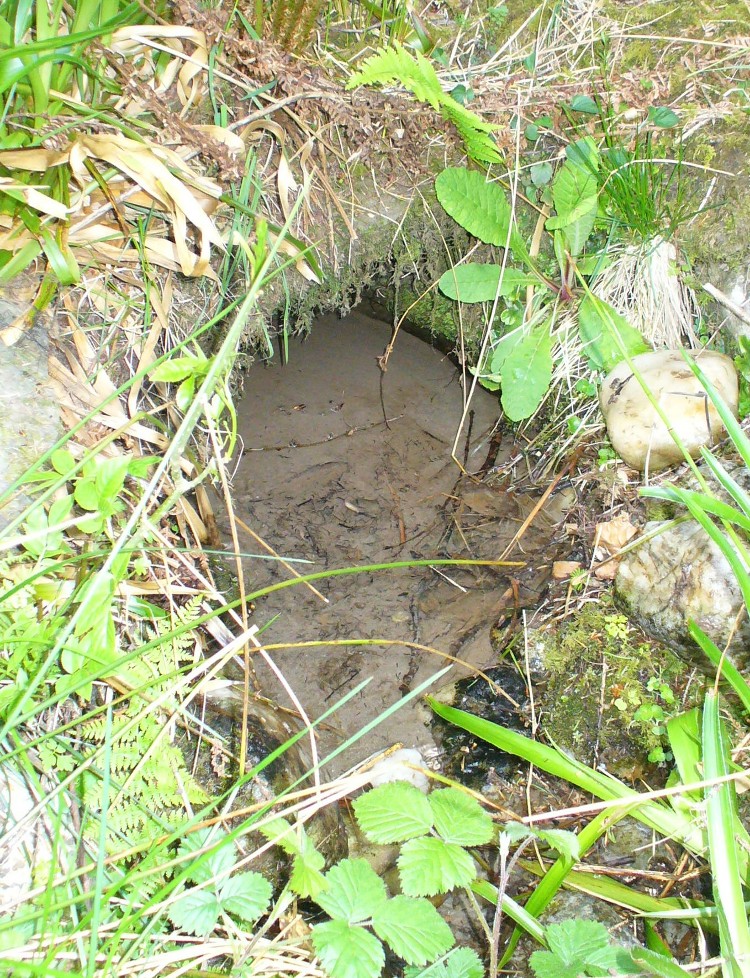
Highlighted on the 1862 Ordnance Survey map of Callander and cited in the Object Name Book of the same year, oddly there is no mention of this mythic site in the Scottish surveys on holy wells (MacKinlay 1894; Morris 1981) — which seems rather unusual considering the importance this legendary entity (St. Mary) possessed in the christian pantheon.
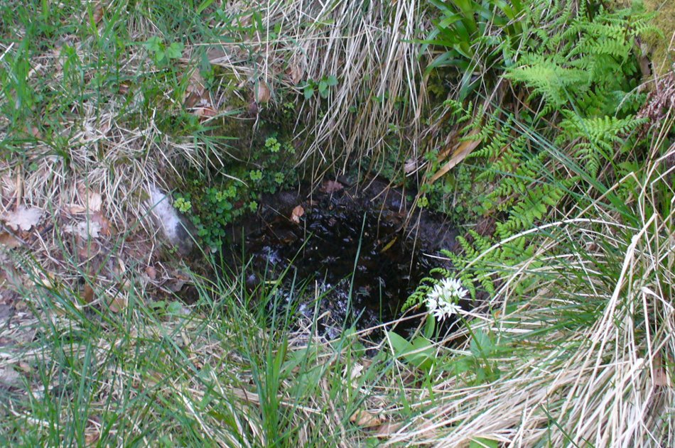
There is also some doubt about the precise position of this holy well. According to the Royal Commission account, the well “is stone lined; it measures 0.9m in diameter, and is choked with fallen leaves.” However, this appears to be the remains of a latrine (or “a bog,” as my northern tongue so eloquently exclaimed soon after finding it), now used more by frogs to lay their spawn in which their tadpoles thankfully emerge (as we found when visiting it last week). The holy well itself is about 10 yards further along the edge of the river and has a most curious architectural feature to it.
Stone-lined “well” 10 yards west of the real one
When we found the place, much of it was very overgrown indeed and it took a while to recover its status. But in doing so, we found that on all sides where the stone-lining marked the emergence of the waters, rocks large and small consisting almost entirely of quartz constituted the opening as it came out of the ground. This was a very deliberate construction feature no less! Also, the fine sandy silt which clogged up the waters were also found to have small pieces of quartz laying beneath it, seemingly as offerings that had been made here many years ago. But on the whole there seemed little evidence that the well had been used ritually for many years. So, once we’d cleaned up the debris and made the site more notable, I drank its waters and found them very fine and refreshing indeed!
In the trees behind the well you will find the overgrown remains of the old chapel, also dedicated to St. Mary. The tranquility and spirit of this place would have been truly superb. Even today, it is an ideal retreat for meditation and spiritual practice. It just seems such a curious mystery that nothing seems to be known of the place…
Folklore
The 1862 “Object Name Book” told that the waters here were renowned for having great healing properties. St. Mary’s feast day was August 15 and great were the country fairs and rituals surrounding this period across Scotland and beyond — many of which may have supplanted the more arcane festival of Lammas. However, local records are silent about any such events performed at Callander’s St. Mary’s Well. Do any old locals know more about it…?
References:
MacKinlay, James M., Folklore of Scottish Lochs and Springs, William Hodge: Glasgow 1893.
On the level ground a half-mile south of the large Fairy Knowe prehistoric tomb, Bridge of Allan had a site of its own up until being destroyed sometime in the 19th century. Nothing much is known about the tomb – or “cist containing a skeleton”, as the Royal Commission (1963) lads called it – apart from the notes given in J.E. Alexander’s (1868) essay on the Fairy Knowe, where he told:
“It is right, however, to mention, that a few years ago, in digging the foundations of the house of Annfield, Bridge of Allan, at nine feet from the surface, there was found in the sand, and apparently undisturbed, a fine cist, containing the skeleton of a young female; and under the right arm was a small clay urn, corroborating the opinion of Professor Innes, that in many cases the so-called urn was simply a domestic jar to contain food for the deceased.”
A Mr R. Swift from Bridge of Allan told that the cist was located at the newly-named Lentran, along Kenilworth Road. Does anyone know anything more about it?
Royal Commission on the Ancient & Historical Monuments Scotland, Stirlingshire: An Inventory of the Ancient Monuments – volume 1, HMSO: Edinburgh 1963.
Healing Wells (destroyed): OS Grid Reference – NS 77 91
Archaeology & History
Old drawing of the lost wells
The old line drawing here is all that remains of a pair of healing wells that once bubbled up within their ancient stone well-houses, close to each other, in the middle of the old woods west of Stirling in the massive quarries at Gillies Hill. It’s possible that the large pools of water that are now in the overgrown quarries are thanks to these ancient wells; although one of them was close to the old building of Fir Park, whose overgrown remains are within the woods at grid-reference NS 7787 9124. Very little has been written about these wells, but thankfully the local historian Mr Fleming (1898) captured their demise in his lovely antiquarian work, saying:
“The sketch, opposite (taken in 1850) of the picturesque wells, then situated in a marshy dell and surrounded by a dense pine wood near to the ancient ‘Boiling Springs’, now dried up by the sinking of the lime pits, and immediately off the old bridle road from Stirling to Glasgow by Murrayshall, shows very ancient remains of wells connected with the original water supply of Stirling by lead pipes from ‘Lessfeerie Springs’, situated in the Touch Hills. This supply was begun in 1774, and thus antiquity and interest are given to the sketch. These wells, with their fringes of mosses and ferns and bramble bushes, are now, with the pine wood, demolished, and the whole face of the district changed by the operations in a quarry recently opened up in Gillies Hill crag, causing the locality to be now unrecognizable.”
References:
Fleming, J.S., Old Nooks of Stirling, Delineated and Described, Munro & Jamieson: Stirling 1898.
This little-known holy well on the northeastern edges of the Touch Hills is another part of our ancient heritage that may well have been lost. All that now remains are the literary remnants telling of this once important site, around which local socio-religious elements occurred from time to time. When the local historian J.S. Fleming (1898) wrote about the site, it had already disappeared, and was himself fortunate to recover information relating to its former existence. He told:
“My attention has been drawn to an article which appeared in the Stirling Journal of 31st October, 1834, describing what is claimed to be a Holy Well dedicated to Saint Corbet, or probably Saint Cuthbert. The well was situated in Touch Glen, not far from Gilmour’s Lynn, and was, even at that time, reduced to a spring one foot deep and three or four feet in circumference, surrounded by boggy ground. The writer states that there were people then alive who had resorted to this Well in their younger days. Its virtues were restricted to one hour in the year, and that the hour of sunrise on the first Sabbath of May; the supposition being that by drinking of its waters at the Well by the adventurous pilgrims to such a wild and lonely spot at early sunrise, the devotee was assured of the preservation of his life during that year. We have never come across this Saint’s name, but Saint Cuthbert had an altar in the Rude Kirk (High Church of Stirling) and, as for the Well, from its diminishing condition in 1834, its site no doubt has long been obliterated.”
It is possible that some remnant of the waters here can still be found, or are known about, by dedicated local practitioners—but without their aid, this sacred site may be forever lost…
Folklore
In Thomas Frost’s (1899) essay on the holy wells of Scotland, he echoed what Mr Fleming had told, saying:
“Of St. Corbet’s Well, on the top of the Touch Hills…it was formerly believed that whoever drank its water before sunrise on the first Sunday in May was sure of another year of life, and crowds of persons resorted to the spot at that time, in the hope of thereby prolonging their lives.”
This restorative folklore element, implicit in the nature of water itself, was obviously related to the cycles of renewal in the social activity of our peasant ancestors, as found in every culture all over the world. (Eliade 1959; 1989)
One account relating to the disappearance of St. Corbet’s Well told that it fell back to Earth as the spirit of the site was insulted by profane practices. Janet & Colin Bord (1985) told that:
“This theme, of real or imagined insult to the well causing it to lose its power, move its location, or cease flowing altogether, is widespread. St. Corbet’s Well on the Touch Hills (Stirling) was said to preserve for a year anyone who drank from it on the first Sunday in May, before sunrise, and it was visited by great crowds at the height of its popularity. But the drinking of spirits became more popular than the drinking of well water, so St. Corbet withdrew the valuable qualities of the water, then eventually the water itself stopped flowing.”
References:
Andrews, William (ed.), Bygone Church Life in Scotland, W. Andrews: London 1899.
Bord, Janet & Colin, Sacred Waters, Granada: London 1985.
Eliade, Mircea, The Sacred and the Profane: The Nature of Religion, Harcourt, Brace & World: New York 1959.
Eliade, Mircea, The Myth of the Eternal Return, Arkana: London 1989.
Fleming, J.S., Old Nooks of Stirling, Delineated and Described, Munro & Jamieson: Stirling 1898.
Frost, Thomas, “Saints and Holy Wells,” in Bygone Church Life in Scotland (W. Andrews: Hull 1899).
Chambered Cairn (destroyed): OS Grid Reference – NS 58 76
Also Known as:
Blochairn 2
Canmore ID 44421
STR 3 (Henshall)
Archaeology & History
Close to the ruined Craigmaddie Muir cairn could once have seen a companion, of roughly the same size and structure and made up of thousands of small stones, covering a long internal chamber. It was described in David Ure’s (1793) early history work on the area which, even then, thanks to “frequent dilapidations, will soon be annihilated.” The cairn was included in A.S. Henshall’s (1972) magnum opus in which she wrote:
“There was a second cairn in the vicinty of Craigmaddie Muir I. It was also ‘of an elliptical shape.’ Writing in 1793, Ure says that it ‘was laid open last year, and, though not so large as the other, was of the same construction, which seems to be Danish. Some of the stones placed in the rows at the bottom are considerably large… Among the contents, upon opening…were urns… One of the fragments of an urn is ornamented, near the mouth, with two shallow grooves. The diameter of the circle of which it is a segment seems to have been at least 20in.”
Fragments of human bones were also found within the site, but the entire cairn was sadly destroyed a long time ago. In the Stirlingshire Royal Commission report (1963:1) it was speculated that the urn found herein,
“must have been either a neolithic vessel or a cinerary urn. In view of the method of construction of the chamber it may be assumed that both cairns were related to the Arran or Clyde-Carlingford types.”
References:
Henshall, Audrey Shore, The Chambered Tombs of Scotland – volume 2, Edinburgh University Press 1972.
Royal Commission on the Ancient & Historical Monuments, Scotland, Stirlingshire – volume 1, HMSO: Edinburgh 1963.
Ure, David, The History of Rutherglen and East Kilbride, Glasgow 1793.
An impressive prehistoric cairn of some considerable size was in evidence on the lands of Old Sauchie, near Sauchie farmhouse, until the Industrial Age brought an end to its presence. First mentioned in the New Statistical Account (‘Stirlingshire’, volume 7), the Royal Commission lads reported,
“Nothing now remains of the cairn that once existed ‘on the lands of Sauchie’, about 3 miles SSW of Stirling. It was examined in the early 19th century and is said to have measured more than 20ft in height and 90ft in diameter, to have been made of stones, and to have contained two cists, one somewhat larger than the other. It is possible that Wilson (1863) is referring to this cairn when he mentions a quantity of ‘silver coins recently found in a cist exposed on the demolition of a cairn on the lands of Sauchie.’ The coins were very thin, and were described as having been ‘struck through from the back,’ with ‘figures’ on one side only. Some of them had loops for suspension, and there can be little doubt that they were silver bracteates. All have been dispersed and lost.”
If anyone has further information about this obviously important and seemingly lost site, please let us know!
References:
Royal Commission on the Ancient & Historical Monuments, Scotland, Stirlingshire – volume 1, HMSO: Edinburgh 1963.
Wilson, Daniel, The Archaeology and Prehistoric Annals of Scotland – volume 2, Sutherland & Knox: Edinburgh 1863.
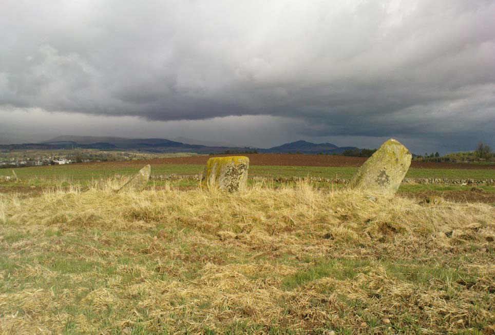
Take the B824 road that runs between Dunblane and Doune and, whichever direction you’re coming from, watch out for the large statue of David Stirling by the roadside (y’ can’t really miss it!). Stop here. Then, walk along the dirt-track into the field by the side of the statue, keeping your eyes peeled 50 yards along, for the upright stones in the field on your right, at the top of the brow of the hill.
Archaeology & History
Glenhead Farm standing stones
A few hundred yards south of the large Glenhead Standing Stone, we come across this curious small row of three reasonably large standing stones which — the more you look at them — give the distinct impression that they may be the remains of a large prehistoric tomb. But archaeology records are silent on this matter and we must contend with what we can see. At the northernmost end of the row, a fourth stone lays amongst the vegetation: it may have once stood alone, or maybe been snapped from its fellow monolith. 20 yards south is a large mass of stone; perhaps from an old building, perhaps cairn spoil (does anyone know?)
The local historian Moray Mackay (1984) thought that the line of stones here were once a part of something larger, saying:
“Originally it was probably a circle of six stones, with a seventh in the middle, and this central stone can still be identified by its flat top on which are the mysterious and well known cup-marks, much weathered but plainly visible. Close to the site, urns and stone hammers were unearthed last century.”
Glenhead stone row, looking north
Of the three remaining upright stones, it is the central one which has the cup-markings visible on its top and side (Allen 1882), with a lovely covering of almost luminous lichen giving it extra effect! (a separate TNA Site Entry for the cup-marked stone will be written in due course)
The famous astroarchaeologist Alexander Thom and his son (1990) described the place as,
“A three stone alignment showing about 33° N declination in one direction and 31° S in the other, but the azimuth comes from the stones only and so cannot be accurate. Perhaps the line is lunar to the hill in the SW…”
In Thom’s (1967) earlier work he posited that the alignment may relate to the rising of the star Capella around 1760 BC, but this is untrue. Thom’s error however, was not of his making, but due to the false dates that archaeologists ascribed to megalithic ruins at the time – dates which Thom used in his research, believing that the archaeological fraternity would know what they were talking about! In their collaborated text, Aubrey Burl added how,
“these stones stand on a hill summit at 360ft (110m) OD. The row is on a north-facing slope. Three stones stand. A fourth, prostrate, 6ft 6 in (2m) long, lies against the NE pillar. The row has a NNE-SSW axis. The northernmost stone is 3ft 6in high, the centre 4ft, and the SSW, characteristically the tallest, 6ft 6in… The line is about 27 feet (8.3m) long. The central stone has 23 cupmarks on its top and 4 more on its western side.”
…to be continued…
References:
Allen, J. Romilly, “Notes on some Undescribed Stones with some Cup-Markings in Scotland,” in PSAS 16, 1882.
Burl, Aubrey, From Carnac to Callanish, Yale University Press 1993.
Take the A820 road from Dunblane to Doune. About a mile west of the motorway, keep your eyes peeled for where the small road on your right is signposted to Argaty and Kilbryde. Stop here and walk up the footpath on the left-hand side of the road. A couple of hundred yards up, take the right turn on the track and where the small copse of trees is, go through the gateway, keeping yourself to the left edge of the trees running parallel to the field. About 100 yards or so up, you can’t miss him!
Archaeology & History
Quite a huge fella this one! Standing more than 6 feet high, the monolith is nearly as broad, giving an impression of great size to the old stone. The stone’s nature and date is troublesome: although ostensibly labelled as Bronze Age, alongside the walling which runs down from here we see a great number of other large stones, some of which give the distinct impression of being length of Iron Age walling — but without excavation, its nature remains a puzzle. The monolith stands close to being on top of a rise in the land, which geomancers understand as being important sites of spirit, or places where the dead were rested — but we have no record of any tombs here, so are left with the options of walling or a spirit site.
…and from another angle
On its east-face, the stone has a number of what appear to be curious large cup-markings, but they appear to be little more than the effect of weathering and erosion. There’s also a solid piece of long metal sticking out of the same side, which was obviously done by someone in recent centuries — so maybe a local farmer and his mates stood this one up? Or they were planning on using it as a gatepost…
The site is well worth looking at, best in the winter months when access is easier. It has the feel of other sites close by, hidden from the record books, though probably long gone.
References:
Royal Commission on the Ancient & Historical Monuments Scotland, Stirling – 2 volumes, HMSO: Edinburgh 1963.
Royal Commission on the Ancient & Historical Monuments of Scotland, Archaeological Sites and Monuments of Stirling District, Central Region, Society of Antiquaries of Scotland 1979.