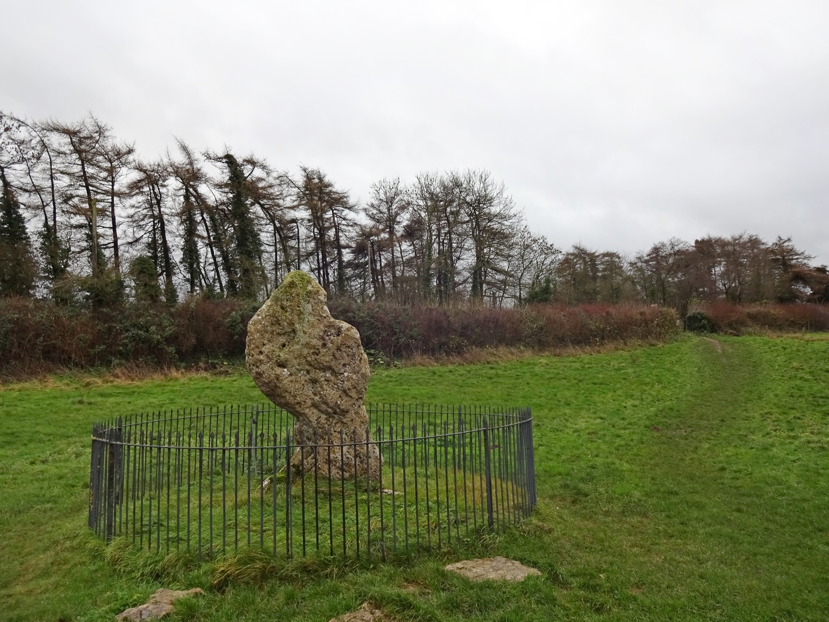
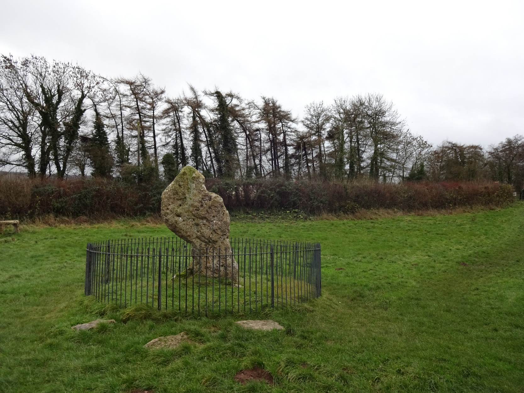
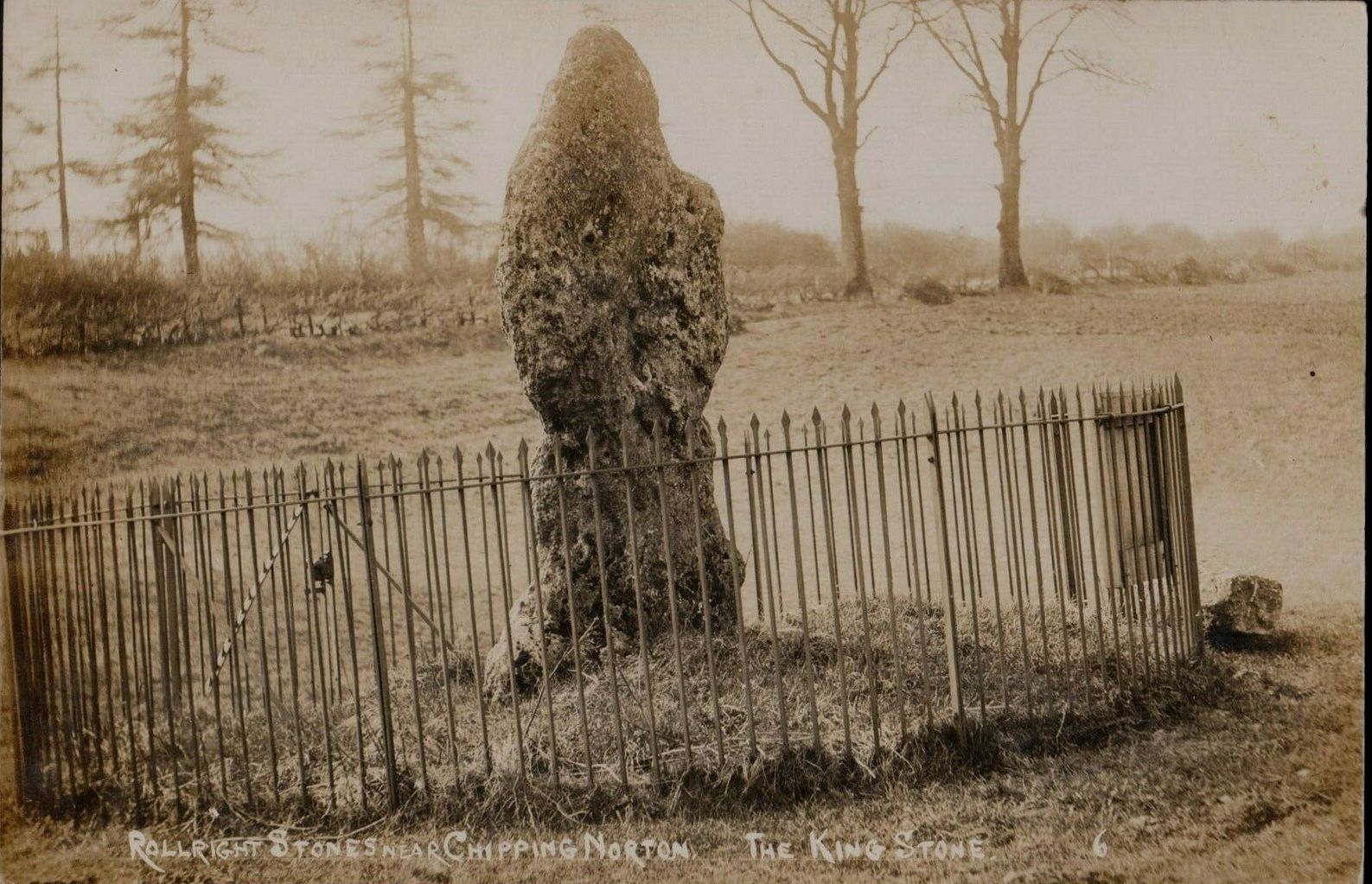
The King Stone of Rollright (photo by Sir Wilson III)
If you’ve reached the impressive Rollright Stone circle, simply cross the road, go through the gate and into the field, then up the gentle slope to your right. Y’ can’t miss it! If though, by any chance, you can’t find the Rollright Stones, get to Chipping Norton and ask a local!
Archaeology & History
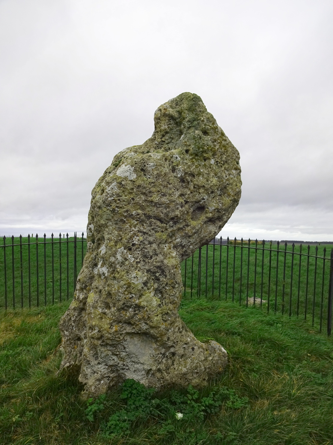
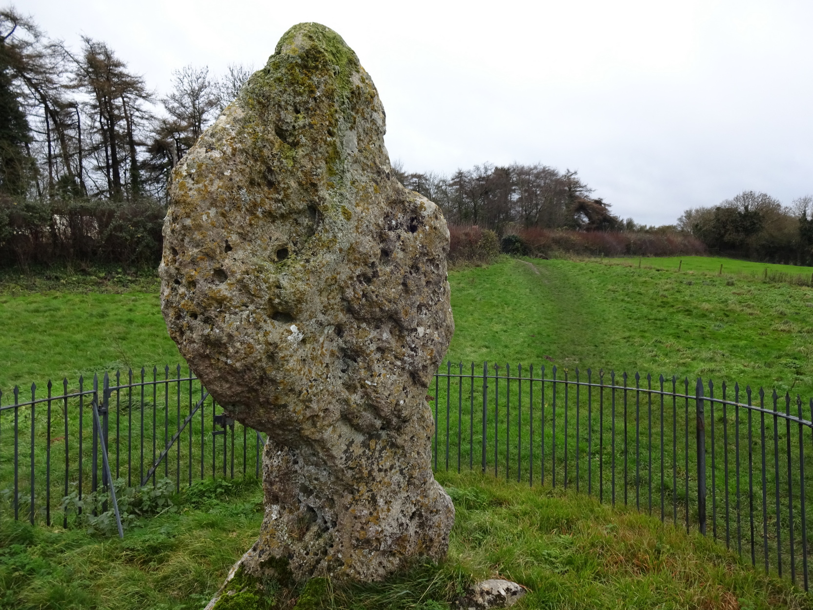
An integral part of the Rollright Stones complex, this gnarled almost moth-eaten-looking standing stone, whose edges were cut away for medicinal properties in earlier centuries, still awakes each morning beside the small rise in the field, long thought to have been the remains of an ancient tomb — much to the archaeologist’s opinionated disdain in bygone years. Yet they had to swallow their pride…
This is an eight-foot-tall standing stone made from the same local oolitic limestone as the King’s Men and overlooks the village of Long Compton on the northern side of the ridge. It actually stands besides an artificial mound which has been identified as a Bronze Age cairn—known in times past as the ‘Archdruid’s Barrow’— and suggested by Lambrick to date from around 1800 BCE. More recently however, the world’s leading authority on stone circles, Professor Aubrey Burl, has given the King Stone a more probable construction date of 3000 BCE. The date is consistent with other Neolithic finds in the adjacent fields. This old standing stone has suffered much down the centuries, with bits of it being chipped away to such an extent that it has been reduced to the novel shape we see today.
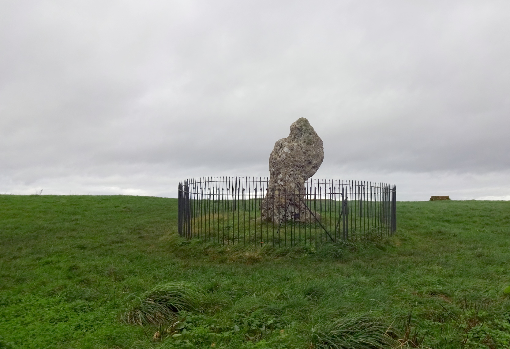
Looking up at the King (photo by Sir Wilson III)The King in dance
A little-known but important piece of megalithic history took place here in the 1970s and ’80s. It centred around an idea to investigation so-called “mysterious events” that are commonly reported at standing stones—and the King Stone has its own CV when it comes to such things. Curious stories have been described by people from all walks of life. Down the years, a number of people have told me of feeling some strange and powerful ‘energy’ at these places and stories of such things have filled many volumes, along with being the subject of many a folktale. So one evening in November, 1977, the then editor of The Ley Hunter, Paul Devereux, convened a meeting where twenty people from differing backgrounds gathered. At this first meeting were people from a variety of professional backgrounds: archaeologists, dowsers, chemists, biochemists, biologists, electronic engineers, geochemists, geophysicists, zoologists—and ley hunters of course. It was time, they thought, to address this issue of anomalous energies at stone circles and other ritual sites.
After some discussion about what they should call their investigations, “the long association of the dragon with some kind of earth force made it a fitting symbol.” And so, the Dragon Project (DP) was born…
On the misty morning of Saturday, 24 October, 1978, research scientist Don Robins—in the company of his dog and young son—drove the hundred miles from London to the Rollright Stones armed with a simple ultrasound detector. He didn’t know what he would find there, and his scientific training told him there shouldn’t really be anything untoward.
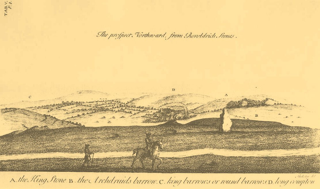
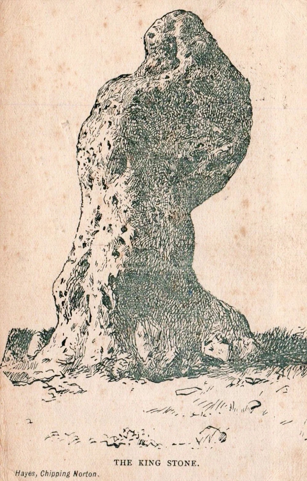
King Stone, looking W (photo by Sir Wilson III)Stukeley’s 1743 sketch showing the King Stone
Arriving around dawn, Robins took several background readings along some of the lanes a mile or so away and found the usual expected background levels (on a scale of 1-10, the background flickers between 0 and 1). When he eventually walked into the Rollright stone circle with his ultrasound monitor, no undue perturbations were found. He spent thirty minutes here, but at no time did he record anything other than background readings. So he crossed the road and tried the same at the King Stone—where a big surprise awaited him.
Switching on the detector he found an anomalously high reading, beating every minute or so, not unlike a heartbeat, more than five times above the background ultrasound!
“This was really peculiar,” he wrote, “in that the pattern was spread over about a minute and then commenced again after about 10 seconds, endlessly repeated.” Robins spent some time here and found that the strange ‘pulse’ wasn’t solely confined to the King Stone, but spread some distance around the old standing stone and onto the road itself.
Investigation of potential radiation anomalies was another avenue of enquiry explored by the Dragon Project, and although thousands of hours of monitoring were done at the three focal sites, there were few anomalies to write home about. Two however, were recorded in March and August, 1981, when radiation levels were twice the normal background rate for short periods of just a few minutes each. More puzzling was the finding—which can still be verified today—of radiation levels three and four times above background on the road between the circle and the King Stone.
Next on the list was an attempt to monitor the Rollright stones with infrared devices. This proved to be a potential goldmine, as there was the chance of photographic imagery. So early one morning in April, 1979, Paul Devereux readied himself at the King Stone. He took a number of photos at five minute intervals either side of sunrise. This time of day was chosen because of the repeated anomalous ultrasound emissions from the King and it was thought that this, if any, would be the best time to capture something on film.
“When the first roll of black-and-white IR film was professionally developed,” he wrote, “I was astonished to see a curious ‘glow’ effect around the King stone on the frame taken at sunrise.” His first account of it appeared in The Ley Hunter, where he described how “a hazy glow can be seen clinging to the sides and upper parts of the megalith. This glow becomes much stronger at the top of the stone where it looks like a cap of light.” Although the sun had risen, it was off to the left of picture and apparently no satisfactory explanation can be given to the effect on the plate. Research physicist Simon Hasler—who worked for Kodak—closely studied the negatives of this image and found the evidence for a simple explanation “weak.” A possible explanation of the mysterious glow was propounded by Don Robins, who suggested that an emission of microwaves from the stone may have been responsible, and although this sounds promising it has yet to be proven.
Folklore
(photo by Sir Wilson III)
Amidst the mass of modern lore, dowsed energy lines exceed here — although to be honest, most of them are little more than bullshit. Old school alignments in the form of leys that can be walked along are more credible, and one or two have been noted here. Dowser Laurence Main found a ley running between Broughton Church, “the old White Cross, the Victorian Cross and the old Bread Cross in Banbury. In the other direction the line led straight to the King Stone.” Although this line accurately links up these sites, other ‘ley points’ are utterly necessary between Broughton Church and the King Stone to give the alignment any real credibility. In a concise survey of the megalithic remains of this region made by Tom Wilson and myself, no other ley-points were found along the line.
In more traditional animist-based folklore, the creation myth here is well known. The famous, oft-repeated tale recites how a King and his men were marching across the land intent on conquering it when he came across an old hag, or witch near Rollright who offered the regal figure a magickal challenge. Some accounts name the witch as Mother Shipton—not the famous Yorkshire seer of the same name, but her less powerful (obviously!) southern counterpart. The old witch said to the King:
“Seven long strides thou shalt take, and
If Long Compton thou can’st see,
King of England thou shalt be.”
His majesty took this as a simple task and, with contempt, said to the old witch:
“Stick, stock, stone,
As King of England I shall be known.”
From where he was standing (which is never told, but presumed by most as the stone circle) the King then took seven long strides in the direction of Long Compton. As he was taking his seventh step the witch made the ground in front of him rise up, hence blocking his view of the village in the valley below. The old hag then said:
“As Long Compton thou canst not see,
King of England thou shalt not be.
Rise up, stick, and stand still, stone,
For King of England thou shalt be none;
Thou and thy men hoar stones shall be
And I myself an eldern tree.”
Thereupon, the King’s men who were waiting behind their master, the five knights in the field who were said to be conspiring against his majesty, and the King himself, were all turned into stone where they stood. The elder tree that the old witch turned herself into, was said to have grown along the old boundary close to the roadside, but this can no longer be verified. The folklorist Arthur Evans described several spots where the famed elder tree was said to have grown: one in the field close to the Whispering Knights, and another in the same field as the King Stone, close by another large stone that has long since gone.
When William Stukeley visited the area in the 18th century and heard about the legendary origin of these great monoliths, he told how “the country people for some miles round are very fond of, and take it very ill if anyone doubts it,” telling later, “The people who live at Chipping Norton and all the country round our first described temple of Rowldrich affirm most constantly, and as surely believe it, that the stones composing this work are a king, his nobles, and Commons turned into stones.
Another piece of animistic lore tells how the King Stone and the Whispering Knights venture, at midnight, less than half a mile south to drink from a spring in the small woodland at Little Rollright Spinney—although it is difficult to ascertain precisely which of the two springs the stones are supposed to visit. In some accounts, the stones reputedly drink from the well every night, but others tell that they only go there at certain times of the year, or on saint’s days. When Arthur Evans wrote of these tales he described there being a “gap in the bushes… through which they go down to the water,” but the terrain has altered since his day.
A variation of the same tale was told by T.H. Ravenhill, who wrote:
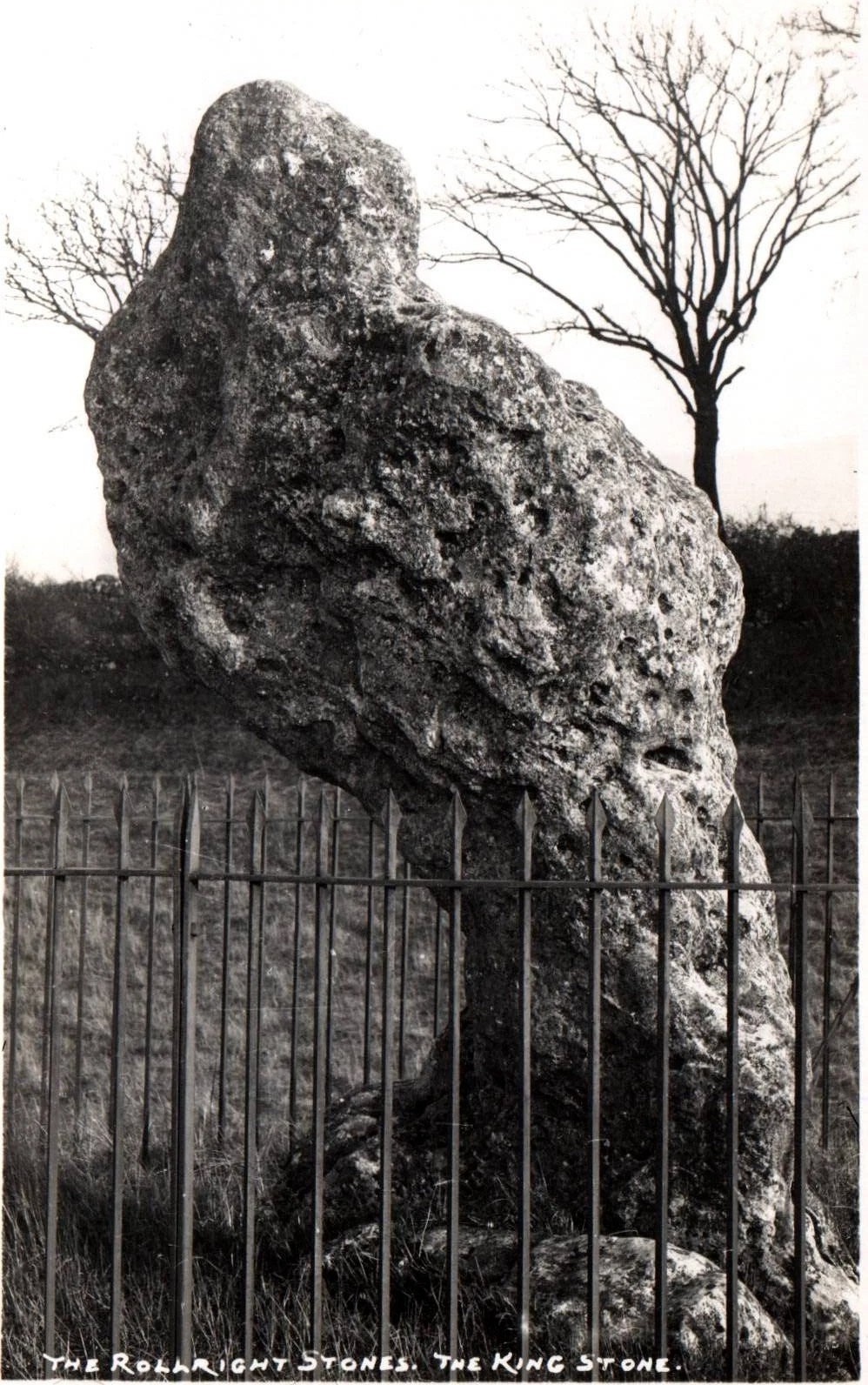
The old King c.1945King Stone, c.1920
“The Lord of the Manor of Little Rollright desired to possess the King’s Stone in order to bridge Little Rollright brook. So he dug it up and tried to cart it away, but found that he had not enough horses. He hitched on more, and yet more, and still he found that he could not move the stone. Finally he succeeded and hauled the stone away to the Manor House. The same night he was alarmed by strange sounds about the house, which he attributed to the presence of the King’s Stone, and decided, therefore, to replace it on its mound. No sooner had he harnessed the first horse to the cart than it galloped away up hill with ease, taking with it the stone, which leapt to position on reaching its resting place.”
Evans also wrote about an eighty-year-old local woman who told that her mother visited the King Stone on Midsummer’s Eve, along with many other locals, when the elder was in full bloom and they would stand in a full circle around the tall monolith. Ritual of a sort was performed then the elder tree was cut and, as it bled, “the King moved his head.” This annual rite was said to partially disempower the witch of her magickal hold over the King when her blood trickled from the tree. Some locals believed that if but a pin-prick of the witch’s blood was drawn, she would lose her power for all eternity.
Beneath both the Rollright stone circle and the King Stone, legend reputes there to be such a cavern where the little people live. In some accounts they are said to dance around the old King.
Arthur Evans told how one local man, Will Hughes, actually saw the faerie dancing round the King.
“They were little folk like girls to look at,” he said.
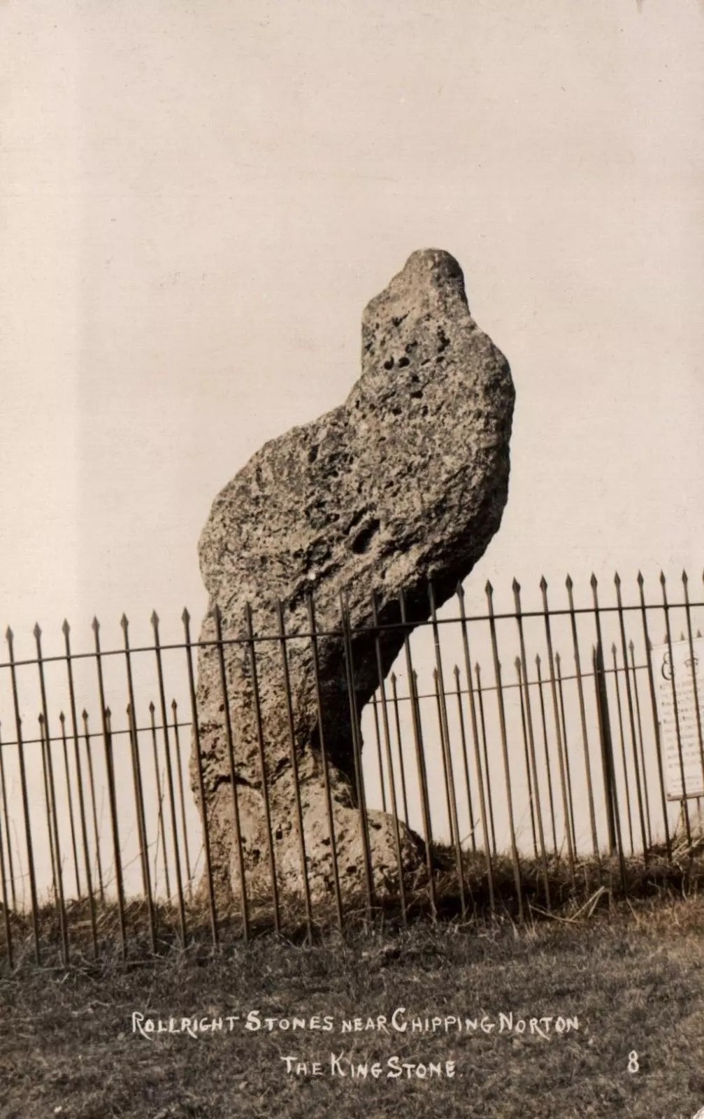
Old postcard, c.1910Sketch from 1904
Will’s widow, Betsy Hughes, told Evans that “when she was a girl and used to work in the hedgerows, she remembered a hole in the bank by the King Stone, from which it is said the fairies came out to dance at night. Many a time she and her playmates had placed a flat stone over the hole of an evening to keep the fairies in, but they always found it turned over next morning.” This curious entrance was a neolithic burial mound. Mark Turner described how the little people were “supposed to come out and dance around the stones by moonlight.”
As we have already seen, people used to take chippings off some of the old stones here—primarily the King—supposedly for luck, protection and good fortune. Local people used to blame Welsh workers more than anyone, but they wouldn’t be the only ones! Although those who took such chippings believed the pieces brought them luck, more often than not it was the opposite that happened. One local woman told Evans about her son who went to India as a soldier in the 19th century with a piece of the King Stone in his possession, but it did him no good whatsoever. He died of typhus! The Oxford archaeologist George Lambrick (1988) highlights in his book on the Rollright stones the extent of damage that has been done to the King Stone since 1607.
References:
Anonymous, The Rollright Stones: Theories and Legends, privately printed, n.d.
Bennett, Paul & Wilson, Tom, The Old Stones of Rollright and District, Cockley: London 1999.
Bloxham, Christine, Folklore of Oxfordshire, Tempus 2005.
Cowper, B.H., ‘Oxfordshire Legend in Stone,’ Notes & Queries (1st series), 7, January 15, 1853.
Devereux, Paul, ‘Is This the Image of the Earth Force?’ in The Ley Hunter 87, 1979.
Devereux, Paul, ‘Operation Merlin,’ in The Ley Hunter 88, 1980.
Devereux, Paul, ‘Operation Merlin 2,’ in The Ley Hunter 89, 1980.
Devereux, Paul, ‘The Third Merlin,’ in The Ley Hunter 92, 1981.
Devereux, Paul, Places of Power, Blandford: London 1990.
Devereux, Paul, The Sacred Place, Cassell: London 2000.
Evans, Arthur J., ‘The Rollright Stones,’ in Trans. Bristol & Glouc. Arch. Soc., 40, 1892.
Evans, Arthur J., ‘The Rollright Stones and their Folklore (3 parts),’ in Folklore Journal, 1895.
Lambrick, George, The Rollright Stones: The Archaeology and Folklore of the Stones and their Surroundings, Oxford Archaeology Review 1983. (Reprinted and updated in 1988.)
Michell, John, Megalithomania, Thames & Hudson: London 1982.
Pennick, Nigel & Devereux, Paul, Lines on the Landscape, Hale: London 1989.
Ravenhill, T.H., The Rollright Stones and the Men Who Erected Them, Little Rollright 1926.
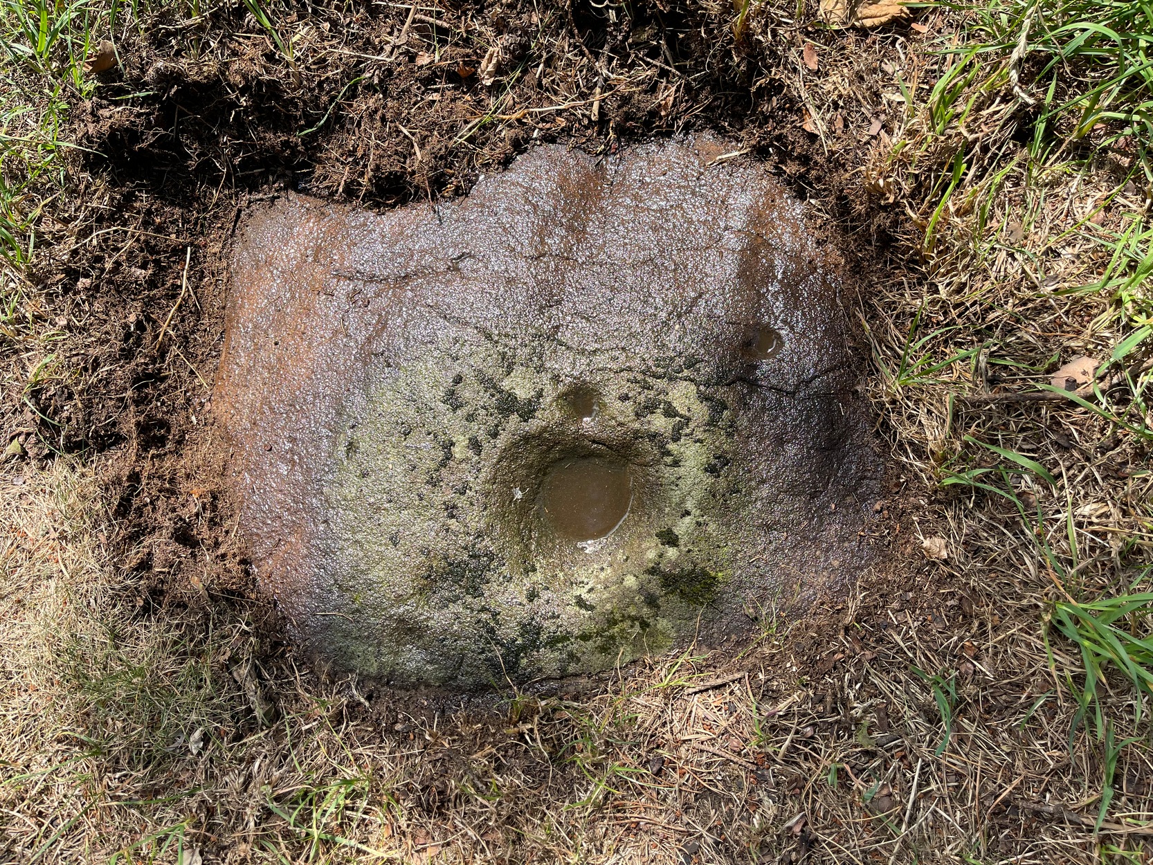
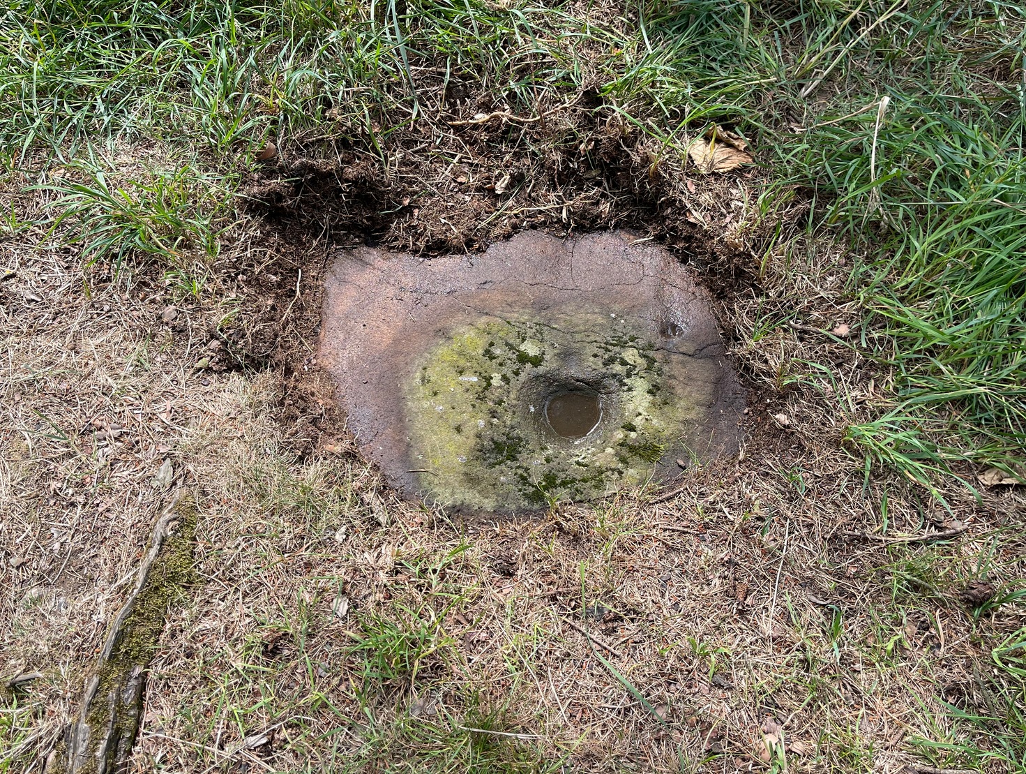
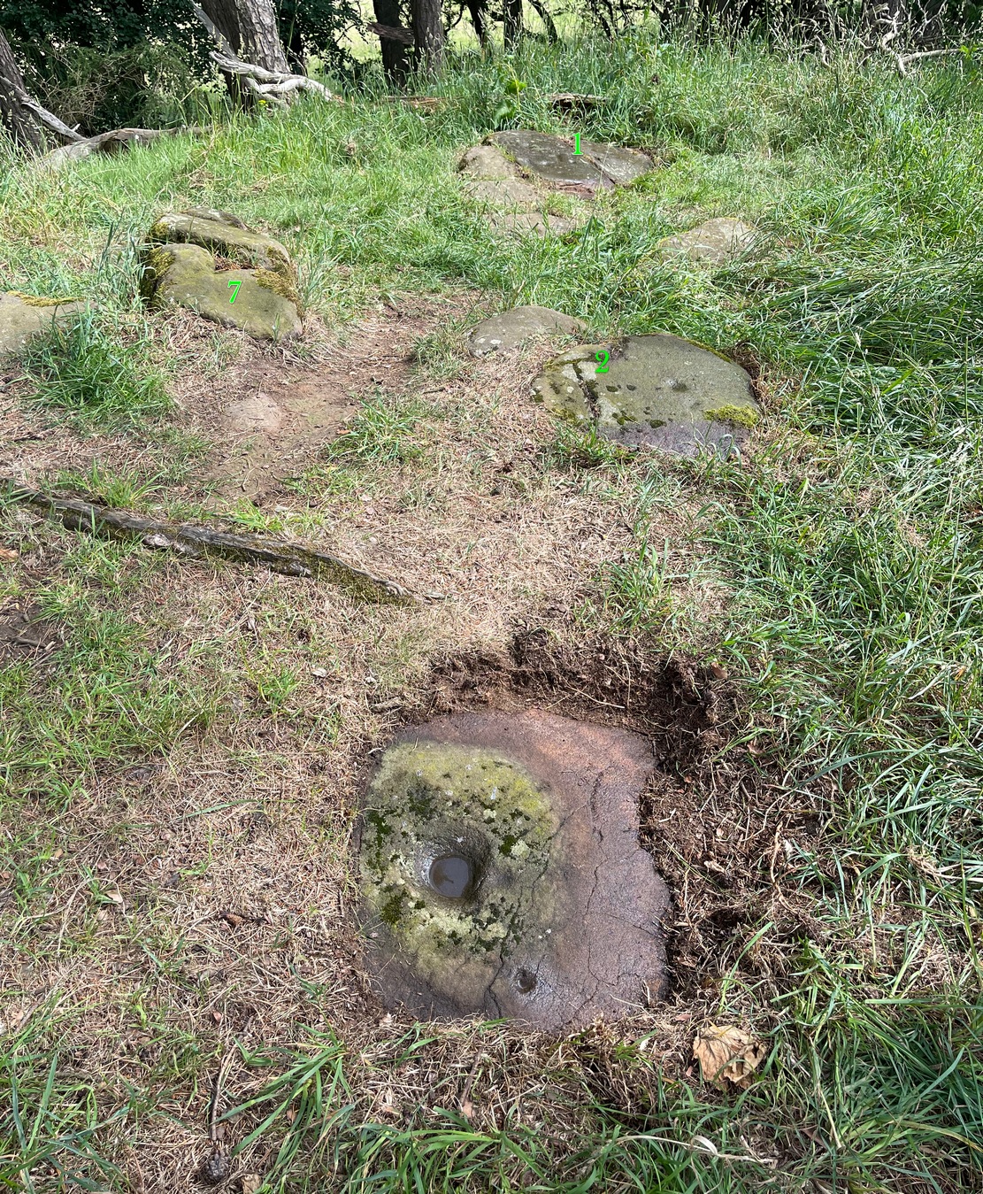
Found barely 12 inches east of the Tormain (7) carving, this ‘cup-marked stone’ is another somewhat dubious design in the Tormain cluster, but which I’m adding here for the sake of completeness. It’s designated as authentic by the Scottish Rock Art Project—but I’m not convinced. Consisting of just two cup-marks, Romilly Allen (1882) was the first to notice them and described them respectively as, “one 1 inch in diameter and the other 1½ inch across.” The smaller of the two, I’m pretty sure, is geophysical in nature.
Two or three yards from the impressive Tormain (1) carving you’ll see this elongated stone, cracked into three separate pieces. Its sloping southeastern section is possessed of a single cup-marking, an inch or two across, which, if you found it anywhere else, you’d just shrug your shoulders and walk on by. It’s only due to this stones proximity to the more impressive carvings that it’s received any attention (ordinarily I wouldn’t even have added this to the database). It was first noticed when Romilly Allen (1882) visited the area. The Royal Commission’s (1929) survey of Tormain Hill mentioned “a single cup on one boulder,” but didn’t specify which of the three examples up here they were referring to.
Royal Commission Ancient & Historical Monuments of Scotland, Inventory of Monuments and Constructions in the Counties of Midlothian and West Lothian, HMSO: Edinburgh 1929.
Follow the same directions to get to the Tormain (1) carving, but take a few steps backwards from it and it’s on a small flat earthfast stone to your right (west). You’ll see it.
Archaeology & History
Tormain bullaun stone
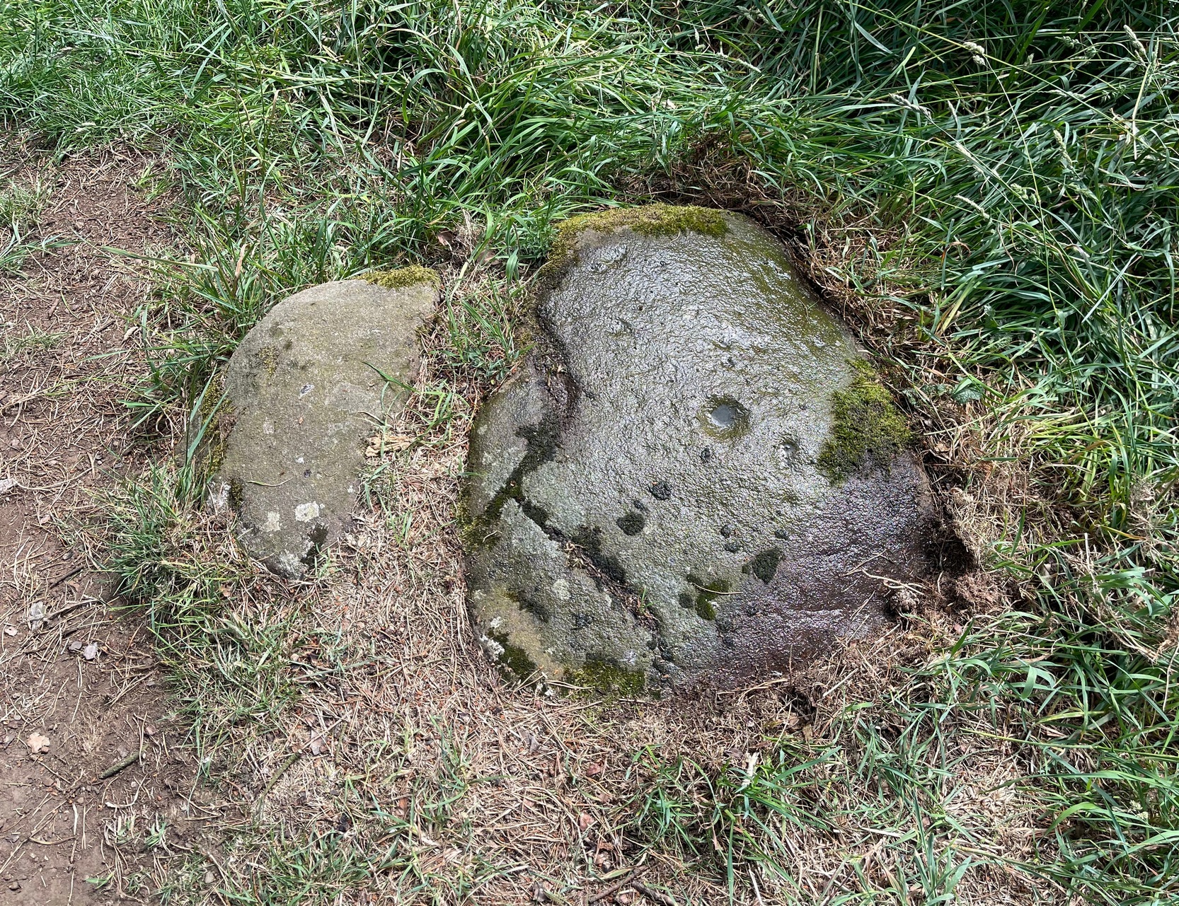
Just a stride or so away (north) from the dubious Tormain (2) cup-marking we find a much more likely prehistoric contender in front of us. It’s notably different from the others on the hill in that it possesses a very large wide and deep ‘cup mark’ which, if it was found in Ireland, would undoubtedly be classed as a bullaun stone. That was the first thing I exclaimed to myself when I clapped eyes on it! A bullaun can be a man-made or natural hollow or basin cut into outcropping rock, boulders or small portable stones and used for various pragmatic and ritual purposes – many with traditions and folklore attached. Sadly, no such folklore is remembered here.
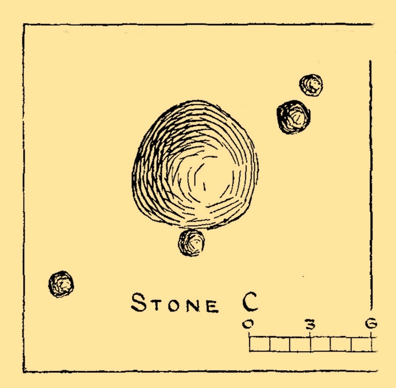
There are four other smaller standard sized cup-marks, at various distances from the primary bullaun, one of which may be Nature’s handiwork. They were illustrated by the great Romilly Allen (1882) when he first wrote about the carving. One of the cups may have a faint carved line running from it, but this would require the attention of the computer imagery dudes to confirm or deny this. It wasn’t seen by Allen, who simply said of it:
“The carvings on it consist of a bowl-shaped depression, 6 inches in diameter and 2 inches deep, and four cups near it varying in diameter from 1 to 1½ inches.”
Tormain 3 carvingTormain 3 (with 1, 2 & 7 marked)
The fact that bullauns possess a number of practical uses implies the large ‘bowl’ may have been used in a pragmatic sense for something, with the proximity of the impressive Tormain (1) carving just yards away almost appealing for ceremonial association of one form or another. We find similar bullaun/petroglyph associations at a number of other recognized rock art sites: the Mixing Stone in North Yorkshire being just one example. Large bowl-shaped hollows have been used in some cultures like mortar and pestles to macerate herbs, used in medicines and paints, both of which may have been applicable here.
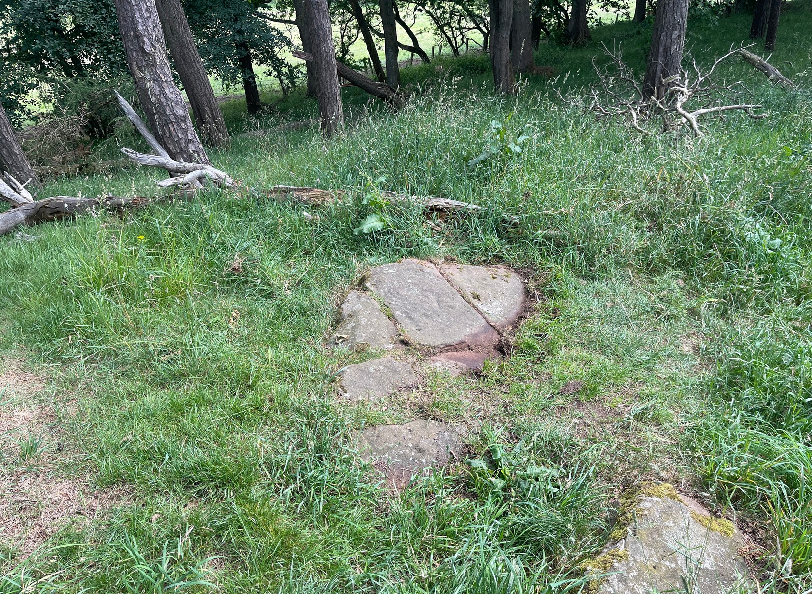
Best approached from Ratho village, head up Main Street towards Bonnington Mains. Shortly after the last road in the village (Halicroft Park, on the right) a small line of trees appears on the left and about 250 yards on a footpath takes you therein. Follow this for 250 yards (it runs parallel to the road) and the path then slopes uphill alongside the field. Go all the way to the top (roughly 500 yards) where the small copse of trees crowns the summit. On the ground there are a number of both small and medium-sized flat earthfast stones. You need to walk to the one at the end, just where the hill begins to slope back down. You’ll find it!
Archaeology & History
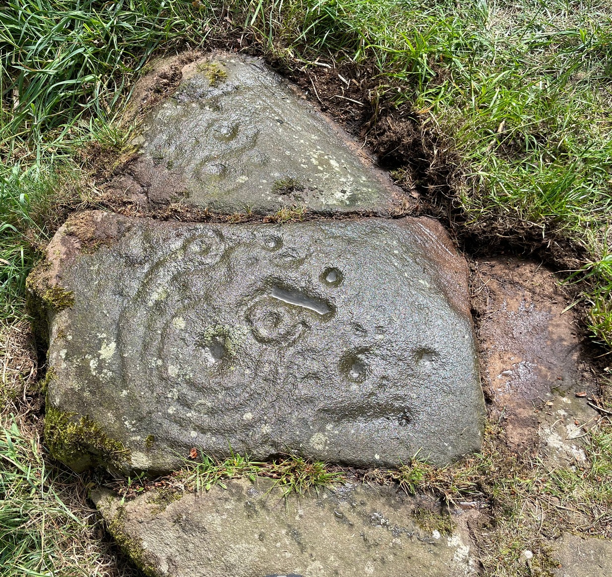
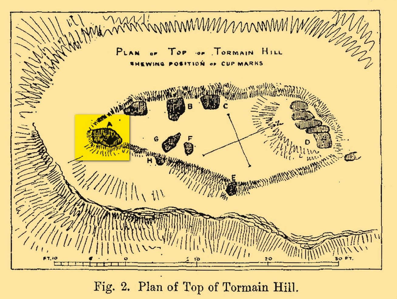
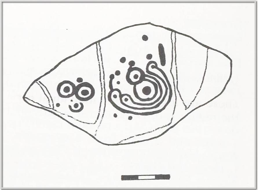
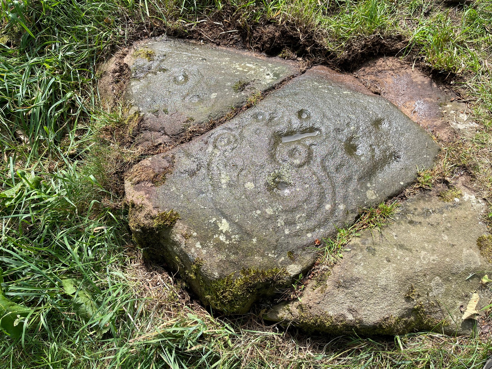
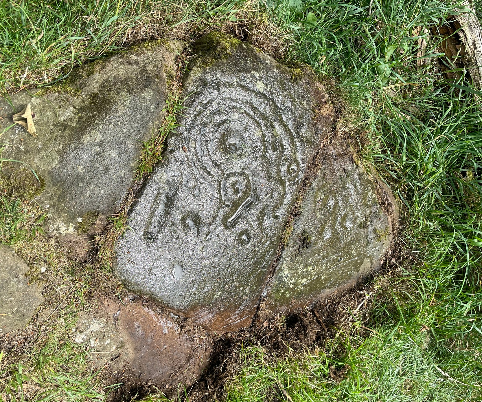
Tormain Hill, or the hill of stones (Harris 1996), has an interesting cluster of petroglyphs on its top, with this one in particular being the most impressive. It’s the southernmost stone in what’s been designated as a cluster of eight carvings—although we need to be slightly sceptical of one or two of them. Not this one though!
Regarded by Ron Morris (1981) as being “one of the best cup-and-ring designs in Scotland”, it was first mentioned by John Smith (1874) who visited the site with the local farmer James Melvin, who’d discovered the carving some years earlier. Initially he only noticed cup-markings, but when he visited the place with the pioneering rock art researcher Sir James Simpson, upon “removing the shallow soil or turf from the rock on the summit of Tormain Hill” this impressive multiple-ringed design came to light: “one cup (and) four concentric circles .”
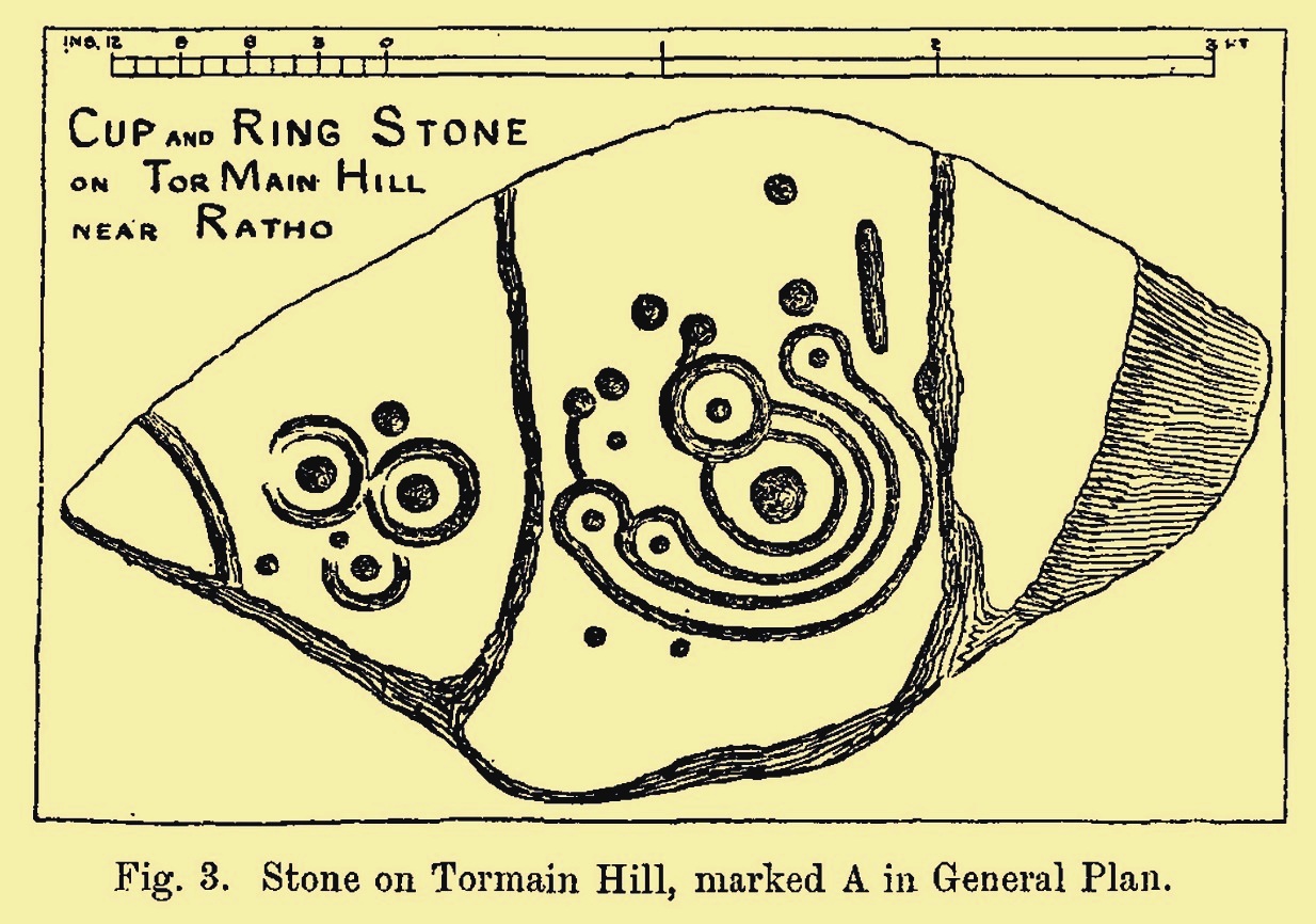
A few years later another rock art pioneer, J. Romilly Allen (1882) visited Tormain and found quite a bit more upon this hill. This particular carving, he told,
Allen’s 1882 sketchTormain ‘A’ site (Allen 1882)
“is much the finest and most remarkable in every way. It is the most southerly of the whole group, and is a piece of natural rock projecting from the side of the hill about 9 inches above the turf, and measures 4 feet 3 inches long by 2 feet 3 inches wide. Its upper surface is flat, of oval shape, and slopes slightly towards the hill. It is intersected by two parallel cracks of natural formation. The sculptures consist of twenty cups varying in diameter from three quarters of an inch to 2 inches in diameter. Seven of the cups are surrounded by a single ring, and one by four concentric circles. These latter are not complete, but form loops round terminal cups. Three of the cups with single rings are arranged in the form of a triangle. In addition to the cups and rings are two long grooves, one cutting off the corner of the stone, and the other parallel to one of the natural cracks.”
Beckensall’s 1986 version
More then forty years later the Royal Commission (1929) dudes visited the Tormain stones. It had become so overgrown by then that only two of the eight carved stones were visible: “but a search beneath the turf revealed the other sculpturings,” they told. It would seem that they chose a bit of a grey day when they came here as they told how the carving appeared “so much worn that the concentric rings are, in particular, difficult to follow.” So they did a rubbing of the stone—a common practice of rock art students over the last century or two. In doing so they were able to discern the following:
“The boulder is fractured in two places by natural agencies, but it shows traces of twenty cup-marks, varying from little more than half-an-inch to fully two inches in diameter, and there are two separate gutters. Seven at least of the cups are surrounded by single rings, and in two instances the rings are connected by shallow gutters to simple cup-marks. The largest cup-mark on the stone is encircled by one complete ring with three additional concentric arcs linking up four of the other rings. Another group consists of three cups, each surrounded by a ring, which are closely set in the form of a triangle, with three other smaller cup-marks in close proximity.”
Impressive stuff! In more recent times the site has gained the attention of fellow rock art explorers like Kaledon Naddair, Stan Beckensall and others—but we’re still none the wiser what it means!
Its position in the landscape was probably an important element. Pinus sylvestris (the ley-hunter’s favourite tree) grows spaciously, as it is wont, atop of the hill and, in bygone centuries, would have been much more prevalent before farming enveloped the land hereabouts. It was likely clear of trees on top of Tormain when the stone was carved, giving uninterrupted 360° views of the hills, high and low, as far as the eye can see. The legendary prehistoric Cairnpapple Hill stood out due west from the carving and other notable hilltops in the Pentlands would have had mythic relevance. Sadly, all oral tradition has long long faded and so whatever narratives that were told here have long ago been lost. It strikes me as a tribal gathering place: a moot hill perhaps. The bullaun stone adjacent to this fine carving would be a receptacle for paints, herbs, elixirs to be macerated and used by the people….
Check it out. Have a feel of the place. But spend a few hours here and listen to the wind…
Beckensall, Stan, Rock Carvings of Northern Britain, Shire: Princess Risborough 1986.
Beckensall, Stan, British Prehistoric Rock Art, Tempus: Stroud 1999.
Feachem, Richard, Guide to Prehistoric Scotland, Batsford 1977.
Hadingham Evan, Ancient Carvings in Britain: A Mystery, Garnstone: London 1974.
Harris, Stuart, The Place-Names of Edinburgh: Their Origins and History, Gordon Wright: Edinburgh 1996.
MacLean, Adam, The Standing Stones of the Lothians, Megalithic Research Publications: Edinburgh 1977.
Morris, Ronald W.B., “The Cup-and-Ring and Similar Early Sculptures of Scotland; Part 2 – The Rest of Scotland except Kintyre,” in Transactions of the Ancient Monuments Society, volume 16, 1969.
Morris, Ronald W.B., The Prehistoric Rock Art of Southern Scotland, BAR: Oxford 1981.
Royal Commission Ancient & Historical Monuments of Scotland, Inventory of Monuments and Constructions in the Counties of Midlothian and West Lothian, HMSO: Edinburgh 1929.
Found just a few strides away from the most impressive cup-and-ring stone at Tormain, is this quite un-impressive example and can easily be ignored. This simple cup-marked stone, first mentioned in Romilly Allen’s (1882) survey as “Stone B”,
“…lies 10 feet 3 inches to the north of stone A, and measures 4 feet by 2 feet 3 inches. It has a single cup cut on it.”
Tormain 2 “carving”Tormain 2 “carving”
Despite this being included in archaeological surveys as prehistoric, I’m unsure regarding the archaic authenticity of this single cup-mark and wonder whether it was just the result of idle dabblings by one of the quarrymen here in the 19th century. The lack of erosion leads me to suspect this. It has the appearance of cup-marks that have been carved by students at several different places in Britain (South Yorkshire, West Yorkshire, Perthshire, Renfrewshire, etc) over the last forty years. I’m quite happy to be wrong though! When the Royal Commission (1929) survey mentioned “a single cup on one boulder,” this may have been the one they were referring to.
Royal Commission Ancient & Historical Monuments of Scotland, Inventory of Monuments and Constructions in the Counties of Midlothian and West Lothian, HMSO: Edinburgh 1929.
Take the same directions as if you’re visiting the Tormain (1) carving (the best one of the bunch here), but about five yards before reaching it, to your immediate left, just at the edge of where the hill drops down slightly, you’ll see a small flat rock poking out of the ground that may have been cut and quarried at some time in the past. That’s the one!
Archaeology & History
This small compact design looks like a typical cup-marked stone with the usual scatter of cups in no seeming order—until, that is, you walk around it and look at it from different angles, whereupon you’ll notice that a couple of distinct deep carved lines have been cut in a cross formation, with cup-marks at the ends of the crucifix. My view of this is that cup-marks were done first, probably in the standard Bronze Age period, and the ‘cross’ was cut into the stone at a much later date, probably during the early christian era. The depth of the lines which create the ‘cross’ is deep and thin at the bottom, suggesting a metal tool, which seems to have been cut into an natural crack. Visitors here will notice a small drill-hole near the edge of the stone which seems to have been done by local quarrymen, probably in the 19th century.
It was first described in Romilly Allen’s (1882) article on the Tormain stones. He called it ‘Stone E’ and told that it
Location of Tormain 5Cups, lines & cross form
“is situated about half-way between stones A and D, and is furthest to the east. It measures 1 foot 4 inches by 1 foot 9 inches, and projects 1 foot above the turf. Its upper surface is flat, and on it are carved eight cups varying in diameter from 1 to 2½ inches. There are two connecting grooves between three of the cups, forming a rude cross. Another cup has a channel leading over the edge of the stone.”
In November 1927, the Royal Commission dudes visited the carving (and its companions), but they had to roll back the turf to see it clearly. On the stone they saw that “at least nine or ten cup-markings, in some cases with connecting gutters, are still more or less clearly outlined.”
Carving highlighted (Morris ’82)Ron Morris’s old photo
When Ron Morris (1981) visited here, he highlighted the carving in chalk to get a decent impression of the design, as the attached photo here shows. Many traditional cultures ritually paint their carvings at set times of the year, in traditions that go back many centuries—perhaps even millenia. In all probability the same thing was done at some of the British petroglyphs, although there are no remaining traditions. Anyhow, Morris described it succinctly as:
“½m square, ¼m high…on which are: eight cups up to 7cm (3 in) diameter and 4cm (1½ in) deep and some grooves, to of which connect some of the cups to form a well-defined Cross.”
The stone was looked at by the great rock art explorer Kaledon Naddair of Edinburgh, but sadly I’m unable to locate his report and the fine illustrations that always tended to accompany them. If you’re reading this sir, give us your valuable input!
Beckensall, Stan, Rock Carvings of Northern Britain, Shire: Princess Risborough 1986.
Beckensall, Stan, British Prehistoric Rock Art, Tempus: Stroud 1999.
Feachem, Richard, Guide to Prehistoric Scotland, Batsford 1977.
Hadingham Evan, Ancient Carvings in Britain: A Mystery, Garnstone: London 1974.
Morris, Ronald W.B., “The Cup-and-Ring and Similar Early Sculptures of Scotland; Part 2 – The Rest of Scotland except Kintyre,” in Transactions of the Ancient Monuments Society, volume 16, 1969.
Morris, Ronald W.B., The Prehistoric Rock Art of Southern Scotland, BAR: Oxford 1981.
Royal Commission Ancient & Historical Monuments of Scotland, Inventory of Monuments and Constructions in the Counties of Midlothian and West Lothian, HMSO: Edinburgh 1929.
Acknowledgements: Huge thanks to Jan Carrington for use of her photos. 🙂
Travel along the B867 road from Bankfoot to Dunkeld (running roughly parallel with the A9) and you’ll reach the hamlet of Waterloo about one mile north of Bankfoot. As you approach the far end of the village, keep your eyes peeled for the small turning on your left and head up there for just over a mile. The road runs to a dead end at Meikle Obney farm, but shortly before reaching there you’ll pass this large standing stone on the right-side of the road, just along the fence-line. It’s almost impossible to miss!
Archaeology & History
This is one of “the large rude upright stones found in the parish” that William Marshall (1880) mentioned briefly, amidst his quick sojourn into the Druidic history of Perthshire. It’s an impressive standing stone on the southern edges of the Obney Hills that doesn’t seem to be in its original position. And it’s another one that was lucky to survive, as solid metal staples were hammered into it more than a hundred years ago when it was incorporated into the fencing, much like the massive Kor Stone 6½ miles south-west of here.
Site shown on 1867 mapWitch’s Stone at roadside
Shown on the first Ordnance Survey map of the area in 1867, its bulky 6½-foot-tall body stands all alone on this relatively flat plain, with open views to the east, south and west. It gave me the distinct impression that it was once part of a larger megalithic complex, but I can find no additional evidence to substantiate this. Call it a gut-feeling if you will. Intriguingly, the closest site to this are two standing stones just out of view literally ⅔-mile (1.07km) to the northeast, aligned perfectly to the Witch’s Stone! Most odd…
Folklore
The story behind this old stone is a creation myth that we find all over the country, but usually relating to prehistoric tombs more than monoliths. The great Fred Coles (1908) wrote:
“the common legend is told of a witch who, when flying through the air on some Satanic behest, let the Stone fall out of her apron.”
Marshall, William, Historic Scenes in Perthshire, William Oliphant: Edinburgh 1880.
Stewart, Elizabeth, Dunkeld – An Ancient City, Munro Press: Perth 1926.
Acknowledgements:Huge thanks for use of the Ordnance Survey map in this site profile, reproduced with the kind permission of the National Library of Scotland.
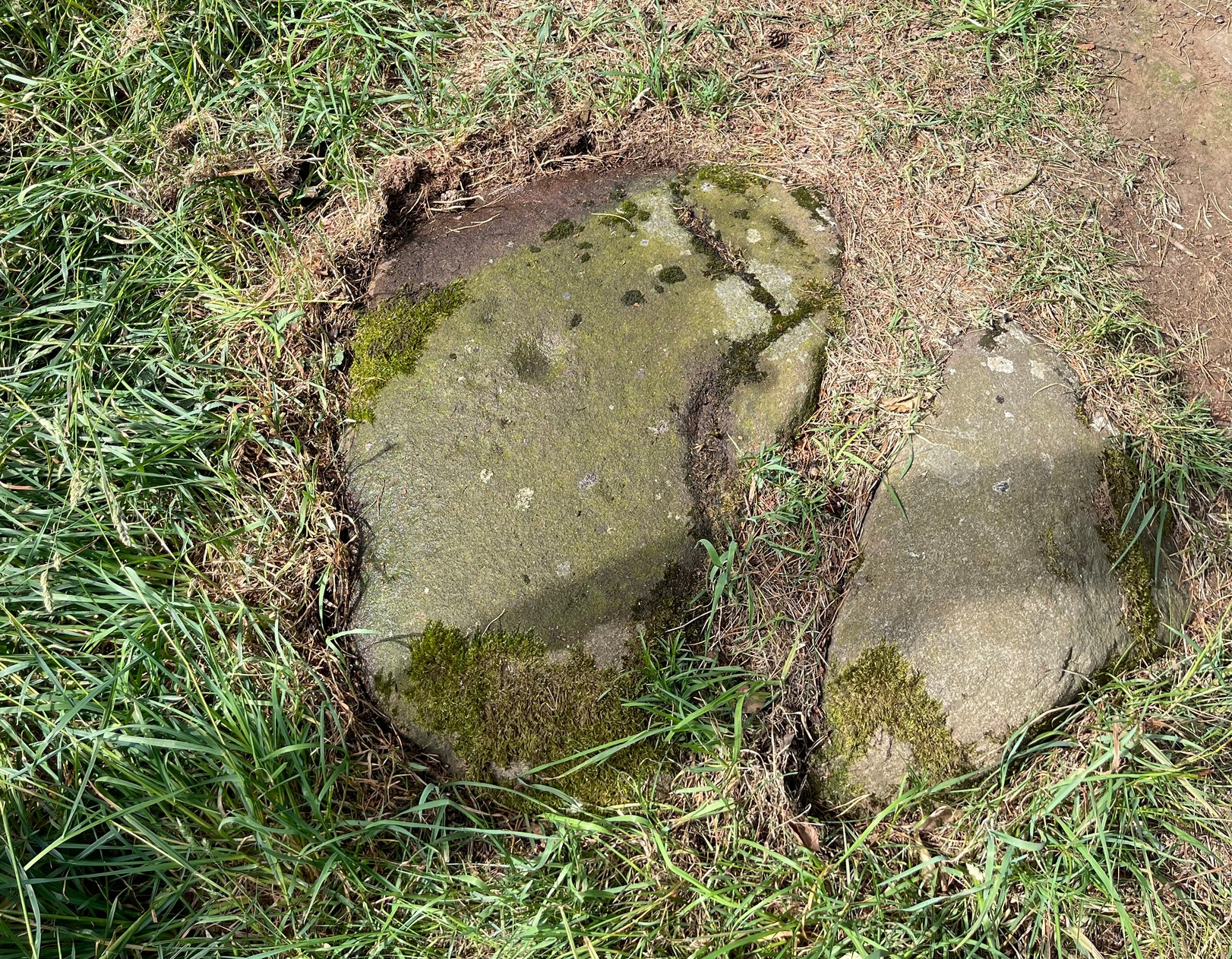
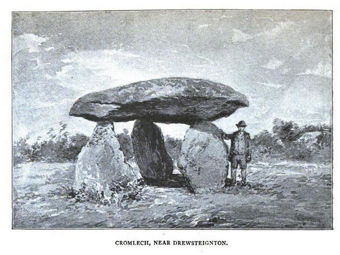
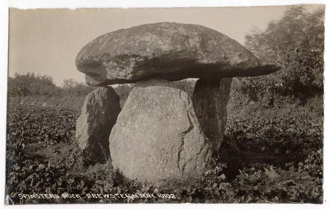
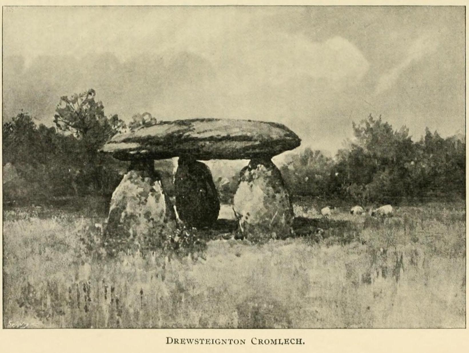
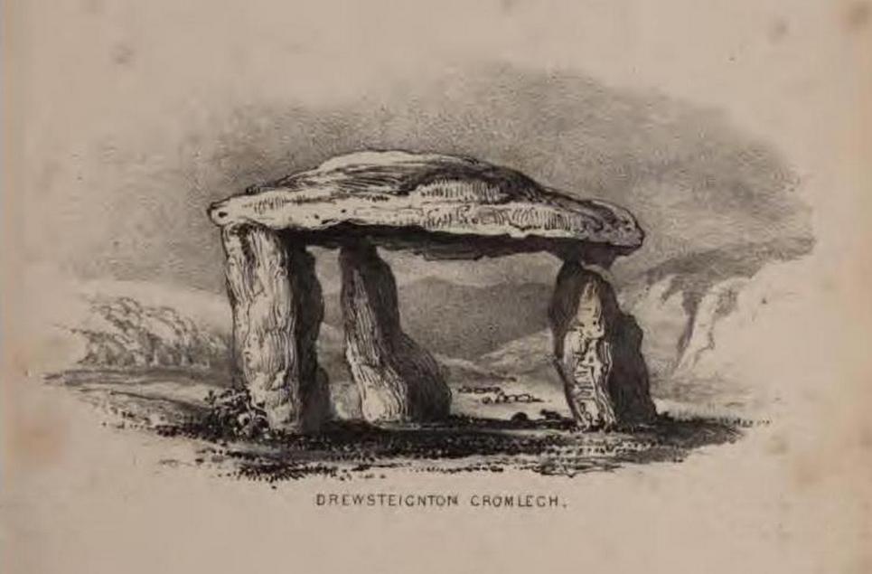
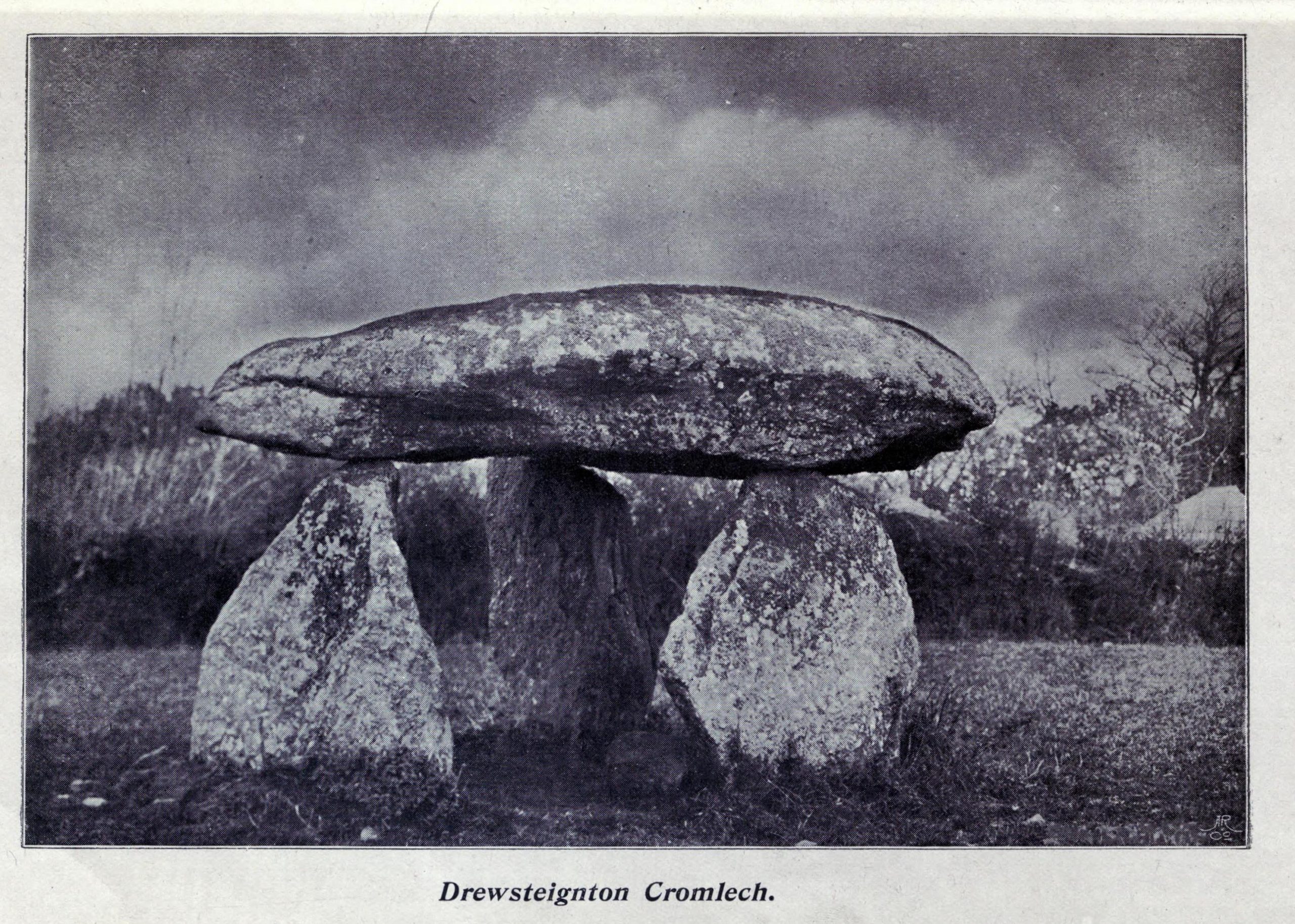
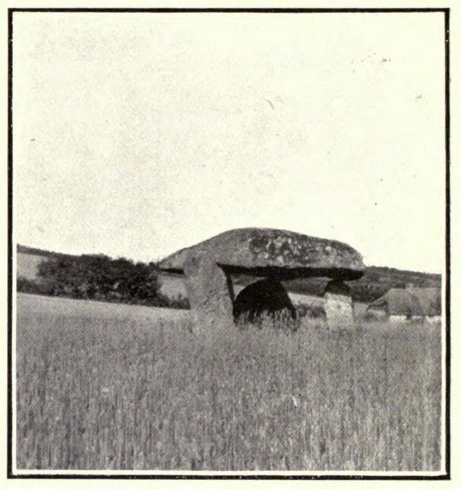
Highlighted on Benjamin Donn’s map of Devon in 1765, this impressive neolithic dolmen consists of three large granite support stones between 5 ft 7 in and 7 ft 7 in tall, surmounted by a large capstone measuring 15 feet by 10 feet. It collapsed in 1862 but was restored later the same year.
Folklore
In Murray’s (1851) Handbook for Travellers he told the following tale of the site:
This interesting old monument derives its name from a whimsical tradition that three spinsters (who were spinners) erected it one morning before breakfast; but “may we not,”* says Mr. Rowe (Peramb. of Dartmoor), “detect in this legend of the three fabulous spinners the terrible Valkyriur of the dark mythology of our Northern ancesters – the Fatal Sisters, the choosers of the slain, whose dread office was to ‘weave the warp and weave the woof of destiny.'”
Polwhele informs us that the legend varies, in that for the three spinsters some have substituted three young men and their father, who brought the stones from the highest part of Dartmoor; and in this phase of the legend has been traced an obscured tradition of Noah and his three sons.
.. The hill on which it stands commands an excellent view of Cawsand Beacon. About 100 yds. beyond the cromlech on the other (N.) side of the lane, is a pond of water, of about 3 acres, called Bradmere Pool, prettily situated in a wood. It is said to be unfathomable, and to remain full to the brim during the driest seasons, and some regard it as artificially formed and of high antiquity – in short a Druidical pool of lustration connected with the adjacent cromlech..
.. The country-people have a legend of a passage formed of large stones leading underground from Bradmere to the Teign, near the logan stone..
References:
Baring-Gould, Sabine, A Book of Dartmoor, London 1900.
Crossing, William, Gems in a Granite Setting, Western Morning News: Plymouth 1905.
Falcon, T.A., Dartmoor Illustrated, James G. Comin: Exeter 1900.
Murray, John, A Hand-book for Travellers in Devon & Cornwall, John Murray: London 1851.
Ormerod, G. Waring, Notes on Rude Stone Remains Situate on the Easterly Side of Dartmoor, privately printed 1873.
Page, John Lloyd Warden, An Exploration of Dartmoor and its Antiquities, Seeley: London 1892.
Worth, R. Hansford, Worth’s Dartmoor, David & Charles: Newton Abbot 1967.
Acknowledgements:Huge thanks for use of the Ordnance Survey map in this site profile, reproduced with the kind permission of the National Library of Scotland.
Holy Well (lost): OS Grid reference – SW 3550 2626
Archaeology & History
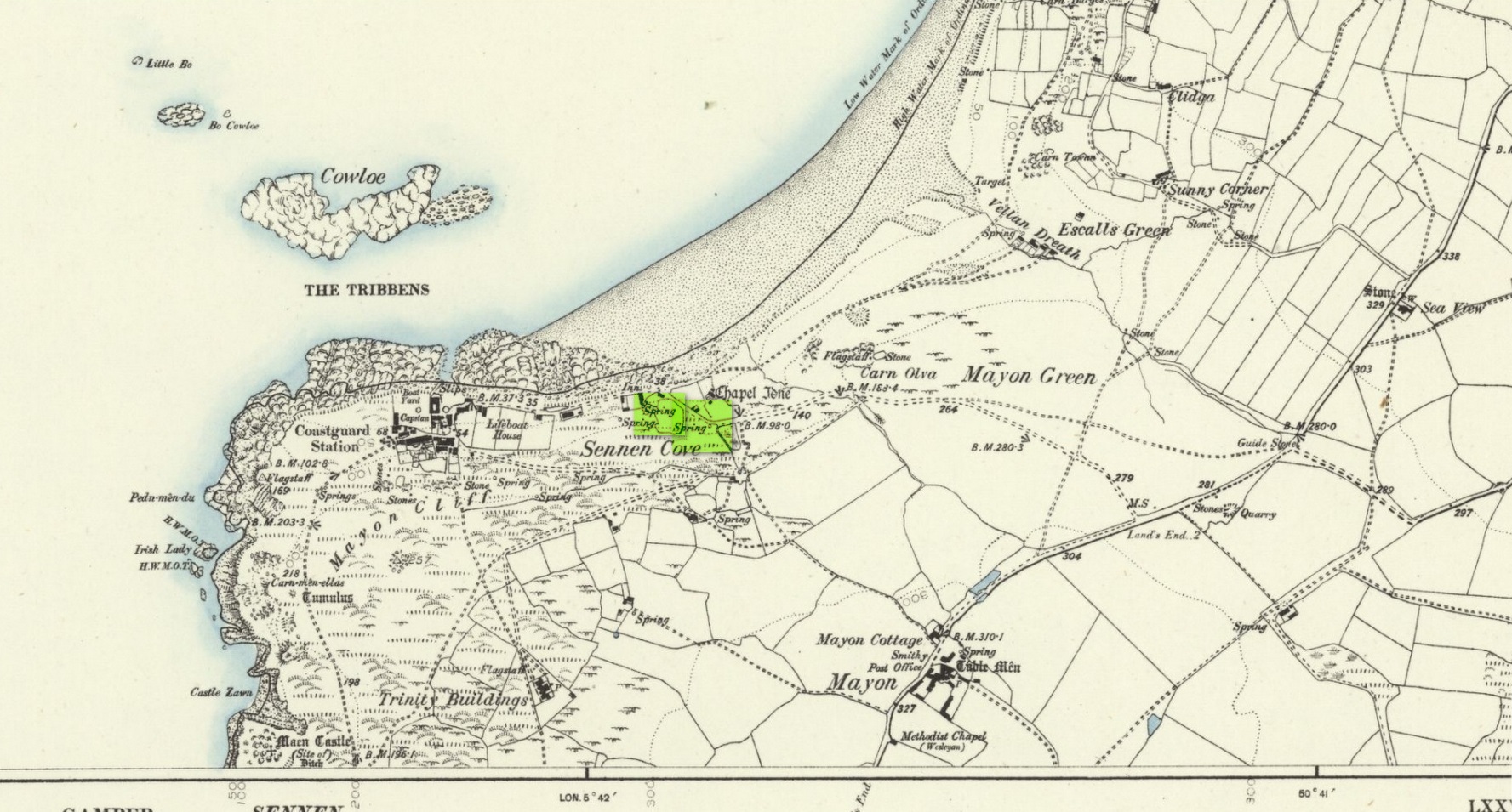
The springs of Chapel Idne
Highlighted on the 1888 Ordnance Survey map of Sennen Cove are the remains of Chapel Idne, just above the coast. Across the road from the chapel on its south-side, and also next to an old inn to its immediate west, springs of water are shown and it would seem more than likely that one of these two would have been the forgotten holy well of Sennen that was described, albeit briefly, in the great Mr Blight’s (1861) literary tour of the area. He told us that:
“At Sennen Cove was an ancient chapel, called by the people Chapel Idne, the “narrow chapel” being forty-five feet long and fifteen feet wide. It is now converted into a dwelling. Tradition says it was founded by one Lord of Goonhilly, who possessed dome portion of the land of Lyonesse. There was a holy well of some repute here also.”
The waters of St. Sennen’s Well were used in an act of ceremonial magick in the Arthurian tale known as the Battle of Vellan-druchar, as told in Robert Hunt’s (1865) great Romances. An attempted invasion by the Danes was met with by Arthur and nine other kings and the foreigners were slaughtered.
“A few had been left in charge of the ships, and as soon as they learned the fate of their brethren, they hastened to escape, hoping to return to their own northern land. A holy woman, whose name has not been preserved to us, “brought home a west wind” by emptying the Holy Well against the hill, and sweeping the church from the door to the altar. Thus they were prevented from escaping, and were all thrown by the force of a storm and the currents either on the rocky shore, or on the sands, where they were left high and dry. It happened on the occasion of an extraordinary spring-tide, which was yet increased by the wind, so that the ships lay high up on the rocks, or on the sands; and for years the birds built their nests in the masts and rigging.
Thus perished the last army of Danes who dared to land upon our western shores.
King Arthur and the nine kings pledged each other in the holy water from St Sennen’s Well, they returned thanks for their victory in St Sennen’s Chapel, and dined that day on the Table-men.
Merlin, the prophet, was amongst the host, and the feast being ended, he was seized with the prophetic afflatus, and in the hearing of all the host proclaimed–
“The northmen wild once more shall land,
And leave their bones on Escol’s sand.
The soil of Vellan-Druchar’s plain
Again shall take a sanguine stain;
And o’er the mill-wheel roll a flood
Of Danish mix’d with Cornish blood.
When thus the vanquish’d find no tomb,
Expect the dreadful day of doom.”
References:
Blight, J.T., A Week at the Land’s End, Longmans Green: London 1861.
Hunt, Robert, Popular Romances of the West of England, 1865.
Straffon, Cheryl, “Chapel Idne and the Holy Well,” in Meym Mamvro no.34, 1997.
Weatherhill, Craig, “A Guide to Holy Wells and Celebrated Springs in West Penwith,” in Meym Mamvro no.4, 1997.
Acknowledgements: Big thanks for use of the early edition OS-map in this site profile, Reproduced with the kind permission of the National Library of Scotland.