Parc-y Meirw, Llanychaer, Pembroke

Standing Stones:  OS Grid Reference – SM 9988 3591

Also Known as:

  1. Parc y Marw
  2. Parc y Meirw

Archaeology & History

Parc y Meirw - by Liz Haines
Parc y Meirw – by Liz Haines

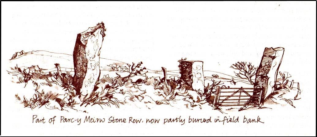
This is an impressive and well-known megalithic stone row, found just 4-5 miles inland from the coastal town of Fishguard.  The drawing here is used courtesy of Elizabeth Haines, landscape artist, and gives a fine representation of the site as I’m sure you’d agree!  Consisting of at least eight standing stones — four still upright and four laid down — aligning northwest to southeast, the tallest stone stands at the southerly end measuring 11 feet tall.  The stone row is found in a region rich in prehistoric remains.  Aubrey Burl (1993) said of the place:

“Four of the eight stones in this unusual row still stand, trapped in a  field-wall, tow of them now gateposts.  Thom suggested that the line, 131ft (40m) long, was laid out downhill towards the WNW and the minor northern moonset just north of Mount Leinster ninety-one miles away across the Irish Sea.”

Quite a distance!  And perhaps because of this, Burl thought that the nature of this line of stones was more archaeological than astronomical, with its focal point being more likely up the slope to the ESE instead.

Folklore

There was once an adjacent chambered tomb here which, when it was “destroyed for a house in 1844 brought the owner no luck” (Thom, Thom & Burl 1990) – which is damn good to hear!  There was a piece of folklore mentioned by E.L. Barnwell (1868) and other writers that the fields here marked the fall of three Welsh princes in the Battle of Mynydd Carn in 1084.  In Roger Worsley’s (1988) fine tour of Pembrokeshire’s historical sites, he tells how these megaliths in the “field of the dead” are also haunted, saying:

“A local tale tells of Ladi Wen, a ghostly White Lady wandering about the fields at night, and who will kill anyone who ventures near; it was enough to keep villagers away from the site well into this century, though the stone row is over five thousand years old.”

References:

  1. Barber, Chris & Williams, John Godfrey, The Ancient Stones of Wales, Blorenge: Abergavenny 1989.
  2. Barnwell, E.L., “Alignments in Wales,” in Archaeologia Cambrensis, volume 14, 1868.
  3. Burl, Aubrey, From Carnac to Callanish, Yale University Press 1993.
  4. Thom, Alexander, Thom, A.S. & Burl, Aubrey, Stone Rows and Standing Stones, BAR 560: Oxford 1990.
  5. Worsley, Roger, The Pembrokeshire Explorer, CCP: Abercastle 1988.

ACKNOWLEDGEMENTSA huge thanks to Elizabeth Haines, Landscape Artist, for use of her drawing of Parc-y Meirw.

© Paul Bennett, The Northern Antiquarian 


Penbont, Hundred House, Radnorshire

Standing Stone (destroyed):  OS Grid Reference – SO 117 544

Also Known as:

  1. Hundred House Standing Stone

Archaeology & History

Position of the old stone (on one of Alf’s leys)

In a field less than 200 yards north of an old medieval mound known as The Mount, the great ley-hunter Alfred Watkins (1925) described a standing stone that used to be here along one of his leys, but which, even then, had been “inexplicably blown into several pieces by a quarrymen’s charge.”

The stone was said to have originally come from an adjacent field and then moved next to yet another monolith, which was also broken up. Can any remnants of these poor fellas still to be seen anywhere nearby?  Or is it a case of yet another one bites the dust?

References:

  1. Watkins, Alfred, The Old Straight Track: Its Mounds, Beacons, Moats, Sites and Mark Stones, Methuen: London 1925.

© Paul Bennett, The Northern Antiquarian


Corwen Cross, Denbighshire

Cross & Cup-Marked Stone:  OS Grid Reference – SJ 0787 4340

Getting Here

Simple.  The church in the centre of the village across from the T-junction with the A5 is where it’s at!

Archaeology & History

Cross-base with cup-marks (from Owen, 1886)

At Corwen churchyard we find a number of curious old stone relics — not least of which is this seemingly 12th century christian cross, more than seven-feet tall, on the west side of the church. Not only does this have a curious history in itself, but the base on which the cross stands has what may be at least seven cup-markings etched on it.  These were first mentioned – I think – by Elias Owen in his Old Stone Crosses of the Vale of Clwyd, (1886) who wrote:

“The stone basement in which the (cross) shaft is placed is elliptical in form, with transverse and conjugate diameters measuring respectively 64 and 60 inches; it is 12 inches or so thick, is of a slaty nature and might have been procured in the neighbourhood… There are seven peculiar artificial depressions along the surface of the pedestal, strongly resembling the cup-markings which are found occasionally on the capstones of cromlechs, etc. They are irregularly arranged: on the north side there are three, almost in a line; and on other parts of the stone there are four of these marks. They differ somewhat from each other in size and shape, but they are for the most part circular, though one is more of an oblong than a circle. They vary also in depth, one being two-and-half inches deep, while the others are shallow. The largest is three inches in diameter; the others are not so broad.”

Owen makes note of a previous description of the Corwen “cross” by Thomas Pennant in 1784, where sounds as if this stone had a decidedly megalithic precursor. He told us:

“A most singular cross in the churchyard merits attention: the shaft is let into a flat stone, and that again is supported by four or five rude stones, as if the whole had been formed in imitation of, and in veneration of, the sacred Cromlech of very early times.”

Two other crosses are found at Corwen church – one of which has a decidely heathen legend attached to it. The Carreg y Big yn y Fach Rhewllyd monolith is also found here, in the porch wall.  A few miles east of here we also find another cup-marked stone, shown on The Old-Fashioned Antiquarian website.  Looks a good n’!

References:

  1. Owen, Elias, Old Stone Crosses of the Vale of Clwyd and Neighbouring Parishes, Bernard Quaritch: London & Oswestry 1886.

© Paul Bennett, The Northern Antiquarian


Upper Killay, Swansea, Glamorgan

Long Barrow (destroyed):  OS Grid Reference – SS 5848 9227

Also Known as:

  1. Cae Bryn-y-garn

Archaeology & History

Described in 1925 in a report by the Royal Institute of South Wales as “the remains of a long barrow,” it seems that all remains of this old site have been destroyed.  Where the long tomb once stood are now some bungalows (anyone know if they’re haunted!?).

The tomb was quite an impressive one from all accounts: aligning north-northeast, it was some 20 yards long and 10 yards wide (at its widest), standing between 6-8 feet tall.  When building operations started here in 1959, a disturbed mound of stones was noticed, but by 1965 the bungalows had been built where once rested the ancient dead.

The field-name to its immediate east — Cae Bryn-y-garn — tells us the old name of the cairn, as known to local folk.  Quite what its folklore may have been, I’ve yet to hear…

References:

  1. Royal Commission on the Ancient & Historical Monuments, Wales, An Inventory of the Ancient Monuments in Glamorgan – Volume 1, HMSO: Cardiff 1976.

© Paul Bennett, The Northern Antiquarian


Croes-llechau, Bronllys, Breconshire

Long Barrow (destroyed):  OS Grid Reference – SO 169 357

Also Known as:

  1. Croesllechau

Archaeology & History

It appears to have been Theophilus Jones who first mentioned this all-but-lost megalithic tomb, more than 200 years ago.  He told that,

“In a field called Croeslechau about two miles eastward of (Talgarth), but in the parish of Bronllys and on a farm called Bryn-y-groes, is a cromlech, not merely interesting on account of its antiquity, but from the circumstance of a white thorn growing close, and indeed under part of it, which has gradually raised the horizontal or covering-stone several inches out of its original position; it is therefore not only venerable as a relic of very ancient days, but as a natural curiosity.”

Croesllechau tomb in 1809

Thankfully he gave us the fine old drawing of the tomb, here reproduced.

Although shown on an 1832 map of the region, when Crawford (1925) came to describe this old tomb it had already been destroyed.  He told that,

“the site is unknown and all memory of it is has completely vanished in the neighbourhood. Mr Evan Morgan had visited the site and reports that no traces of the ‘cromlech’ were visible; nor were enquiries of the farmer at Bradwys any more successful in identifying the site.  It is not unlikely that the monument was destroyed when a new road was made…”

References:

  1. Crawford, O.G.S., The Long Barrows of the Cotswolds, John Bellows: Gloucester 1925.
  2. Jones, Theophilus, History of the County of Brecknock, volume 2, George North: London 1809.

© Paul Bennett, The Northern Antiquarian


Spread Eagle Cursus, Aberllynfi, Breconshire

Cursus Monument:  OS Grid Reference – SO 162 376

Archaeology & History

It seems that very little remains of this site, and there is some doubt over its authenticity.  Described in Alex Gibson’s (1999b) essay on the cursus monuments of Wales, he said this ‘cursus’ consists of,

“A cropmark of two parallel ditches orientated SE-NW, 15m apart and traceable for some 130m. It runs perpendicular to the present course of the River Wye 50m to the NE.  No terminals are visible, but there is a large ring ditch across the river 450m to the NW. A closely-grouped cluster of some 8 ring ditches is visible on a gravel terrace some 150m to the E,” but adds finally that “the identification of this site is suspect and may represent a fossil field system.”

The likelihood of the site being genuine seems to come from the “cluster of eight ring ditches on the gravel terrace some 150m to the east.”  Gibson (1999) also thinks how “the parallel ditches seem to be aligned on a ninth large ring-ditch 450m to the northwest and across the river.”  Ley-hunters have been scorned by archaeo’s for making such confounded comments!   The presence of a long cairn south of the cursus was also thought to add weight to the sites veracity.

Does anyone know what the present position on this site happens to be?

References:

  1. Gibson, Alex, The Walton Basin Project, CBA: York 1999.
  2. Gibson, Alex, ‘Cursus Monuments and Possible Cursus Monuments in Wales,’ in Barclay & Harding’s Pathways and Ceremonies, Oxbow: Oxford 1999b.

© Paul Bennett, The Northern Antiquarian


Sarn-y-Bryn-Caled, Belan, Montgomeryshire

Cursus:  OS grid reference – SJ 217 048

Also Known as:

  1. Welshpool Cursus

Archaeology & History

Much has been written about this ancient site.  Indeed, the archaeologist Alex Gibson (1999) told that, “the ritual complex at Sarn-y-bryn-caled has been extensively studied…and a development sequence based on relative and absolute chronologies, as well as site analogy, has been proposed.”  Created over a lengthy period spanning nearly 2000 years, Gibson (1999b) described this monument as a

“cropmark showing as two parallel ditches, 12m apart, running SW-NE for a distance of 370m. Causeways are visible through both side ditches. The terminals are not readily visible on the aerial photographs but have been proven with geophysical survey. The terminal ditches are straight and at right angles to the side ditches. Excavations proved the ditches to be 2m across at the gravel surface and c.0.8m deep. Charcoal from the base of the ditch provided a C14 date of 4960<>70BP. Silting patterns in both ditches and the raised profile of the gravel surface suggest external banks. Towards the NE end of the cursus is a cluster of circular ritual monuments comprising a large pit, timber circle, two ring ditches and a pennanular ring ditch. A possible second pennanular enclosure was located towards the SW end by geophysical survey.”

Less than 200 yards north of the northeast terminal is a second cursus-looking monument, ascribed in Gibson’s (1999b) survey as Sarn-y-bryn-caled II and which runs dead straight for 250 yards.  Although being nearly 40 foot across, Gibson thinks this long stretch is more likely to be the remains of an old trackway or road, telling that the very title — Sarn-y-bryn-caled — or “road by the hard hill”, may derive from this secondary linear feature.

Folklore anyone…?

References:

  1. Gibson, Alex & Simpson, Derek (eds.), Prehistoric Ritual and Religion, Sutton: Stroud 1998.
  2. Gibson, Alex, The Walton Basin Project, CBA: York 1999.
  3. Gibson, Alex, ‘Cursus Monuments and Possible Cursus Monuments in Wales,’ in Barclay & Harding’s Pathways and Ceremonies, Oxbow: Oxford 1999b.

© Paul Bennett, The Northern Antiquarian


The Whetstones, Churchstoke, Montgomeryshire

Stone Circle (destroyed):  OS Grid Reference – SO 303 976

Archaeology & History

Although geographically closer to the village of Priest Weston, this site — when still in existence — was in the parish of Churchstoke.  To be found a half-mile west of White Grit (near the famous Mitchell’s Fold megalithic ring and standing very close to the local boundary line), the Welsh Royal Commision report (1911) told that its position was, “at the foot of the northern slope of Corndon Hill, and close to a stile on the south side of the road near the turning to Cliffdale Mine.” Found close to a number of other prehistoric remains, the Report told:

“It is certain that at this place there once stood a circle of eight or nine stones.  An intelligent man, named John Jones, aged 74 years and a resident in the vicinity since his youth, remembers four stones arranged as though forming parts of a circle, with an appendage in a curve “like a hook.”  About 100 yards distant was a cairn, the foundation of which is still discernible.  The land was then unenclosed, but on its enclosure the cairn and the circle were rifled to provide stone for the construction of the existing fence.  Mr Jones pointed out the four stones which had been members of the circle.  The Rev. C. Hartshorne’s account of this circle in Salopia Antiqua, 1841, p.33, gives a slightly different account of the stones.  He observes, “these three stones (the Whetstones) were formerly placed upright though they now lean, owing to the soft and boggy nature of the soil.  The stand equidistant and assume a circcular position… The highest of these is four feet above the surface; 1 foot 6 inches in thickness; and 3 feet in width.”

When the Royal Commission lads got round to examining the remains here, they reported that,

“Only one stone is now to be found, embedded in the ground close to the stile entering the field, and this is so small that it is not likely to have formed one of the stones of the circle, or it must be a mere fragment of a larger mass.”

However, from the air, a very distinct circle is clearly visible, showing that something was here in bygone times.  In all likelihood, there’s gonna be something just beneath the surface here to tell us more about whatever once stood here.

References:

  1. Crawford, O.G.S., The Long Barrows of the Cotswolds, John Bellows: Gloucester 1925.
  2. Royal Commission on Ancient & Historical Monuments, Wales, County of Montgomery, HMSO: London 1911.

© Paul Bennett, The Northern Antiquarian


Maen Cattwg, Gelligaer, Glamorganshire

Cup-Marked Stone:  OS Grid Reference – ST 1269 9744

Also Known as:

  1. Gelli-Gaer carving
  2. Maen Catwg

Getting Here

From Gelligaer, take the northernern road up Heol Adam for 2-300 yards, where you’ll see a footpath on your left taking you into the fields. Walk up the path and as it crosses the wall and bends due east, you’ll see the boulder in the middle of the field. That’s it!

Archaeology & History

Across the road from Tir-y-Rhen is this singular flat boulder, measuring about 10ft x 6ft, with at least 33 full cup-markings etched on it. Described briefly in Chris Houlder’s (1974) Welsh Archaeological guide, then more recently in John Sharkey’s (2004) Welsh rock-art book where he told there to be perhaps another seventeen cups on its surface, the Royal Commission (1976) lads gave us the surity of definition in their survey of neolithic sites in the region. A kilometre north of Gelligaer, some 260m above sea level, we find this well-preserved carved rock:

“An approximately rectangular block…much weathered at at the corners…2.6m long NE-SW, by 1.7m wide, and about 0.6m thick.  The upper surface is covered with a haphazard series of 33 cup-marks varying from 40 to 115mm in diameter, and from 5 to 60mm deep… There are also 17 more cup-marks which are too weathered for precise measurement, but whose presence is certain.  Other may have been completely worn away.  Two more slabs of stone are just visible under the west corner of the main stone, suggesting the possibility that the cup-marks were made on the capstone of a cromlech, now collapsed.”

An earlier account by Wheeler (1925) described a number of lines or channels linking some cup-marks to each other, but these are now very difficult to see.  I’ll hopefully get some decent images of this carving sometime soon!

References:

  1. Houlder, Chris, Wales: An Archaeological Guide, Faber: London 1974.
  2. Royal Commission on the Ancient & Historical Monuments, Wales, An Inventory of the Ancient Monuments in Glamorgan – Volume 1: Pre-Norman, Part 1: The Stone and Bronze Ages, HMSO: Cardiff 1976.
  3. Sharkey, John, The Meeting of the Tracks, Gwas carreg gwalch: Llanwrst 2004.
  4. Wheeler, R.E.M., Prehistoric and Roman Wales, Oxford University Press 1925.

© Paul Bennett, The Northern Antiquarian


Llangynidr Bridge, Llangynidr, Breconshire

Standing Stone:  OS Grid Reference – SO 1562 2039

Also Known as:

  1. Gliffaes Stone
  2. Llywn y Fedwen

Getting Here

Not too difficult – and its size makes it pretty easy to spot!  About 100 yards across the river bridge from Llangynidr, there’s a small path heading into the trees by the riverside. Walk along it, or whichever way you find easiest to walk along the riverbank.  Then as you reach the third field along, look up into the hedgerow-cum-fence above you and you’ll notice the old stone sticking up!  Head for it!

Archaeology & History

A 14 foot tall standing stone with a most peculiar ‘modern’ history to it.  Some of you will like this, others may have palpitations – but… In recent times, since the notion of “energy at megaliths” have been in vogue, this was one of the first monoliths found to possess magnetic anomalies.  Described by the writer Francis Hitching (1976), he asked the Welsh dowser Bill Lewis to dowse at this stone and checked the results. Lewis dowsed a spiral of ‘energy’ rising up the stone as he did at many standing stones, and urged Hitching to see if he could bring his findings to the attention of any scientists.  So Hitching contacted the physicist professor John Taylor — he of Black Holes fame, of Kings College, London — who felt that Lewis’ dowsing finds were probably due to him sensing subtle changes in the magnetic field of the stone.  And so with this in mind, he sent a young Argentinian physicist called Eduardo Balanovski, armed with a gaussmeter, to see what they could find. As Hitching later wrote:

“What Balanovski found surprised him very much. After checking the background levels and setting the meter at zero, he pointed the measuring probe at the stone. The needle on the dial shot up, showing an anomaly far greater than the few thousandths or hundredths of a gauss that would have been normal…

“Balanovski has no doubt that the basic anomaly…is significant: ‘The point is that a water-diviner told us about it, and we went there and found something measurable. It may be the stone contains, geologically, the reason for the anomaly. Or it may be caused by something we don’t yet understand. But I do not personally believe that the stone was accidentally chosen or accidentally placed. The people who put it there knew about its power, even if they didn’t know about electromagnetism.'”

This initial finding brought Taylor himself to the place, where he, Balanovski and Lewis set to work.

“Lewis was filmed marking with chalk the places on the stone where he dowsed ‘energy nodes.’ When the gaussmeter probe was passed down the stone, it did register increases of magnetism at the marked points – there seemed to be ‘a very strong field on and around the stone, which seemed to fall in bands,’ as Hitching put it. It was a very impressive demonstration. Taylor urged caution, pointing out that much more work would need to be done to be sure of such reactions.”

Further work was eventually carried out by the Dragon Project, where no anomalous readings were found. Hmmm….

References:

  1. Devereux, Paul, Places of Power, Blandford: London 1990.
  2. Hitching, Francis, Earth Magic, Cassell: London 1976.

© Paul Bennett, The Northern Antiquarian