Brink Ends Cairn, Dovestones Moor, Wycoller, Lancashire

Cairn:  OS Grid Reference – SD 96138 42296

Getting Here

Best way to get up here is to start from the old hall and haunted bridge at Wycoller. From here walk upstream, on the footpath on the south side. It wibbles about following the waters for a half-mile until the moors open up when you reach an old stile, past which is another bridge over the stream. Walk past this (keep on the same side) for another 50 yards, then walk up the hillside where, if the vegetation is low, you can just see a decent-sized collection of rocks. This is the old cairn.

Archaeology & History

I don’t think the site is in the Lancashire archaeological register, but it’s described in John Bentley’s fine local history work, Portrait of Wycoller from 1975. He told that,

“a suspected Bronze Age burial mound at Brink Ends in Wycoller was excavated by Stanley Cookson in 1971 and 1972. Although no interment was discovered, the remains of a fire was found in the centre of the mound with half-burnt twigs and coal.”

Brink Ends Cairn, Wycoller

It’s not unlike some of the giant cairns on Ilkley Moor and elsewhere, though not as big, nor as high, being only about 22-24 feet across. Some of the stones have evidently been taken for use in the local walling, and the ‘cairn’ is in a pretty abject state. It’s a bittova odd spot to be honest. Not 100% sure what to make of it – though flints, arrowheads and similar implements have been found on the moors here close by. Bentley (1975) also told how “Stanley Cookson had strong suspicions that an Iron Age settlement existed in this area, but only time and further exploration will tell.” A sentiment I tend to agree with. And on our first and only visit here — during one helluvan awesome downpour all day — what seemed like an Iron Age hut circle was noted a few hundred yards to the south; though we got so saturated that day that we decided to turn for home soon after looking at this cairn.

Cookson and Hindle (1985) later described this site as a “middle Bronze Age burial cairn of 1400 to 900 BC, adding:

“The 34ft diameter inner circle was excavated during 1956-58 disclosing flints, a hearth with an abundance of charcoal, and four pieces of coal on a round, heavily burnt stone.”

More visits to these moors to check for other archaeological sites are needed in the near future to see what else might be on these unexplored moors.

References:

  1. Bentley, John, Portrait of Wycoller, Nelson Local History Society 1975.
  2. Cookson, Stanley & Hindle, Herbert, Wycoller Country Park, H.Hindle: Colne 1985.

© Paul Bennett, The Northern Antiquarian

Battle Hill Dolmen, Huntly, Aberdeenshire

Cairn (destroyed):  OS Grid Reference – NJ 542 401

Archaeology & History

In a short article, ‘Dolmens in Scotland’, written by Dr H.O. Forbes in the esteemed Antiquity journal of June 1929, Dr Forbes reported the former existence of a dolmen-like monument that stood,

“some 70 years ago…at the north or northwestern extremity of Battle Hill which looks down on the town of Huntly on the River Bogie in Aberdeenshire.  In walking from Drumblade to the town, about 3 miles off, one usually took a short cut over Battle Hill.  This bypath diverged from the turnpike road leading north to Banff and led to the top of Battle Hil (400ft), close past the edge of the wood, a few yards within which stood this monument.  It was a typical dolmen, of which I retain a perfectly clear recollection, with its large granite capstone supported by three massive, rudely shaped pillars.  On the aspect towards the bypath, there were some blocks of stone on the ground which may have constituted a fourth pillar or the ruins of a dromos, otherwise the dolmen was in excellent preservation.  It stood about 6 to 7 feet high above the ground level, for I remember it took some climbing for me as a small boy to get on top.”

Folklore

Dr Forbes also described several legends attached to this long forgotten old tomb.  He told “that it was a ruined druid’s altar; that the stones were dropped down through a hole in the devil’s apron when on his way to Knock Hill to deposit the cloven-stone there (a large glacial erratic); and that it is the tomb of a great warrior.”  A story that we find at a number of prehistoric tombs in both Britain and abroad.  At some nearby tumuli, legend told that they stood on the site of a great battle.

References:

  1. Forbes, H.O., ‘Dolmens in Scotland,’ in Antiquity journal, volume 3, June 1929.

  2. Grinsell, Leslie, Folklore of Prehistoric Sites in Britain, David & Charles: Newton Abbot 1976.

© Paul Bennett, The Northern Antiquarian 

Armshaw Lowe, Oxenhope, West Yorkshire

Tumulus?:  OS Grid Reference – SE 04422 35130

Getting Here

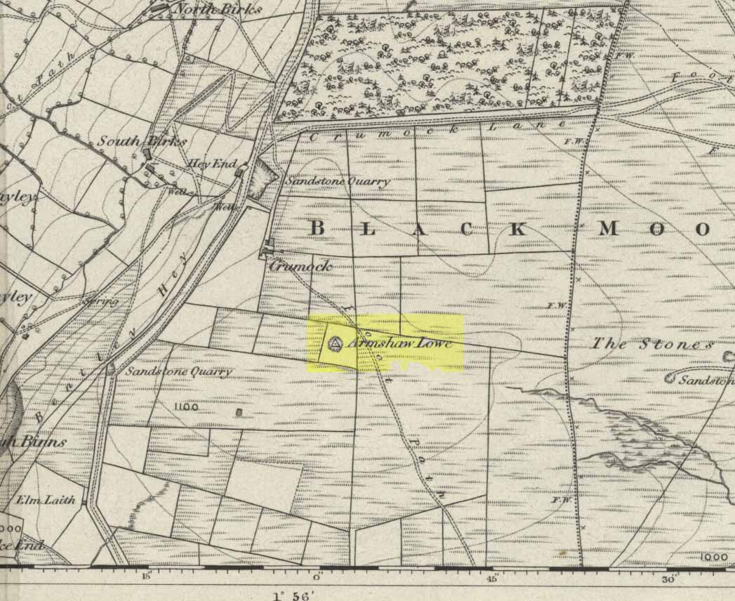
Armshaw Lowe on 1852 map

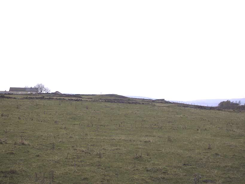
Go along the B6141 from Denholme to Oxenhope, turning right just by the bend which drops into Oxenhope, and head along the small road to Upwood Park camping site. Just before here is the Grange Park Animal sanctuary.  Ask there to walk onto the field behind, where you’ll see a rise in the land, as you can see on the rather poor photo I took from the east-side.

Archaeology & History

Although ascribed on early OS-maps as a tumulus (and still shown as an antiquity on the modern ones), this site appears to be simply the end-point along a geological ridge, starting a few hundred yards east of here, consisting of an upsurge of rocks covered in earth and nothing more. A survey of the place done by Bellamy in 1970 (Yorkshire Archaeological Journal, 42:6, 1970) seems to indicate the same. To those who want to test the theory, start by exploring it from Cullingworth Moor and walk along the ridge itself. It seems pretty clear.

Armshaw Lowe - looking west
Armshaw Lowe – the small mound in centre of photo

The “antiquarian” element to the site seems to originate in its positioning in the landscape. Armshaw Lowe is on the topmost point of the hills hereabouts, with 360-degree views all round, commanding excellent sights all round. But it’s perhaps the word ‘lowe’ that might be the important bit here, as in old english it can mean an old moot or meeting spot — which it may well have been for local tribes.  It is may be this element that gives Armshaw Lowe its lingering antiquarian status.

Check it out for yourselves and see what y’ think. I went up here to see an old burial mound, but found only a decent geological feature atop of local hills. But me ‘n’ the archaeologists might be wrong…

References:

  1. Gomme, G.L., Primitive Folk-Moots; or Open-Air Assemblies in Britain, Sampson Low: London 1880.

© Paul Bennett, The Northern Antiquarian

Brotton Howe, Brotton, Cleveland, North Yorkshire

Cairn (destroyed):  OS Grid Reference – NZ 6950 1886

Archaeology & History

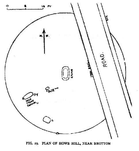
Frank Elgee’s 1930 plan

Another old site that has sadly succumbed to that bollox called ‘progress’! It’s in the North Yorkshire region some halfwits have taken to calling Cleveland — but which a lotta local folk still correctly call Yorkshire.  But that aside…

In an article by local students William Hornsby and Richard Stanton written in 1917, we find that this was just one of at least seven hillocks presumed to be barrows here — but all the others had gone even in their day.  When Crawford (1980) came to survey the site in the late 1970s, he told that,

“this large barrow is now only visible as a low swell in an arable field… (but) the profile of the barrow is retained in the hedgeline that bisects it from north to south, but the whole of its eastern half has been obliteratd by the Brotton-Kilton road.”

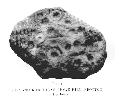
Elgee’s 1930 photo of one of the carvings
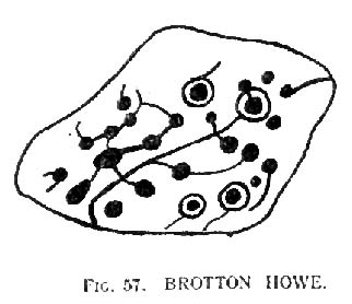
E.T. Cowling’s drawing of one of the carvings

When Hornsby and Stanton checked the place out it measured 54 feet in diameter and had an extensive covering of small stones, like a large cairn, with a single grave at the centre, aligned north-south; and a tree-trunk coffin on the southwestern side.  Of the stones which filled the central grave, eight of them were found to have cup-markings on them; whilst 16 stones covering the tree-trunk grave also possessed cup-markings. Roughly equidistant between the two burials was another stone found to be resting face-down on the original ground-level, and covered with 20 cups and 5 cup-and-rings!  Awesome stuff!

G.M. Crawford’s (1980) description of the site was as follows:

“Howe Hill was excavated by Hornsby and Stanton in 1914; they discovered that the mound was made up with a clay floor, overlain by ‘a cairn 30 feet long and 3 feet high’ of diorite cobbles, capped by a layer of earth. Cut into the clay floor were two graves: the first was oriented north-south and measured 2m long by 0.9m wide at the old land surface and was 0.7m deep. The grave was filled with ‘medium sized stones’ with a ‘thin dark layer,’ thought to be an inhumation burial, on the floor; 8 of the stones bore cup-marks. The second grave, oriented northeast-southwest, was 2.5m long by 0.9m wide at the old ground surface, reducing to 1.8m long by 0.5m wide at its bottom, 1.3m below. This grave, which was filled with stones, also contained a tree-trunk coffin or oak, measuring 1.5m long… At the head (northeast) were found the unburnt skull fragments of a man laid on its right side. Unaccompanied cremations had been placed at both ends of the coffin. 16 cup-marked stones were among the infill of the grave.”

This was obviously a site of considerable importance and it’s a huge pity (if not a disgrace) that today no trace of the site remains.

References:

  1. Cowling, Eric T., Rombald’s Way, William Walker: Otley 1946.
  2. Crawford, G.M., Bronze Age Burial Mounds in Cleveland, Cleveland County Council 1990.
  3. Elgee, Frank, Early Man in North-east Yorkshire, John Bellows: Gloucester 1930.
  4. Hornsby, William & Stanton, Richard, “British Barrows near Brotton,” in Yorkshire Archaeology Journal, 24, 1917.
  5. Smith, A.H., The Place-Names of the North Riding of Yorkshire, Cambridge University Press 1928.

© Paul Bennett, The Northern Antiquarian

Burwains, Foulridge, Lancashire

Cairn (destroyed):  OS Grid Reference – SD 888 421

Archaeology & History

Burwains on the 1848 map

The place-name burwain is an early Old English word meaning “a cairn or tumulus”.  It has variants such as borrans, borwen and borwans.  In the developing survey by Parsons & Styles (2000), other linguistic examples are given, all of which point to the same thing, i.e., a prehistoric burial of one form or another.  Also, in 19th century northern English dialect, Wright (1898) told that borrans is “a cairn, a heap of loose stones”—which is what used to exist hereby.

The fact that there is a place-name telling of its existence implies that it was a cairn of some size, but sadly all remains of it have long since gone.  All that we’ve got left is the name of Burwains house on the early Ordnance Survey maps.  Built on a hilltop rise, which is a common construction spot for such sites up and down the country, it’s possible that the cairn was destroyed when the Foulridge Lower Reservoir was built in 1793, with the mass of stone used in its construction (the reservoir also kept the name of Burwains lake for sometime).

References:

  1. Clayton, John A., Valley of the Drawn Sword, Barrowford Press 2006.
  2. Parsons, D.N. & Styles, T., Vocabulary of English Place-Names – volume 2, EPNS: Nottingham 2000.
  3. Smith, A.H., English Place-Name Elements – volume 1, Cambridge University Press 1954.
  4. Wright, Joseph, English Dialect Dictionary – volume 1, Henry Frowde: London 1898.

© Paul Bennett, The Northern Antiquarian