Chambered Cairn (destroyed): OS Grid Reference – NS 58 76
Also Known as:
Blochairn 2
Canmore ID 44421
STR 3 (Henshall)
Archaeology & History
Close to the ruined Craigmaddie Muir cairn could once have seen a companion, of roughly the same size and structure and made up of thousands of small stones, covering a long internal chamber. It was described in David Ure’s (1793) early history work on the area which, even then, thanks to “frequent dilapidations, will soon be annihilated.” The cairn was included in A.S. Henshall’s (1972) magnum opus in which she wrote:
“There was a second cairn in the vicinty of Craigmaddie Muir I. It was also ‘of an elliptical shape.’ Writing in 1793, Ure says that it ‘was laid open last year, and, though not so large as the other, was of the same construction, which seems to be Danish. Some of the stones placed in the rows at the bottom are considerably large… Among the contents, upon opening…were urns… One of the fragments of an urn is ornamented, near the mouth, with two shallow grooves. The diameter of the circle of which it is a segment seems to have been at least 20in.”
Fragments of human bones were also found within the site, but the entire cairn was sadly destroyed a long time ago. In the Stirlingshire Royal Commission report (1963:1) it was speculated that the urn found herein,
“must have been either a neolithic vessel or a cinerary urn. In view of the method of construction of the chamber it may be assumed that both cairns were related to the Arran or Clyde-Carlingford types.”
References:
Henshall, Audrey Shore, The Chambered Tombs of Scotland – volume 2, Edinburgh University Press 1972.
Royal Commission on the Ancient & Historical Monuments, Scotland, Stirlingshire – volume 1, HMSO: Edinburgh 1963.
Ure, David, The History of Rutherglen and East Kilbride, Glasgow 1793.
Balbirnie stone circle – with Marion checking it out!
Take the A92 road running north out of Glenrothes towards Freuchie and, after a couple of miles out of town, you’ll hit the B969 road on your left. Across from here on the other side of the road, you’ve just passed a small B-road that takes you to Markinch. That’s where you need to be! Go along there for less than 100 yards and turn first right, swerving along the tree-lined road for 200 yards or so. Watch out, just before the first house on your left, for a footpath which leads into the woods. Walk down it, barely 10 yards!
Archaeology & History
This is a lovely megalithic ring in a lovely setting – albeit a new one. The circle was originally positioned some 125 yards northwest of here and would have been destroyed, but was thankfully reconstructed by Fife Council before road-widening of the A92 was done. And the job’s a good one! But as Burl (2005) tells, this wasn’t the first time Balbirnie had been threatened with damage:
The southeast stones & cistsBalbirnie from the roadside, looking SE
“With some stones removed in the eighteenth century, dug into in 1883 when bones and sherds were found, damaged by trees, it was finally excavated and restored in 1970-71,” before the main road was built. Thankfully it’s still here – and an excellent stone circle it is! However, the reconstructed site here doesn’t show the circle in its entirety. Originally there were ten standing stones making up the ring, as opposed to the seven you can see today.
The site was built amidst the scatter of other larger, and once more impressive, mythically important monuments than the circle – but it’s as likely that the circle added more to the sacred dimensions of the region as a whole when it first came to be built. For on the other side of the A92 we can still see the denuded remains of the Balfarg Riding School Henge, with imitations of its internal upright posts resurrected into position to give an idea of what once stood inside the sacred enclosure. And then about 200 yards west of that, the gigantic Balfarg Henge is impressively surrounded by a modern housing estate, built with the henge in mind, with its outlying megaliths and internal level surface area graciously intact. It’s a truly impressive prehistoric area all round, although the Balbirnie stone circle was built some considerable time after the two henges had been done, many centuries later…
Before the circle was moved, the consensus profile of the site was that given by the Royal Commission (1933) lads following their visit here in June 1925, when they told it looked like this:
Royal Commission ground-plan, c.1933
“At the southern end of a small wood on the east side of the main road from Kirkcaldy to Falkland, about 180 yards south of Balbirnie Lodge, are the remains of a large circular cairn and of the setting of standing stones by which it was once surrounded… The circle, which has had a diameter of some 48 feet, has been composed of sandstone boulders. Four of these are still in place, but one other on the southeast has been slightly displaced, while against the stone on the northeast lie two large boulders, which apparently have been transferred to this position. Any other stones that may once have existed have been removed or destroyed. The greatest height above ground of any of those that survive is 5 feet 6 inches, while one, which rises no more than 2 feet, measures in circumference as much as 9 feet 9 inches at the base. The cairn itself seems to have been broken into at two points. No record of these excavations appears to be extant, but a number of fragments of cinerary urns from the site are preserved in the National Museum. These indicate that, as might have been inferred from its general character, the monument was sepulchral and dates from the Bronze Age.”
Sepulchral indeed. When the stone circle was excavated at the beginning of the 1970s by J.N.G. Ritchie (1974) and his mates, it was discovered this was a primary function of the site. As Burl (2000) wrote:
“At Balbirnie patches of cremated bone lay underneath some circle-stones. Whatever the ceremonies here they were interrupted when the site was converted into a cemetery. Four or five cists associated with a late beaker and a jet button were constructed within the ring. The date of about 1650 BC came from wood alongside the beaker. Stretches of low walling were put up between the stones forming a continuous barrier…analogous to the embanked stone circles elsewhere in Britain that seem generally to belong to a period in the mid-second millennium… But the first cists did not long remain undisturbed and were seemingly rifled when later cists were built that contained the cremations of women and children… One of these later cists held a food-vessel and a flint knife.
“The stone circle was further abused. A low cairn was piled over all the cists. Sherds of deliberately broken urns, one with barley impressions, were scattered amongst the boulders, intermingled with small coagulations of burnt human bone. This last phase at Balbirnie occurred late in the second millennium BC, for a C-14 determination of…1200 to 900 BC came from the land surface that had built up within the ring during the centuries while the stone circle remained open to the weather.”
Measuring 49 feet across at the widest, this flattened ellipse also possessed a curious rectangular section of laid stone, near the middle of this circle, almost ‘Roman-road’ like in appearance and covering about a quarter of the internal arena. It’s visible today at the reconstructed site and looks almost intrusive! Measuring some 11 feet by 9 feet, the flat stone surface has been suggested as a place where corpses were rested.
Also found within two of the tombs inside the circle were the cup-and-ring marked stones of Balbirnie 1 and Balbirnie 2, showing yet again the relationship that some of these carvings have with spirits of the dead.
References:
Burl, Aubrey, “Intimations of Numeracy in the Neolithic and Bronze Age Societies of the British Isles (c.3200-1200 BC),” in Archaeological Journal, volume 133, 1976.
Burl, Aubrey, Rings of Stone, BCA: London 1979.
Burl, Aubrey, The Stone Circles of Britain, Ireland and Brittany, Yale University Press 2000.
Burl, Aubrey, A Guide to the Stone Circles of Britain, Ireland and Brittany, Yale University Press 2005.
Denston, C.B., “The Cremated Remains from Balbirnie, Fife,” in Archaeological Journal, volume 131, 1974.
Ritchie, J.N.G., “Excavation of the Stone Circle and Cairn at Balbirnie, Fife,” in Archaeological Journal, volume 131, 1974.
Royal Commission on the Ancient & Historical Monuments, Scotland, Inventory of Monuments and Constructions in the Counties of Fife, Kinross and Clackmannan, HMSO: Edinburgh 1933.
Acknowledgements: Huge thanks to Marion Woolley for getting us out to see this and the related neolithic monuments. Cheers m’ dears!
Take the same directions as if you’re going to Dave’s Stone, to the eastern end of Rivock Edge itself. Then take less than 10 steps further onto the moor itself and you’ll see the stone pretty low down in the heather. (please note that grid-reference above needs revising)
Archaeology & History
…and looking straight down!
Found about 10 yards onto the flat ridge south of Dave’s Stone cup-marked stone, the vegetation covering this carving had only recently been brushed off when we revisited the place in 2012, by members of the Ilkley CSI team in their own survey of the area. As you can see, it’s a simple design of just two well-preserved cups on a small rounded stone. What may be the remains of a very faint ring arc is possible over one of the two cups. Nowt much more to say really!
From Blackford on the north side of the A9, cross over and take the small B-road which quietly runs up and over Sheriffmuir towards Dunblane. After a mile, keep your eyes keen for the approaching woodland on your right-hand side; for in the field just before the woods, you’ll see a patch of grass near the corner of the field with a long stone poking out of it. That’s it!
Archaeology & History
It seems that very little has been written about this monolith in any of the archaeology texts, but it’s ascribed locally to be a fallen standing stone. The site’s described in Finlayson’s (2010) fine local megalith guide where he points out how it’s in line with other nearby standing stones at Gleneagles and the White Stone – and the line is damn close!
…and from another angle…
With a quartz vein running through it, the stone lays some thirteen feet long and was, at some time in the not-too-distant past, readied to be quarried, as evidenced by the chisel-marks cut into it, prior to the usual destruction. But this time, for some reason, someone must have come to the rescue and prevented its demise…thankfully…
The farmer annually cuts around the fallen stone, shaped like a long boat (hence the name), near the top corner of the field. It would have looked damn good when stood upright, standing about ten feet in height and visible for a good distance. But today it’s quite forlorn laid here, seemingly alone, in this quiet part of the country, and is probably only one of interest to hardcore megalithomaniacs amongst you!
References:
Finlayson, Andrew, The Stones of Strathearn, One Tree Island: Comrie 2010.
From Cow & Calf Hotel head onto the moor above you, following the same directions to reach the ornately carved Idol Stone (and its immediate companions). Ahead of you on the same footpath, about 100 yards along, as it begins to slope up the hill further onto the moor, you’ll see a large upright pyramid-shaped stone, about 8 feet all, right at the side of the path. Y’ can’t miss it!
Archaeology & History
Deep cups & lines on top
Although ascribed as a cup-marked stone in usual surveys, the cup-markings on top of this rock are seemingly Nature’s handiwork. There is a possibility that cup-markings were carved into the top of the stone, many thousands of years ago, but due to the centuries of wind and weathering, we cannot in anyway assess the curvaceous bowls and lines running across and from the top of this rock to be artificial.
Folklore
The name ‘Idol Stone’ seems to have come about as a result of the judaeo-christian Victorian obsession of satanic idolatry in all things natural – which many of them still fear. Sadly there are no early accounts of practices of idolatry at this rock, until it was used by chaos magickians in the formative years of that Current in the 1980s.
References:
Bennett, Paul, The Old Stones of Elmet, Capall Bann: Milverton 2001.
Boughey, K.J.S. & Vickerman, E.A., Prehistoric Rock Art of the West Riding, WYAS: Leeds 2003.
Forrest, C. & Grainge, William, A Ramble on Rumbald’s Moor, among the Dwellings, Cairns and Circles of the Ancient Britons, W.T. Lamb: Wakefield 1868-9.
Hedges, John (ed), The Carved Rocks on Rombald’s Moor, WYMCC: Wakefield 1986.
Holmes, J., “A Sketch of the Prehistoric Remains of Rombald’s Moor,” in Proceedings of the Yorkshire Geological Society, volume 9, 1887.
Speight, Harry, Upper Wharfedale, Elliott Stock: London 1900.
An impressive prehistoric cairn of some considerable size was in evidence on the lands of Old Sauchie, near Sauchie farmhouse, until the Industrial Age brought an end to its presence. First mentioned in the New Statistical Account (‘Stirlingshire’, volume 7), the Royal Commission lads reported,
“Nothing now remains of the cairn that once existed ‘on the lands of Sauchie’, about 3 miles SSW of Stirling. It was examined in the early 19th century and is said to have measured more than 20ft in height and 90ft in diameter, to have been made of stones, and to have contained two cists, one somewhat larger than the other. It is possible that Wilson (1863) is referring to this cairn when he mentions a quantity of ‘silver coins recently found in a cist exposed on the demolition of a cairn on the lands of Sauchie.’ The coins were very thin, and were described as having been ‘struck through from the back,’ with ‘figures’ on one side only. Some of them had loops for suspension, and there can be little doubt that they were silver bracteates. All have been dispersed and lost.”
If anyone has further information about this obviously important and seemingly lost site, please let us know!
References:
Royal Commission on the Ancient & Historical Monuments, Scotland, Stirlingshire – volume 1, HMSO: Edinburgh 1963.
Wilson, Daniel, The Archaeology and Prehistoric Annals of Scotland – volume 2, Sutherland & Knox: Edinburgh 1863.
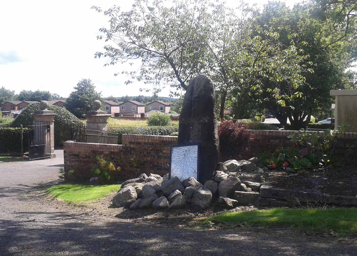
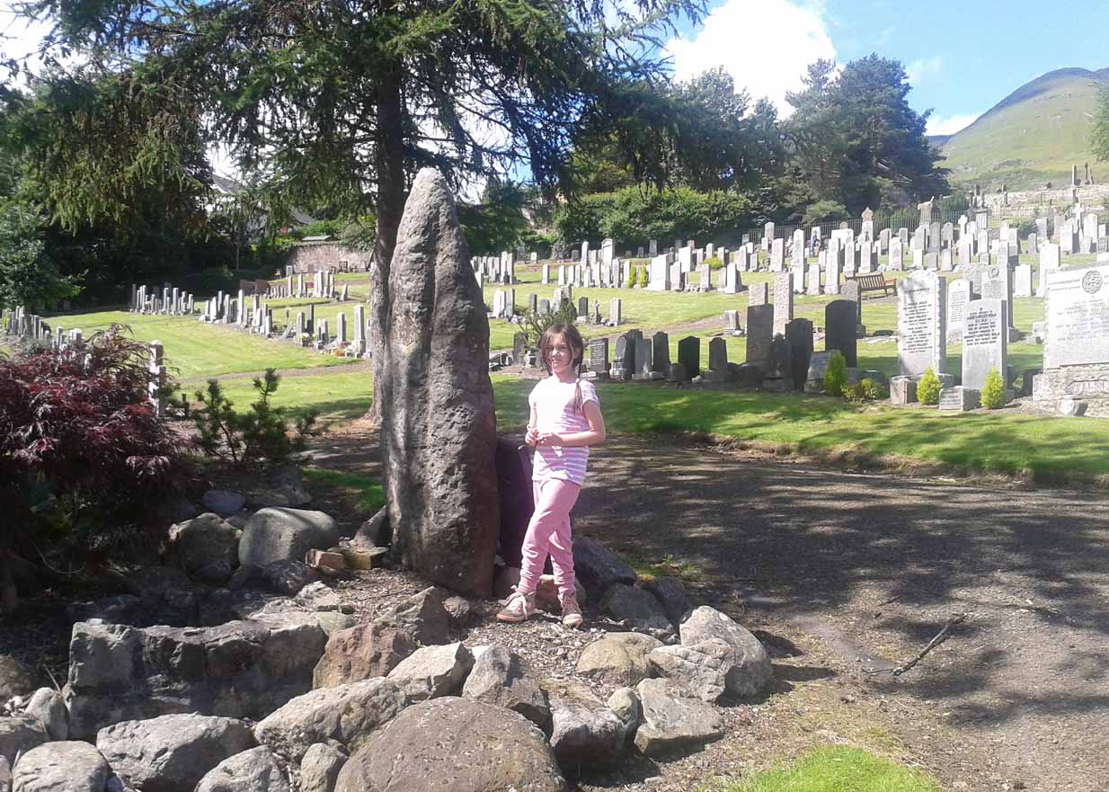
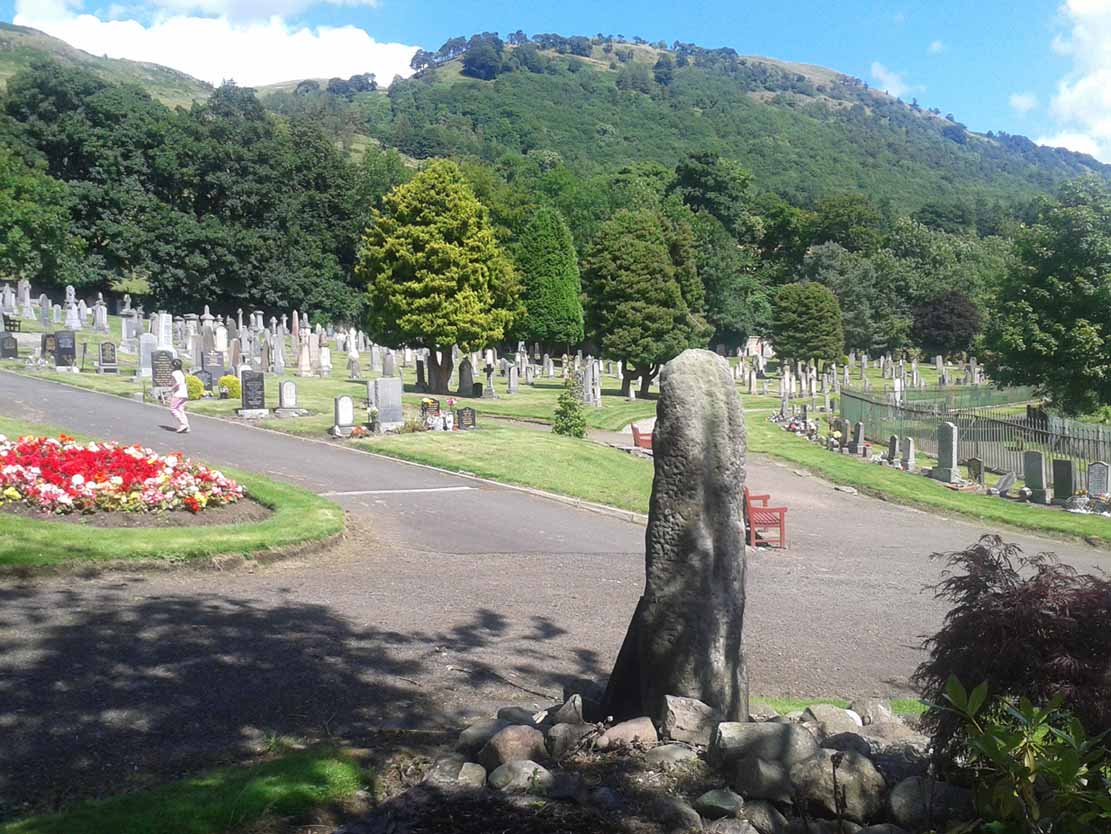
Go on the A91 through Alva, eastwards, and just before you go out of the town, note the small road on your left up to the graveyard. As you go into the graveyard, keep your eyes peeled on your left-hand side. You can’t really miss it!
Archaeology & History
Reported as “lost” or “destroyed” in many official reports, one of at least two standing stones that were reported in the Old Statistical Account of 1795 can still be found at the bottom of the graveyard, adjacent to the old holy well of St. Serf, at the edge of Alva town Very little has been written about it, and when it was mentioned in the OSA, the stones were only added in a foot note to the impressive stone cross on the outskirts of Alloa, saying:
“There are two stones resembling this one, in the neighbouring parish of Alva, at no great distance from the church, but not close to one another. They are both near the foot of the Ochils.”
A little person by its sideFrom the stone, looking NE
When some of the lads from the Scottish Royal Commission came here in July 1927, they could find no remains of any such standing stones and simply reported that they “no longer exist.” However, as visitors can plainly see, a tall upright standing stone still remains here, albeit repositioned by the good local people of Alva several decades ago. Standing more than seven-feet tall, the stone is very weather-worn on one side, with a plaque at the bottom.
References:
Royal Commission on the Ancient & Historical Monuments, Scotland, Inventory of Monuments and Constructions in the Counties of Fife, Kinross and Clackmannan, HMSO: Edinburgh 1933.
Follow the directions to reach the standing stone of Dunruchan D, and there on the moor immediately to your south, 100 yards or so away, it stands before you!
Archaeology & History
Dunruchan E stone, with Dunruchan D to rear
This is the southernmost of the impressive standing stones on the plain below Dunruchan Hill. Notably more ’rounded’ at the top than most of its associates—giving a more distinct ‘female’ nature to the stone than its companions—we find again, scattered around the base of this 7-foot tall monolith, a number of smaller rocks that gives the impression an old cairn was once here. Certainly there are a scatter of several other cairns nearby and we get the distinct impression with all of the Dunruchan stones, that a prehistoric cemetery was once in evidence here.
Ground-plan of stone & cairnCole’s drawing of Dunruchan E
Although this is the last of the known standing stones in this area, there is every probability of other prehistoric remains hidden amidst the heathlands—perhaps even more large standing stones that have fallen and are overgrown with vegetation. When Fred Cole came here one time with the great rock art writer, Sir James Simpson, one such fallen standing stone was reported a short distance tot he east, but it has yet to be recovered. There may be more.
In Fred Cole’s (1911) report of this particular “south stone”, or Dunruchan E, he wrote:
“This monolith, in respect of position, somewhat resembles the last, because it stands on the west arc of a rudely circular setting of small stones, which, however, are not placed on a mound (as in the case of Stone D), but merely lie on the flat of the moor. Five of these blocks are large enough to be noticeable, and they occupy the positions shown by the outlined stones in the ground-plan (fig. 21), the farthest to the east being 15 feet distant from the inner face of the standing monolith A. The dimensions of this Stone are: height 6 feet 9 inches, basal girth 16 feet 1 inch. In the illustration (fig. 22) I show this Stone with the other great one near set on its platform, and to the right two of the numerous small, low cairns which are scattered about this part of the moor. ”
Folklore
According to an account in the Ordnance Survey Name Book of 1860, “these stones are believed to mark the graves or commemorate the death of Roman soldiers who fell in a battle fought here between the Romans and the Caledonians.”
References:
Burl, Aubrey, From Carnac to Callanish, Yale University Press 1993.
Cole, Fred, “Report on Stone Circles in Perthshire, Principally Strathearn,” in Proceedings of the Society of Antiquaries, Scotland, volume 45, 1911.
Finlayson, Andrew, The Stones of Strathearn, One Tree Island: Comrie 2010.
Hunter, John, Chronicles of Strathearn, David Phillips: Crieff 1896.
Thom, A., Thom, A.S. & Burl, Aubrey, Stone Rows and Standing Stones – 2 volumes, BAR: Oxford 1990.
Dunruchan D Stone – with Dunruchan E in background
Follow the directions to reach the Craigneich standing stone, then across the road and uphill past the Dunruchan B standing stone, uphill further past the Dunruchan C standing stone and onto the moorland plain just behind it. You’ll see two large standing stones ahead of you on the moor to the south, a coupla hundred yards away. The nearest one is Dunruchan D.
Archaeology & History
Fred Coles’ 1911 drawing
Another fine large standing stone in this curious but excellent megalithic complex on the hills south of Comrie. This great monolith leans at a slight angle, and would be some 10 feet tall if the ages had kept it perpendicular. It’s truly impressive; and it emerges from the edge of a large raised cairn which almost surrounds it. The cairn is overgrown yet some 3-4 feet tall and made up of thousands of small stones. It’s the most notable of the cairns scattering the plains of Dunruchan, and gives the best impression of the standing stones here being memorials to some ancient chief, queen or shaman. As far as I know, this cairn has not been excavated, so we know not yet who or what lies beneath it.
Carved parallelogram design
A small section of the standing stone has some faded carving on its eastern side. These seem to be relatively recent, though a curious parallelogram design echoes the carving (albeit larger) on the Gleneagles B standing stone, 10 miles southeast, and which is thought to be Pictish. The carving here, however, doesn’t have that feel to it.
The stone and the cairn were noted in Fred Coles’ (1911) survey, in which he called this the “south-west stone” and wrote:
“New features are presented in combination with this Stone. In lieu of being set absolutely solitary on the heath, there are, extending for a considerable area almost around its base, many stones and boulders laid in the form of a flattish circular cairn or platform (see ground-plan). The monolith, which leans over towards the north, is set to the south of the crest of the cairn, and there is a considerable fall from the crest to the level of the moor around it, indicating that a very great quantity of small stones must have been employed in making the cairn. The interior, shown dotted on the plan, bears signs of having been partially excavated, probably the cause of the Stone being so much out of the vertical. The stony cairn or platform measures 15 feet in diameter, and consists of moderate sized stones. The base of the great Standing Stone is oblong, and measures in girth 14 feet 2 inches. Down the slope of its back the length is 10 feet, and its present vertical height 8 feet 6 inches. The longer axis is almost exactly due east and west. From this spot the next Stone in order can be easily seen…”
Coles’ groundplan of cairn & stone
Several other small cairns scatter this grassy and heathland plain, all of them overgrown and none of them excavated.
Dunruchan D, looking south
As with the other Dunruchan monoliths, this one has been included in the megalithic stone row surveys by both Alexander Thom (1990) and Aubrey Burl (1993), but the staggered alignment this has with the other standing stones is more likely fortuitous than deliberate. But this doesn’t detract from the magnitude of the megalithic cluster on this small section of moorland. A truly brilliant site!
Folklore
According to an account in the Ordnance Survey Name Book of 1860, “these stones are believed to mark the graves or commemorate the death of Roman soldiers who fell in a battle fought here between the Romans and the Caledonians.”
References:
Burl, Aubrey, From Carnac to Callanish, Yale University Press 1993.
Cole, Fred, “Report on Stone Circles in Perthshire, Principally Strathearn,” in Proceedings of the Society of Antiquaries, Scotland, volume 45, 1911.
Finlayson, Andrew, The Stones of Strathearn, One Tree Island: Comrie 2010.
Hunter, John, Chronicles of Strathearn, David Phillips: Crieff 1896.
Thom, A., Thom, A.S. & Burl, Aubrey, Stone Rows and Standing Stones – 2 volumes, BAR: Oxford 1990.
Follow the directions to get to the Dunruchan B standing stone, on the slopes south of Craigneich. Once there, on the hillside further above you, you’ll see a large upright stone on the moor about 300 yards to the south, standing just below the rise of a small hillock. That’s it!
Archaeology & History
Fred Coles’ 1911 drawing
The second biggest of the Dunruchan monoliths is what Fred Coles (1911) described as “the Middle Stone,” or Dunruchan C. Standing just below the rise of a large natural mound of earth, obstructing any immediate view of the western hills, it too has a long upright shape with a pointed end to the stone, leaning at a considerable angle. The massive stone of Dunruchan A is clearly visible on the grassy cairn-scattered plain 543 yards to the east and the smaller Dunruchan B to the north on the slopes below. Dunruchan C was deemed as one of the central stones in this unlikely megalithic stone row by both Aubrey Burl (1993) and Alexander Thom (1990). Mr Coles’ description of the site told:
“This huge block…rugged and irregular…makes, from the extraordinary angle at which it leans over southwards, a surprisingly picturesque object amid the heather and the various small boulders that lie scattered about in its vicinity. Of oblong basal section, the Stone tapers sharply up to a small narrow edge, which is at present 9 feet 4 inches in vertical height above the grassy ledge surrounding the base. In girth it measures over 17 feet, and the slope of its upper surface is over 12 feet in length. Intervening undulations in the moorland prevent one seeing the two Stones which stand farther down south-wards. The main axis of its base is N. 18° W. by S. 18° E. ”
Dunruchan C, looking eastThe leaning pillar of Dunruchan C
Once you walk onto the mound above this stone, the landscape opens up all round you. The southernmost monoliths of the Dunruchan complex awake to the south; what seems to have been another significant boulder sits low down a few hundred yards to the west; the faint outline of a large man-made enclosure of some sort is another 100 yards west of that; and the rocky mountains west and north of here captures you with a relaxing exultation, typical of the Scottish hills. This arena is an absolute must for all megalith fanatics!
Folklore
According to an account in the Ordnance Survey Name Book of 1860, “these stones are believed to mark the graves or commemorate the death of Roman soldiers who fell in a battle fought here between the Romans and the Caledonians.”
References:
Burl, Aubrey, From Carnac to Callanish, Yale University Press 1993.
Cole, Fred, “Report on Stone Circles in Perthshire, Principally Strathearn,” in Proceedings of the Society of Antiquaries, Scotland, volume 45, 1911.
Finlayson, Andrew, The Stones of Strathearn, One Tree Island: Comrie 2010.
Hunter, John, Chronicles of Strathearn, David Phillips: Crieff 1896.
Thom, A., Thom, A.S. & Burl, Aubrey, Stone Rows and Standing Stones – 2 volumes, BAR: Oxford 1990.


")
")

")

")


")

