Torrisholme Barrow, Morecambe, Lancashire

Tumulus:  OS Grid Reference – SD 4596 6425

Getting Here

Various ways up this old hill, visible from all angles it seems.  I came up via the housing estate near where us friend lives, near Bare Lane Station, through the houses and up the footpath.  But you can just as easy (if not easier) walk up from the country lane and fields beneath its eastern side.  Much nicer!

Archaeology & History

Torrisholme Barrow
Torrisholme Barrow

As many northerners will tell: gerrin information from the Lancashire archaeologists about prehistoric sites is troublesome (must be Southerners running the show!).  There’s tons of stuff in this good county, but archaeo-info is pretty poor on the ground.  This great old tomb for example, is designated as a “round barrow” on the Lancashire County Council monuments and records listing, but there’s no other info telling when it was dug, who by, the size of the tomb, what was found here, etc.  Pretty poor to be honest (c’mon chaps – get yer fingers out!).  The best info on-line comes from the more dedicated amateur enthusiasts.

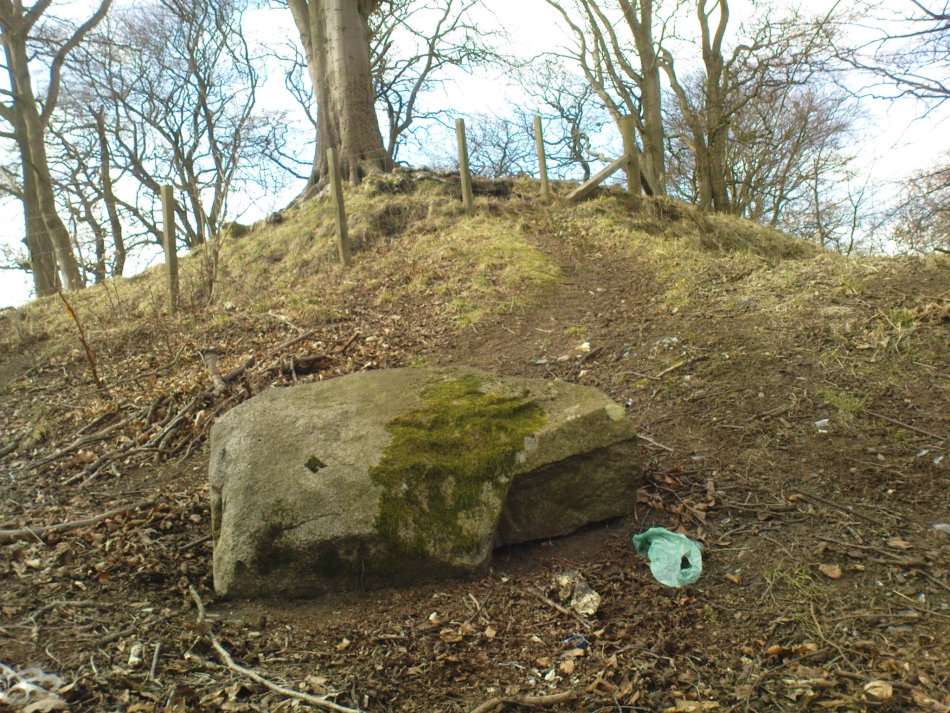
A local historian told us that there was nowt up here, but my nose told me otherwise — so up we tramped!  It was pretty obvious once we’d got to the top here, that some ancient mound had been built up.

“This has all the hallmarks of a tomb,” I said.

Torrisholme Barrow, looking SW

The spirit of the ancestor herein (whoever s/he was) had excellent views and flights to numerous important hills 360° all round here.  A perfect place for a tomb! And when we returned into the Darklands of our Yorkshire abodes, we found this notion to be true.  Marked on early OS-maps as a tumulus, next to the tell-tale giveaway route of Barrow Lane, there are passing mentions of it in a couple of old local history books I’ve come across, but I’ve yet to find much more about it.  It’s a fine mound and of decent size, well worth checking out if you’re in the area.  Once I get more details of the archaeological finds from here, I’ll add the data to TNA (but based on past performances and responses from Lancashire archaeo’s, I wouldn’t hold your breath…)

And for any Morecambe historians who might be able to find more: what — if anything — is known of the ‘Fartle Barrow’, now swallowed by the encroachment of the sea, just a few hundred yards west of here?

Early OS-map showing barrow

Folklore

In days of olde, this site was an old moot or meeting hill: one of the northern Law or council meeting hills.  Quite how far back this gathering tradition up here goes, aint known.  We do know however that there was a christian tradition enacted here, at Easter, of local church doods taking a cross up the top of the hill (does anyone know the story behind the old Cross Hill, half-a-mile south of here?).  There’s obviously quite a lot more pre-christian activities occurrent round here than has been previously thought.

© Paul Bennett, The Northern Antiquarian


Cunninghar, Tillicoultry, Clackmannanshire

Stone Circle (destroyed):  OS Grid Reference – NS 9256 9709

Also Known as:

  1. Druidical Temple

Archaeology & History

A stone circle was once to be found on the elevated piece of ground above the north-side of the main road between Tillicoultry and Dollar, but it was sadly destroyed sometime in the 19th century.  Listed in Aubrey Burl’s (2000) magnum opus, we have very little information about the place; though an account of the site was described in the Scottish Royal Commission report (1933) which told us that a —

“Stone circle, measuring about 60 feet in diameter, once stood here but was completely removed many years ago, when the stones, which are said to have been 5½ feet in average height, were taken to cover a built drain at Tillicoultry House”!

Site shown on 1866 OS-map
Stone at the destroyed site

Unbelievable!  Any decent local folk nearby wanna find out where this drain is, see if the stones are visible (though I doubt they are), so we can plan to uproot it and move the stones back somewhere nearby. There are a few decent spots on the slopes above where it would look good!

When visited by researchers in the 1890s, parts of an embankment which surrounded the destroyed circle were still visible.  Also, indicating there was some ritual funerary nature to the site, a local teacher called Mr Christie found the remains of an ornamented urn protruding through the ground next to where one of the monoliths had stood.  Unfortunately in his attempts to remove the urn, much of it crumbled away.

Further examinations thereafter found that a burial was (seemingly) beneath the centre of the circle; and excavations here found that a covering stone of the tomb was covered in intricate cup-and-ring designs (see the Tillicoultry House Carving for further details).  Other prehistoric remains were found a little further up the hill from here.

References:

  1. Burl, Aubrey, The Stone Circles of Britain, Ireland and Brittany, Yale University Press 2000.
  2. Morris, Ronald W.B., The Prehistoric Rock Art of Southern Scotland, BAR 86: Oxford 1981.
  3. Robertson, R., ‘Notice of the Discovery of a Stone Cist and Urns at the Cuninghar, Tillicoultry…’, in PSAS 29, 1895.
  4. Royal Commission on the Ancient & Historical Monuments of Scotland, Fife, Kinross and Clackmannan, HMSO: Edinburgh 1933.

© Paul BennettThe Northern Antiquarian


Robin Hood’s Stone, Riddlesden, West Yorkshire

Legendary Rock:  OS Grid Reference – SE 06228 44470

Getting Here

Marked on the 1853 OS-map

Dead easy!  If you come from Silsden, take the Holden Road up onto the moor edge, all the way up the wooded hill.  As you reach the top, keep your eyes peeled for the stone in the slope to your left.  Otherwise, coming from Riddlesden, take the moor road upwards (to Silsden Road) as if you’re gonna visit Peggy Mawson’s Well, the Baldwin Stone or some of the Rivock carvings.  Keep on the road to where you see the microwave tower on Pinfold Hill to your right.  It’s just below it!

Archaeology & History

Robin Hood’s Stone from above

Flints have been found on the slopes above here, but records of this stone only go back — as far as I’ve found — to 1850 (this seems to typify records around the Keighley district, which only seems to record anything post-1500 AD).  In mid-Victorian times, plans were afoot to use the rock for building material, but local people objected and so the stone kept its position overlooking the valley.  There are a number of very defined ‘cups’ on the sloping face of the stone, but several (though not all) of these have all the likeness of the holes dug into the rock by climbers — though why climbers would even think to cut foot-holes into this easy rock beggars belief!

Folklore

One of several sharp well-defined 'cups' on the rock
One of several sharp well-defined ‘cups’ on the rock

Not too surprisingly, folklore tells that this stone was one of the places where our old hero Robin Hood sheltered, when being chased by god-knows-who in one of his many exploits.  We’ve no way of proving this of course, but the sparse woodland remains above here also bear the hero’s name.  What seems to be a more modern piece of industrial folklore alleges that this stone was actually put here by workers in the Victorian times!  The boulder allegedly lived near Barden, Bolton Abbey, but was blocking construction work, so was uprooted and moved all the way to where it now sits!  In bygone times the rock was a local meeting place – perhaps around Beltane, in line with Robin Hood festivities.

References:

  1. Gray, Johnnie, Through Airedale from Goole to Malham, Elliot Stock: London 1891.

© Paul Bennett, The Northern Antiquarian


Peggy Well, Silsden, West Yorkshire

Healing Well:  OS Grid Reference – SE 0655 4413

Also Known as:

  1. Peggy Mawson’s Well
  2. Peggy’s Well

Getting Here

Peggy Mawson’s Well on 1853 map

From Riddlesden, take the road up to the moorland and Rivock Edge.  When you reach the top (Silsden Road), turn left.  Go on for about 600 yards till you reach the lovely tree-hidden old cottages of Holden Gate, on your right.  Stop — and walk down the footpath opposite from here.  As the wall goes down, you’ll notice a stream in the next field to your left, emerging from a clump of large rocks.  That’s it! (there’s a footpath in the next field from the roadside)

Archaeology & History

Shown on the first OS-map as ‘Peggy Mawson’s Well,’ little else seems to known of this place; though it obviously got its name after the local lady, Peggy Mawson.  I can find no further information about this lady, nor why the site was named after her.  Any help here would be hugely appreciated!

Peggy Mawson’s Well – now drained-off through pipes

Sadly the waters from beneath the rocks have been channeled into a couple of pipes and the well no longer runs.  All that’s left is a small boggy region just in front of the boulders.  You have to walk about 100 yards further down the field where the water emerges from a modern pipe.  It doesn’t taste as nice as it originally did when coming straight from the ground, but it’s still quite drinkable (certainly beats any of the chlorinated stuff* that customers are forced to pay for, whether we want it or not – and most people don’t want it).

Folklore

This site has acquired modern folklore, but sadly no early traditions have been found.  Whelan & Taylor (1989) thought that Peggy Well’s “dedication suggests a connection with St. Margaret,” which unfortunately isn’t the case.  Several years later another writer, Val Shepherd (1994), spun the speculation even further, not checking the historical background to the site, and thought that “the well’s name may be derived from the water spirit, ‘Peg,’ who gave her name to other wells.”  Sadly neither idea holds any sway.

References:

  1. Shepherd, Val, Historic Wells in and Around Bradford, HOAP: Loughborough 1994.
  2. Whelan, Edna & Taylor, Ian, Yorkshire Holy Wells and Sacred Springs, Northern Lights: Pocklington 1989.

* Anyone know about this: surely because the water companies chlorinate and add other undesirable toxins into our tap water, what we’re actually drinking is a very weak solution and not actually water.  Isn’t that a trading standards violation?

© Paul Bennett, The Northern Antiquarian


Robin Hood’s Wood (3), Silsden, West Yorkshire

Cup-Marked Stone:  OS Grid Reference – SE 06530 44898

Also Known as:

  1. Holden CR1

Getting Here

Follow the same directions to reach the Robin Hood’s Wood Stone, but head from there to the dirt-track about 30 yards away.  This stone is just 10-15 yards on the south-side near the bend in the track.  Look around!

Archaeology & History

Holden Cup-Marked Rock

If you can find this stone, the 2-cupped Robin Hood’s Wood Stone carving is only about 15 yards SW.  But this poor example is a mere single cup-mark sitting near the centre of a large flat rock, half-covered in vegetation like its nearby compatriot.  There’s a faint possibility of a second cup-mark on the rock, but it’s pushing it a bit!  Thanks to the vegetation cover on the majority of the rock, the cup’s in a good state of preservation.  Nowt much to shout about unless you’re a real cup-and-ring nut!

© Paul Bennett, The Northern Antiquarian


Robin Hood’s Wood CR-2, Silsden, West Yorkshire

Cup-Marked Stone:  OS Grid Reference – SE 06521 44887

Getting Here

Follow the same directions for reaching the Baldwin Stone.  From here, with your back to the wall, face the small remnants of Robin Hood’s Wood and walk straight to where the game-keeper’s stuff is in the trees 150 yards straight in front.  Go through the small copse and out the other side, in a straight line for another 70 yards.  This stone’s mainly covered over with vegetation (and we covered most of it back over again) so you might have trouble finding it.  But with patience and a good nose, you’ll find it hereabouts!

Archaeology & History

Robin Hood's Wood Cup-Marks
Robin Hood’s Wood Cup-Marks

Another previously undiscovered carving, found yesterday (12.6.09) by Michala Potts after rummaging for sometime amidst the mass of Juncus grasses which cover the plain immediately north of Robin Hood’s Wood.  Not much to see unless you’re a real rock-art freak, as we only have two definite cup-markings on the stone.  A possible third cup can be seen closer to the NW edge, where the rock becomes more crystalline.

I was rather intrigued by Mikki’s find, as when she shouted me over, found that she’d rolled much of the vegetation back that had been covering the stone.  Without rolling the grasses back from the surface, she wouldn’t have found the cup-marks; and considering the number of stones that scatter this plain, I asked why she’d chosen to uncover this one and not the others.

“It told me to!” she said in that blunt Yorkshire way.

“Aaahhh,” I thought…

© Paul Bennett, The Northern Antiquarian


Rough Holden CR-7, Silsden, West Yorkshire

Cup-and-Ring Stone:  OS Grid Reference – SE 06918 45020

Getting Here

Rough Holden Cup-and-Ring Stone

Another carving that might take a bitta finding.  Follow the same directions for reaching the Holden Buttock Stone, going past it towards the fence 100 yards away.  Go through the gate and walk along the path for a couple of hundred yards.  As you walk down, you’ll eventually see the cluster of rocks amidst which lives the Dump Stone carving.  This, the Rough Holden cup-and-ring, is off the path (right) before you get to them in the grasses.  Look around.

Archaeology & History

Rediscovered in June 2009 by Michala Potts and I, this little stone at first only appeared to possess a few cup-markings, but the more we looked at it, the more obvious it became that one of the cups had a nice ring surrounding it.  Unfortunately this didn’t come out at all well in any of the photos we took, so we need to another visit here whe the sunlight’s right to get a decent image.  Aswell as that, the drawing we did of the basic design appears to be missing what looks another blatant cup-marking near the centre of the rock, which did not seem at all obvious to the naked eye when we found it. (such are the delights of assessing cup&rings!)

Rough Holden cup-marks
First sketch of the stone
Basic sketch of the stone

The main cluster of cups occurs on the northern-edge of the stone, where a couple of them seem linked by linear features.  There are also what may be a cup or three on the vertical edge of the rock, below these cups – but this needs looking at again the better lighting.   The cup-and-ring is very faint, but once noticed it become increasingly obvious that it’s there, and most of the ring can be traced with ease by running one’s finger along the groove.  Mikki reckons the ring runs all the way round the cup (she’s probably right), where as I could only work it out running 75% of the way round.  The line which runs off above the ring seems to link up with what looks like another obvious cup-marking on the photo.  We’ll have to check it out properly next time we’re up there!

© Paul Bennett, The Northern Antiquarian


Holden Buttock Stone, Silsden, West Yorkshire

Cup-Marked Stone:  OS Grid Reference – SE 06886 44723

Also Known as:

  1. Rough Holden CR-5

Getting Here

Holden Buttock Stone and its faint cups

A bit troublesome this one – and the 8-figure grid-ref might be slightly astray (though only by a little).  Get to the TV-mast below Rivock Edge and notice the small path going along the top of the adjacent field, over the fence, heading north-ish into the meadows — not the path into the forest.  Walk on the meadow path, over the wall and notice a rise in the ground ahead of you.  Go past this mound for about 75 yards and keep your eyes peeled!

Archaeology & History

Close-up of cup-markings

Named by virtue of the shape of the stone, the Keighley volunteer Michala Potts of Bracken Bank found this carving on an exploratory amble yesterday (Friday, June 12, 2009).  Previously unrecorded, this carving consists merely of cup-markings — four distinct ones on the northeasterly edge of the rock, with two other ‘possibles’ thereon.  The cups have been pretty well-eroded by the elements and there are few distinguishing features which will make this of any real interest, unless you’re a real rock-art freak!

© Paul Bennett, The Northern Antiquarian


Rivock Nose (2), Keighley, West Yorkshire

Cup-Marked Stone:  OS Grid Reference – SE 07360 44629

Also Known as:

  1. Carving no.11 (Hedges)
  2. Carving no.46 (Boughey & Vickerman)

Getting Here

Follow the same directions for reaching the Wondjina Stone.  Once here, walk to the edge of the cliffs less than 10 yards away and the second largest of the rocks is the one you’re after. (the Rivock Nose [1] and [3] carvings are the rocks either side of this one)

Archaeology & History

Possible cup-markings at Rivock Edge

I’ve gotta admit, I was slightly surprised to find this carving logged in both Hedges (1986) and Boughey & Vickerman’s (2003) surveys.  Although we find the distinct appearence of cup-markings near the edge of the cliff at the northwestern end of Rivock Edge, these seem a little too close to being natural to be comfortably acknowledged in archaeo-texts without notes the contrary.  I took a photo of them when we were up visiting the other day, but didn’t expect them to be in the books.  Not only do they include this probably natural example, they also add another two rocks found along the cliff edges (Hedges 12 & 13; B&V 45 & 47).  In the event that these carvings are deemed authentic, then those along the edge of the great Kirk cliffs above Steeton must also be added to the same pot.

In the photo here you can work out perhaps nine cup-marks near the edge of the cliff, which is what the textbooks say.  Make your own mind up when your next looking at the Wondjina Stone and others nearby.

References:

  1. Boughey, Keith & Vickerman, E.A., Prehistoric Rock Art of the West Riding, WYAS 2003.
  2. Feather, Stuart, ‘Mid-Wharfedale Cup-and-Ring Markings: Nos. 7 & 8, Rivock Edge,’ in Cartwright Hall Archaeology Group Bulletin, 6:8, 1961.
  3. Hedges, John (ed.), The Carved Rocks on Rombald’s Moor, WYMCC: Wakefield 1986.

© Paul Bennett, The Northern Antiquarian 


Niplet Stone, Rivock, Keighley, West Yorkshire

Cup-Marked Stone:  OS Grid Reference – SE 07481 44452

Also Known as:

  1. Carving no.23 (Hedges)
  2. Carving no.59 (Boughey & Vickerman)

Getting Here

Niplet Stone (after Hedges)

Follow the same directions to reach the nearby Wondjina Stone, but as you reach the trig-point at the top of Rivock Edge, note the smooth rounded boulder 50 yards ESE.  That’s it!

Archaeology & History

Named after the sea of cotton grasses, or niplets (Eriophorum angustifolium), amidst which it lives for several weeks of the year, the cups-marks that make up this design can be terribly difficult to work out even in the best of lighting.  We have here a lichen-encrusted stone with perhaps as many as 25 cup-marks scattering, mainly, the top and westerly sloping face.  Although some of the cups are quite noticeable, the vegetative growth and simple erosion has made an accurate visual impression of the original carving very difficult — as the images plainly tell!  If I ever manage to capture the stone resting in a good mood, I’ll replace the photos I’ve got here!

Niplet Stone, looking SE
Beautiful fusion of faded cups, lichen & great age...
Beautiful fusion of faded cups, lichen & great age…

Although I remember coming here and seeing this and the nearby carvings when I was a teenager, then a few years later on with Edna Whelan and Graeme Chappell, it seems that the first literary note of this carving after my own initial exploration was in the Ilkley Archaeology Group’s survey (Hedges 1986), where they make note of a flint that was found beside the stone.  Boughey and Vickerman (2003) later include the same stone in their work, but with no additional information.

References:

  1. Bennett, Paul, “The Prehistoric Rock Art and Megalithic Remains of Rivock & District (parts 1 & 2),” in Earth, 3-4, 1986.
  2. Boughey, Keith & Vickerman, E.A., Prehistoric Rock Art of the West Riding, WYAS 2003.
  3. Hedges, John (ed.), The Carved Rocks on Rombald’s Moor, WYMCC: Wakefield 1986.

© Paul Bennett, The Northern Antiquarian