Nettlehole Ridge, Skipton, North Yorkshire

Stone Circle:  OS Grid Reference – SD 9794 5634

Also Known as:

  1. Crookrise Woods

Getting Here

Nettlehole Ridge 'circle'
Nettlehole Ridge ‘circle’

There are several ways to get here, but I took the one from the road (B6265) walking up the track into Crookrise Woods. Unless you’ve got a decent OS-map with it marked on, this might take some finding to some folk as it’s tucked away on the northern edge of Crookrise Woods (which one Southerner bloke told us was private – though he was ‘allowed’ there!). It’s right on the rounded knoll at the top of the woods, beneath the prominent slopes which lead to the moor.

Archaeology & History

Our old mate and Yorkshire historian Arthur Raistrick seems to have been the first to describe this place in the Yorkshire Archaeological Register of 1964 – though the holy wells writer Edna Whelan told me she knew about the place many years back. Today hidden in woodland and mostly overgrown, Raistrick’s brief description of the place said:

“A small stone circle of six stones set symmetrically within a diameter of 26 feet. The stones vary in size from 21 to 58 inches. Surveyed 1963.”

The site has been badly affected by the erosion of time, forestry and god-knows what else.  Scattered around are numerous small stones giving the impression that it may once have been a cairn-circle, more than a stone circle.  Four of the six stones mentioned by Raistrick (1965) are visible, but none are impressive – and unless you’d read about the place first or found it in Mr Burl’s Stones Circles of Britain… (2000), you  wouldn’t really give it the time of day.

Although sadly disappointing in its present status – completely surrounded by trees, with no view at all – it seems probable that it would have had some geomantic relationship with the hillfort-looking site of Rough Haw immediately west, and very probably the adjacent ritual site of Sharp Haw.  It seems that the equinox sun would set between Rough Haw and the other small rounded hill above.

References:

  1. Burl, Aubrey, The Stone Circles of Britain, Ireland and Brittany, Yale University Press 2000.
  2. Raistrick, Arthur, ‘Yorkshire Archaeological Register: Embsay,’ in Yorkshire Archaeological Journal, 1964.

© Paul Bennett, The Northern Antiquarian


Weecher Stone Circle, Faweather, Baildon, West Yorkshire

Stone Circle (destroyed):  OS Grid Reference – SE 1372 4196

Getting Here

Although destroyed, to those who wanna check the locale, from Bingley take the Eldwick road and keep going all the way up to Dick Hudson’s public house, right on the edge of the moor.  From here, go left (east) on the road for less than a mile until you reach the reservoir/lake on your right.  Take the dirt-track down here for 100 yards and stop!  It was somewhere here!

Archaeology & History

I first went looking for this site when I was a kid (about 13 years old), but soon discovered that it had been destroyed.  The first person to write about it was lucky enough to see it when it was still there.  Harry Speight came here around 1890 and described,

“descending (from Pennythorn Hill) towards Faweather we enter (by permission) a field at Birch Close Farm, and here we find evidence of an extensive stone circle, some of the large unhewn stones having been built into an adjoining wall. In the next field is a rock sculpture with…cup and ring marks.”

This cup-marked stone still exists at Faweather, though has now been enclosed by a garden. The occupiers are quite friendly and are willing to let you look at the stone if you ask kindly.  Anyway…..by the time Butler Wood wrote about the place in 1905, he was telling that “the finest stone circle in the Rombald’s Moor area was demolished some years ago.”

The local historian W.E. Preston, marking an old map of the region with an “X,” wrote:

“NOTE! The circle was destroyed here during construction of the Baildon Waterworks, 1892. Diameter 25 yards. It consisted of a wall of rubble with upright stones at frequent intervals.”

Subsequent descriptions of the site in 1905, 1929 and 1946, cited Weecher to be 27 yards across.  My last search for any remains of this circle was in 1990 when I explored every wall in the region, hoping to find one or two of the old uprights, but they had all gone. Sadly, there appear to be no drawings or illustrations of the site either…

Folklore

This stone circle was one of at least four circles that played a part in one of the most impressive leys I have seen! Starting at the circle in Hirst Woods, Saltaire, the alignment goes north, crossing the Brackenhall circle, a few other Bronze Age sites, across the site of Weecher, and finally terminates at the Great Skirtful giant tomb a short distance north of here.

References:

  1. Bennett, Paul, The Old Stones of Elmet, Capall Bann: Milverton 2001.
  2. Cowling, E.T., Rombald’s Way, William Walker: Otley 1946.
  3. Gray, Johnnie, Through Airedale from Goole to Malham, Walker & Laycock: Leeds 1891.
  4. Raistrick, Arthur, ‘The Bronze Age in West Yorkshire,’ in YAJ 1929.
  5. Wood, Butler, ‘Prehistoric Antiquities of the Bradford District,’ in Bradford Antiquary, 2, 1905.

© Paul Bennett, The Northern Antiquarian


Harden Moor Circle, Bingley, West Yorkshire

Ring Cairn:  OS Grid Reference – SE 07496 38675

Getting Here

Harden Moor circle01
Harden Moor Circle, looking SE

From Harden, go up Moor Edge High Side (terraced row) till you reach the top. Follow the path thru’ the woods on the left side of the stream till you bend back on yourself and go uphill till you reach the moor edge. Keep walking for about 500 yards and keep an eye out to your immediate left.  The other route is from the Guide Inn pub: cross the road and go up the dirt-track on the moor-edge till you reach a crossing of the tracks where a footpath takes you straight onto the moor (south). Walk on here, heading to the highest point where the path eventually drops down the slope, SE. As you drop down, watch out for the birch tree, cos the circle’s to be found shortly after that, on your right, hidden in the heather!

Archaeology & History

This aint a bad little site hidden away on the small remains of Harden Moor, but is more of a ‘ring cairn’ than an authentic stone circle (a designation given it by previous archaeologists).  An early description of it was by Bradford historian Butler Wood (1905), who also mentioned there being the remains of around 20 small burials nearby.  When the great Sidney Jackson (1956; 1959) and his team of devoted Bradford amateurs got round to excavating here, he found “four or five Bronze Age urns” associated with the circle.  His measurements of the site found it to be 24 feet across, and although the stones are buried into the peat with none of them reaching higher than 3 feet tall, it’s a quietly impressive little monument this one.  About 20 upright stones make up the main part of the ring.

I’ve visited the place often over the last year or so since a section of the heather has been burnt away on the southern edges of the circle.  This has made visible a very distinct surrounding raised embankment of packing stones about a yard wide and nearly two-feet high, particularly on the southern and eastern sides of the circle, giving the site a notable similarity in appearance and structure to the Roms Law circle (or Grubstones Ring) on Ilkley Moor a few miles to the north.

There is also the possibility that this ring of stones was the site described by local historian William Keighley (1858) in his brief outline of the antiquities of the region, where he wrote:

“On Harden Moor, about two miles south of Keighley, we meet with an interesting plot of ground where was to be seen in the early days of many aged persons yet living, a cairn or ‘skirt of stones,’* which appears to have given name to the place, now designated Cat or Scat-stones. This was no doubt the grave of some noted but long-forgotten warrior.

* The Cairn was called Skirtstones by the country people in allusion to the custom of carrying a stone in the skirt to add to the Cairn.”

However, a site called the ‘Cat stones’ is to be found on the nearby hill about 500 yards southeast – and this mention of a cairn could be the same one which a Mr Peter Craik (1907) of Keighley mentioned in his brief survey of the said Catstones Ring at the turn of the 20th century.  We just can’t be sure at the moment.  There are still a number of lost sites, inaccuracies and questions relating to the prehistoric archaeology of Harden Moor (as the case of the megalithic Harden Moor Stone Row illustrates).

Section of the inner ring

The general lack of an accurate archaeological survey of this region is best exemplified by the archaeologist J.J. Keighley’s (1981) remark relating specifically to the Harden Moor Circle, when he erroneously told that, “there are now no remains of the stone circle on this site” — oh wot an indicator that he spent too much time with paperwork!  For, as we can see, albeit hidden somewhat by an excessive growth of heather, the ring is in quite good condition.

It would be good to have a more up-to-date set of excavations and investigations here.  In the event that much of the heather covering this small moorland is burnt back, more accurate evaluations could be forthcoming. But until then…..

References:

  1. Bennett, Paul, The Old Stones of Elmet, Capall Bann: Milverton 2001.
  2. Craik, Peter, “Catstones Ring,” in C.F. Forshaw’s Yorkshire Notes & Queries, volume 3 (H.C. Derwent: Bradford 1907).
  3. Faull, M.L & Moorhouse, S.A. (eds.), West Yorkshire: An Archaeological Survey to AD 1500 – volume 1, WYMCC: Wakefield 1981.
  4. Jackson, Sidney, “Harden Moor Circle,” in Cartwright Hall Archaeology Group Bulletin, 1:18, June 1956.
  5. Jackson, Sidney, “Harden Circle Found,” in Cartwright Hall Archaeology Group Bulletin, 2:1, July 1956.
  6. Jackson, Sidney, “Bronze Age Urn found on Harden Moor,” in Cartwright Hall Archaeology Group Bulletin, no.7, 1959.
  7. Keighley, J.J., “The Prehistoric Period,” in Faull & Moorhouse, WYMCC: Wakefield 1981.
  8. Keighley, William, Keighley Past and Present, Arthur Hall: London 1858.
  9. Wood, Butler, ‘Prehistoric Antiquities of the Bradford District,’ in Bradford Antiquary, volume 2, 1905.

© Paul Bennett, The Northern Antiquarian


Haer Stanes, Llanbryde, Banffshire

Stone Circle (destroyed):  OS Grid Reference – NJ 2691 5985

Also Known as:

  1. Haerstanes
  2. Harestones

Archaeology & History

Haer Stanes on the 1871 map

This site had already passed into memory when the Ordnance Survey lads visited the area in 1870, but at least they included it on their early survey.  Fred Coles (1906) described this site in his essay on the megaliths of Banffshire, where once could be found perhaps five stone circles close to each other – but all are now gone!  Bloody disgraceful really.  When Coles explored here, although the site was still shown on maps, little could be seen of the place.

“On the farm,” he wrote, “we heard long-handed-down tradition of the Circle, and the site was, rather vaguely, pointed out.” But there was nothing there. He described one reference to the place written by a Mr James Morrison, who said, “We have remains of two so-called Druid Circles, and during the last half-century three others have been swept away. One of these was in horse-shoe form and was called the Haer Stanes.” The same writer later says, “These stones were unfortunately found to lie in the line of a road then formed (1830) and were ignominiously tumbled down the slope on which for ages they had rested, and buried in a gravel pit by the side of the road.”

References:

  1. Cole, Fred, ‘Report on Stone Circles Surveyed in the North-East of Scotland…’, in Proceedings of the Society of Antiquaries, Scotland, volume 40, Edinburgh 1906.

© Paul Bennett, The Northern Antiquarian


Gull Stones, Great Yarmouth, Norfolk

Stone Circle (destroyed):  OS Grid Reference – TG 524 035

Archaeology & History

Several local history records describe there being a circle of ten standing stones in a field called ‘Stone-field’ or ‘Stone-piece’ – now covered by a housing estate at Gorleston-on-Sea, south of Yarmouth.  In 1875, C. J. Palmer said that,

“there is a tradition that the Druids had a temple at Gorleston, some remains of which existed down to a comparatively recent period. It is supposed to have stood on a field next to the road to Lowestoft, upon what is called Great Stone Close; and it has been asserted that some huge stones remained standing until 1768, when they were destroyed by digging round their base and dragging them down by ropes. There are also two fields called Further Stone Close and Middle Stone Close, so that it is possible the Druidical circle, if it ever existed, may have had a wide extent”.

A painting of the site was reported to have been viewed by members of the Norfolk & Norwich Archaeological Society in 1888, but I’ve been unable to find out where this has gone.  Anyone out there got a copy?  Or know where it hangs?  An image of this lost stone circle would be hugely welcome!

References:

  1. Burgess, Michael W., The Standing Stones of Norfolk and Suffolk, ESNA 1: Lowestoft 1978.
  2. Palmer, C.J., The Perlustration of Great Yarmouth – volume 3, George Nall: Gt Yarmouth 1875.

Links:

  1. Hidden East Anglia: Ancient Sites & Legends

© Paul Bennett, The Northern Antiquarian


Frogden Circle, Linton, Roxburghshire

Stone Circle (destroyed):  OS Grid Reference – NT 774 292

Also known as:

  1. Five Stones
  2. The Tryst

Archaeology & History

Less than a mile northwest of the hillfort on Linton Hill, modern OS-maps show the field-name of ‘Five Stone Field’ which is where, in bygone years, another important stone circle once stood.  Today unfortunately, not a single stone remains.  As the Scottish Royal Commission (1956) lads told:

“About a mile NE of Frogden, on the N side of the road between Frogden and Greenlees, there were formerly five or six upright stones forming a circle, ‘about the size of a cock-pit’ (1792 Statistical Account). This circle, which was adopted as a rendezvous by Border raiders in the Middle Ages and became known as The Tryst, has long since disappeared, but its approximate site is indicated on the OS map by the name Five…Stone Field.”

Folklore

One of many stone circles used as an old moot, or gathering spot.  This was described in one of the many footnotes to Sir Walter Scott’s (1802) Minstrelsy of the Scottish Border, in which he told:

“At Linton, in Roxburghshire, there is a circle of stones surrounding a smooth plot of turf, called the Tryst, or place of appointment, which tradition avers to have been the rendezvous of the neighbouring warriors. The name of the leader was cut in the turf, and the arrangement of the letters announced to his followers the course which he had taken.”

This tradition was echoed around the same period in Robert Forsyth’s (1805) massive work on the history of Scottish life and landscape, saying:

“In different parishes, such as Moorbattle, Linton, and others, are to be found what are called tryst stanes. These are great stones commonly situated on high grounds. They are placed perpendicularly in rows, not unfrequently in a circular direction. It is said, as also the name imports, that in times of hostility they marked the places of resort for the borderers when they were assembling for any expedition of importance.”

References:

  1. Burl, Aubrey, The Stone Circles of Britain, Ireland and Brittany, Yale University Press 2000.
  2. Forsyth, Robert, The Beauties of Scotland – volume 2, Thomas Bonar: Edinburgh 1805.
    Royal Commission on the Ancient & Historical Monuments of Scotland, Roxburghshire – volume 1, HMSO: Edinburgh 1956.
  3. Scott, Walter, Minstrelsy of the Scottish Border, James Ballantyne: Kelso 1802.

© Paul Bennett, The Northern Antiquarian


Machuim, Lawers, Loch Tay, Perthshire

Stone Circle:  OS Grid Reference – NN 68201 40156

Also Known as:

  • Lawer’s Mill

Getting Here

From the north-end of Loch Tay at Kenmore, follow the road (A827) round down the lochside, through the village of Fearnan and then another 4 miles down.  If you park up at the pub at Lawers, walk back up the road for ½-mile, keeping your eyes peeled up the slope on the left where you’ll see the circle visible from the road.

Archaeology & History

Much has been said of this fine old place – also known as Lawer’s Mill – which seems to have been first described by Thomas Pennant in his rambling Tour in Scotland (1772).  The local writer William A. Gillies (1938) told that after

“a recent examination of the ground around the circle…suggests that at one time there was an outer circle of stones concentric with the existing one. Most of the stones were removed in order to make more of the field available for cultivation, but there are still large stones buried within a few inches of the surface.”

Folklore

In J. McDiarmid’s Folklore of Breadalbane (1910) he tells of a man from Killin who, on passing by this old circle, heard haunting fairy music.  Being inquisitive, he walked up to see what was going on and walked into the circle where the little people were playing.  He was obviously lucky and the faerie-folk enjoyed his company, for when he left he was given the gift of a strong, fast, white steed.

Solar folklore may be…?

References:

  1. Gillies, William A., In Famed Breadalbane, Munro Press: Perth 1938.

© Paul Bennett, The Northern Antiquarian


Crow Hill Circle, Midgley Moor, West Yorkshire

Ring Cairn: OS grid reference – SE 026 271

Getting There

Best approached by taking the same direction to the unexcavated Foster Clough ‘enclosure.’ From here, walk towards the walling about 100 yards to your east. Follow it along on the moorside for another 100 yards then follow the small sheep-path up the angle of the slope onto the moor itself. Once you’re at the top and on the level, it’s right ahead of you! If the heather’s deep though, you might as well give up before y’ start! (honest – I went there a while back for a night’s sleep & couldn’t find the damn thing!) But if you’ve made the effort getting here, wander 200 yards towards Crow Hill and keep yer eye out for the large heather-clad tumulus.

Archaeology & History

This site was rediscovered in October 1995, when I was bimbling about on the southern side of Crow Hill. It was one of those good periods, when the heather had been extensively burnt back, so enabling a better examination of the moors for any potential prehistoric remains. I unknowingly walked right into the middle of this small ring of stones with a fella called John Billingsley, who seemed quite unaware of what I was getting excited about until I pointed out to him exactly what we were standing in the middle of! (he couldn’t see what was under his nose, which was a bit weird considering he edits an earth-mystery mag) But I wouldn’t have even been looking for this site, were it not for what happened just a few days earlier…

I was on one of my many ambles across the moortops, which to many people watching would seem like some seemingly aimless, lost soul – an apt description at times! – wandering across the hills (those who know me well, have long called such seemingly aimless treks, Barmy Bennett Expeditions!). It was a lovely day: a shallow snow-cover lay across the moors and as the wind brushed across the earth and up, Her wisps of breath were freezing. But I was well-wrapped and sat, upon occasion, behind the small rock outcrops I was checking for cup-and-rings for shelter when needed. But as the day fell on and the sun touched the western hills, I had to turn for home as the cold was strengthening. Being on the moors at night, in this sort of weather, is never a good idea unless you’ve got your gear with you — and this day I hadn’t. So I set off back for home in Hebden Bridge, in that dreamy sort of state which the hills elicit after a day’s ambling. The colours of Earth and Sky were crisp in the bracing air and as I headed for the footpath towards the old stone known as Churn Milk Joan, I gazed at Crow Hill a half-mile or so away…

Without warning, it came like a thunderbolt up through my dreaming mind: ‘There’s a stone circle over there!‘ came the words. And though the words were quiet and simple, their effect was anything but! I focused quickly – very quickly! My mind staggered out of the dreaming and into the ego state, trying quick to rationalise what had just emerged from my unconscious. An adrenalin rush hit me and amidst the snow-filled hills I started to bound, gazelle-like, across the wibbling moors, straight towards Crow Hill. But then I stopped!

“Wait… She’s nearly dark,” I said to myself. “You’ve no food and there’s gonna be no no light. Come back in a day or two and you’ll have all the time you need to explore.”

And so I wandered back in the dark to the warmth of fire and home and waited a few days, for the Earth to drink Her snow, and hope that the curious intuition — as it had been on numerous other occasions — proved fruitful. And so it did…

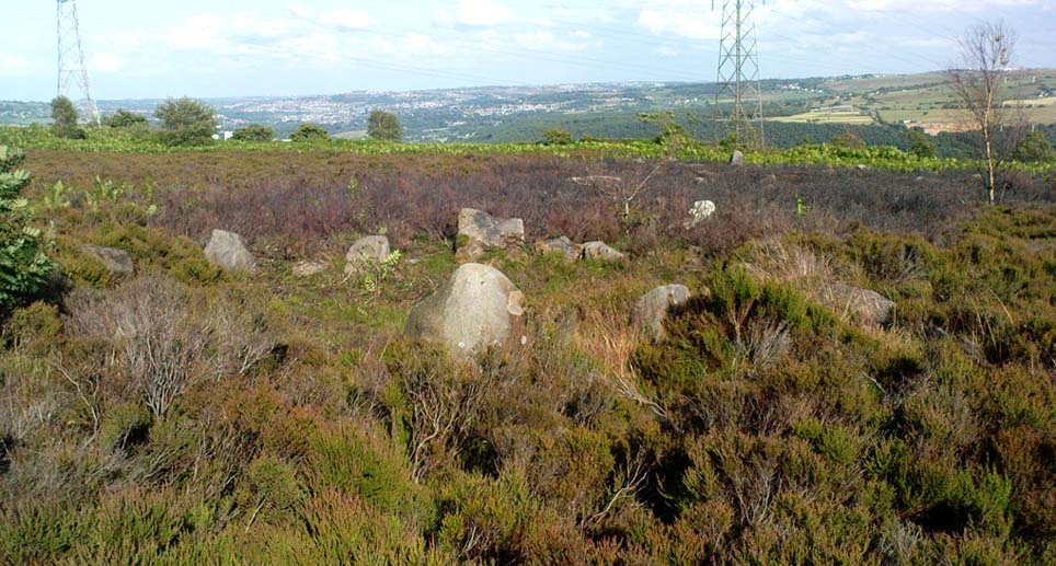
If you can find the place (almost impossible when the heather’s in full growth), you’ll see that this ‘cairn circle’ is little more than 32 feet across, with the tallest stone in the ring little more than 2 feet tall. A curious small squared circle of loose stones exists in the south side of the ring and a raised embankment surrounds the site. Scatterings of small, football-sized stones are found both in, out and at the edge of the circle. (Please note – to those of you who wanna cross-reference – that the photos alleging to show this site on The Megalithic Portal are not of the right place.)

Close by are other neolithic remains, including extensive walling, 2 or 3 other small standing stones and a large tumulus which one rather myopic hobbyist (Mike Haigh) reckoned – in a poor attempt at sarcasm – might be the burial tomb of a successful local farmer.  Hmmmm…..

The site was later described in an article by the same Mike Haigh (in Billingsley’s Aspects of Calderdale) as being discovered by John Billingsley himself, which wasn’t just a mistake but a rather huge lie.  John was there with me when I found it, as he knows full well.  But it seems here we have an example of people who like to try give themselves credit for discovering things that they did not do.*  Even sillier, Mr Billingsley then moaned when I described the site (in my Old Stones of Elmet) without mentioning his name! But in all honesty, if that’s the disreputable way in which they go about their business, what do they expect in return!? (What’s worse is that the site was first described in an article in his own Northern Earth Mysteries mag in 1995, which I co-authored, and then when I asked if he could point out the error and correct it, he ignored the request in just the same way politicians do.  Pure bloody ignorance no less.  But then, he is one of those incoming Southern-types – y’ know the sort…)

This aside: the entire region hereabouts requires considerable archaeological attention as we have here the remains of either a neolithic settlement, or graveyard, or both!

* see the note at the bottom of the ‘About TNA‘ page on such issues.

References:

  1. Abraham, John Harris, Hidden Prehistory around the North West, Kindle 2012.
  2. Bennett, Paul, The Old Stones of Elmet, Capall Bann: Milverton 2001.
  3. Billingsley, J. & Bennett, P., ‘Recent Fieldwork on Midgley Moor,’ in NEM, 65, 1995.

© Paul Bennett, The Northern Antiquarian


Cleatop, Settle, North Yorkshire

Stone Circle (destroyed):  OS grid-reference – SD 821 613

Also known as:

  1. Druid’s Hill Circle
  2. Druid’s Circle

Archaeology & History

Speight's 1895 map - showing position of circle
Speight’s 1895 map – showing position of circle

Not included in any previous archaeological surveys of megalithic rings, this circle of stones was apparently visible from quite a distance away, sitting on the hillside where now there is woodland.  It was described by the great Yorkshire historian Harry Speight (1892, 1895), though today it seems that all remains of it have vanished.

An early description of it came after an excursion to the site by local antiquarians, who told that “at Cleatop, about a mile to the south of Settle, are the remains of an ancient stone circle.” (Horsfall-Turner 1888) A few years later, Mr Speight gave us more details of the place, saying:

“A little above Cleatop Farm (near Rathmell)…is Cleatop Wood.  Cleatop derives its name from the A.S. cleof, a rocky aclivity; Latin clivus, a bank or slope. Near the northeast side of the wood there was once a very noticeable Druid’s Circle, about 60 feet in diameter; indeed, Mr Thomas Brayshaw of Settle, informs me that within the memory of persons still living, it was so regular and well-defined that one or two gaps caused by the removal of stones could be easily distinguished. The eminence at the rear of the site has, from time immemorial, been known as Druid’s Hill.”

Some years later, that very same local historian Tom Brayshaw (1932) wrote:

“The Ordnance map marks, on the steep slope to the north of Cleatop Wood, ‘site of Stone Circle’.  It needs a very keen eye to identify the few stumps that remain today, and it is deplorable that this most interesting monument, after enduring for so many centuries, has been destroyed during the last eighty years.  In 1847 a description of the circle, as it then was, was sent to Captain Yolland of the Ordnance Survey.

“”I suppose the circle of stones in Cleatop High Park to be aboriginal British or Druidical remains from the following appearances: the circle is complete and the large stones are set on end, some of them several tons weight.  The stones are twelve in number now standing, beside several others that seem to be rolled a short distance, as it is placed on the ascent of a steep hill and commands a beautiful and extensive prospect (more so than any given point of the same altitude in the vicinity).  The circle is 36 feet in diameter.”

“A few stones were still standing in 1883.  The hill above long bore the name Druids Hill.  The Enclosure Acts passed towards the end of the 18th century greatly increased the number of drystone walls in the parish, and it is probable that many old stone monuments were destroyed in making them and in their subsequent repair”.

We have no references of burials or other excavations here to give us any idea of whether human remains had ever been found.  It’s an intriguing place in the landscape though…and worthy of further explorations…

References:

  1. Brayshaw, Thomas, A History of the Ancient Parish of Giggleswick, Halton & Co.: London 1932.
  2. Horsfall-Turner, J. (ed.), ‘Antiquarian Excursion to Giggleswick and Settle,’ in Yorkshire Folklore Journal, vol.1, T. Harrison: Bingley 1888.
  3. Speight, Harry, The Craven and Northwest Yorkshire Highlands, Elliott Stock: London 1892.
  4. Speight, Harry, Tramps and Drives in the Craven Highlands, Elliot Stock: London 1895.

© Paul Bennett, The Northern Antiquarian


Brimham Rocks Circle, Summerbridge, North Yorkshire

Stone Circle:  OS Grid Reference – SE 2056 6507

Archaeology & History

Druid's Circle on 1854 map
Druid’s Circle on 1854 map

A site that was illustrated by the early Ordnance Survey lads between the haunted Boggart Crag and Brimham Rocks to the south, I haven’t thoroughly explored this area so don’t know if anything at all remains of what was described.  It may or may not have been an early folly.  The earliest reference to this missing circle comes from Mr Hayman Rooke’s (1787) essay on the Brimham Rocks complex in Archaeologia journal.  Described in context with other prehistoric remains in the locale, Mr Rooke said,

“About a quarter of a mile further to the west (of Brimham Rocks) is a Druid circle, with a vallum of earth and stones, thirty feet diameter. It is exactly of the same construction as those on Stanton Moor, in the Peak of Derbyshire. There are likewise several small tumuli. Thirteen of them are ranged in a kind of circle, the largest not above eighteen feet in diameter. They are formed of earth and large stones. Two of these I opened; towards the bottom the effects of fire appeared on the stones; and ashes were scattered about, but there were no urns to be found.”

This description was echoed a few years later by Ely Hargrove (1809) and reiterated by Godfrey Higgins (1829) in his work on the Druids, but neither authors added anything new (strongly implying they never actually saw this ‘circle’).  The last description I’ve found of the site is in Mr Speight’s (1906) survey — which gives the reality of the site considerably more credence!  He told us:

“About 80 yards west of the Cannon Rock is a large tumulus, and about 300 yards still further is a Druid’s Circle, thirty feet in diameter, mentioned by Hargrove in 1809.”

But that’s it!  Nowt else!  It would seem from Hooke’s initial writing, that we are perhaps looking at a lost cairn circle in this locale, but until someone finds it we will never know for sure.

Intriguingly, there are a number of other prehistoric remains not far from this seemingly lost ‘circle’.  There’s a large standing stone not far away on Standing Stone Hill a half-mile south (kinda gives the game away really, dunnit!?) which I first saw as a kid; some cup-and-ring stones nearby; and the seemingly lost tumuli of Graffa Plain, southeast of Brimham Rocks, showing that prehistoric folk were up to the usual tricks nearby.  But the ‘circle’ is seemingly lost.  Is there anyone out there who knows anything more about yet another one of Yorkshire’s lost stone circles?  More information about the circle or the tombs would be very welcome!

References:

  1. Hargrove, Ely, The History of the Castle, Town and Forest of Knaresborough, Hargrove & Sons: Knaresborough 1809.
  2. Higgins, Godfrey, The Celtic Druids, R. Hunter: London 1829.
  3. Rooke, Hayman, “Some Account of the Brimham Rocks in Yorkshire,” in Archaeologia journal, volume 8, 1787.
  4. Speight, Harry, Upper Nidderdale, with the Forest of Knaresborough, Elliot Stock: London 1906.

© Paul Bennett, The Northern Antiquarian