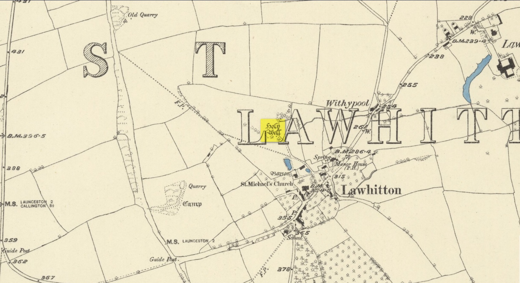
Highlighted on the 1882 OS-map several hundred yards north of St. Michael’s church, this site seems to have fallen back to Earth as no remains of it have been found in recent visits. It was described in Charles Henderson’s (1914) notes as the “holy well at Barton Farm”, and was visited by J. Meyrick (1982) in April of 1980, who told that it could be found by taking “the track immediately east of Lawhitton church which runs through the farm of Mr Lancaster… After going through the yard proceed ¼ mile down track to the valley where you reach a stream and the Well is on the right.” It was sought after by Cheryl Straffon (1998) but following her visit to find the Well she told that “there was nothing now to see except a kind of natural basin by the small bridge.”
References:
Henderson, Charles, Notebooks of Parochial Antiquities, Unpublished MS 1914.
Meyrick, J., A Pilgrims Guide to the Holy Wells of Cornwall, Falmouth 1982.
Straffon, Cheryl, Fentynyow Kernow: In Search of Cornwall’s Holy Wells, Meyn Mamvro: Penzance 1998.
Acknowledgements: Big thanks for use of the early edition OS-map in this site profile, Reproduced with the kind permission of the National Library of Scotland.
Tumulus (destroyed): OS Grid Reference – TQ 861 862
Archaeology & History
Somewhere beneath the modern housing estate immediately east of Chalkwell Park was once a large prehistoric burial mound. It was included in Wymer & Brown’s (1995) archaeological gazetteer (albeit at the wrong spot) without comment, but their reference led me to an early description of the place by Philip Benton (1867) whose description gave us the best info we have of the place. He wrote:
“To the east of the present mansion, at the north-west comer of a field called Fishponds, is a tumulus or mound, probably Celtic. This was first opened about thirty years ago, when bones, a few coins, and a piece of chain were discovered. Since which period about eight feet of earth has been removed from the summit, when more bones were found, but as they were not inspected by any one competent to give an opinion, it is impossible to say whether they were those of man or beast. The mound is still about four feet above the surrounding soil, and would probably repay further search.”
Wymer and Brown listed the site as being an “early Bronze Age” monument.
References:
Benton, Philip, The History of Rochford Hundred – volume 2, Harrington: Rochford 1867.
Wymer, J.J. & Brown, N.R., Excavations at North Shoebury, East Anglian Archaeology: Chelmsford 1995.
Holy Well (destroyed): OS Grid reference – TQ 3337 8245
Archaeology & History
Holywell Lane on 1877 map
First described at the beginning of the 12th century as “fons qui dicitur Haliwelle“, these sacred waters were thereafter described in a variety of documents before eventually, in 1382, giving its name to the road on which it was found. When the topographer John Stow (1603) described the well—along with those of St. Clement’s and Clerken Well—it was once “sweet, wholesome, and clear” and “frequented by scholars and youths of the city in the summer evenings.” However, in his day it was already in decline, as he told that the “Holy well is much decayed and spoiled, with filthiness purposely laid there, for the heightening of the ground for garden plots.”
The history of the site was mentioned in John Noorthouck’s (1773) survey, where he told us:
“In the parish are two prebends, and part of a third, belonging to St Paul’s cathedral, in the city of London: The first dominated by Eald-Street, or Old Street, received that appellation from the Saxons being part of the Roman military way: the second, which had been a separate village for many years, by the name of Hochestone, vulgarly Hoxton, likewise itself to be of a Saxon origin: the third called Haliwell, had its name from a vicinal fountain, which, for the salubrity of its water, had the epithet Holy conferred on it.
In King John’s Court, Holywell-lane, are to be found the ruins of the priory of St. John Baptist, of Benedictine nuns, founded by Robert the son of Gelranni, prependary of Haliwell, and confirmed by charter of Richard I in the year1189. It was rebuilt in the reign of Henry VII by Sir Thomas Lovell, knight of the garter; who was there buried: and the following ditty was in consequence painted in most of the windows.
“All the nuns of Holywell,
“Pray for the soul of Thomas Lovell.”
The complete demise of the well occurred in the early part of the 19th century and efforts to locate its original position have proved troublesome. Indeed, the modern Holywell Lane would seem to be little more than an approximation of its whereabouts. It was an issue explored at some length in the great A.S. Foord’s (1910) magnum opus, who wrote:
“In recent times efforts have been made to locate the well, and some of the results communicated to Notes and Queries. A Mr. R. Clark drew attention, through the medium of that publication, to an article in The Builder of September 19, 1896, which states that ”the ancient holy well should be looked for in the area between Bateman’s Row and New Inn Yard and behind the Board School in Curtain Road, that is to say, west of New Inn Street.” This is all very circumstantial, but the writer bases his statement on the survey by Peter Chassereau, taken in 1745, in which the supposed position of the well is marked by a cross and the words “Ye well from which the liberty derives its name.” It should be borne in mind however that, as pointed out by Colonel W. F. Prideaux, Chassereau did not make his survey till more than two hundred years had elapsed from the date of the dissolution of the Nunnery (1539); the position of the well could therefore have been only a matter of tradition. Another contributor to Notes and Queries (8th Series, May 22, 1897), quotes an article in the Journal of the Royal Institute of British Architects (vol. iv., 3rd series, p. 237), by Mr. E. W. Hudson, who says that the well of the priory was situate on the south side of what is known as Bateman’s Row, but was formerly (before 1799) called Cash’s Alley, near Curtain Road. This agrees substantially with Mr. Clark’s statement. Mr. Lovegrove, writing in 1904, says: “The well itself is to be found in a marble-mason’s yard in Bateman’s Row, but is covered over.” The same writer notes that of the Nunnery buildings only a piece of stone wall about 50 feet long, in a timber yard at 186, High Street, Shoreditch, is now left.”
References:
Foord, Alfred Stanley, Springs, Streams and Spas of London: History and Association, T. Fisher Unwin: London 1910.
Gover, J.E.B., Mawer, Allen & Stenton, F.M., The Place-Names of Middlesex, Cambridge University Press 1942.
Lovegrove, G.H., “Holywell Priory, Shoreditch,” in Home Counties, volume 6, 1904.
Mills, A.D., A Dictionary of London Place-Names, Oxford University Press 2001.
Noorthouck, John, A New History of London, Including Westminster and Southwark, R. Baldwin: London 1773.
Stow, John, A Survey of London, John Windet: London 1603.
Sunderland, Septimus, Old London Spas, Baths and Wells, John Bale: London 1915.
Wood, Alexander, Ecclesiastical Antiquities of London, Burns & Oates: London 1874.
Holy Well (lost): OS Grid Reference – SP 66 59 (approximate)
Archaeology & History
In George Baker’s (1822) massive regional history work he spoke of the village being “well supplied with springs, one of which, called Holywell, is medicinal.” But it would seem to have fallen foul of that thing called progress, as no one has spoken of it since then. When the Northampton historian, Beeby Thompson, looked for the site early in the 20th century, his enquiries drew a blank and he reported simply that “at the present time no one in the village appears to know of such a well.” A field-name survey of the area may prove worthwhile…
References:
Baker, George, The History and Antiquities of the County of Northampton, J.B. Nichols: London 1822.
Healing Well (covered): OS Grid Reference – TQ 6000 3963
Archaeology & History
Shown on early OS maps as a chalybeate spring, the denuded remains of this site can still be seen in Dunorlan Park, between the tearoom and the lake, where the spring can be seen on the left beneath a large tree. It was first described in John Britton’s (1832) famous account of the area, who told us:
Site shown on 1872 map
“There is a spring, called Burnt House Spring, situated in a little dell, in a romantic spot to the right of the road leading from Tunbridge Wells to Pembury. It is a good chalybeate, and the iron is in a state of carbonate. This spring rises rapidly into a stone basin, placed in the centre of a circular excavation, about ten feet in diameter and six or eight feet deep, which is bricked round, and with the remains of stone steps leading down to the basin at the bottom. This spring, therefore, has clearly been, at some time, made use of as a medicinal water. It was accidentally discovered choked up with rubbish. The country about Tunbridge Wells abounds with springs of this character.”
The spring was cleaned up some time ago and its waters rise in a square stone-lined chamber—accessed by four stone steps—into a circular stone basin, before flowing down a short channel and into the drains. I’ve no idea whether or not the water is still drinkable.
References:
Britton, John, Descriptive Sketches of Tunbridge Wells and Calverley Estate, Longman: London 1832.
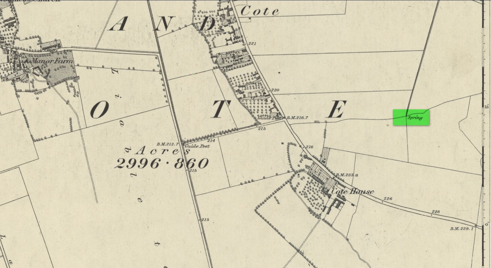
First mentioned as the field-name Holywellefield in the Court Roll of 1432, there is a possibility that this seemingly lost site still exists. It was mentioned briefly in John Giles’ (1848) old history book of the area where he told us that, “a field beyond Cote House on the road to Shifford is still called ‘Holy-well field’, (but) no legend has been recorded.”
If we go 400 yards northeast across the field on the other side of the road from Cote House, a “Spring” that was shown on the early OS-maps would still seem to be actively feeding a dyke that runs roughly north from here. This is probably the holy well that was described in those Court Roll records—and it still seems to exist.
References:
Gelling, Margaret, The Place-Names of Oxfordshire – volume 2, Cambridge University Press 1954.
Giles, J.A., History of the Parish and Town of Bampton, privately published: Bampton 1848.
Acknowledgements:Huge thanks for use of the Ordnance Survey map in this site profile, reproduced with the kind permission of the National Library of Scotland.
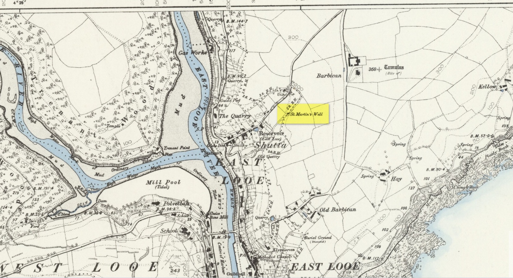
An early dedication to the St Martin of this well is from the 13th century, when referring to the “church of sanctus Martinus” in 1282, whose building is a half-mile to the north. The well itself is located on the old parish boundary, on the footpath today known as the North View.
In earlier days, the water from this site came “flowing out of a rock” giving birth to St Martin’s stream (Quiller-Couch, 1894). “It was much used by the villagers,” they wrote, “because of the excellent quality of the water; now it is covered in with an ordinary wooden lid, and is used to supply the town of Looe with water.”
Things hadn’t changed when Mr Lane-Davies (1970) visited the place, who was far from pleased at its status. “The spring,” he told, “has been enclosed in an ugly shed and the water piped away.”
Despite this, when Meyrick (1982) came here, he thought the site had “a romantic and grotto-like air” to it, but he was equally displeased by barbed wire preventing folk from easily accessing the waters and “spoilt by a certain amount of rubbish.” Unfortunately due to a dreadful accident here in 1993, when a young child fell into the waters and drowned, the site is now completely enclosed by railings to prevent this happening to anyone else.
References:
Bond, Thomas, Topographical and Historical Sketches of the Boroughs of East and West Looe, J. Nichols: London 1823.
Lane-Davies, A., Holy Wells of Cornwall, FOCS: St Ives 1970.
Meyrick, J., A Pilgrims Guide to the Holy Wells of Cornwall, Falmouth 1982.
Quiller-Couch, M. & L., Ancient and Holy Wells of Cornwall, C.J. Clark: London 1894.
Straffon, Cheryl, Fentynyow Kernow: In Search of Cornwall’s Holy Wells, Meyn Mamvro: Penzance 1998.
Holy Well (lost?): OS Grid reference – SX 2258 5311
Archaeology & History
This spot is where an old field-name has preserved the memory of an all-but-forgotten holy well, known as the “Holywell Ground.” Although it may have fallen back to Earth, there are two possible spots regarding its position: i) a spring that was marked on the 1882 OS-map at SX 2258 5315, and ii) a “Well” that’s shown on the recent OS-maps (SX 2257 5306). Hence, the grid-reference I’ve given to this place is the halfway spot between them both. (it has to be pointed out that the “well” on recent maps occurs right next to an old quarry, which are well known to bring forth water sources that were previously deep underground) Whether or not Sclerder Abbey—about 400 yards west of here and only built in 1843—had anything to do with the sanctifying this well, we can but guess…
There are numerous ways to get here from all directions: i) from the west-side of Wimbledon Common, on the Robin Hood’s Way A3 road, keep your eyes peeled for the small crossroad of Robin Hood Lane and Road, obivously taking the one into the park. Keep on the dead straight Robin Hood Ride path until your hit the carpark ¾-mile on; and from here, bear sharp left (NW) for 250 yards or so, where a small slope down on your left takes you there; or, ii) from Wimbledon village side on the A219 Parkside A219 road, where the War Memorial stands, head onto the Common along The Causeway, past the Fox & Grapes going on Camp Road, then up the Sunset Road towards the carpark. And then, once again go NW for 250 yards or so, where the small slope on your left takes you there. You’ll find it.
Archaeology & History
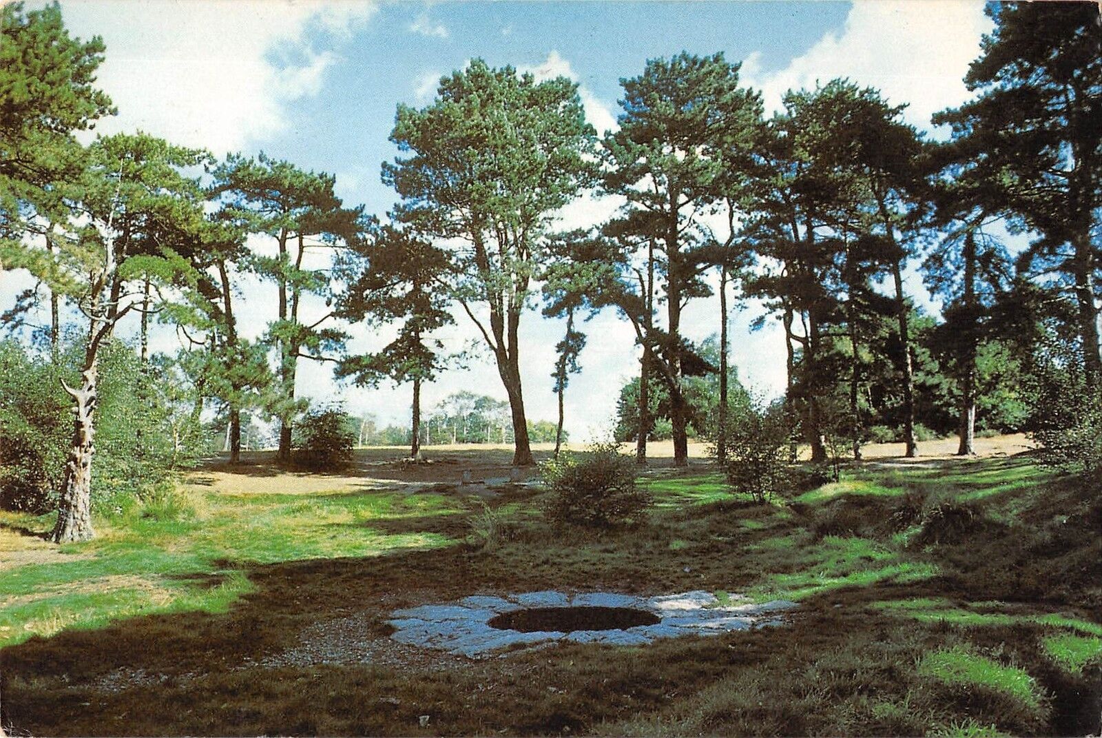
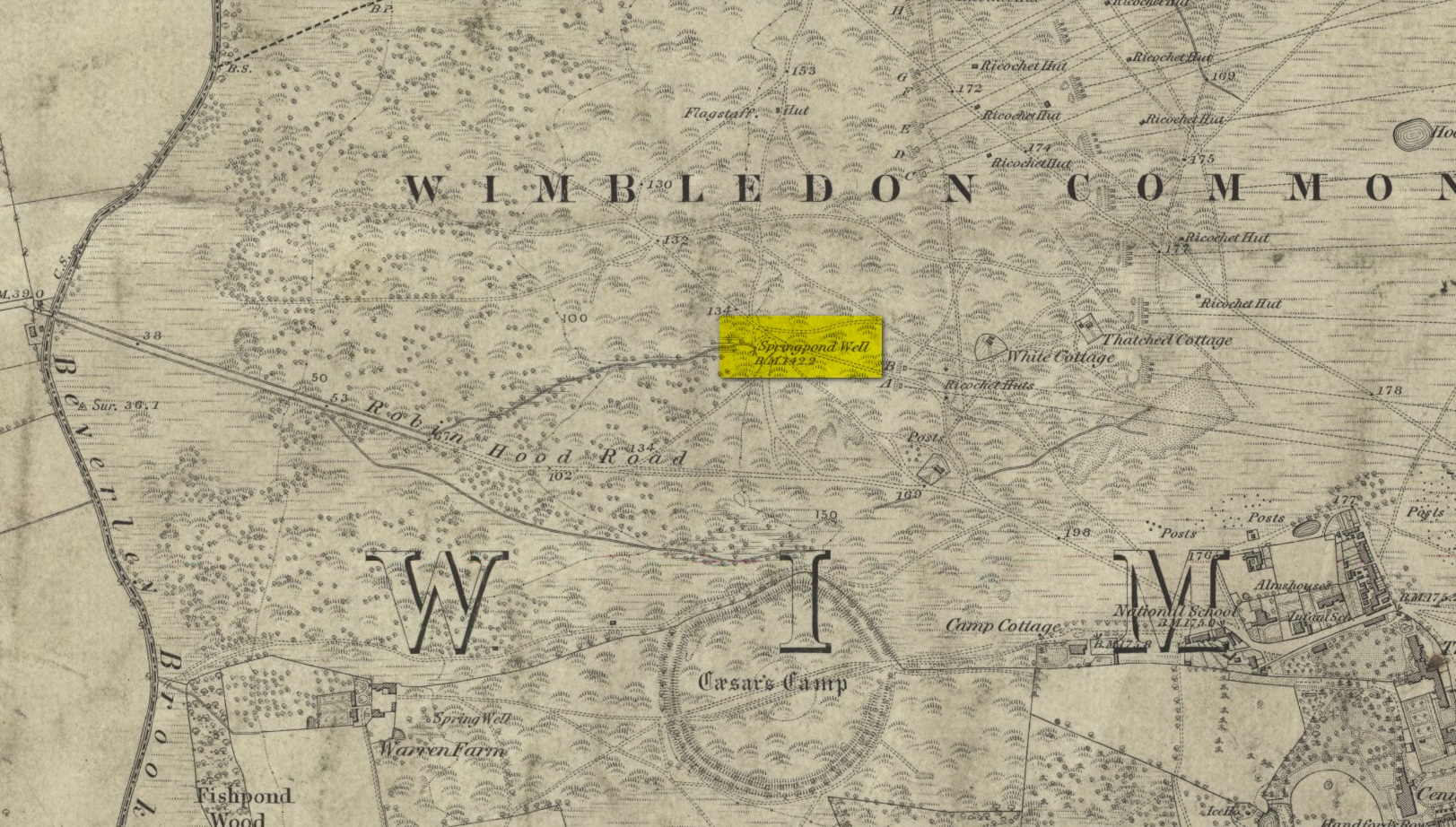
Described by William Bartlett (1865) as “the never-failing spring of water, improperly called the Roman Well”, its constant flow was severely tested in the great drought of 1976—and it kept on flowing. Only just though! It was highlighted on the early Ordnance Survey map with the plain name of the Springpond Well. The great historian and folklorist Walter Johnson (1912) gave us the best historical resumé of the site, telling that,
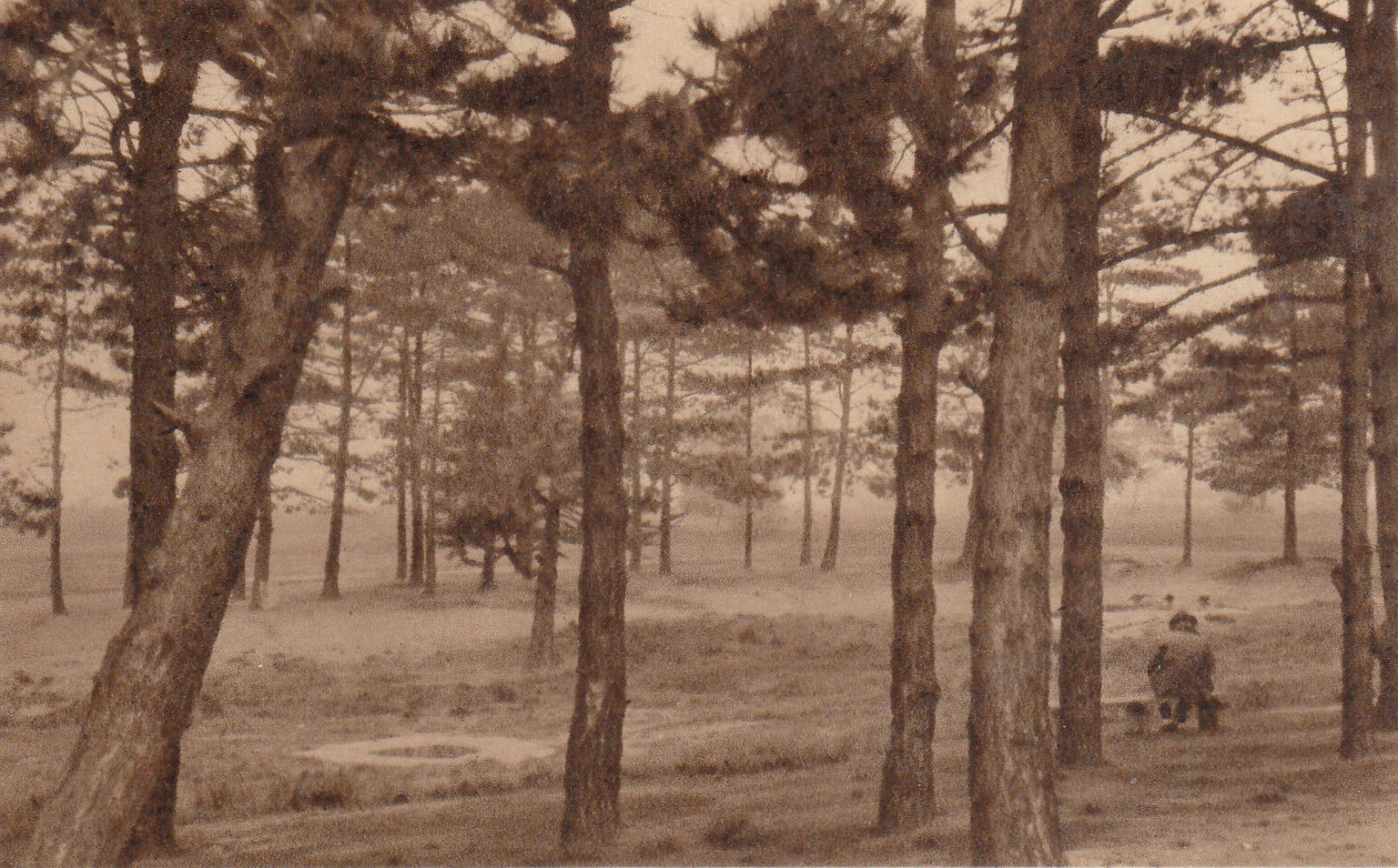
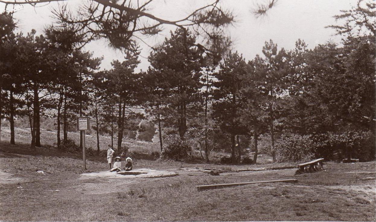
Caesar’s Well around 1900Caesar’s Well around 1911
“Caesar’s Well, formerly known as Robin Hood or Roman Well—the Springpond Well on the Ordnance Map—issues on the other side of the little watershed above mentioned, at a height of 149 feet O.D. The well lies in a little hollow, now ringed with Scottish pines. The gathering ground is the land to the east, rising to 198 feet O.D. This area is not large, but quite sufficient to maintain a permanent rill of pure water. The well, the waters of which once were deemed of special medicinal merit, was enclosed with brick in 1829, and, as the inscription tells us, refaced with granite blocks by Sir Henry W. Peek, M.P., in 1872. The outflowing waters descend to Brickfield Cottage, where they expand into a turbid duckpond; thence the course is through the yard behind the house, and along the north side of Robin Hood Road to Brook Cottage. During 1911 the “Well” proper altogether dried up, but water still issued from the stand spout a few yards below, which is supplied by an artificial boring and pipe that tap the spring at a depth of 18 feet.”
Site shown on the 1874 map
The proximity of this never-failing spring to the huge prehistoric enclosure of Caesar’s Camp just a few hundred yards to the south would indicate it was an important water source in Bronze Age times and, I’d hazard, would have been bestowed with some sanctity, as many such wells tended to be.
Folklore
James Rattue (2008) informed us that the name Robin Hood’s Well was known here in the 18th century prior to it being known as Caesar’s Well, but there seems to be no known relationship between Robin Hood and this site. However, a piece written in 1922 told that there was a lingering tradition that Julius Caesar encamped on Wimbledon Common in 51 BCE and that this folk memory was kept alive in the lore of local children who devoutly believed that the great Roman Emperor drank from the cool depths of this well.
References:
Bartlett, William A., The History and Antiquities of the Parish of Wimbledon, Simpkin Marsall: London 1865.
Hughes, John L., “Caesar’s Well, Wimbledon Common,” in Source magazine, no.9, Spring 1989.
Johnson, Walter, Wimbledon Common – Its Geology, Antiquities and Natural History, T.Fisher Unwin: London 1912.
Rattue, James, Holy Wells of Surrey, Umbra: Weybridge 2008.
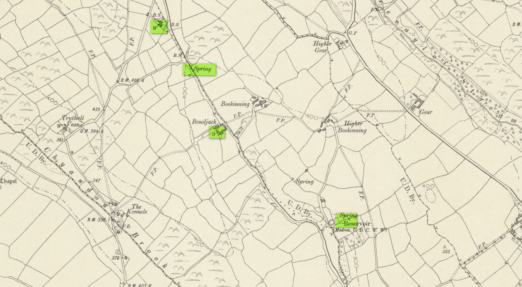
Sacred Well (lost): OS Grid reference – SW 4614 3259
Archaeology & History
It’s difficult to know what to make of this site: whether it was merely a healing well or whether it possessed greater esoteric functions. In all likelihood it was the latter as many so-called “wishing wells” in earlier centuries possessed oracular attributes. It’s also difficult to work out precisely where this well happened to be, as we know little about it apart from the singular reference of Quiller-Couch (1894), who told simply that,
“There was also a wishing-well in the Bone Valley; it is now only a small stream, and is not used for purposes of divination.”
Hidden spring on 1878 mapLine of wells on 1908 map
There were a number of wells along the Bone Valley road highlighted on the early OS-map, all of which may have been known to Quiller-Couch at the time, three of which appeared to have streams emerging from them back then: one just above Bosoljack (SW 4556 3319) and one below it (SW 4571 3292), each just off the roadside; but then a slightly more enticing one is hidden a little further down the lane and up the tinier lane to Higher Boskinning, in the trees on the right (east). Shown on the first OS-map as a simple “spring”, a small stream runs from it and then into the larger Bone Valley Brook which runs towards Penzance. The solace and quietude of this spot would seem much more favourable than the other two…. but my impressions may be wrong. It would be good if someone could find this old place…
References:
Quiller-Couch, M. & L., The Holy Wells of Cornwall, C.J. Clark: London 1894.
Russell, Vivien, West Penwith Survey, Cornwall Archaeological Society 1971.
Acknowledgements: Big thanks for use of the early edition OS-map in this site profile, Reproduced with the kind permission of the National Library of Scotland.