Ostensibly non-linear carved designs, generally assumed to be Bronze Age in date, but many originate in the neolithic period (some may indeed date back to 5000 BCE). Their central features are small rounded cup-markings, circles, semi-circles, curved lines (short, mid-length, and long), straight-ish lines, double- and multiple-rings, all in usually abstract design-forms. Their almost complete non-linear nature relate to non-egoic structuralisms, making them difficult to ‘intellectually’ grasp. Added to this is that no two carvings are the same. Although no direct ‘meaning’ can be ascribed to the carvings, many of them have a relationship with ancient notions of death and/or burial. In animistic terms, they relate to the spirit of rocks and other features of the natural landscape. They have very little relationship with alignment features (though exceptions in some megalithic rings have been found). Some modern writers allege positive relationships with water, but this ingredient (if tenable) cannot yet be said with any certainty: the idea should be forged onto animistic relationships with the land itself.
Easy enough to find once you’ve actually got to Wycoller. By car, the only real way to get here is from Colne, through the village of Winewall, and along the Wycoller road, which runs to a dead end. Once here, the old packhorse bridge with these cup-marks on it can’t be missed!
A weird one this! On the famous packhorse bridge close to the old hall, four of the stones have cup-markings etched onto them. It seems that at least three of the carvings are archaic; with cups on one of the stones being somewhat deep and may actually be medieval. But we simply don’t know…. A short article describing them was in the Bradford Cartwright Hall Archaeology Bulletin (1962) where they were equally as puzzled about them. In 1979, J.A. Heginbottom described them in his survey on the prehistoric rock-art of upper Calderdale. It’s possible that the stones on which the cups were carved might have been taken from a prehistoric tomb on the edge of the moor further up the valley from here.
Folklore
Just next to this bridge is another, much older one, known locally as the Clapper or Druid’s Bridge which perhaps has some bearing on the curious cup-markings. Legend tells that this older construction was so called “because legend has it that it led to an amphitheatre where the druids held human sacrifices” – and the field just up from here (to the southwest) was known as the Dripping Stone Field. Hmmmmm…..
References:
Bentley, John, Portrait of Wycoller, Nelson Local History Society 1975.
Heginbottom, J.A., The Prehistoric Rock Art of Upper Calderdale, unpublished report: 1979.
Jackson, Sidney, ‘Cup-Marked Stones at Wycoller,’ in Cartwright Hall Archaeology Group Bulletin, October 1962.
Takes a bit of finding this – but if you like your rock art, it’s worth the search! You can follow directions for the getting to the Man Stone then, when you reach it, look to the near horizon to the east. Get to the bottom of the sloping hillside where a large rounded boulder sits and walk up the slope about 10 yards. Look around here cos you’re very close.
Woman Stone carvingCarving highlighted in chalk
Alternatively, from the Askwith Moor Road, follow the path to the triangulation pillar on Shooting House Hill. Keep going for another 100 yards and check a small path to your left (south). Follow this down until you get to the top of the slope. Go to the bottom of the slope and look around!
This carving is best checked out in winter and early spring: if you go here in summer & autumn there’s bracken covering the entire site & you’ll never find it!
Archaeology & History
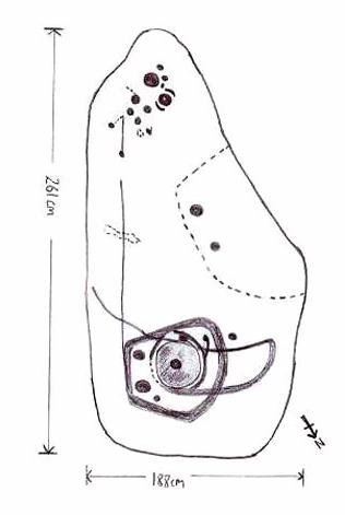
Drawing by Inmaculada Ibanez-Sanchez
This stone was first discovered by Graeme Chappell and I during one of our many ambling explorations here in the early 1990s and was first mentioned in my Old Stones of Elmet (pp.149-152). Marija Gimbutas would have loved this seemingly matriarchal-looking cup-and-ring carving, suggestive of many Mother Goddess images she found across Europe – hence its title!
Woman Stone design (after Boughey & Vickerman)
I don’t think that the old-school archaeological types would lower themselves to say such a thing, but as I aint one of them I’m quite confident in saying that this carving does seem to be a pictorial representation of a female figure: one of the earliest of its kind in the British Isles? (check its nearby male compatriot, the Man Stone – a distinctly human figure and one of the earliest of its kind in the British Isles) Very close by we are left with old place-name remnants pointing directly at the presence of pre-christian goddess remains in the mythic landscape – an issue I’ll expand on in the near future.
In the survey by more recent rock art students Boughey & Vickerman (2003), their illustration of the carving makes it look even more like an early female figure! (though I hear they don’t like people giving the carvings names – unless, of course, one of them lot names it…)
References:
Bennett, Paul, The Old Stones of Elmet, Capall Bann: Milverton 2001.
Boughey, Keith & Vickerman, E.A., Prehistoric Rock Art of the West Riding, WYAS: Wakefield 2003.
Gimbutas, Marija, The Language of the Goddess, Harper-Collins: San Francisco 1989.
Gimbutas, Marija, The Civilization of the Goddess: The World of Old Europe, Harper-Collins: San Franciscoo 1991.
You need to get to the eastern edge of Keighley Moor by taking the country road northwest out of Oakworth (one of two roads) and head to the end of Newsholme Dean Valley at Slippery Ford. You can park up at Slippery Ford at Morkin Bridge, then walk up the road for 250 yards, turning sharp left up the dirt-track. Walk along its wibbly route for another 250 yards and watch out for the large boulder in one of the fields on the left. That’s it!
Archaeology & History
Sketching the design
I came across this previously unrecorded carving in August 2006 after returning from an amble over the moors in the pouring rain and was fortunate to be able to make out the faint design, for, as with most cup-and-ring carvings, depending on the daylight conditions determines whether the carving is visible or not. Although some of the cup-marks on here are quite distinct, several are very faded and — as usual! — there are a number of dubious ones to work out!
Main design of cups & ring
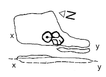
The carving gets its name due to the rock having a carved epitaph for an old local farmer — called William Walker — on its eastern face. There are also the letters “I.W.” carved on its sloping upper face, which looks typical of boundary mark notation, though this stone aint been on any boundary for at least 160 years (I aint checked earlier records). But much older on top of the rock we find perhaps as many as 20 cup-markings, which at first I first thought might be natural, but this was suddenly halted when I noticed in the bad light a large circle with several cups along it, inside of which were two other cups. On the southern edge of the rock it seems there may be another 3 or 4 cup-marks, one with a line running down (possibly natural). I took a couple of pictures when I first found it but they weren’t too well-defined. The ones here are a little better.
Artist’s impression by Angela HainsworthClose-up of ring, cups & lines
The main feature here is obviously the curious ‘ring’ above a small eroded basin, consisting of several cups, with two in the centre. On closer examination it appears that the ‘ring’ is in fact an unfinished circle with the two central cups having lines running from them to the incomplete ring, leaving a gap or opening at the bottom. The lack of other cup-and-ring carvings in the vicinity (apart from the simple Cob Stone, 750 yards away below Grey Stones Hill) is an oddity. A few more ventures onto the local hills are definitely required to see if anything else can be found!
Acknowledgements: With thanks to Angela Hainsworth for her assistance and sketch of the design.
Cup-and-Ring Stone (lost): OS Grid Reference – SE 062 253
Archaeology & History
Warley Edge Cup-and-ring stone
A rare find in Calderdale, as it’s only one of a very small number of full cup-and-ring designs — though its exact whereabouts remains elusive. From Heginbottom’s (1979) OS-reference, it’s close to a pretty built-up area, so may be destroyed.
He described it as a “large block with cup and ring markings, built into a dry stone wall,” 900ft above sea level. So where eactly is it…?
References:
Heginbottom, J.A., The Prehistoric Rock Art of Upper Calderdale and the Surrounding Area, YAS: Leeds 1979.
Follow the same directions to reach the Tree of Life Stone, then walk up the well-worn footpath up the slope for about 100 yards and, as you get to near the top of the hill, just watch out for a large-ish stone on the right. That’s it!
Archaeology & History
First described by Eric Cowling 1937, here we have what here looks like a faded cup-and-ring plus at least eight other cup-markings near Snowden Crags (though Boughey & Vickerman [2003] counted only 6 cups here). In more recent years it has become known as the “Fence Stone” due to its proximity the straight line of fencing which ran across the moor hereby. Cowling’s description of the site told:
Faded cup-and-ringCowling’s 1937 drawing
“The spur of hill separating Snowden Carr from Snowden Craggs is surmounted by a D-shaped enclosure which has a small level area in the highest corner. Here, on a triangular table stone amongst the heather, is a well-cut cup, ring and radial groove running to the margin of the surface. Four other cups appear to have no definite arrangement.”
He went onto say that “many of the boulders which surround this table are marked with cups.” They are indeed!
References:
Boughey, Keith & Vickerman, E.A., Prehistoric Rock Art of the West Riding, WYAS 2003.
Cowling, Eric T., “Cup and Ring Markings to the North of Otley,” in Yorkshire Archaeological Journal, part 131, 33:3, 1937.
Cowling, Eric T., Rombald’s Way: A Prehistory of Mid-Wharfedale, William Walker: Otley 1946.
Acknowledgements: A huge thanks to James Elkington for use of his photo for this site profile.
Various ways to get here. I s’ppose the easiest is from Dacre village. If you go just past Sunny House, take the footpath on your right & walk along it, roughly straight across a number of fields, until you hit the footpath known as the Nidderdale Way. The field you’re now in should be scattered with numerous rocks all over the place (if it aint, you’re in the wrong place), reaching down towards the trees. Walk straight towards the trees for another 100 yards and the carving is somewhere hereabouts under your nose! You’re very close! If, however, you decide to walk up the Nidderdale Way from Dacre Banks, the field you need is the one immediately to your right just before you reach the Monk Ing Road trackway. The Tadpole Stone (or Eastwoods Rough II carving) is in the same field, close to the Nidderdale Way path — check that out aswell!
Archaeology & History
This is a large carving I found in April, 2006, in the company of rock-art student Richard Stroud (who sent us the pictures). Twas in the midst of a fine day wandering about checking some of the ‘known’ sites in the area, when we happened across two or three previously unknown sites — and as the day wore on, just before we were gonna head for home, this little beauty poked the edge of its head out of the turf! It had the pair of us in near rapture, with numerous “Wow’s” and excitable expletives coming from our mouths! We’re easily pleased us rock-art doods — but then it is a beauty when you first see it.
We came here several times in the weeks following its initial discovery, and it seemed that on each visit, we found an additional aspect to the carving. It seemed to keep changing each time we came here — hence the name ‘Morphing Stone’!
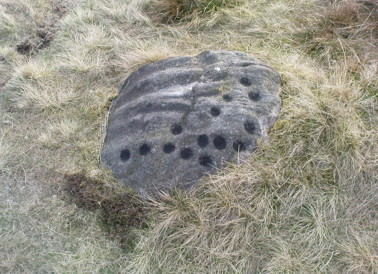
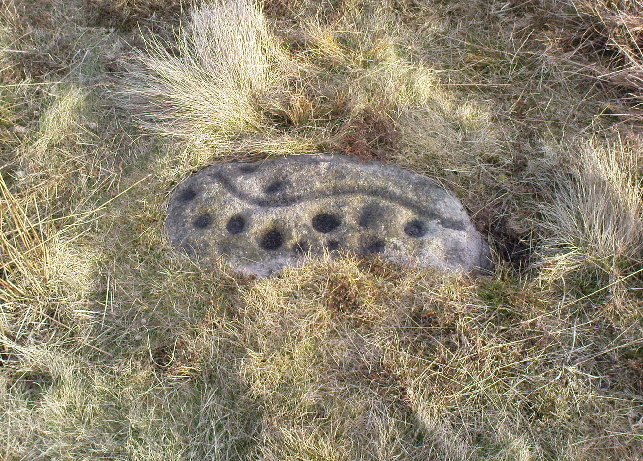
The prime feature in the carving is the very large oval-shaped ‘ring’ with huge carved bowl in the middle and several outlying cups-markings around it. Although it’s not plain to see in the photos, there’s a large tongue-shaped protuberance jutting out from one side of the main ringed feature. You can also see a small cluster of cup-marks on the top-right of the rock: from here — though it isn’t easy to see in the photo — a long straight line links up with the edge of the major central ring. Other lines run off on the top of the main feature and there are several other cup-markings on different parts of the stone. It’s obviously best to see the carving “in the flesh”, so to speak, to get a good impression of what it actually looks like. And, to those of you who might wanna venture up here, there are several others nearby.
A year or two after rediscovering the carving, rock art student Keith Boughey (2007) described the stone, saying:
“Measuring 2.61m from N-S and 1.88m from W-E at its greatest extent, the carved surface carries quite a complex design… At its N end is a large cup/basin with an approximate diameter of 25-30cm, surrounded by a ring that may or may not be complete: 2 cups have been incorporated into the ring on its N and W side. W of this ring a groove leads off S to a further possible cup. On the E side of the large central cup are 3 further cups of varying size. These motifs are all enclosed within a wide groove, which forms almost a dome pattern. Out of the ring, a further groove runs NW out of the design, bisecting the enclosing groove, curving round to form a handle shape before running back in towards the large central cup. The groove shows signs of continuing E towards the edge of the stone. Just outside the W edge of the enclosing dome is one well-defined cup. S of this, in a slight depression, are 2 further cups of differing size. A straight groove appears to run SW out of the enclosing dome shape on its E side towards further motifs on the stone’s S side. The groove may run into an area of cup marks, but there appears to be a break before it continues. When exposed, the carvings looked quite fresh and sharp, suggesting that they had remained covered for some considerable time – possible since antiquity or at least from a time in the prehistoric past when cup-and-ring-markings had begun to lose their significance and were no longer required to be visible in the landscape.”
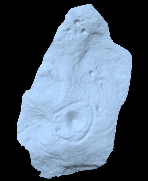
To those of you who like the new computer images of cup-and-rings, the three below are samples from a number of such images done after the stone had been discovered. Intriguingly, the long line running between the cluster of cups to the large cup-and-ring doesn’t show up too well; but the barely perceptible line running out, zigzag-fashion, from the large central cup-and-ring, shows up much clearer than when looking with the naked eye.
About 10 yards north of the old boundary stone on the Middle Ridge heading to the western end of Dryas Dike and about 10-15 yards east of the Middleton 453 carving, is this small rounded rock with between 12 and 15 cup-markings on its north and north-eastern sides. Several curious deep ridges run down across the rock which some ascribe as being man-made – but to me they’re Nature’s fine handiwork, although I may be wrong…
References:
Boughey, Keith & Vickerman, E.A., Prehistoric Rock Art of the West Riding, WYAS 2003.
Named boringly after the catalogue number given it in Boughey & Vickerman’s (2003) survey, this is another of the many small cup-marked stones clustered at the western end of the ridge between Delves Beck and Dryas Dike, below the moorland slope up to the Old Pike and Beamsley Beacon. It’s one of the more impressive of the carvings in this locale, albeit when it’s highlighted, as in the photos shown here (apparently done by one of the photographers in the Ilkley rock art group, I was told). It’s perhaps better seen when the sun is low and the stone’s been wet, which shows the shallow undulations of the cup-marks and wavy line that seems to split the main group of twelve cup-marks at the top northern side of the stone, from the two on its south side. There seems to be another wavy line carved above the main cluster, but this is difficult to make out.
References:
Boughey, Keith & Vickerman, E.A., Prehistoric Rock Art of the West Riding, WYAS 2003.
From the old T-junction in the hamlet of Langbar (where some doods have stuck up one of those ‘Private Road’ signs, typical of those Southern-types who bring their weird private land notions up here), go along the ‘private road’, keeping to the left until the road runs out. Then follow the small footpath above the house onto the moor, following the lines of walling along, crossing boggy streams, up the small hill and, once over the top and dropping down, keep your eyes peeled for the large boulder to the left of footpath, and a small scattered cairn on your right. It just a few yards past the cairn material!
Archaeology & History
Just 20-30 yards up the slope on the north side of Dryas Dike stream, to the left of the footpath, is a small, rounded flat stone with perhaps as many as eight cup-markings on it. Six seems more believable — though some of ’em on here (if not all) don’t look to have the air of authenticity that some of the other carvings hereabouts possess. One of the cups has a small ‘tail’ protruding from it. It’s a rather cute little thing! A small, unexcavated cairn lies in ruin about 10 yards east of the crude carving.
…and from another angle
On the other side of the footpath from here is that “large boulder” I mentioned above, which is reported by Boughey & Vickerman (2003) to have “one clear cup” marking etched upon it. They also report that archaeologists from “English Heritage report two cups and a possible short groove” on this rock. However none of the carvings reported here by either authority are man-made. All marks on the rock are completely natural and it needs omitting from any future archaeological survey.
References:
Boughey, Keith & Vickerman, E.A., Prehistoric Rock Art of the West Riding, WYAS 2003.
In the middle of the moors, with no footpaths close by. Unless you’re a rock-art freak I guess there aint gonna be too many people searching for it! From the Ilkley-to-Langbar road, take the track (Parks Lane) onto the moor where the road bends right. Follow it up for about a mile (though it doesn’t seem that far) and where the cup-marked stone at the edge of the wall where the spring appears (Middleton Moor carving 483), walk west (left) into the heather for a coupla hundred yards below Foldshaw Ridge. Look around!
This is one of a small cluster of carvings Richard Stroud found on a few average-sized stones prettty close to each other in April 2005 — and one which the West Yorkshire Archaeology Service told him couldn’t be there cos the region had already been surveyed. Hmmm…
Crap drawing!
Well, my first impression of this when I saw it was a absolute thumbs-up! Simple to look at, I know – but a bloody good little carving. It’s primary characteristic is that most of the ten or eleven cups occur on the vertical and near-vertical face, which aint too common. In traditional societies (though not all) where carvings occur on vertical faces, they’re deemed to be ‘male’ in nature (those on rounded smooth surfaces, female). The carving is well worth checking out — especially as there’s probably more to be found up here, hiding beneath ages of peat and heather.


")