Mentioned only in passing in the Becca and Aberford Enclosure Act of 1825, all remains of this site have gone. It was subsequently referred to by Edmund Bogg (1904) in his journey through Elmet as previously standing where the Roman road veered off to the northeast from the “new road”, as it was then. Bogg’s brief description told that from Nut Hill,
“A little distance south, where the old and new roads part, formerly stood a cross; Highcross Cottage keeps its memory green.”
References:
Bogg, Edmund, The Old Kingdom of Elmet, James Miles: Leeds 1904.
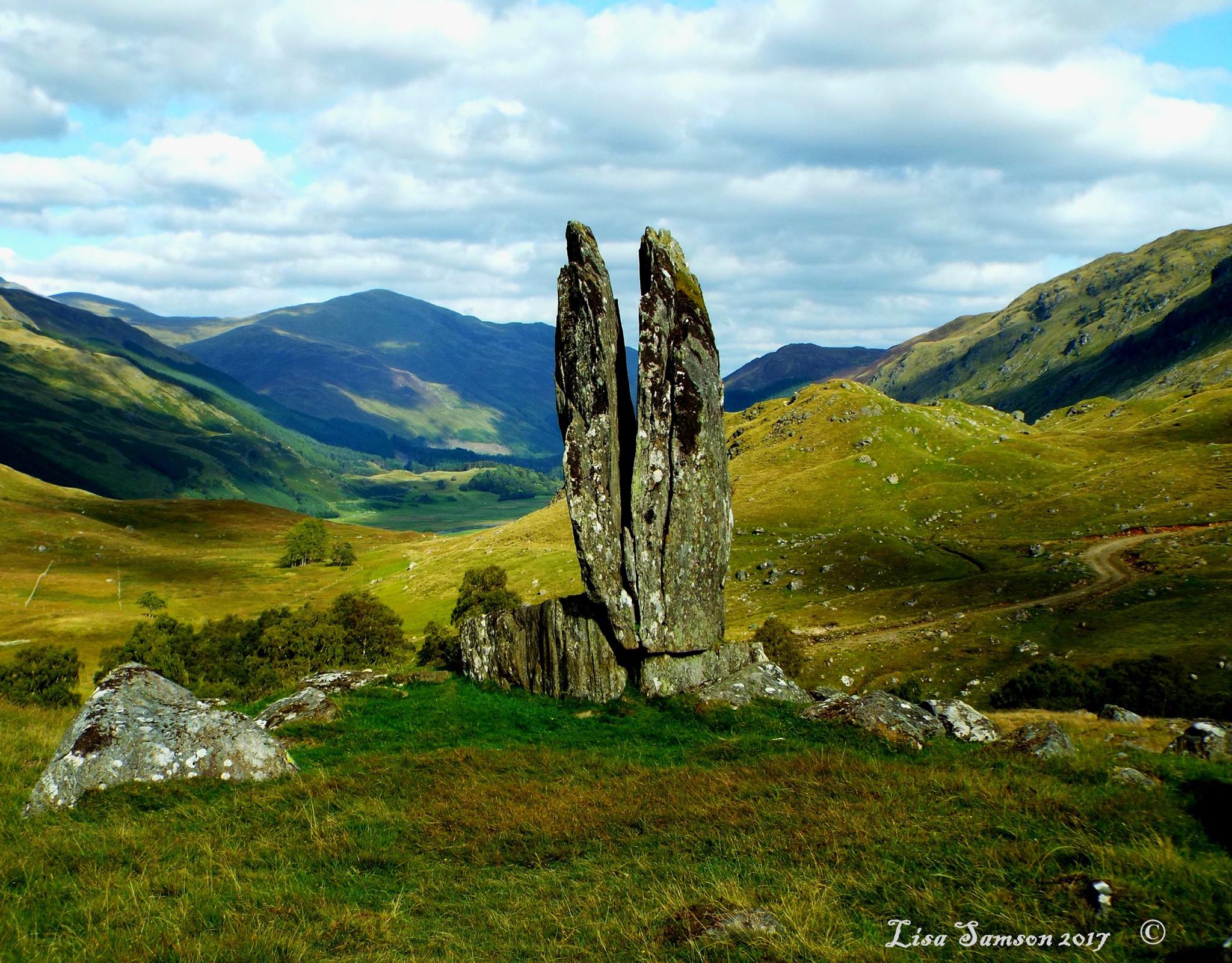
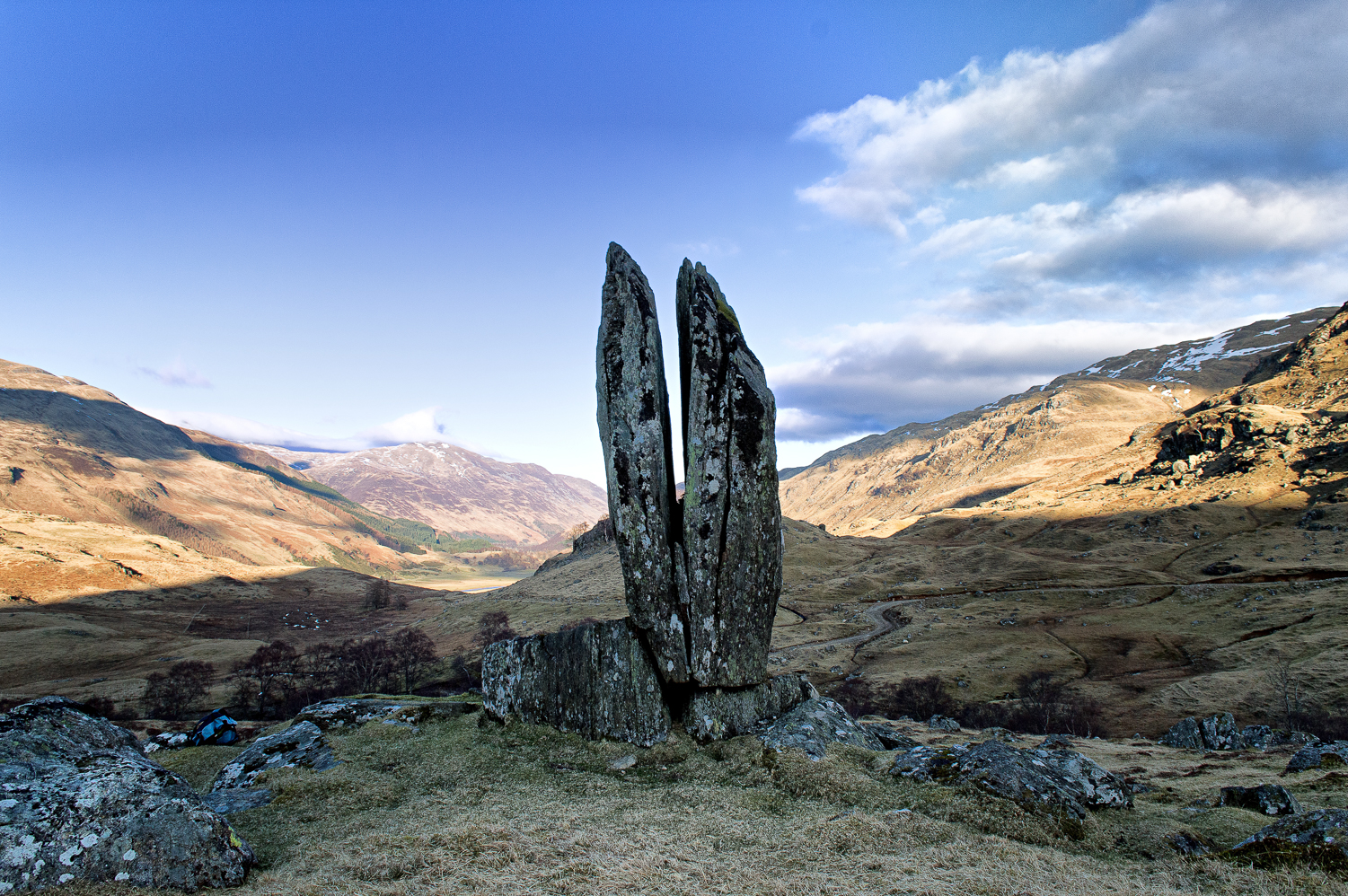
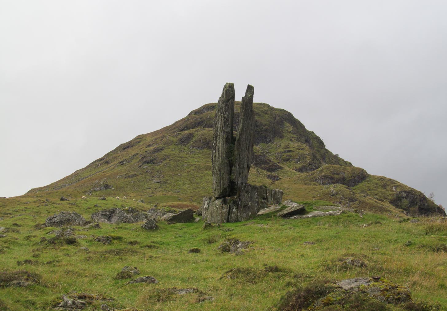
Clach na Sgoltadh, Glen Lyon (photo – Lisa Samson)
From Fortingall take the road into the legendary Glen Lyon. About 8 miles along, a short distance past the Adamnan’s Cross standing stone, you reach the tiny hamlet of Camusvrachan. On your left is a singular dirt-track, past some cottages. Go along here and over the river bridge until you reach the junction on the other side. From here, turn right and a half-mile on when you reach the farm and manor-house on your right, park up. From here you’ll see a track going uphill. Walk straight up and after a half-mile or so, keep your eyes peeled to your right. You cannot fail to see this impressive giant on the slopes above you!
Archaeology & History
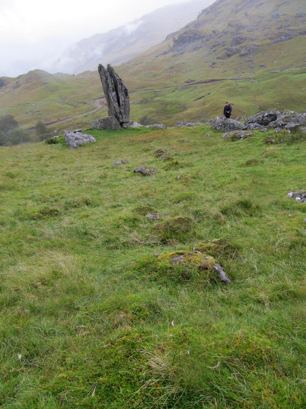
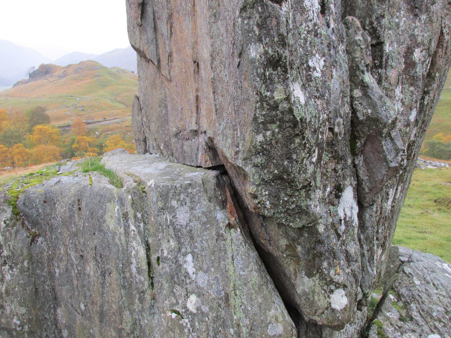
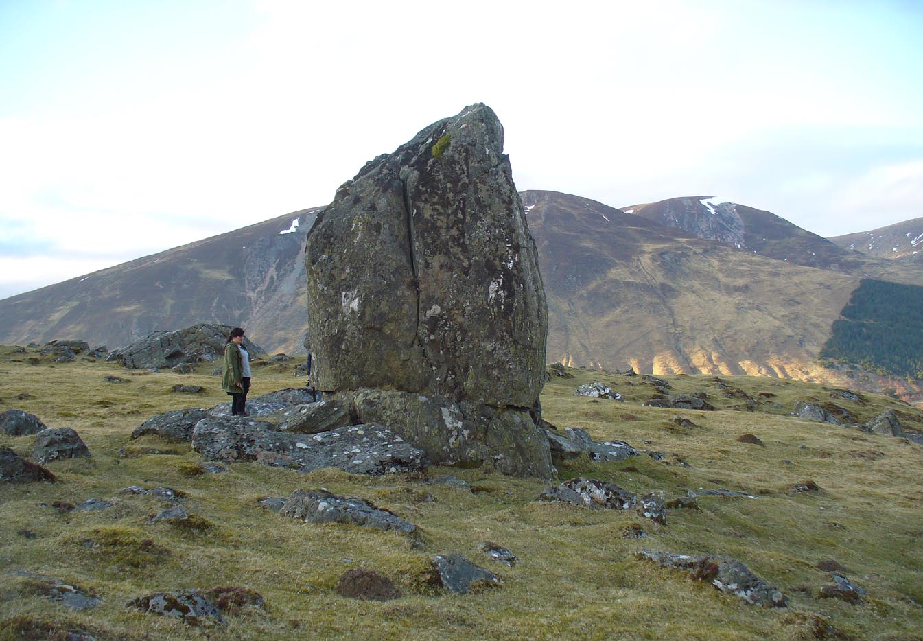
This is a truly mighty monolith! — a beauty no less! Standing upon a rocky ridge nearly halfway along the glen, the landscape it looks across is, without doubt, some of the finest in the British Isles. To our ancestors who, until just two hundred years ago peopled this and nearby glens in great numbers, this great stone would have been well known and had old myths told of it. Today we have only bare fragments.
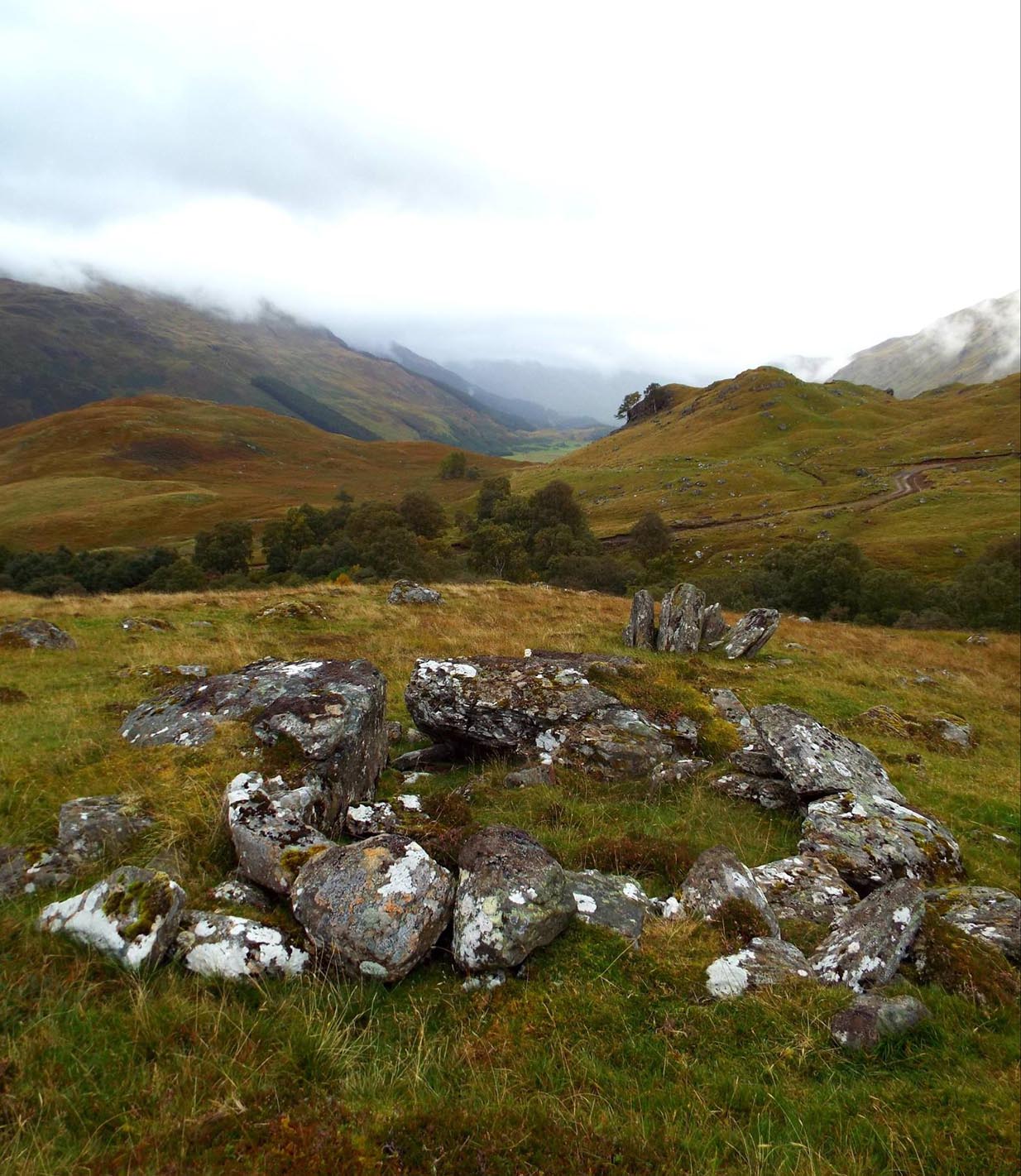
To give an ‘archaeological survey’ of any kind to this site would seem somewhat of an anathema, as it is generally deemed to be little other than one of Nature’s incredible creations. We’ll come to that in a minute. But what is quite certain is that a line of very old and very low-lying walling runs from up the slope and almost straight down to Clach na Sgoltadh. You can see it pretty clearly in the photograph below. The walling stops at the giant stone and continues no further downhill from the other side of the giant upright.
Walk diagonally down the slope about 30 yards south-east from the stone and you’ll find a small but distinctly man-made ring of stones, low to the ground, with an entrance on its northeastern side. It’s somewhat of a puzzle as it’s too small for a hut circle (I laid down in it in various ways and found you’d have to lie foetal all night if you were to use it as your own little abode), and it equally too small as an animal pen – unless it was for just one animal, which is most unlikely. The small circular construction wouldn’t seem to be prehistoric, but it would be good to know what it is.
So, we do have some very slight archaeological association with the site, albeit minimal, with the very ancient walling that leads to the stone being the most intriguing.
Small stone ‘hut’Low line of walling
The stone is generally attributed to be a geological creation. I certainly cannot say, as I have no expertise in the subject. However, in the opinion of just about everyone with whom I’ve visited this stone, I seem to be the only one who doesn’t think it’s man-made. A number of people have each insisted to me that it’s been stood upright by humans due to the quite distinct ‘squaring’ of the upright stone, particularly at the north-facing base. —and been seemingly bemused at my own lack of conviction. It does look as if it could have been cut and squared just as they all say but, let me repeat, I’m no expert at geology, and so all I can say is that I simply don’t know one way or the other. (useless prick that I am!)
“Perhaps a stone mason might know?” someone suggested—which seemed to be a good idea. Certainly a stone mason would surely be able to tell if it had been cut and dressed at the base, where it fits into the large earthfast rock….
Cue Chris Swales: a reputable stone mason from near Skipton, North Yorkshire. Chris and his friends took a week long whistle-stop tour in and around the Loch Tay region and thought they’d visit Glen Lyon. I heard about this and so asked him if he’d have the time to visit this stone giant and, if possible, let us know his opinion: is is a natural obelisk, or does it look to have been erected by humans? I told him my opinion and that of the geologists who give it an entirely natural provenance.
It was a few weeks later when he got back in touch and I asked him if he’d been up to Clach na Sgoltadh.
“I did,” he said. “it’s bloody impressive Paul. And what a gorgeous landscape too. I’d love to go there again.”
“Aye, it is Chris. And what did you think of the giant stone then? In your opinion is it man-made or natural?”
“Well I don’t know for certain Paul,” he said, “but in my opinion I’m 95% sure that it’s man-made.” He said it plain as day, just like a typical daan-to-Earth Yorkshireman. Chris isn’t into any the energy ley-line stuff, so his words carry more weight than those who wanna spice-up a site by projecting their own beliefs onto a place. As a result, I was somewhat taken aback by his words.
“What—are you sure Chris?!” I asked.
Cut & dressed stone?
“Like I said – I’m not 100% sure Paul. I can’t really say it 100% – but I’m 95% certain that people cut and dressed the base of that stone and put it there. If it’s natural, then I’d like to know how they think that’s the case. I’m willing to be shown otherwise, but in my opinion, on the whole, it’s man-made. People stuck that stone there!”
It would be great to get another stone mason’s opinion about this site; and it would definitely be good to read a geological viewpoint, but I’m not aware of any papers regarding this stone. (does anyone know of any?) For my part: I can only reiterate that I’m ‘unsure’ whether or not this is man-made. I’m simply not qualified to give an objective opinion.
The curious thing is: if this isNature’s handiwork, then it would have been held in greater reverence to our ancestors than if it had been erected by people. Impressive creations of Nature were always deemed to be inhabited by genius loci of truly archaic potency. And in these deep impressive mountains, where the names of nature spirits still abound, this—without doubt!—would have been a place of considerable awe and sanctity. May it remain as such…
Folklore
Looking to the west immediately uphill and behind Clach na Sgoltadh is the rising rounded hill of Creag nan Eildeag. Legend has it that the great Celtic hero Fionn stood atop of this crag and fired one of his arrows at the stone, splitting it in half and leaving the stone as we see it today.
In a small cleft in the stone, quartz deposits can be seen along with an effigy of the Virgin Mary. However, the title of the Praying Hands of Mary is a modern attribution and has no historical or mythic veracity.
References:
Stewart, Alexander, A Highland Parish; or, The History of Fortingall, Alex MacLaren: Glasgow 1928.
Holy Well (destroyed): OS Grid Reference – SJ 836 985
Archaeology & History
Long since lost beneath the metal and concrete of modern times, even references to this forgotten place are very faint indeed. I expected to find something of it in Henry Taylor’s (1906) giganteum, but it even slipped through his considerable work; and, even where mention of it exists, it is only in passing. In William Proctor’s (1874) survey of early Manchester, he found deeds relating to the land and its early owners wherein the one and only mention of this well appears. It was located near the middle of the city centre, between the Law Courts and Manchester cathedral, in the area known today as the Parsonage Gardens on the east-side of the River Irwell. In earlier centuries this was the abode of a Christian minister, or parson, and the water from this well supplied his religious abode. Proctor wrote:
“Crossing over to the Parsonage, we find that, in 1780, one of its residents was Mr John Quincey, linen-draper, uncle to the English Opium-Eater. In the previous year Mr Quincey was married to Miss Martha Goodyear, of Ardwick. His residence was bounded, it seems, on the north and west by “a narrow street or passage called Black Fryars”; while on the other points of the vane his prospect is thus shown by an extract from a lease dated 1758: — “The orchard or garden plot adjoining the river; it is now fenced out with hedges and ditches.” Some years earlier mention is made of a summer-house, fruit trees, and plants in abundance, with “free liberty of way to the spring or well called the Parsonage Well.” In 1686, Thomas Heyrick of Manchester, gentleman, leased a “tenement and parcel of land abutting upon a messuage and garden heretofore in the possession of George Tipping, deceased, and now the dwelling-house of the warden [Richard Wroe] of the said College; bounded on the east part with the old Parsonage ditch adjoining to the tenement of Mr John Oldfield. Close by are or were the residences of John Nield, Hugh Boardman, Richard Haworth, Esq., and lately Jane Haworth, his widow.” A worn parchment proves the existence, in 1698, of “Parsonage Croft;” another of “Parsonage Pool;” and an order of the Court Leet, 1594, required the tenants to “go along the hedge-side, keeping the footway towards the Parsonage style, for their fetching of water from the river.” In 1765, an advertisement in the Mercury mentions “the sign of the Grey Horse in or near Parsonage Brow.” St Mary’s Church covers the ground once known as the Parsonage Green.”
Holy Well (destroyed): OS Grid-Reference – SE 100 254
Archaeology & History
This sacred site seems to have been destroyed sometime at the end of the 19th century. It was located on the great slopes heading up to Beacon Hill. In 1787, a property survey showed six houses here called Holy Well Cottages and on the 1852 OS-map a “Well” is highlighted at the bend in the pathway of the Old Bank as you’re going uphill, which is the place in question. On my last visit here about thirty years ago, its position was preserved under a large manhole.
References:
Heginbottom, J.A., “Early Christian Sites in Calderdale”, in Proceedings Halifax Antiquarian Society 1988.
The site of the well, which was in the historic county of Middlesex, appears to have been on the west side of the present Moorefields Road just north of the junction with St Loy’s Road. The OS reference is an approximation. The restored circular well house to the south of the High Cross at the High Road – Philip Lane junction now popularly known as ‘The Old Well’ or ‘The Old Pump’ by Tottanham Green has been referred to as being ‘St Eloy’s Well’ but this is not the historic well described in this profile.
Archaeology & History
Likely position of the well on the 1873 6″ OS Map
The well was still in existence in 1876, but by the time of the revision of the OS map around 1894, it had been destroyed following building of the Great Eastern Railway’s Enfield branch line and the construction of terraced housing along the new St Loy’s Road.
So where was the well? The 1873 6″ OS map shows a field on parts of which the railway line and St Loy’s Road are now built, and a small area of water is shown in this field which is the likely position of St Loy’s Well on the eve of its destruction, when it was described as a dirty pool of water full of mud and rubbish. If this was the position of the well then it has now been completely built over…
It was described by Robinson in his 1841 History of Tottenham as being:
‘..in a field….on the western side of the High Road…surrounded by willows…it is bricked up on all sides, square and about 4 feet deep..’ ‘ In Bedwell’s time [it was]…always full of water, but never running over; the water of which is said to exceed all other near it.’.. ‘the properties of the water are similar to the water of the Cheltenham springs’.
Thomas Clay ‘s 1619 map of Tottenham, illustrated in Robinson’s book shows a field north west of Tottenham High Cross called ‘Southfeide at St Loys’. The Tottenham historian Wilhelm Bedwell described the well in 1631 as:
‘“nothing else but a deep pit in the highway, on the west side thereof;”….”it was within memory cleaned out, and at the bottom was found a fair great stone, which had certain letters or characters on it; but being broken or defaced by the negligence of the workmen, and nobody near that regarded such things, it was not known what they were or meant.’
This fair great stone with its ‘certain letters or characters that no one knew what they were or meant’ is intriguing especially in view of the well’s proximity to the Roman Ermine Street (Now the High Street). Were those mysterious characters spelling out an undecipherable Latin inscription on a Roman stone? We shall never know, but it hints at a pre-Christian origin or veneration of the well. Another hint is that before the Reformation there was nearby a chapel of St Eloy known as the Offertory*, which may have been originally built to ‘Christianise’ a pre-existing heathen sacred spring. The Roman origins of the well are also hinted at (probably erroneously) by W.L. Bowles in 1830, writing of a ‘Druidical Tour’ that one Sir Thomas Phillipps undertook on the continent, first quoting Phillipps before adding his own conclusion:
‘“Near Arras in France, are found the mount of St. Eloi and the very name of a place, Tote. I have no doubt Druidical remains will be found there, if this be not the very country of Carnutes.”
Now let me observe, that Tote is Taute —Tot—Thoth, latinized into Tewtates by Lucan, &c. the chief deity of the Celts. St. Eloi is neither more nor less than the Celtic word Sul, turned into the Greek the Sun; and Elios, turned into the Catholic St. Eloi, as at Tottenham, Middlesex, anciently Tote-ham, the ham of Taute or Tent, where is also the sacred well of St. Eloi, or ‘Helios’, the Sun !’
Saint Eloi / Eloy /Loy / Eligius, is the patron saint of those who work in the alchemists’ metal of the sun – goldsmiths! He is also the patron saint of blacksmiths, farriers, and all who earned their livings from horses, and lived from around 588 to 660 to become Bishop of Noyon and the evangelising apostle for much of modern day Belgium. His feast day is 1st December, and he had a widespread cult in mediaeval Europe, including England. In addition to being a healing well for humans, one writer hints that the well’s waters may have been employed for healing horses…they certainly would have drunk from it with its proximity to what is now the High Street.
Around 1770, an artist called Townsend (the sources are unsure as whether it was a Mrs or Mr) produced a romanticised drawing of the well, which was exhibited at the Royal Academy in 1770-1. It depicts a hermit beside the well (the Hermitage of St Anne stood to the south of High Cross prior to the Reformation) receiving an offering from a lady. It was engraved and sold as a print, and may be the only image of the well before its demise.
Folklore
In 1819 – 20, John Abraham Heraud wrote a poem about St Loy’s Well, set in the time of St. Edward the Martyr, (the late 970s), entitled ‘ Stanzas in the Legend of St Loy‘ of which the most relevant verses are;
‘TOTEHAM! the Legend of thine olden day, To the last note hath on thine echoes died; But the Bard’s soul still lingers o’er the lay, To muse upon thy transitory pride The pride of times that hath been — blank and void— When all was Nature, big with many a song Of Chivalry and Fame, with Love allied— But Time both changed the scene — now houses throng Where once was solitude — and people crowd along.
Where now thy WOOD, that spread its misty shade O’er twice two hundred acres? — past away! And vain its PROVERB, as the things that fade, Earth, sun, moon, stars, that change as they decay! The lonely CELL, the tenor of the lay, Its grove, which hermit tendance loved to rear; And, St. LOY, mouldering to Time’s gradual sway, Thy rites, thy OFFERTORY disappear;— Forgot thy SPRING OF HEALTH no votary worships there!
Forgot, neglected — still my harp shall dwell On thee, thou blest BETHESDA of ST. LOY! As Fancy muses o’er the vital WELL On years of storied yore, with grief and joy, Exults they were — weeps Truth should e’er destroy! Thrice I invoke the Spirit of the Stream With charm she may not question, or deny, And, like a Naiad, o’er the watery gleam She rises to my voice, and answers thus the theme:— ‘
Heraud wrote a further poem mentioning the well, his ‘Tottenham‘ of 1820, the relevant verse being:
‘St. Loy! here is this fountain—emblem pure Of chaste unostentatious charity— Never in vain intreated, ever sure ; Yet o’er the marge thy waters fair and free Ascend not, overflowing vauntingly, But in thy bounty humble as unfailing, In grief, disease, and sickness, visit thee. But part in joy, changed by thy holy healing To manhood, strength, and life, thy far renown revealing. There is thy offertory, and thy shrine, Simple, inartificial ; nor of fame, Nor any honour, save that it is thine, And all its glory centres in thy name !’
*Footnote – Brian Spencer’s book on mediaeval pigrim badges recovered by archaeologists in London refers (p222) to a distinct ‘London pattern’ of St Eloi badge – is this a hint that the Offertory was a local shrine to St Eloi where such badges were sold to pilgrims? Further research is needed to try to verify this speculation.
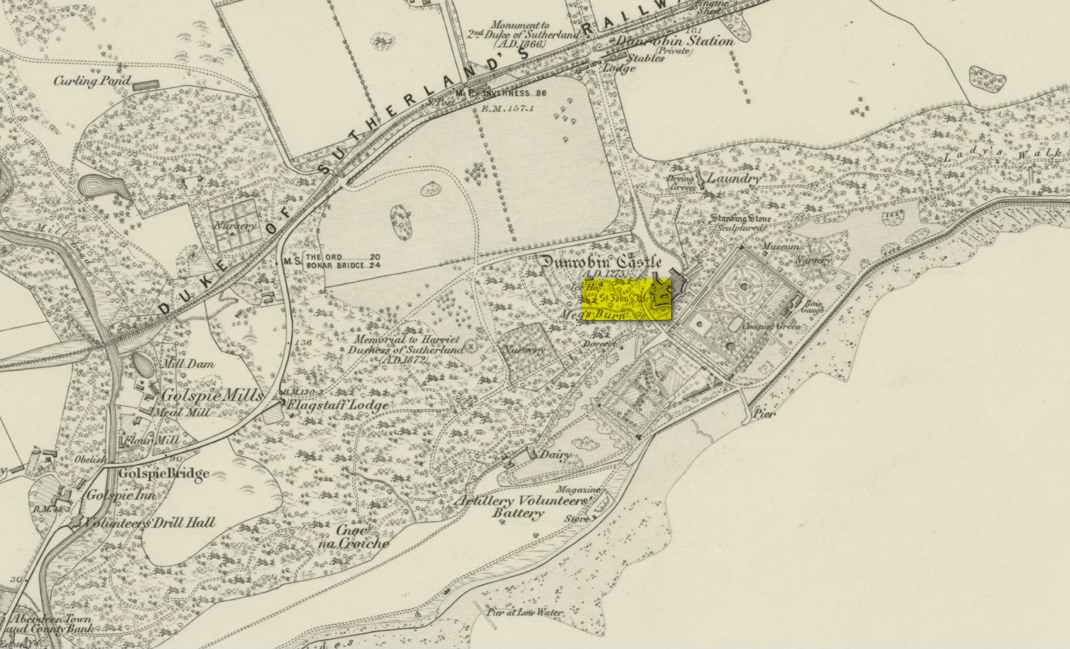
Very little has been written of this site due to the fact that little seems to known about it. A few of the usual ‘official’ on-line catalogues mention it but information on the site is truly scant. It is shown on the earliest Ordnance Survey map of the region and the same cartographers describe it in the Ordnance Name Book (1873), saying briefly how St John’s Well,
“Applied to a very deep pump well situated in the court of the ancient portion of “Dunrobin Castle”. No information respecting the dedication or origin of this name can be obtained in the District.”
But an earlier reference than this is cited in Fraser’s (1892) work, telling us that,
“In the midst of the court within the castle there is one of the deepest draw-wells in Scotland, all lined with ashlar-work, which was built and finished before the house was begun. The well was known as that of St. John. In the year 1512 sasine (i.e. delivery of feudal property) of the earldom and castle was taken at the well. At other times sasine was taken at the castle, at its gates, or near the well.”
Subsequent to this, we read in Cumming’s (1897) definitive folklore work of the region how,
“(it) looks as if there had been a chapel of St. John on Drumrabyn. In that case it may have been one dependent upon Kileain (=Kirk of John) on Loch Brora, which was only ½ a mile further than Kilmalin.”
Having not visited the castle, I’m unsure whether or not the well can still be seen. Does anyone know…?
Fraser, William, The Sutherland Book – volume 1, Edinburgh 1892.
Acknowledgements: Big thanks for use of the 1st edition OS-map in this site profile, Reproduced with the kind permission of the National Library of Scotland.
Take the Glenfarg road out of Bridge of Earn, cross the motorway and park at the layby past the bend. Go through the gate opposite and follow the track up to the telecoms mast, you can’t miss it..
Archaeology & History
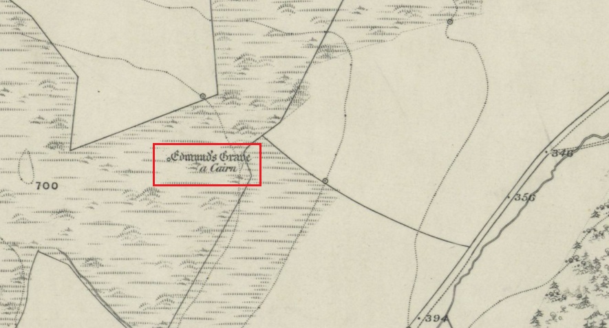
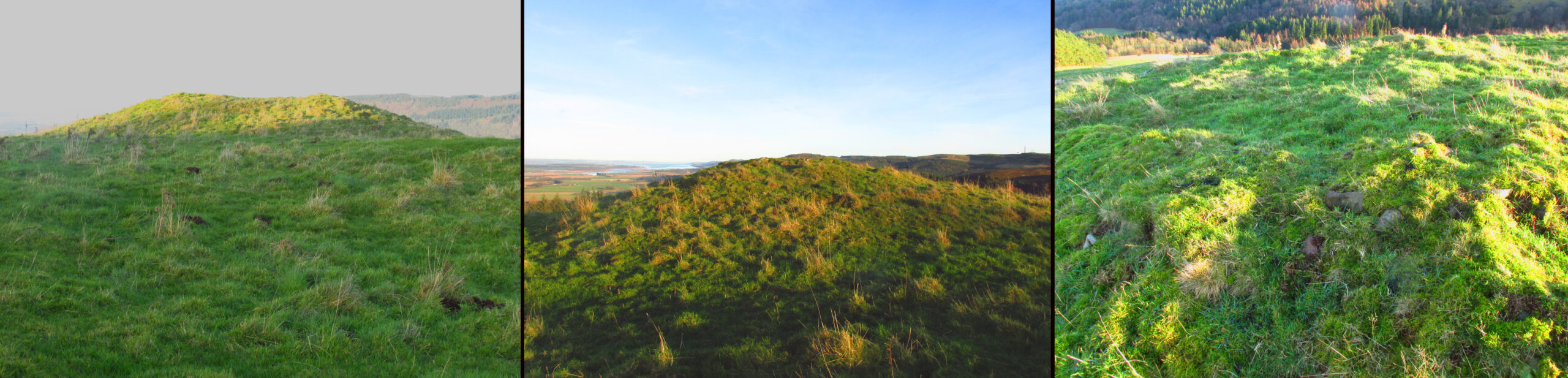
Shown on the 1866 OS Map
Visible from the lowlands below, it is described in the official listing as a cairn of prehistoric date, a funerary monument dating to the late neolithic to early Bronze Age. It is a broadly round stony mound, partially overgrown with turf on the north eastern (mid-summer sunrise) slope of Balmanno Hill, where it has extensive views over the surrounding country. It is 1.8m (6′) high, 17m (56′) across on the N-S axis and 16m (52′ ) on the E-W axis.
The top of the cairn has a depression in it: possibly the result of treasure-seeking long ago, but there is no evidence of any burial cist.
So who was ‘Edmund’? Was this a place of heathen ritual Christianised with the designation of St Edmund during the Anglo-Saxon incursions of the early middle ages, or the name of a local landowner? It is lost to history. The name ‘Balmanno’ can be interpreted as ‘Place of the Big Man’ – so have we an echo of a lost giant legend here in an area of Scotland where such legends abound, and long pre-date the construction of the cairn? Did later people name their local mythic giant ‘Edmund’?
An alternative meaning of ‘Balmanno’ is given by David Dow in the Old Statistical Account – the ‘Town of the Monk’.