From Threshfield, go up Skirethorns Lane for about 1/2 mile, where the lane takes a sharp right. Continue uphill for nearly 2 miles to a metal gate. Go through the gate into the fields on your left where you’ll see this pair of curious standing stones ahead of you (if you keep walking uphill in the same direction, you’ll reach the impressive Hammond Close enclosure above you).
Archaeology & History
There seem to be no references in either archaeology or geology texts about this site which, when you approach it and consider the prevalence of other prehistoric sites all round you, strongly suggests that they are either archetypal standing stones, or the remains of a collapsed cairn, with the surrounding mound removed. This is certainly the case at the Druid’s Altar or Bordley Circle visible a few hundred yards west of here, on the same grassland plain.
The stones alone, looking north
As you can see in the photos, the stones here are 4 feet tall and stand in isolation from the excess of neighbouring settlements and enclosures. A scatter of small stones—perhaps packing stones, perhaps the remains of cairn-spoil—is evident at the foot of the stones. It was initially thought that the uprights here could have been the remains of enclosure or settlement walling, as we find an excess of such remains on the hills here, but this isn’t the case. Other unrecorded prehistoric remains scatter this part of the countryside.
Follow the directions to reach the Little Skirtful of Stones giant prehistoric cairn. Once here, look for the singular rocks out of the many thousands which make up the giant cairn, mainly from the middle to the northern-half of the cairn, and you’ll find them amidst the mass!
Archaeology & History
Cup-marking near the centre of the cairn
Despite the task sounding difficult, it’s not too hard locating the cup-marked rocks within this giant cairn. As I recall there should be five of them, though the Boughey & Vickerman (2003) survey only list four and I only have photos of four of them as well…so I reckon age is probably getting to me at last! There could very well be more of them amidst this massive tomb. But we certainly can’t rely on the Boughey & Vickerman (2003) survey for the carvings at this site as they give the wrong grid references for each of the cup-markings listed, with them all being a kilometre east from the site of the tomb itself! Awesome! God knows what their cartographer was on when he did the profiles for these carvings! (there are plenty of spliff-butts scattered over this moor…..) Not only that, but the position they cite of the relative cup-markings within the cairn are also wrong.
Another portable stoneCup-mark at outer edge
But for those of you who like to know the archaeological data, here’s what was said: Carving 391a is a “small rock towards SW edge of cairn, with single worn cup”; but this stone is actually closer to the northern section of the cairn. Carving 391b was told to be a “small dome-shaped rock at extreme S edge of cairn with single, small clear cup at top of dome.” This again is more on the northern section of the cairn, away from the centre. Carving 391c was described as a “small oval, rounded rock at N edge of cairn, with single, broad, shallow worn cup.” Whilst carving 391d which was told to be a “small rock at SSE edge of cairn, with single small worn cup.” However, we have to take into account that any errors about their position may simply be down to the fact that the small rocks have been moved.
Smoothed cupShowing different rock-type
As you’ll see in the photos here, one of them is actually near the very centre of the cairn, with the cup-marking etched into the edge of the small rock itself. I’m not quite sure if this is the additional fifth carving in the cairn, or whether it’s one of those wrongly ascribed as being in another position. It’s hard to tell, as the local Ilkley Archaeology team don’t publish their findings and information on-line as they should do and unless you’re in their little club they’re hard to get info out of. So this will have to do for the time being I’m afraid. Also note how one of the cup-marked stones is of a rock-type different to the local millstone grit.
Folklore
The creation myth of the Little Skirtful itself tells that the giant Rombald (who gives his name to the moor) was in trouble with his wife and when he stepped over to Almscliffe Crags from here, his giant wife – who is never named – dropped a small bundle of stones she was carrying in her apron. Harry Speight (1900) tells us of a variation of the tale,
“which tradition says was let fall by the aforementioned giant Rumbalds, while hastening to build a bridge over the Wharfe.”
Variations on this story have said it was the devil who made the site, but this is a denigrated christian variant on the earlier, and probably healthier, creation tale. Similar tales are told of the Great Skirtful of Stones, 500 yards south.
The cluster of portable small stones with single cup-marks on them relates to traditions found in other cultures in the world where, usually, women would carry such items in their aprons and deposit them at or on the tomb, in honour of the ancestor or spirit known to be resident at the sacred site. The folklore found at the Little Skirtful (and Great Skirtful too) of Rombald’s wife dropping the rocks here and forming the giant tomb, probably derive from variants of this same honorary practice.
References:
Bennett, Paul, The Old Stones of Elmet, Capall Bann: Chieveley 2001.
Boughey, Keith & Vickerman, E.A., Prehistoric Rock Art of the West Riding, WYAA 2003.
Cowling, Eric T., Rombald’s Way, William Walker: Otley 1946.
From Cow & Calf Hotel head onto the moor above you, following the same directions to reach the ornately carved Idol Stone (and its immediate companions). Ahead of you on the same footpath, about 100 yards along, as it begins to slope up the hill further onto the moor, you’ll see a large upright pyramid-shaped stone, about 8 feet all, right at the side of the path. Y’ can’t miss it!
Archaeology & History
Deep cups & lines on top
Although ascribed as a cup-marked stone in usual surveys, the cup-markings on top of this rock are seemingly Nature’s handiwork. There is a possibility that cup-markings were carved into the top of the stone, many thousands of years ago, but due to the centuries of wind and weathering, we cannot in anyway assess the curvaceous bowls and lines running across and from the top of this rock to be artificial.
Folklore
The name ‘Idol Stone’ seems to have come about as a result of the judaeo-christian Victorian obsession of satanic idolatry in all things natural – which many of them still fear. Sadly there are no early accounts of practices of idolatry at this rock, until it was used by chaos magickians in the formative years of that Current in the 1980s.
References:
Bennett, Paul, The Old Stones of Elmet, Capall Bann: Milverton 2001.
Boughey, K.J.S. & Vickerman, E.A., Prehistoric Rock Art of the West Riding, WYAS: Leeds 2003.
Forrest, C. & Grainge, William, A Ramble on Rumbald’s Moor, among the Dwellings, Cairns and Circles of the Ancient Britons, W.T. Lamb: Wakefield 1868-9.
Hedges, John (ed), The Carved Rocks on Rombald’s Moor, WYMCC: Wakefield 1986.
Holmes, J., “A Sketch of the Prehistoric Remains of Rombald’s Moor,” in Proceedings of the Yorkshire Geological Society, volume 9, 1887.
Speight, Harry, Upper Wharfedale, Elliott Stock: London 1900.
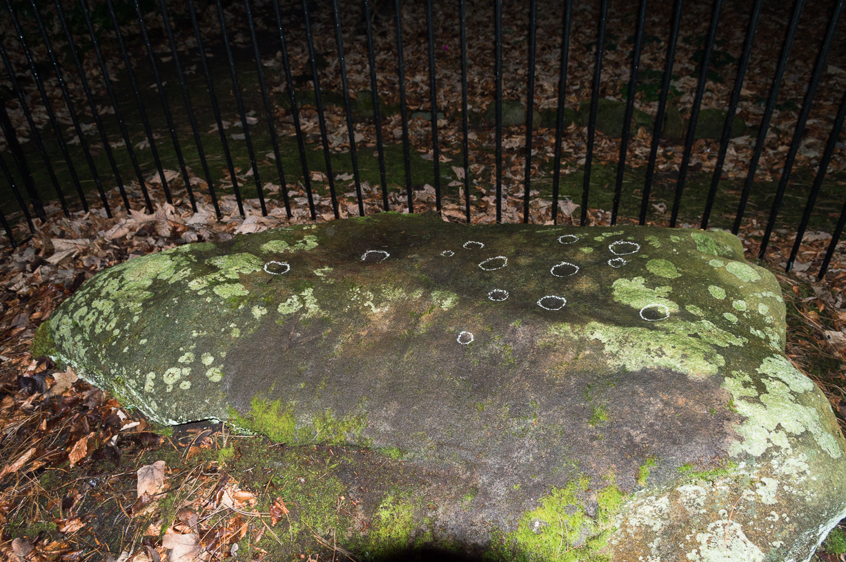
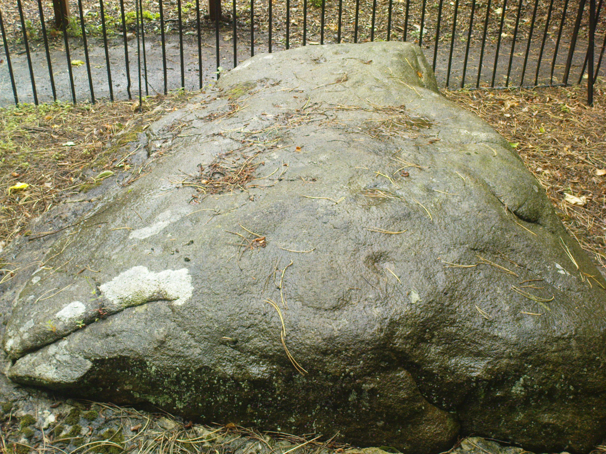
Come out of Ilkley/bus train station and turn right for less than 50 yards, heading left up towards White Wells. Go up here for less than 100 yards, taking your first right and walk 300 yards up Queens Road until you reach the St. Margaret’s church on the left-hand side. On the other side of the road, surrounded by trees is a small enclosed bit with spiky railings with Panorama Stones 227, 228 and 229 all therein: the least-decorated one on the left being the one we’re dealing with here.
Archaeology & History
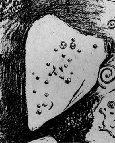
This is another of the caged Panorama Stones, found within the awful spiked fencing across from St. Margaret’s Church, just out of Ilkley centre. Originally located ¾-miles (1.2km) WSW of its present position in Panorama Woods (at SE 10272 46995), along with its petroglyphic compatriots in this cage, the carving was moved here in 1890 when a Dr. Little—medical officer at Ben Rhydding Hydro—bought the stones for £10 from the owner of the land at Panorama Rocks, as the area in which the stones lived was due to be vandalized and destroyed. Thankfully the said Dr Little was thoughtful and as a result of his payment he had some of the stones saved and moved into their present position.
Original location of stonesJ.T Dale’s 1879 sketch
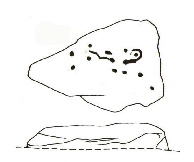
It was first described by the northern antiquarian and petroglyph pioneer, J. Romilly Allen (1879) , who saw it in the now-destroyed “rough inclosure”, as he called it, along with the other stones now in the same Ilkley ‘cage’. Its present position does it no justice whatsoever in terms of its original position. It was ostensibly a rocking stone: this seemingly trivial-looking boulder was sat on top of the much-cropped Panorama Stone 228 (a yard east of the three in this outdoor cage). Allen (1879) was fortunate enough to have seen the stone before it was uprooted, telling us how this topmost stone, “has eleven cups, wo of which are surrounded by single rings.” The modern archaeologist John Hedges (1986) told it to be in a “bad state,” with “very worn carvings, fourteen cups, one with partial ring and groove.” Its situation deteriorated further, as stated by rock art students Boughey & Vickerman (2003), who noted,
“medium-sized, roughly triangular rock, its surface recorded as in a bad state in 1986 and now (2002) even worse. Fourteen cups, one with partial ring, one groove.”
And its condition isn’t helped by its inaccessibility, when groups like the ‘Friends of Ilkley Moor’ or the local archaeologist should be at least annually cleaning this and the adjacent carvings. If they’re incapable, there are sincere people in antiquarian, history and pagan groups who would probably help out…
John Hedges 1986 sketchFaint cupmarks visible
In truth, this carving cannot be seen in isolation, nor merely reduced to a numeric catalogue in some rock art corpus. We must contextualize its relationship with the once much-larger multiple cup-and-ring stone on which it sat and then see it as it was in the landscape. Originally of course the rocking stone was Nature’s very own creation. As humans began migrating over and eventually occupying this once-wooded arena, the rocking stone became intimately related with animistic magickal rites and, over time, petroglyphs began to be etched upon the stone. Most probably the flat underlying rock surface was carved upon first, and a symbiotic relationship was forged between Earth’s surface and the small rocking stone, both of which were used in oracular and other rites. Over centuries, as the cups and rings on the earthfast stone grew, the mythic status of this small rocking stone allowed for the encroachment of carvings, and eventually cup-marks began to be etched upon it too. Later still, as the neolithic period moved into the Bronze Age, the people began to build a low-walled stone enclosure around this and the nearby multiple-ringed carving – similar to the multi-period enclosure at Woofa Bank and other sites on these moors. It was all a very long and gradual process.
In truth, the mythic status of this once-impressive site would have been maintained—in one form or other—well into the medieval period. But that’s another matter altogether…
Bennett, Paul, The Panorama Stones, Ilkley, TNA: Yorkshire 2012.
Bennett, Paul, Aboriginal Rock Carvings of Ilkley and District, forthcoming.
Boughey, Keith & Vickerman, E.A., Prehistoric Rock Art of the West Riding, WYAS: Leeds 2003.
Cowling, Eric T., Rombald’s Way, William Walker: Otley 1946.
Downer, A.C., “Yorkshire Archaeological and Topographical Association,” in Leeds Mercury, August 28, 1884.
Eliade, Mircea, The Sacred and the Profane: The Nature of Religion, Harcourt, Brace & World: New York 1959.
Hadingham, Evan, Ancient Carvings in Britain, Souvenir Press: London 1974.
Hedges, John, The Carved Rocks on Rombald’s Moor, WYMCC: Wakefield 1986.
Heywood, Nathan, “The Cup and Ring Stones of the Panorama Rocks”, in Transactions Lancashire & Cheshire Antiquarian Society, Manchester 1889.
Speight, Harry, Upper Wharfedale, Elliott Stock: London 1900.
Acknowledgements: With huge thanks to both Dr Stefan Maeder for help in cleaning up the stones; and to James Elkington for allowing use of his photos in this site profile.
First highlighted on the 1850 Ordnance Survey map of western Addingham in the same year William Howson described it, this large oval embankment sits on the eastern side of Counter Hill, amidst its gigantic earthworks, with attending tumuli, cup-and-rings, buried standing stones and other enclosures, like one huge prehistoric family of ancient sites! The earthworks here are in slightly better condition than the nearby ones at Marchup, as we can still make out the ditch marking the site.
There have been many literary visitors to the Round Dikes and its cluster of sites. One of the early ones was by the renowned historians and antiquarians, Forrest & Grainge (1868) who, in the second part of their ‘rambles’ exploring the prehistoric sites on and around Rombald’s Moor in the 1860s, told us:
“The Camp—known locally as Round Dykes—is of an irregular oval shape, the longest axis measuring over all 300 feet, and the shorter 250 feet. The trench outside the vallum is about 15 feet wide, and 4 or 5 feet in depth. The area is level, showing no indications of buildings or works of any kind. A feeble spring of water rises at one corner. The trench is regular and even, and does not appear to have ever been used as a series of pit dwellings. This work commands a large and splendid view of Wharfedale…”
Although suggested by Thomas Whitaker (1878) in his magnum opus on the history of Craven, to have been constructed by the Romans—who laid a road nearby on top of another earlier trackway—the site is obviously prehistoric. But when the late great Harry Speight (1900) ventured over for a gander at the end of the 1890s, he too thought it might be Roman. Finding the place to be “thickly overgrown with ling,” it was still in very good condition he said, telling “how its outline is almost as perfect as when made seventeen or eighteen centuries ago.” He continued:
“The form bespeaks a rather late date, having the characteristic angles, which makes the ordinary streight-sided rectangle into an octogan, giving it the appearance superficially of a round or oval. Its dimensions are based on the most approved form of castramentation, the length being one-third greater than the breadth, namely sixty yards wide and eighty yards long. A watch-mound has been thrown up within the southwest angle, and the whole camp defended with a double rampart having an intervening ditch. There is an old and excellent spring of water on the east sie of the camp; the site having been well chosen, commanding as it does, a splendid view of the valley and Street as it runs towards Olicana.”
By the time Eric Cowling (1946) came and looked at these earthworks, the opinion had truly swayed to seeing Round Dikes as a prehistoric site and not Roman. Cowling placed it firmly in the Iron Age! His profile of the site told:
“On the Western slope of Counter Hill and with a wide view of Wharfedale to the east is a second enclosure with five sides. Three of these form the three sides of a square and the remaining two bend outwards to enclose a spring on the lower eastern side. This enclosure is one hundred feet across from east to west and in the opposite direction the greatest measurement is seventy-three feet. The ditch is fifteen feet wide and varies in depth from three to five feet and there appears to have been an entrance in the eastern angle. There is an unfinished look about the earthwork; the inner and outer banks vary in height and are not continuous. The position is badly sited for defence, being overlooked from the higher ground to the west. The site would be very suitable for excavation, for it has been untouched by cultivation and is undisturbed.”
E.T. Cowling’s plan
And as far as I’m aware, no such excavation has yet been done here; and as we all know the local archaeologist is pretty poor when it comes doing such things round here, so god only knows when the real explorers and scientists will ever get their teeth into the place! However, the writers and archaeology consultants John and Phillip Dixon told that “a limited survey of parts of Round Dykes defined nine hut circles or parts of circles and possible hearth sites” in the 1980s. And although they ascribe the large earthwork as being Iron Age, the tumulus which sits near the southern edge of the enclosure is ascribed as Bronze Age.
It’s likely that the internal tumulus (a separate profile of it is forthcoming) was of communal and religious importance at Round Dykes. There was probably ritual function here within the enclosure, though only at certain times, when and where the ancestral spirits in the tomb awoke or were required to help the living. The spring of water on the eastern side of the enclosure, above the tumulus, was obviously not just the main drinking supply for the people who stayed here, but would also have had ritual importance (water, forget not, is tantamount to blood in ancestral cosmologies, and not a ‘commodity’ as the half-witted retards in modern culture have profaned it in their shallow beliefs). In the Lands of the Dead, water is vital for gods, spirits and the sustenance of the underworlds. (Eliade 1979) You might not think that; judæochristians might not think that — but the worlds of experience are much wider and deeper than the failing beliefs of atheists and monotheists…
…to be continued…
References:
Bennett, Paul, The Old Stones of Elmet, Capall Bann: Milverton 2001.
Bennett, Paul, The Prehistoric Sites of Counter Hill, Addingham, forthcoming 2013.
Cowling, Eric T., Rombald’s Way, William Walker: Otley 1946.
Forrest, C. & Grainge, William, A Ramble on Rumbald’s Moor, among the Dwellings, Cairns and Circles of the Ancient Britons in the Spring of 1868: Part 2 – Counterhill and Castleberg, W.T. Lamb: Wakefield 1868.
Dixon, John & Phillip, Journeys through Brigantia – volume 1: Walks in Craven, Airedale and Wharfedale, Aussteiger Publications: Barnoldswick 1990.
Eliade, Mircea, A History of Religious Ideas – volume 1, Collins: London 1979.
Howson, William, An Illustrated Guide to the Curiosities of Craven, Whittaker: Settle 1850.
Speight, Harry, Upper Wharfedale, Elliott Stock: London 1900.
Whitaker, Thomas Dunham, The History and Antiquities of the Deanery of Craven in the County of York, (3rd edition) Joseph Dodgson: Leeds 1878.
Follow the same directions to reach the Little Skirtful of Stones giant cairn. From here, walk 200 yards straight north until you hit the footpath at the top of the Woofa Bank crags. Walk left along the footpath and where it begins to slope downhill, note the large boulder right by the path and another 30 yards further on. Between these large rocks, turn left into the heather some 20 yards. You’re damn close!
Archaeology & History
Close-up of covered tomb
Rediscovered on March 17, 2012, this small untouched prehistoric stone cairn, measuring 3½ yards by 2½ yards across and about 1 yard tall, was found thanks to the moorland heather being burnt, which has stripped the covering vegetation from the monument. It rests just a couple of yards away from a small, almost dried-up stream, seemingly in isolation. There are scattered remains of medieval workings nearby, between here and the Little Skirtful—some of which have intruded upon and destroyed earlier sites—but this particular cairn has a prehistoric pedigree. An excavation here would be worthwhile sometime in the future; but the problem is, there’s so much neolithic and Bronze Age material all over this area, it’s hard to know where to start!
From Ilkley, take the same directions to reach the Haystack Rock; then walk east along the edge of the moor, past the Pancake Stone and keep along the footpath for more than 800 yards till you see the large cairn above-right of the footpath by about 20 yards, a short distance before you’d hit the Rushy Beck. Walk to the cairn, and then past it along the path (west) heading onto the moor for another 30-40 yards, checking the rocks on the ground thereby. You’ll find it!
Archaeology & History
Scruffy sketch I did of the stone, c.1982
Described in John Hedge’s (1986) survey as a “long, low, smooth grit rock, partly covered with heather. Seven clear cups”, we first found this carving when we were out bimbling on one of our hundreds of ventures on these moors as kids—on this occasion, as I recall, seeking out a cup-and-ring stone that Stuart Feather discovered and mentioned in an early Yorkshire Archaeology Journal. Less than a yard away from the one which Mr Feather described (the overgrown cup-and-ring stone no.375) was this curvaceous female rock, with seven simple cup-markings, mostly on its northeastern side.
When the heather is low in this area, you can clearly make out extensive remains of prehistoric walling 11 yards east of the cup-marked stone, running north-south. This eventually meets up with another line of walling that runs east-west and bends back around on the western sides of the carving about 20 yards away, seemingly encircling it. This enclosure will be described in greater detail at a later date.
References:
Hedges, John (ed.), The Carved Rocks on Rombalds Moor, WYMCC: Wakefield 1986.
Boughey, Keith & Vickerman, E.A., Prehistoric Rock Art of the West Riding, WYAS: Wakefield 2003.
Fom Burley train station, take the road uphill onto the moor edge, turning right for a coupla hundred yards where the road runs up the side of the Coldstone Beck. Walk up the stream until you hit the footpath that takes you onto the moor proper, on the righthand (west) side. Once on the level, note scatter rocks on the near horizon above you and the faded track that runs up towards them. Walk up here, keeping your eyes peeled for the small chair-shaped rock immediately left of the pathway. You can’t really miss it.
Archaeology & History
One of an increasing number of carvings that I’m finding have curiously not been included in the general rock art surveys of the region (Boughey & Vickerman, 2003; Hedges 1986). We first found this—Jon Tilleard and I—when we were foraging for such carvings in the 1970s and early ’80s and the scruffy drawing here is taken from one of my early notebooks (1981) that explored the archaeological remains on these moors.
Scruffy drawing of the stone, c.1982Close-up of cup-marks
The name of the stone comes from the slightly chair-like shape of the rock on which the blatantly obvious cup-markings can be seen. There are at least six of them, with a possible seventh near the top of the rock. Some curious eroded markings can still be to the left-side of the main cups, but I’m unsure as to their nature and they may be just geophysical. Above and around this rock are a number of medieval pit workings, quarrying and scatterings of other rocks, none of which have been found to possess cup-and-rings.
References:
Bennett, Paul, Of Cups and Rings and Things, unpublished: Shipley 1981.
From Burley train station walk up the road, turning right as you meet the moorland road. Go on for a couple of hundred yards until you run parallel with the Coldstone Beck stream. Walk up here for about 800 yards until the full moorland begins to open up ahead of you. Walk up the slope on your right (west) about 30 yards above the first of the ruined grouse-butts, towards the scattered mass of rocks before the small crags. The small standing stone on the edge of the ruins will catch your attention!
Archaeology & History
A fascinating small cairn which initially had us puzzling as to its very nature. Was it a cairn? Or was it a section of prehistoric walling? The former would seem to be the more likely, though an excavation here would obviously be helpful.
Standing stone, cairn-spoil & Coldstone valley to rearColdstone Cairn 2, looking west
Scanning the Earth hereby we found no surface remains, merely a section of disturbed ground where the small stones were placed and, obviously, removed in some number not too long ago. Stones from the cairn had obviously been robbed to construct the grouse-butts close by (something the local council officials seem to find acceptable). It would appear to be consistent in structure with many of the other cairns on this moorland, some of which are neolithic, but the majority date from the Bronze Age.* This particular cairn seems to be Bronze Age in nature.
The most defining element in the cairn is the small standing stone, less than two feet tall above ground level, within the southwestern area of the denuded tomb. No carvings could be noted on the stone, nor marks of any significance on the other smaller stones. Another cairn of similar age but in much better condition—the Coldstone Beck Cairn 01—can be seen when the heather’s burnt back, some 20 yards north.
* More than 100 singular small cairns exist around here, most of which have never been archaeologically assessed.
From Burley train station walk up the road, turning right as you meet the moorland road. Go on for a couple of hundred yards until you run parallel with the Coldstone Beck stream. Walk up here for about 800 yards until the full moorland begins to open up ahead of you. Walk up the slope on your right (west) about 40 yards above the first of the ruined grouse-butts, towards the scattered mass of rocks before the small crags. You’ll have to scout about a bit when the heather’s deep, but it’s there, hiding away!
Archaeology & History
Cairn in centre, looking east towards Otley Chevin
Like many prehistoric tombs on this moorland, this one has never before catalogued. Found about 20 yards north of Coldstone Beck Cairn 02, this larger and more complete megalithic structure, probably Bronze Age in nature, is of the traditional construction for cairns in this region: of small to medium-sized rocks that can be carried quite easily and deposited over a specified site, beneath which we’ll find either a ruined clay urn, or skeleton, or ashes.
The cairn measures just over 3½ yards in diameter east-west, and 3 yards north-south; it rises nearly a yard tall above ground level at the centre. Much of the internal construction has been compacted through centuries of soil and vegetational growth, with only the outer rocks of the structure being slightly loose. There are several other prehistoric cairns of the same size nearby, none of which have been recorded by the regional archaeologist round here.


")


