Rivock Enclosure, Riddlesden, Keighley, West Yorkshire

Enclosure:  OS Grid Reference – SE 0768 4414

Getting Here

Rivock Enclosure walling, looking north

Follow the directions to reach the small Rivock East Carving just on the level of the small moorland.  From here, walk less than 100 yards east, staying just on the edge of the moor, keeping your eyes peeled for the irregular shaped rocks running in lines roughly parallel with the footpath above the edge of the crags.

Archaeology & History

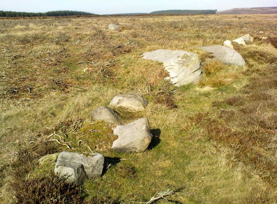
Recent explorations in and around the Rivock Edge area found, not only a number of undiscovered cup-and-ring stones, but the overgrown remains of an undoubted prehistoric enclosure on the ridge of moorland above the rock escarpment which has not previously been reported in archaeological surveys.  Much of the time the area is covered in deep heather, but thanks to this small section of moor being burnt back a short while ago, the lines of walling that mark the enclosure are there for all to see. It’s obvious that some sections of the old walls have been removed in the not-too-distant past for use in more modern walling and, nearby, old quarries and farming have probably been responsible for other destructive elements.

Easternmost line of Rivock enclosure walling

This enclosure is of a rough, rounded, scalene triangular formation, with the main piece of extant walling running roughly northeast-southwest.  The walling is typical of other settlements and enclosures in the region, probably Bronze Age in nature, Iron Age at the latest, with some natural earthfast boulders marking parts of the outline and many smaller pieces of rock and packing stones being added to build up the structure.  The same layout is found at other nearby prehistoric enclosures at Crow Well, Dumpit Hill, Snowden Moor, Woofa Bank and many others.

Of the larger upright stones in the Rivock Enclosure, several of them stand about three feet high, with some of them having been knocked down.  The longest line of walling, running roughly east-west, is less than 50 yards long; whilst the enclosure wall running roughly north-south on its eastern side is 30 yards long.  Much of the walling along its northern side appears overgrown and sections of it are missing.

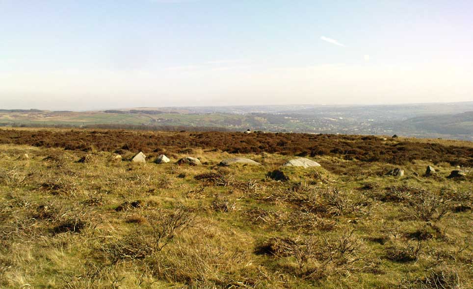
For a long time I puzzled as to whether there had been any settlements on this part of Rombald’s Moor, rich in cup-and-rings stones — and at last we find that there was at least one such site.  Forays back and forth across the level ground all around here failed to locate any other similar enclosure remains; but it may be that some have been covered (or were destroyed) in the adjacent forestry plantation to the west.  Further explorations by fellow antiquarians may prove worthwhile when the forest is cut down in the next few years.

© Paul BennettThe Northern Antiquarian


East Riddlesden Cross, Keighley, West Yorkshire

Cross:  OS Grid Reference – SE 079 421

Archaeology & History

A little-known early christian relic found in the driveway to East Riddlesden Hall was saved and propped up in the stable floor at the back.  In 1984 however, the National Trust got round to moving it and bringing the relic to greater public attention by putting it on display in the great hall of the building. (I think you’ve gotta pay to go in and see the stone these days – which is a bittova pain if you just want to examine the carving)

Old photo of the carved stone (after Margaret Faull)

Measuring just 1 foot across and 2 feet high and carved on all sides, the design is all too familiar to those of you exploring early christian or late-Celtic art forms.  Executed sometime between the 5th-10th century, on the main face of the cross we have the traditional ‘Celtic’ interlacing, with a bird-figure emerging on or around an early ‘cross’ symbol.  There are a variety of interpretations of this, but none relate to any modern christian mythic structures.  Indeed, we should cautiously reflect on the more pre-christian nature of this design: carved as it was at a time when the spirit of the natural world (animism) was endemic amongst all people.  This carving would in some way reflect such implicit subjectivity, though perhaps have had emergent ideals relevant to the christian cult within it.  However, we should be cautious about this christian idea, despite it being much in vogue by prevailing groups of consensus trance historians.

References:

  1. Faull, Margaret L., “The Display of the Anglo-Saxon Crosses of the Keighley Area,” in Transactions of the Ancient Monuments Society, New Series no.30, 1986.

© Paul Bennett, The Northern Antiquarian


Rivock East Carving, Keighley, West Yorkshire

Cup-Marked Stone: OS Grid Reference – SE 07640 44215

Getting Here

Cupmarks at Rivock East

Take the same directions as if you’re going to Dave’s Stone, to the eastern end of Rivock Edge itself. Then take less than 10 steps further onto the moor itself and you’ll see the stone pretty low down in the heather. (please note that grid-reference above needs revising)

Archaeology & History

…and looking straight down!

Found about 10 yards onto the flat ridge south of Dave’s Stone cup-marked stone, the vegetation covering this carving had only recently been brushed off when we revisited the place in 2012, by members of the Ilkley CSI team in their own survey of the area.  As you can see, it’s a simple design of just two well-preserved cups on a small rounded stone. What may be the remains of a very faint ring arc is possible over one of the two cups. Nowt much more to say really!

© Paul Bennett, The Northern Antiquarian 


Rivock Well, Silsden, West Yorkshire

Healing Well:  OS Grid Reference – SE 07782 44863

Getting Here

Rivock Well pool

From the B6265 valley road between Bingley and Keighley, just near Riddlesden Hall, take the road up and over the canal into Riddlesden, bearing left up past West Riddlesden Hall and up Banks Lane. As you reach the T-junction at the top, where you hit the Silsden Road that goes round the moors, park up.Cross the road and follow the footpath diagonally across the bottom of the field, then when you hit the track, follow it up through the closed gates into the woods.  A half-mile along the track, watch out for the dark pool a few yards beneath you on your left.  That’s it!

Archaeology & History

The spirit and feel of this pool is a curious one: still, calming, but with a slight sense of unease at times.  It felt like this before the large forestry plantation was planted around it — so it’s good to know it’s kept its spirit intact.  I’m not quite sure how long it will last though… The small spring of water from just above the edge of the pool which in part feeds it, tastes good and refreshing after a good downpour, but sometimes in recent years the waters have slowed somewhat compared to earlier decades — an unhealthy state of affairs that’s happening all over the world.

A favourite haunt for very colourful dragonflies, deer, pheasant and other animals, very little has been written about this site.  Said by place-name authorities to get its name from an old oak that once stood by its side, the name must be pretty old as no remains of such a tree has been mentioned by any antiquarians in the last 200 years.  But the first element in the place-name “riv-ock” is an intriguing puzzle.  Does it mean simply a split oak?  Or was it a more regal in nature, and derive from the old Gaelic Righ, (proncounced ‘ree’) meaning a King’s Oak?  More probably the name relates to the “well by the twisted oak,” from the dialect word, rive, or ‘twisted’.  However, when we begin exploring dialect variations on this word, a whole host of possible meanings emerge!

Ancient people who lived on these moors obviously used this well — and no doubt had old tales of its medicinal virtues, but sadly these are lost.  All we have to remind us that our ancestors came here are the numerous cup-and-ring stones found at Rivock Edge itself, a short distance southeast of here…

References:

  1. Whelan, Edna & Taylor, Ian, Yorkshire Holy Wells and Sacred Springs, Northern Lights: Dunnington 1989.

© Paul Bennett, The Northern Antiquarian


Rivock End, Riddlesden, West Yorkshire

Cup-Marked Stone:  OS Grid Reference – SE 07782 43878  

Getting Here

Clusters of cup-markings

From the B6265 valley road between Bingley and Keighley, just near Riddlesden Hall, take the road up and over the canal into Riddlesden, bearing left up past West Riddlesden Hall and up Banks Lane. As you reach the T-junction at the top, where you hit the Silsden Road that goes round the moors, park up.  Turn left and walk along the Silsden Road, counting the field on your left, moorland-side.  At the fourth, go through the gate uphill, keeping to the walls on the right and going through the second gate up.  Walk straight on for nearly 130 yards (119m) where you’ll see this group of three earthfast rocks right next to each other.

Archaeology & History

‘Ring of cups’ motif

Not included in any pervious archaeological survey, this is a fine cup-marked stone with at least 25 cups etched into this average-sized rock, halfway up this field of stones.  When this carving was rediscovered on Friday, 6 January, 2012, it was noticed that a couple of cup-marks were peeking out from the edge of the grasses covering the rock — and so a careful and gradual uncovering of the rock itself was slowly exposed and see if the initial suspicions of an authentic carving were correct.  Thankfully it turned out right!

When first spotting this, I undercovered more beneath the soil, although it’s not clear how much of this stone is covered in carvings, as the Earth has grown considerably over the top of it.  There is also what seems to be a geological curiosity on the eastern section of the stone; whereby some apparent ‘cups’ seem to have been created by natural process.  However, these have been added to by human hands at a distant time, long ago.  The cup-marks themselves vary in size, from small ones barely an inch across, to larger ones measuring some 3-inches in diameter; and oddly, the cups seem to get larger the further west you travel across the stone!  More research is needed at this site to ascertain the a more complete image of the petroglyph.

…to be continued…

© Paul Bennett, The Northern Antiquarian


Dave’s Stone, Rivock, Riddlesden, West Yorkshire

Cup-Marked Stone:  OS Grid Reference – SE 07634 44209

Getting Here

Rock with cup-markings

From the B6265 valley road between Bingley and Keighley, just near Riddlesden Hall, take the road up and over the canal into Riddlesden, bearing left up past West Riddlesden Hall and up Banks Lane. As you reach the T-junction at the top, where you hit the Silsden Road that goes round the moors, park up. Takes the footpath across the road and walk straight uphill, all the way to the top just above where the tree line ends and you’re on the moorland flat.  Bear right, over one wall, then walk 20-30 yards further and the stone in the photo here should be roughly under thine nostrils!

Archaeology & History

There’s no previous record of this as a cup-marked stone, so it needs adding here.  I’ve gotta admit that I’m not 100% sure about it as a real prehistoric carving — but considering the dubious nature of the nearby Carving no.58 and the Rivock Nose Stone, this is roughly somewhere in-between in terms of its legitimacy as an ancient carved stone.  Certainly I’ve come across other cup-markings, adjudged by newly-qualified ‘professionals’ as fine, but which I find highly questionable — so this one that Dave Hazell came across a couple of years ago should certainly be added to their professional rock art catalogues.

Close-up of the cupmarks

It’s simple enough: a four-feet long stone, whose top east-facing edge has been worked in more recent centuries by the miners who dug on the slopes below (perhaps to turn it into a gatepost?).  There are three notable ‘cups’ that are clearly visible on the photos here.  The topmost cup is something pretty recent, having had industrial attention given it; the largest cup may be natural; but the one in the middle seems to be what our English Heritage rock-art enthusiasts term a legitimate prehistoric petroglyph.  It certainly seems a good one!  Have a look for yourself and see what you reckon! It’s in a good spot and is certainly worth the wander, if only to have a look at other cup-and-rings in the region.

© Paul Bennett, The Northern Antiquarian


Rivock Edge (60), Silsden, West Yorkshire

Cup-and-Ring Stone:  OS Grid Reference – SE 07476 44475

Also Known as:

  1. Carving no.22 (Hedges)
  2. Roof Stone

Getting Here

Cup-mark on top of the rock

From the B6265 valley road between Bingley and Keighley, just near Riddlesden Hall, take the road up and over the canal into Riddlesden, bearing left up past West Riddlesden Hall and up Banks Lane. As you reach the T-junction at the top, where you hit the Silsden Road that goes round the moors, park up. Cross the road and follow the footpath up the field, but walk up the side of the field-wall where the woods are, all the way to the top. On the flat, you’ll see a gap in the woods on your left, and the triangulation pillar atop of Rivock Edge 150 yards away.  Head towards it, watching out for one of the natural rocks rising near the middle of the grasses. It’s one of them!

Archaeology & History

Faint cup-and-ring, centre of photo

Exactly halfway between the cup-marked Niplet Stone and the large flat Carving 58 (Boughey & Vickerman survey) is this natural long upright rock, shaped in the form of a house-roof, with its apex running along an axis SE-NW, its sloping sides dropping either side into the deep wet heather.  Upon its crown is what may be a singular cup-marking, almost perfectly formed, though is just as likely to be Nature’s handiwork as much as anything else.  But on its western-face, within the mass of old lichen painting the rock surface, a more distinct man-made cup-mark has been cut.

On its eastern face, close to where the rock meets the boggy Earth, a singular faint cup-and-ring design can be made out, albeit a somewhat mis-shapen one.  It’s easily missed if the lighting isn’t too good as it’s very eroded indeed.  The carving was first described in Mr Hedges (1986) survey, where he told:

“Rough grit rock with ridge, in crowberry and heather with cup and ring on E edge and possible cups and grooves.”

The stone’s certainly worth visiting, as a number of other cup-and-ring stones scatter this region — half of them officially recorded, but nearly as many again that aren’t.  It’s a good area to explore.

References:

  1. Bennett, Paul, “The Prehistoric Rock Art and Megalithic Remains of Rivock & District (parts 1 & 2),” in Earth, 3-4, 1986.
  2. Boughey, Keith & Vickerman, E.A., Prehistoric Rock Art of the West Riding, WYAS 2003.
  3. Hedges, John (ed.), The Carved Rocks on Rombald’s Moor, WYMCC: Wakefield 1986.
  4. Morris, Ronald W.B., “The Prehistoric Rock Art of Great Britain: A Survey of All Sites Bearing Motifs more Complex than Simple Cup-marks,” in Proceedings of the Prehistoric Society, volume 55, 1989.

© Paul Bennett, The Northern Antiquarian 


Rivock Edge (58), Silsden, West Yorkshire

Cup-Marked Stone:  OS Grid Reference – SE 07466 44497

Also Known as:

  1. Carving no.21 (Hedges)

Getting Here

Take the same directions as if you’re visiting the Rivock Edge 060 Carving.  It’s 25 yards NNW – you can’t really miss it!

Archaeology & History

Rivock Edge, carving 58

This large flat rock, with a couple of long lines almost splitting the rock into sections, was first mentioned as a prehistoric site in John Hedges (1986) survey, where he described it simply as, “Large rough grit rock with possible four cups, in crowberry.” Boughey & Vickerman (2003) said even less about it!  One of the cups is very distinct, but the others are somewhat faded and perhaps even dubious.  It’s still worth a look at, if only due to the other better carvings nearby.

References:

  1. Bennett, Paul, “The Prehistoric Rock Art and Megalithic Remains of Rivock & District (parts 1 & 2),” in Earth, 3-4, 1986.
  2. Boughey, Keith & Vickerman, E.A., Prehistoric Rock Art of the West Riding, WYAS 2003.
  3. Hedges, John (ed.), The Carved Rocks on Rombald’s Moor, WYMCC: Wakefield 1986.

© Paul Bennett, The Northern Antiquarian 


True Well, Oakworth, West Yorkshire

Healing Well:  OS Grid Reference – SE 0272 4017

Getting Here

Modern True Well troughs

Take the Oakworth Road outta Keighley, turning right after a quarter-mile up Fell Lane.  Go all the way up the very end (a mile or so), turning right at the end.  After 100 yards or so, go up the track to the True Well Hall equestrian centre.  As you approach the farmhouse, look on the grassy slope to the left and you’ll see a small run-down stone structure in the field above you.  That’s it! 

Archaeology & History

This is a curious site by virtue of so little being said of it, despite some modern proclamations of it having pagan values.  Even the local historians say little on the place, with William Keighley (1858) being our notable exception.  In his notes on the erroneous dedication of the Jennet’s Well to a fictitious saint of the same name, he mentions this once important water supply, writing:

“Westwards of Jennet’s Well there was another fountain, emphatically styled the ‘true well’, and probably from its once boasted efficacy intended as a rival to the former.  This spring though no longer remembered for its healing qualities, evidently gave name to the farmhouse denominated ‘True Well Hole.'”

In Wright’s Dialect Dictionary (1898) we find the word ‘trew’ — also written as ‘true’ or ‘trow’ — could mean “to trust, believe, feel sure”, which may be applicable in terms of the value of the waters that once flowed here.  We may never know.  Though note should be made of the error at a recent exhibition in Cliffe Castle museum, where the 1842 Tithe Awards map of the region was copied and the field-names listed, showing the old True Well erroneously displayed as the ‘Time Well’.  I assume they must have had a long day when they were copying the notes…!

Spring behind True Well Hall

A little further along the track running beyond True Well Farm we find another spring of water emerging from the grassy hill and which, perhaps, relates to the True Well.  On the 1852 OS-map, we see a ‘trough’ shown in front of the farmhouse and not in the position where the modern map shows the True Well to be — and where the recent stone-worked trough in the photo is shown.  In fact, on the 1852 map, no such well nor stonework is shown in the position presently deemed to be where the True Well is supposed to be, so the original position of the well is unclear.  Is it possible that the spring of water which runs from the hillside behind True Well Farm may have been the site which gave this spot its name.  Certainly the water from this spring is quite fresh and drinkable.  If anyone knows owt more about the history of this curious site, it would be good to hear from you.

References:

  1. Keighley, William, Keighley Past and Present, Arthur Hall: London 1858.

© Paul Bennett, The Northern Antiquarian


Keighley Train Station, West Yorkshire

Cist:  OS Grid Reference – SE 0656 4131

Archaeology & History

This little known site, long since destroyed during the construction of Keighley Railway Station, was found in a curious spot, close to the bottom of the Aire Valley.  Most (known) prehistoric burials occur on the higher grounds in this area.  And though we don’t appear to have the exact location of the find, it was pretty close to either side of Keighley’s old railway station (which is shown as 100 yards to the other side of the road of the present station on the 1852 OS map).  This may position the site as being on the grounds opposite and below St. Anne’s Church; otherwise it was getting closer to where the River Worth runs by.  In Keighley & Holmes’ early (1858) work they told that,

“Whilst excavating for the Railway within about a hundred yards of the Keighley station, one of the labourers discovered three urns containing a quantity of human bones.  Two of them were unluckily broken, one being large enough to hold eight or nine quarts.  The one brought away whole, and seen by the present writer, may hold about a quart; it is somewhat distastefully designed, moulded by hand out of the common clay, without glaze, and rudely ornamented on the outside by some sharp implement.  The once animated contents of each urn were covered by a square flat stone.”

This final remark seems to indicate the urns were located in a cist (a small stone grave), but we don’t know whether this was found within the remains of a denuded tumulus or stone cairn.  However, considering the lack of any remarks about a large pile of stones (which would have been very noticeable) covering this burial site, it would seem more probable that this site was originally an earth-covered tumulus, whose visibility and knowledge had long since diminished in this part of Airedale.

References:

  1. Keighley, William & Homes, Robert, Keighley, Past and Present, R. Aked: Keighley 1858.

© Paul Bennett, The Northern Antiquarian