St. Philip’s Well, Keyingham, East Yorkshire

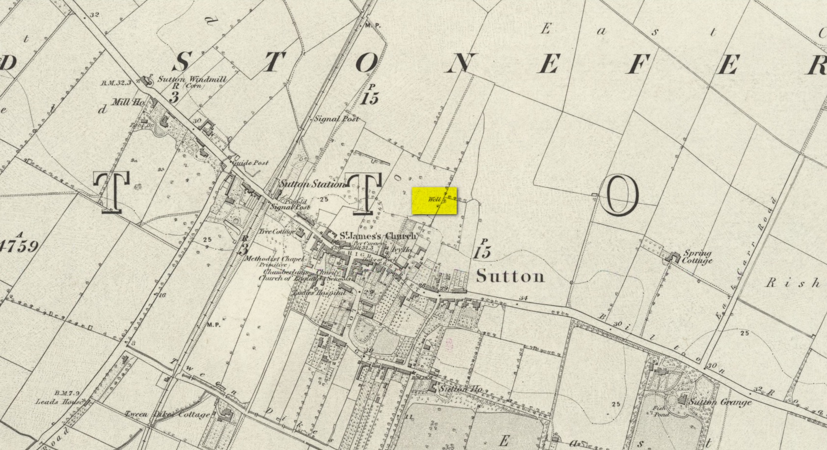
Holy Well (destroyed):  OS Grid Reference – TA 23584 25549

Archaeology & History

The Well shown on the 1855 6″ OS map

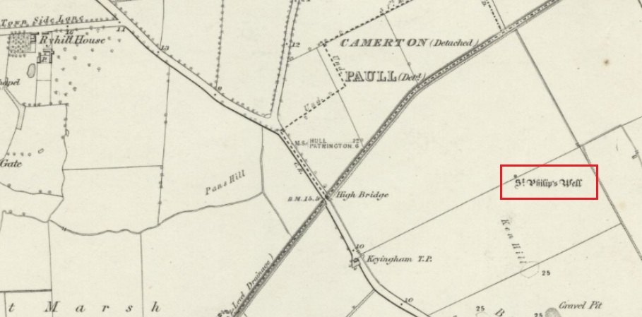
This holy well was formerly on the northern boundary of a field adjoining the north side of the A1033 west of Keyingham.

In view of the surviving folklore relating to the well it seems that its dedication to St. Philip may have been an effort by the Church to ‘Christianise’ it; and the St Philip here is not the Biblical Apostle, but a local saint – Philip Ingleberd (died c.1325 and also known as Philip Inglebred), whose memory was celebrated by a nearby Cross and a shrine at St Nicholas Church in the village.  The well and the cross may have been dedicated some time after 1392 following a ‘miracle’ relating to Philip’s tomb.  These were destroyed by the mob in the Reformation, although the cross-base survives.  It seems the well may have been restored in the late seventeenth century.  By the early twentieth century the well was described as laying on the Common to the west of the village, by then filled in, only showing signs it ever existed by making the ground near its site wet and boggy in a rainy season.

Folklore

George Poulson writing in 1841 told that,

“…a few fields more to the west is a well, called St. Philip’s Well; on a small stone are inscribed W. H. W. D. IG67. W. K.  It is called the wishing well; and the country lasses were in the habit of dropping pins, or even a sixpence into it, for the purpose of ensuring to themselves either particular or general good luck.”

William Smith (1923) described the well as one of six wishing wells or pin wells in Yorkshire and, moreover, the only ‘Cross Well’ in the East Riding.  At none of these wells was evil allowed to be foreshadowed, and the wells were only to show to a girl the portrait of her future husband.  He told us that,

“In every case the wish had to be with truthful devotion, and not divulged to any living person, or the desired consummation would not be gained…. Tradition adds that the well was much visited by maidens, who, on dropping their pins or coins, expressed the wish to see their lovers mirrored on its waters. Thus they kept a custom, dating to the time when the well was counted to be under the control of the fairies.”

And as Keyingham Common was once the abode of the fairies, it is worth noting that some 700 yards west of the site of the well a ‘Pans Hill’ is shown on the old maps, although whether this rural spirit of classical myth ever made it up to the East Riding is altogether another matter….

References:

  1. Arrowsmith, Nancy & Moorse, George, A Field Guide to the Little People, Macmillan: London 1977.
  2. Hope, Robert, Legendary Lore of the Holy Wells of England, Elliot Stock: London 1893.
  3. Poulson, George, History and Antiquities of the Seigniory of Holderness, Thomas Topping: Hull 1841.
  4. Smith, Rev. William, Ancient Springs & Streams of the East Riding of Yorkshire, A.Brown: Hull 1923.

© Paul T Hornby 2021

St. Hilda’s Well, Whitby, North Yorkshire

Holy Well (destroyed):  OS Grid Reference – NZ 9006 1102

Archaeology & History

Virgin’s Pump, c.1890

This is one of at least five wells dedicated to St. Hilda in North Yorkshire that my old colleague Graeme Chappell has uncovered over his many years of research.  It’s sadly been destroyed, and accounts of it seem to be few and far between; but from the short description of it by Mr J.C. Atkinson (1894)—and helped out by its later title—we at least know where it once was.

In his account of the old roads in the village, Grape Lane was mentioned as far back as 1396, and close by, he wrote,

“is a spring called Seynt-Hild-keld, possibly where the so-called “Virgin pump” stands, or stood, not so very long since.”

This ‘ere “virgin pump” is shown in an old photo taken about 1890, just round the corner from Grape Lane where, today, is the car park on Church Street, opposite The Endeavour.

Folklore

St Hilda was a 7th century saint who was reputed to have founded Whitby Abbey.  Her festival date was November 17.

References:

  1. Atkinson, J.C., Memorials of Old Whitby, MacMillan: London 1894.

© Paul BennettThe Northern Antiquarian

St. Leonard’s Well, Dunfermline, Fife

Holy Well (destroyed):  OS Grid Reference – NT 0976 8666

Archaeology & History

Site shown on 1856 map

There seems to be very little information available about this holy well, lost long ago and now hidden beneath the foundations of a food superstore!  It was found in close association with both a chapel and a hospital in St. Leonard’s name—both of which have also been destroyed.  The water from here may have been used by the monks for patients in the hospital, but that’s purely speculative.  St. Leonard was known to be connected with lepers, which may be something that the waters here were used to treat.  But again, I’m speculating…

When the Ordnance Survey lads came here in 1853, the waters were still running and they subsequently added it to their map a few years later.  The site was still visible when Erskine Beveridge (1917) came here, telling us briefly that,

“St. Leonard’s Well still remains a little to the south-east, and, though now built up, is recognisable.”

But a few years later it had been destroyed and its position was shown on the updated OS-map of 1926 as “Site of.”  The old well had gone…

References:

  1. Beveridge, Erskine, The Burgh Records of Dunfermline, William Brown: Edinburgh 1917.
  2. Simpkins, John Ewart, Examples of Printed Folk-lore Concerning Fife, with some Notes on Clackmannan and Kinross-shires, Sidgwick & Jackson: London 1914.
  3. Walker, J. Russel, “‘Holy Wells’ in Scotland,” in Proceedings of the Society of Antiquaries of Scotland, vol.17 (New Series, volume 5), 1883.

Acknowledgements:  Big thanks for use of the 1st edition OS-map in this site profile, Reproduced with the kind permission of the National Library of Scotland

© Paul BennettThe Northern Antiquarian

Wallace’s Well, Dunfermline, Fife

Healing Well:  OS Grid Reference – NT 08782 87275

Also Known as:

  1. Spa Well
  2. Wallace Spa

Archaeology & History

The ruins of this little-known site, dedicated to the legendary Sir William Wallace, can still be seen in the form of an overgrown stone ruin just off the footpath that runs through the Pittencrieff Glen out of the town centre.  In earlier times the waters were evidently of some repute, as a Council meeting in May 1773 reported with some disdain the closure of the waters by a Mr Chalmers:

“This Day the Council considering that the entry from the Town to the Well of Spaw is now shut up by Mr. Chalmers, which was a particular privilege to ye Inhabitants of the Burgh, Do hereby appoint the Provost to intimate to Mr. Chalmers that the Town will not give up that privilege, and to require him to oppen an entry thereto as formerly.”

We don’t know whether the miserable Mr Chalmers gave access to the well, as there seem to be no Council meeting notes telling us the outcome.  My guess would be that the local people got their way, hopefully at Chalmers expense!  More than 70 years later, another Mr Chalmers (1844) wrote about the well in a more respectful light:

“On the north edge of the rivulet, a little below this bridge, at the foot of the Tower Hill, there is a famous well, named the Wallace Spa, or well of Spa, which was formerly much resorted to by the inhabitants of the town for its excellent water, but which has been long since disused. It is noticed here simply on account of the traditionary antiquity of its name, Sir William Wallace, it is said, having once, in the haste of a flight, drank a little of it, out of the palm of his hand.”

In spite of there being local folklore of William Wallace, the local historian Ebeneezer Henderson (1879), in his giant work on Dunfermline, thought there was a more prosaic origin to the well’s name. He told,

“This well is still in existence, about fifty yards south of the ruins of Malcolm Canmore’s Tower — Tower Hill.  The water is reported as being “very cold at all times.” The water should be analysed.  The well during the period of its being used was known as the “Spaw Well,” and the ” Well of Spaw,” and, by and by an easy, natural transition, ” Wallace Spa;” and thus the name of the well has sometime been connected with that of the great Scottish hero.”

The Well after 1900
pre-1900 image

By the end of the 19th century, the well had become almost buried by earth and foliage, but was subsequently brought back to life following architectural improvements of the glen around the turn of the 20th century.  In Patrick Geddes’ (1904) work he gives us “before and after” portraits (attached here) showing how it had been restored.  He also mentioned “its tradition of medicinal value”, but could give no further information regardings the ailments it was reputed to cure…

References:

  1. Chalmers, Peter, Historical and Statistical Account of Dunfermline, William Blackwood: Edinburgh 1844.
  2. Geddes, Patrick, City Development: A Study of Parks, Gardens and Culture-Institutes, St George Press: Birmingham 1904.
  3. Henderson, Ebenezer, The Annals of Dunfermline, John Tweed: Glasgow 1879.

© Paul BennettThe Northern Antiquarian

St. Brendan’s Well, Abernethy, Perthshire

Holy Well (lost):  OS Grid Reference – NO 191 161

Also Known as:

  1. Brendan’s Well
  2. Brendi’s Well

Archaeology & History

In 1897, when Butler wrote his history of the village, he told that a certain well, “adjacent to the Gattaway stream” (thought to be the Nethy Burn which passes Gattaway farm) was known to old locals as Brendan’s Well, with the name still surviving as ‘Bredni Well’.  There were a number of large boulders around it that had been scattered by blasting, but which Butler thought were, “in all probability placed originally near the wall as a guide for pilgrims.”

The site was included in Ruth & Frank Morris’ (1982) survey, adding simply that the site was named “after the saint who lived here in the seventh century.”  In the christian calendar, St. Brendan’s day was May 16.

When the local antiquarian Paul Hornby looked for the well, a local lady told him that she thought an occasional but regular boggy patch that appeared in her garden was due to the underground waters from St Brendan’s Well.

References:

  1. Butler, D., The Ancient Church and Parish of Abernethy, Edinburgh 1897. Page(s): 102
  2. Morris, Ruth & Frank, Scottish Healing Wells, Alethea: Sandy 1982.

© Paul BennettThe Northern Antiquarian

Lambeth Wells, Lambeth, London, Surrey

Healing Wells (destroyed):  OS Grid Reference – TQ 3094 7889

Also Known as:

  1. Lambeth Spa
  2. Near Well and Far Well

Archaeology & History

This once famous healing or spa well has long gone.  It was located where the buildings that now constitute 104-105 Lambeth Walk presently stand: an area which the great London historian William Thornbury (1878) told was already “a favourite resort of Londoners, and celebrated for the variety of sweet-smelling flowers and medicinal herbs growing there,” complementing the healing waters before and during the spa craze.  The great herbalist John Gerard did his collections here.

I can find no information regarding its early use by our peasant ancestors, so its written history simply begins when it had been appropriated by those well-to-do up-market types who took this medicinal spring for their commercial gain in the early days of the trendy spas.  Supplied by two separate springs known as the Nearer and Farther Wells respectively, the Well House built here was “formally opened in April 1696” and subsequently had almost daily accompaniments of music, including French and country dancing!  But as the popularity of the Lambeth Spa increased, so did its problems.  Phyllis Hembry (1990) told that by July 1715, one visitor to the spa,

“was so depressed to find that the many people there were mostly rakes, whores and drunkards, idlers such as Guard officers, or young pleasure-seeker like attorneys’ clerks, mingling with loose women of the the meanest sort.  The Lambeth Wells also became a public nuisance, so a dancing license was refused in 1755.”

The so-called Great Room which had been the place of great occasions by spa users ended up being the meeting place “for Methodist meetings.” Oh how the winter nights must have flown by…..

There was a decided improvement in the years that followed and social events at the spa increased again.  It became what Thornbury said “was another place of amusement.”  The Lambeth Wells, he wrote,

“were held for a time in high repute, on account of their mineral waters, which were advertised as to be sold, according to John Timbs, at “a penny a quart, the same price paid by St. Thomas’s Hospital.” About 1750, we learn from the same authority, there was a musical society held here, and lectures, with experiments in natural philosophy, were delivered by Dr. Erasmus King and others. Malcolm tells us that the Wells opened for the season regularly on Easter Monday, being closed during the winter. They had “public days” on Mondays, Thursdays, and Saturdays, with “music from seven in the morning till sunset; on other days till two!” The price of admission was threepence. The water was sold at a penny a quart to the “quality” and to those who could pay for it; being given gratis to the poor.  We incidentally learn that there were grand gala and dancing days here in 1747 and 1752, when “a penny wedding, in the Scotch manner, was celebrated for the benefit of a young couple.”

By this time, a rival St. George’s Spa of had been created a short distance away on the parish boundary and with it, the popularity and attendance at Lambeth Wells began to decline.  By the end of the 18th century, the rot had truly set in and its days were finally numbered.

As for the medicinal properties of these wells, little seems to have been recorded.  Aside from repeating the common description of them being mineral waters, William Addison (1951) simply added that they were also purgative.

References:

  1. Addison, William, English Spas, Batsford: London 1951.
  2. Allen, Thomas, The History and Antiquities of the Parish of Lambeth, J. Allen: London 1827.
  3. Allen, Thomas, A History of the County of Surrey – volume 1, Isaac Taylor: London 1831.
  4. Foord, Alfred Stanley, Springs, Streams and Spas of London: History and Association, T. Fisher Unwin: London 1910.
  5. Hembry, Phyllis, The English Spa 1560-1815, Athlone Press: London 1990.
  6. Nichols, John, The History and Antiquities of the Parish of Lambeth, J. Nichols: London 1786.
  7. Rattue, James, The Holy Wells of Surrey, Umbra: Weybridge 2008.
  8. Sunderland, Septimus, Old London Spas, Baths and Wells, John Bale: London 1915.
  9. Thornbury, William, History of Old and New London – volume 6, Cassell: London 1878.

Links:

  1. Lambeth Wells on the Vauxhall History website

© Paul BennettThe Northern Antiquarian

Blind Well, Sutton-in-Holderness, East Yorkshire

Healing Well:  OS Grid Reference – TA 1204 3306

Archaeology & History

Site of well on 1855 map

We don’t know for certain the precise whereabouts of this long lost healing well, but it would seem to be the one highlighted here (right) on the 1855 OS-map.  However, I think it equally possible that the small unnamed building, roughly halfway between the highlighted ‘Well’ and Spring Cottage, where the walling meets, could be the site in question.  It’s one or the other!

Folklore

When Thomas Blashill (1896) wrote of the Blind Well in his standard history work of the area, memory of it was already falling away.  In discussing where local people could wash and look after their health, he told that

“There was one place in the parish where washing seems to have been practised as a curative measure.  Down in the East Field, near to Spring Cottage Farm, was the Blindwell, to which the people had access. If they used its waters freely when suffering from sore eyes, their faith would probably be rewarded.”

References:

  1. Blashill, Thomas, Sutton-in-Holderness, William Andrews: Hull 1896.

© Paul BennettThe Northern Antiquarian

St Everilda’s Well, Everingham, East Yorkshire

Holy Well (destroyed):  OS Grid Reference – SE 80528 42531

Also Known as:

  1. St Everildis Well

Archaeology & History

Shown on the 1855 Ordnance Survey map as a ‘pump’, in the grounds of Everingham Priory, the ‘seat’ of the lord of the manor, it was in an enclosure formerly open to the people of the village. It was filled in prior to 1923. The water was described as ‘abundant and excellent.’ Graeme Chapman, in his Yorkshire Holy Wells website states:

‘A few metres to the south of the site of the well the modern OS map marks the start of a stream (SE 8055 4250) which could be the original source of the Holy well’s water.’ 

The well shown on the 1855 6″ OS Map.

The present writer has not been able to verify this from the materials available to him.

Everilda, also known as Everild and Averil, is recorded in the York Breviary, printed in 1493. She was a mid Yorkshire Saint who died around 700 CE.  According to this source she was of a noble Wessex family who went to Yorkshire with companions Bega and Wulfreda, settling on land called Bishop’s Farm, an estate of the Bishop of York, St Wilfrid , which he gave to them, the place being then called Everildisham. There they established a nunnery, of which all trace is now lost. Her Saint’s day is July 9th. The name of St Everilda has been changed to ‘Emeldis’ in the dedication of the church at Everingham. Some historians claim the village is not named after her, but as a derivation of ‘ham of Eofor’s people’. The only other church known to be dedicated to her is at Nether Poppleton, some 17 miles north west of Everingham.

Folklore

The water of the village and the mothers of Everingham are said to have been blessed by St Everilda, and the Reverend Smith wrote that over a fifty year period, no mother had died in childbirth.

References:

  1. Farmer, David, The Oxford Dictionary of Saints, Oxford University Press, Oxford, 1987
  2. Raine, James, The Dedications of the Yorkshire Churches, The Yorkshire Archaeological and Topographical Journal, Vol II, 1873
  3. Salisbury, Matthew Cheung, The Use of York: Characteristics of the Medieval Liturgical Office in York, Borthwick Institute, York, 2008
  4. Smith, Rev William, Ancient Springs & Streams of the East Riding of Yorkshire, A.Brown & Sons, London, Hull & York, 1923
  5. Stanton, Richard, A Menology of England & Wales.., Burns and Oates, London, 1887

Link:

  1. St Everilda’s Well on Yorkshire’s Holy Wells

© Paul T Hornby 2021

Parsonage Well, Manchester, Lancashire

Holy Well (destroyed):  OS Grid Reference – SJ 836 985

Archaeology & History

Long since lost beneath the metal and concrete of modern times, even references to this forgotten place are very faint indeed.  I expected to find something of it in Henry Taylor’s (1906) giganteum, but it even slipped through his considerable work; and, even where mention of it exists, it is only in passing.  In William Proctor’s (1874) survey of early Manchester, he found deeds relating to the land and its early owners wherein the one and only mention of this well appears.  It was located near the middle of the city centre, between the Law Courts and Manchester cathedral, in the area known today as the Parsonage Gardens on the east-side of the River Irwell.  In earlier centuries this was the abode of a Christian minister, or parson, and the water from this well supplied his religious abode.  Proctor wrote:

“Crossing over to the Parsonage, we find that, in 1780, one of its residents was Mr John Quincey, linen-draper, uncle to the English Opium-Eater.  In the previous year Mr Quincey was married to Miss Martha Goodyear, of Ardwick.  His residence was bounded, it seems, on the north and west by “a narrow street or passage called Black Fryars”; while on the other points of the vane his prospect is thus shown by an extract from a lease dated 1758: — “The orchard or garden plot adjoining the river; it is now fenced out with hedges and ditches.”  Some years earlier mention is made of a summer-house, fruit trees, and plants in abundance, with “free liberty of way to the spring or well called the Parsonage Well.”  In 1686, Thomas Heyrick of Manchester, gentleman, leased a “tenement and parcel of land abutting upon a messuage and garden heretofore in the possession of George Tipping, deceased, and now the dwelling-house of the warden [Richard Wroe] of the said College; bounded on the east part with the old Parsonage ditch adjoining to the tenement of Mr John Oldfield.  Close by are or were the residences of John Nield, Hugh Boardman, Richard Haworth, Esq., and lately Jane Haworth, his widow.”  A worn parchment proves the existence, in 1698, of “Parsonage Croft;” another of “Parsonage Pool;” and an order of the Court Leet, 1594, required the tenants to “go along the hedge-side, keeping the footway towards the Parsonage style, for their fetching of water from the river.”  In 1765, an advertisement in the Mercury mentions “the sign of the Grey Horse in or near Parsonage Brow.” St Mary’s Church covers the ground once known as the Parsonage Green.”

References:

  1. Proctor, Richard W., Memorials of Manchester Streets, T. Sutcliffe: Manchester 1874.
  2. Taylor, Henry, The Ancient Crosses and Holy Wells of Lancashire, Sherratt & Hughes: Manchester 1906.

© Paul BennettThe Northern Antiquarian

Holy Well, Halifax, West Yorkshire

Holy Well (destroyed):  OS Grid-Reference – SE 100 254

Archaeology & History

This sacred site seems to have been destroyed sometime at the end of the 19th century.  It was located on the great slopes heading up to Beacon Hill.  In 1787, a property survey showed six houses here called Holy Well Cottages and on the 1852 OS-map a “Well” is highlighted at the bend in the pathway of the Old Bank as you’re going uphill, which is the place in question.  On my last visit here about thirty years ago, its position was preserved under a large manhole. 

References:

  1. Heginbottom, J.A., “Early Christian Sites in Calderdale”, in Proceedings Halifax Antiquarian Society 1988.

© Paul BennettThe Northern Antiquarian