From the village of Chipping, go along Talbot Street until it meets Green Lane and there, on the left, there runs a country lane roughly northwards. Go along this and after about 1½ mile, watch out for the track of Quiet Lane on your left. Go all the way up this track for nearly 1½ mile, till you reach its end. Diagonally across to your right, note the stile into the field. Go over this and, some 50 yards across the field, look to your south where the field rises to its small peak. This is the site.
Archaeology & History
Fair Oak enclosure
Although little can be seen of this site at ground level, aerial photography in the 1980s identified a large circular earthwork at Fair Oak Farm. The circle has a surrounding ditch and bank enclosing a raised circular mound of approximately 100m in diameter. It is thought that the feature may represent Bronze/Iron Age settlement in the area, and may possibly be a village site. The site requires further survey.
Aerial photography has identified a number of possible settlement sites in the area between Dinkling Green and the River Hodder at Whitewell and in the area around Whitmore below Totridge Fell. The largest being that at Fair Oak.
Folklore
Jessica Lofthouse (1946) told of a number of places close by that were said by local people to be inhabited by faerie folk — Fair Oak itself being no exception. Hinting of earlier heathen gatherings, she wrote:
“As for the farm of Fair Oak, where we take the path to Dinkling Green, nearby was the fairy oak, the scene of so much midsummer revelry.”
In Grassington, go up the main street and keep going uphill, out of town. You’re on Moor Road now and it keeps going northeast for about a mile, where the small copse of trees grows just before Yarnbury House. However, on the other side of the road (right) two field before you reach the house, you’ll notice a slightly raised elevation in the field, close to the wall. A footpath runs right past it, so you shouldn’t have too much trouble finding it!
Archaeology & History
This is a fine, roughly circular neolithic monument, sat not-quite-on-the-heights, but still possessing damn good views all round (except immediately west), begging the question, ‘what on earth are you and why were you built here?’ Answers to which, we don’t really know. But ascertaining its geomantic nature wouldn’t be too difficult for local people who have spent years visiting the site. John Dixon (1990) mentioned how, in the winter months,
“the sun falls behind Pendle (Hill) providing it with a sky-red backdrop. In my own view the site is related to the presence of Pendle…and may have been the major factor in the location of the monument.”
He may be right! It has been suggested by one archaeologist (King et al, 1995) that the site was “most probably a wood henge” with upright rings of wooden posts that were built onto the central platform — but until we get a full dig here, we’re not gonna know.
N-NE section of hengeSW section of the henge
Found close to an extensive amount of other prehistoric remains in the area (dating from the neolithic to Iron Age), this henge monument is notable for its size, as it’s only a little fella! It’s like a mini-version of the Castle Dykes henge near Aysgarth, 14 miles to the north! First mentioned as a ‘disc barrow’ in 1929, J. Barrett (1963) added the Yarnbury Henge to the archaeological registers 32 years later, citing it as a “circular platform 60-63 ft diameter, surrounded by a ditch 20ft wide (crest to crest) and an outer bank.” A couple of years later D.P. Dymond (1965) described the henge in slightly more detail, telling:
“At Yarnbury, just over one mile north-east of Grassington there is an earthwork 116ft in diameter overall, consisting of a ditch with external bank. On surface inspection the earthwork appeared to have the characteristics of a henge monument. An excavation carried out in July 1964 , by an archaeological summer school based on Grantley Hall, proved this thesis. There was no trace of an internal mound and the entrance to the southeast was obviously original. No traces were found of any sort of internal structure, and a square pit in the centre of the circle had been caused by an excavation earlier this century. The ditch was rock-cut and the bank of simple dump construction. No dating evidence was found… With its single entrance the Yarnbury henge falls into Atkinson’s Class 1.”
SW area of the henge
In recent years it seems that some damage has been done by digging into the east and southeastern sections of the henge. Summat we hope doesn’t get any worse. In the field on the other side of the road we found traces of prehistoric enclosure walling (along with a curious, large, almost cursiform shadow, 44 yards across and running 110 yards NE), typical of the extensive settlement remains found less than a mile away at Lea Green and High Close Pasture, Grassington. It’s an impressive area, well worth checking out!
References:
Barrett, J., “Grassington, W.R.,” in Yorkshire Archaeological Journal, part 161, 1963.
Dixon, John & Phillip, Journeys through Brigantia – volume 2: Walks in Ribblesdale, Malhamdale and Central Wharfedale, Aussteiger Publishing: Barnoldswick 1990.
Dymond, D.P., “Grassington, W.R.,” in Yorkshire Archaeological Journal, part 163, 1965.
Harding, A.F., Henge Monuments and Related Sites of Great Britain, BAR 175: Oxford 1987.
Harding, Jan, The Henge Monuments of the British Isles, Tempus: Stroud 2003.
King, Alan, et al, Early Grassington, Yorkshire Archaeological Society 1995.
Wainwright, G.J., “A Review of Henge Monuments in the Light of Recent Research,” Proceedings of the Prehistoric Society, volume 35, 1969.
Either reach this from Dorchester’s Dyke Hills by crossing the bridge over the Thames at its southwestern side and walk thru the village and up the fields to the wooded rise on your left; or simply get take the road between Brightwell-cum-Sotwell to the delightful village of Little Wittenham and, on your right-hand side, notes the unmissable clump of trees and rise in the fields on your right. That’s the place!
Archaeology & History
Major Allen’s 1932 photo
To be found on the southern side of the River Thames, across from the huge Dyke Hills camp, this prominent enclosed hillfort was thought to be a place where the tribal peoples of differing groups converged — the Dubonni, the Catuvellauni, and Atrebates peoples. And to this day it remains impressive. Long thought to have been merely the province of Iron Age settlers, in more recent years it has shown to have had a longer and richer history than academics previously dare write about. In Jean Cook’s (1985) fine work on the archaeology of the region, she described the typical narrative Castle Hill elicited from professionals until only a few years back, saying:
“The hillfort on Wittenham Clumps covers approximately 4 hectares (c. 10 acres) and comprises a single ditch and rampart. It commands superb views northwards up the Thames valley and to the south and west across the Vale of White Horse to the Berkshire Downs, where a series of similar hillforts follows the line of an ancient route — the Ridgeway. The fort has never been excavated, although frequent past ploughings have produced Iron Age and early Saxon sherds as well as Romano-British pottery. However, to the south of the hillfort…a well-stratified Iron Age settlement was found. It seems probable on the basis of other excavated sites that the fort was permanently occupied. It would have developed as a regional administrative and political centre, with specialist craftsmen and traders and would have performed some of the same functions as a medieval market town.”
Although Cook’s latter remarks should be addressed with caution (market economics was far from the mythic perspectives of Iron Age people), this great site was of obvious importance. But later excavations at the site in 2002-03 showed that the site had in fact been used by neolithic people and, around the tops, flints and other remains were found that took human activity here back into mesolithic times, with some finds dated around 6000 BC! More surprisingly (to archaeologists anyway) was that Castle Hill continued to be used way into medieval times!
Thankfully much of this place is still pretty well-preserved and is well worth exploring to historians, pagans and walkers.
References:
Cook, Jean, “Before the Roman Conquest,” in Dorchester through the Ages, Oxford University 1985.
Cook, Jean & Rowley, Trevor (eds.), Dorchester through the Ages, Oxford University 1985.
Easy to find. From Dorchester town centre, take the road at the bottom of town where the church is and walk along to the end where a footpath takes you into the field. Once here you’ll note a rise in the land at the end, stretching away to the west and the River Thames. That’s your Dyke Hills!
Archaeology & History
Plan of Dyke Hills (after Cook, 1985)
This site is another example of the considerable neglect shown to the prehistoric archaeological remains in and around the Dorchester region, despite Jean Cook (1985) describing the place as “a site of major local, regional and national importance.” Which is a pity, as the site here was once huge and it seems that much could have been learned from here. (you’ve gotta ask: do those doods who allegedly work for English Heritage care more for the ancient sites, or the money their organization gets?)
Lane-Fox’s 1870 survey
It would seem that the majority of the site was Iron Age in nature, with snifflings of Bronze Age remains scattered here and there. The primary position of the massive dykes and construction of internal domestic structures immediately below (south) of the dykes, was hemmed in on all sides by the surrounding River Thames and one of its tributaries, giving the place an excellent position in terms of food, plus shelter and protection from any intrusive tribes or hungry winter animals.
The first excavation at the huge dykes that define the northern edge of this ‘monument’ was done in 1870 by the renowned General Pitt-Rivers, then later Colonel Lane-Fox (at the time the Secretary of London’s Ethnological Society), as they were very concerned about the damage that was being inflicted upon the site, when the local landowner allowed sections of the banking to be “reduced for cultivation.” An article in the Saturday Review magazine on July 2, 1870, told of these concerns and what was written — as Jean Cook so rightly tells — “has a depressingly modern ring to it”:
“…the fortress at Dorchester and the fortress on Sinodun (Castle Hill) are among the most speaking monuments of the earliest history of our island, and till lately they were among its most perfect monuments. But it is a grievous truth that while we are writing, the dykes at Dorchester are being levelled. Hitherto the neighbourhood ground has been grazed and the harmless sheep is no foe to history; but it has lately occurred to the owner of the ground hat a few shillings more of yearly profit might be gained by turning pasture land into arable; and to such a sordid motive as this these precious antiquities are at this very moment being sacrificed. At least a third of the dyke has already been lowered, and will gradually be utterly destroyed beneath the yearly passage of ruin’s merciless plough share. Such wanton destruction naturally aroused the indignation of men of taste and knowledge, especially in the neighbouring University. A vigourous appeal to the owner to stay his hand was made by some of the most eminent Oxford residents, and an attempt was made to call public attention to the subject by describing the state of the case in various newspapers…”
Lane-Fox’s 1872 photo
But the digging into the dykes continued. For some time at least — until Colonel Lane-Fox himself went to the see the landowner and “persuaded” him to stop what he was doing. A method we should always keep in mind ourselves…
The modern state of the Dyke Hills is summarised once again in Jean Cook’s (1985) fine survey of the region, where she wrote:
“This great enclosure, known to archaeologists as an oppidum, covered 46 hectares (c. 114 acres) and as defended by a massive double bank and ditch to the north and to the east. The southern and western boundaries have all but disappeared, but can be traced in lines of modern field boundaries beyond which the Thames forms a natural boundary. The interior is (now) empty, but cropmarks reveal that it is full of enclosures, pits and circular houses aligned along a regular pattern of internal roads. Although there has been no scientific excavation within Dyke Hills, ploughing of the site has produced one of the densest concentrations of Iron Age coins in Britain.”
It would appear that this site was of considerable importance for local tribes and would have been home to powerful chiefs and impressive-looking shamans! The large Castle Hill site immediately across the river would have had obvious links to this once-omportant prehistoric settlement.
References:
Cook, Jean, “Before the Roman Conquest,” in Dorchester through the Ages, Oxford University 1985.
Cook, Jean & Rowley, Trevor (eds.), Dorchester through the Ages, Oxford University 1985.
Williams, Geoffrey, The Iron Age Hillforts of England, Horace Books 1993.
Very little can be seen of this once large oval-shaped prehistoric enclosure, a mile south of Slaidburn, on the level below the rise towards Easington Fell. Few archaeologists know about the site and there has been little written about it. Although very little of it is visible at ground level today, three-quarters of the site is vaguely discernible from the air and on GoogleEarth, as the photo here shows. The Skelshaw Ring was described in Greenwood & Bolton’s Bolland Forest (1955), where they said, “The late Colonel Parker (Browsholme Hall) claimed to have found a good specimen of an ancient earthwork above Easington Green. Unfortunately, this has been ploughed over during the last war (WWII).” And little else appears to have been said of the place until the Lancastrian writer John Dixon (2003) wrote about it. More recently John said the following about the site:
Skelshaw Ring plan (after Dixon 2003)
“This oval earthwork, 320 ft. diameter, crowns a small hill on the general slope of the east bank of Easington Beck. It consists of a ditch and bank with a gateway through the bank and a causeway across the ditch on the west side. Inside the bank and ditch the ground rises gently into a rounded hill so that most of the inside of the earthwork is well above the level of the bank.
“During the spring of 1934 a preliminary excavation of the site was undertaken by the late Dr. Arthur Raistrick. Three sections were cut through the ditch and bank and the inner area was briefly explored.
“Although nothing was obtained to date the earthwork, the sections did show the ordered structure of the site and proved the presence of large floors that may well have been the site of huts.
“This site may be compared with the large ringwork at Fair Oak Farm, SD 648 458, as both have a similar size and the same features are displayed. Bleasdale Circle, SD 577 460, is a slightly smaller ringwork, but I consider all three monument (plus: Easington Fell Circle [no:2] SD 717 492 ) to have the same origins.
“These earthworks represent the first settlements of a people determined to tame, settle and cultivate the landscape. What we observe at Skelshaw is the possible farmstead of an extended family unit, part of a clan that worked the land here some 4000 years ago in what is referred to as the Bronze Technology Period.”
Go through the gorgeous old village of Waddington northwards, uphill, along the B6478 road, towards the villages of Newton and Slaidburn; or, if you like, go from Newton village uphill southwards along the B6478 road towards Waddington. Either way, when you reach the top of the moors, park up at the car-park beside the road where the view stretches for miles ahead of you. Walk on the road for 100 yards, then take the boggy footpath left, going first down and over a stream, then up to the right (northeast) towards a small cairn on the near-horizon. From the cairn-top you’ll notice a large moorland pond a hundred or so yards ahead of you. Walk towards and past its left side and onwards again for the same distance until, in front of you (before a nearly-dried stream running downhill) keep your eyes peeled in the deep grasses on where you’ll see a very large ring raised in front of you, defined in parts by scatterings of rocks along the tops and sides. You’re here!
Archaeology & History
This is an outstanding prehistoric site, all but lost in old literary records until relocated in recent years by Lancashire historian and writer, John Dixon. However, its precise nature remains a bit of a puzzle. When John took a small party of us to the site on June 16, 2011, there was a variety of ideas as to the precise nature of the place.
Southwestern arc of the Ring
Structurally similar to a number of prehistoric enclosures in the Pennine range, this very large near-circular monument consists primarily of a very large number of rocks and stones making up a thick outer wall, presently piled less than a yard high above the peat and approximately 6 feet wide on average. From north-to-south, outer wall to outer wall, it measures more than 42 yards (38.5m) across; whilst measuring 41 yards (38m) east-to-west. There are distinct entrances on its western and northern sides, and possibly another on the east. Certain sections of the inner region are now somewhat boggy in parts, perhaps indicating there was at one time an internal spring of water. A large singular stone is found on the inner eastern section, which may have been placed there deliberately. On the northwestern inner-edge of the walling is a notable long wide stone which may have stood upright.
My first impression of the site told it to bet at least Iron Age in date, though more probably Bronze Age. But without excavations, I could be talking bullshit! It is an obvious enclosure of some sort, but there are no visible internal structures on the present ground level. There are no notable internal or external ditches and banks, which may have given the site a ‘henge’ classification. More work is obviously needed here before we can say what it is for sure.
Very little has been said of this huge ring in the past. John Dixon’s research found the site briefly described in Greenwood & Bolton’s (1955) work, saying:
“On page 24 they refer to the above site thus: ‘There is also a rough stone circle on top of the fells above Easington, like the remains of an ancient fort (the ringwork)…'”
Also mentioning how Richard Rauthmell’s Antiquitates (1746) very briefly mentions the place aswell. Apart from these passing remarks, John has found little else.
On other parts of this moortop we found scattered evidences of other early human remains (walling, cairns, hut circles), much of it unrecorded. There may well be other important prehistoric remains hidden upon these hills…
From Bacup town centre, take the A681 Sharneyford road for about 1½ miles towards Todmorden. At Sharneyford village take the footpath south for about 1 mile to Parrock Farm. At the farm, take the footpath in an easterly direction to Tooter Hill. Upon reaching the hill, head around the southern periphery for about ½-mile, or climb the hill to its height of 430 feet. Here is the former site of a Neolithic or Bronze-Age settlement. From the top of the hill you get fairly spectacular views of the surrounding countryside.
Archaeology & History
Flints from Tooter Hill
The former (or lost) site of The Tooter Hill prehistoric settlement or enclosure is not marked on any map. It has unfortunately suffered from quarrying on its periphery, but this has long since ceased. There are some small mounds at the southern side of the hill along with traces of earthworks, but I don’t know whether these are part of the former quarry workings. However, a number of artefacts have been excavated from the peat at this site; these include a tanged and barbed arrowhead with serrated edges — probably from the Neolithic period 4,500BC-2,500BC as well as a Bronze-Age arrow-head 2,500BC-700BC, and also a tranchet-shaped arrow-head of unknown date. These artefacts are housed in the N.A.T museum in Bacup town centre. Other finds from Tooter hill on display are some small flint implements such as a flint scraper, flint adze and a flint borer.
References:
Yates, G.C., “Stone Implements,” Transactions of the Lancashire & Cheshire Antiquarian Society, 5, 320-331.
From Nelson town centre go northeast towards Catlow, turning left near the Shooters Arms public house, then turn right again to the Coldwell Activity Centre. Carry on towards Thursden Valley till you see the World War 2 pillbox on the right. Here turn right and after 300 yards a picnic site and carparking area is reached along the Briercliffe road. On the opposite side of the road over a wall and barbed wire is Broadbank Earth Circle, though unfortunately there is not much to see there today.
Archaeology
First excavated in 1950 by the Archaeology Department of Liverpool University and again in the 1960s, the earthworks here stand at 1,147 feet above sea-level (350m). The site comprises of an earth circle 150 feet (46m) in diameter which encloses an inner ditch 1 foot (30.5cm) deep and 10 inches (25.4cm) across. The bank was composed of boulder clay thrown out from the ditch. A hearth was found below the bank at the eastern end. Some rough flint and chert flakes were also found together with a stone axe of Langdale origin. This is four-and-half inches or 11.4cm wide. It has a curved cutting edge and a thin rounded head. Its surface is ground smooth but there is no evidence of polishing.
The earthworks at Broadbank have suffered through farming activity over many centuries and the earthen circle is now difficult to see at ground level, though the inner ditch is still visible. The low hillside or, what look like ramparts, at the northern end by the pillbox are probably not in any way connected, though this low bank may have added to the building of the bank. Archaeologists consider the site to be of Iron Age origin.
References:
Liverpool University Archeology Department, Report and pamphlet, 1950.
Powell, J.G.E., “Excavations of a Circular Enclosure at Broadbank, Briercliffe, Lancs,” in Transactions of the Historical Society of Lancashire & Cheshire, 104, 145-151.
Settlement (destroyed): OS Grid Reference – TL 811 136
Archaeology & History
Sadly this site has been built over, as happens so much down south it seems (regional archaeo’s, architects, councillors and businesses are very much in each other pockets – even those who allege ‘pagan’ allegiances to ancient sites – hence the demise of ancient sites). Which is a pity, as it sounded a decent spot! Essex county council employee, Robin Turner, forwarded a summary of the findings from the site to The Prehistoric Society following an assessment prior to its destruction at the end of the 1970s. The brief account of what was there told:
“A small area of the site contained part of an Iron Age settlement, probably of village proportions. Three hut circles, two possible hut circles and two square four-post structures were found, as well as a number of ditched enclosures. The main settlement area was enclosed by a multi-phased series of associated palisades and ditches, the earliest of which had a causeway and external protective fence, which may have served as a defended entrance. One of the four-post structures, c.3m square, lay immediately inside the gap, and may have been a gatehouse or lookout. Three main areas were enclosed outside the settlement and are thought to have represented a stock enclosure, a working area and a field. Some evidence of pottery production, weaving, thatching and metalworking was found. The presence of unusually large quantities of deer and dog remains may have had some religious significance which carried on into the Roman period.”
Turner and his team “hoped to investigate the insdie of the settlement area more thoroughly in 1980,”but I aint been able to get a copy of the report. There was also found remains of a Roman temple here, including artifacts that were thought to have been offerings to the gods or local spirits.
References:
Champion, T.C., (ed.), “Summary Excavation Reports,” in Proceedings of the Prehistoric Society, volume 46, 1980.
Turner, Robin, “Excavations of an Iron Age Settlement and Roman Religious Complex at Ivy Chimneys, Witham, Essex, 1978-83,” East Anglian Archaeology Monograph no. 88, 1999.
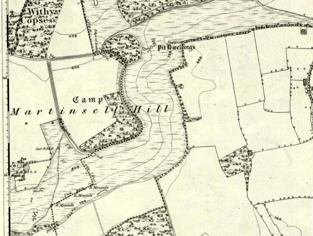
The second highest of Wiltshire’s prehistoric camps or hillforts, Martinsell Hill was described as early as the 13th century as ‘Mattelsore’ and was known in local dialect and literary forms as variants around the word mattels, until the 16th century, when the title became altered in literature and for the first time became known as ‘Martinshall’ (and variants thereof), which has stuck ever since. As the etymologists Gover, Mawer & Stenton (1939) proclaimed,
“the first element (mattels, PB) must be associated with the old english name for the camp which stands on top of it: the Mætelmesburg of the Pewsey charter” —
A.C. Smith’s old map
Which the authors think derived from “Mætelmesora, i.e., ‘Mæþelhelm’s bank'”, being the name of a tribal leader or elder who gave his name to the hill upon which the fort was built. Margaret Gelling echoes the sentiment in her Place-Names in the Landscape, but we must keep in mind that such derivation is still a quite speculative etymology and one which doesn’t seem to be able to be proven (as yet!).
The hillfort and its remains were described in some detail in the second volume of Colt Hoare’s classic Ancient Wiltshire (1819: 107), where he wrote:
“Martin’s Hill or Martinshal Hill is in North Wilts what Long Knoll near Maiden Bradley is in South Wilts, ‘collis longe spectabilis’. This elevated point commands a most advantageous prospect of the rich vale that separates the northern and southern districts of our county, , and is rendered interesting to the antiquary by an extensive earthenwork that crowns the summit of the hill. Its form resembles an oblong square on all sides, except towards the east, where it bends inward in order to humour the natural shape of the hill. Its area, which is in tillage, comprehends thirty-one acres; and as several entrances have been made through the ramparts for the convenience of agriculture, it is difficult to ascertain on which side were the original approaches to the camp. This hill, in its formation, presents a peculiarity rather contrary to the usual system of nature, by rising in height towards the east, where a bold and tremendous precipice of smooth turf shelves down from the summit to the base of the hill. This eminence is more remarkable for the rich and extensive prospect which it affords than for the plan of its entrenchments, which consists of a single vallum and fosse. Not having discovered by digging any certain marks of ancient populations within its area, I am inclined to think that it may be considered as an asylum to which the Britons, who were very numerous in its environs, sent their families and herds in times of danger: the single vallum and ditch prove its British origin, and the great extent of its area seems to warrant this conjecture.”
Hippisley Cox’s ground-plan
This aint a bad assumption for a fella who wrote this 200 years ago without the aid of excavation or modern archaeocentric analysis. But we can see that Hoare was utilizing that dying virtue of common sense here, and find that much of what he said remains the echoed narrative of modern archaeologists who, I believe, still aint done a detailed excavation on the site themselves. (weird for down South!) Later in the 19th century, when the reverend A.C. Smith (1885) visited and wrote about the hillfort, he added little to Hoare’s earlier words. And the descriptive narrative of the site remained roughly the same (Massingham’s intriguing ascriptions aside!) even after a small excavation was undertaken in 1907, which found very little. Hippisley Cox (1927) passed this way in his fine travelogue of ancient roads and trackways in Wessex, describing the enclosed top of this hill as
“the site of a complete neolithic settlement, including dew-ponds, a cattle compound, a flint quarry, lynchetts, dicthes of defence and deep cattle tracks formed by much going and coming of beasts from the valley.”
He may have been right! In more recent times Geoffrey Williams (1993) describes the Martinsell hillfort, which again only gives slightly more info than Colt Hoare’s 1819 narrative. The site covers 32 acres in size, is roughly rectangular in form, measuring roughly 330 yards (302m) across east to west, and 480 yards (439m) north to south. There appears to be at least one entrance on its northeastern edge.
Folklore
What seems to be a survival of prechristian sun lore is found in one or two of the events that used to happen upon and around Martinsell. A number of local history books give varying descriptions of the events here, but Devereux and Thomson (1979) condense the information nicely, telling us that
“The camp seems to have been a focus for curious Palm Sunday ‘games’ in past centuries, one of which involved a line of boys standing at intervals from the base to the summit of the hill. Using hockey sticks, they then proceeded to knock a ball in succession up the hill to the top. Another activity was the throwing of oranges down the hill slopes with boys going headlong after them. Evene more strangely, local youths used to slither down the escarpment on horses skulls.”
Mythographer and writer Michael Dames (1977) thought that such festive activities on and around the hill related to remnants of ancient goddess worship here.
Ley line running from Martinsell (image courtesy Paul Devereux)
In Paul Devereux & Ian Thomson’s (1979) ley hunter’s guide, the Martinsell Hill site stands at the beginning of a ley, which then runs northwest for more than seven miles, eventually ending at the well known causewayed enclosure of Windmill Hill — but not before passing by the Avebury stone circle and several prehistoric tombs on route. This ley is a simple alignment between sites (as the ‘discover’ of leys, Alfred Watkins described them) and has nothing to do with the modern contrivance of energy lines.
…to be continued…
References:
Bradley, A.G., Round about Wiltshire, Methuen: London 1948.
Dames, Michael, The Avebury Cycle, Thames & Hudson: London 1977.
Devereux, Paul & Thomson, Ian, The Ley Hunter’s Companion, Thames & Hudson: London 1979.
Gomme, Alice B., “Folklore Scraps from Several Localities,” in Folklore Journal, 20:1, 1909.
Gover, J.E.B., Mawer, A. & Stenton, F.M., The Place-Names of Wiltshire, Cambridge University Press 1939.
Harding, D.W., The Iron Age in Lowland Britain, RKP: London 1974.
Hoare, Richard Colt, The Ancient History of North Wiltshire, Lackington, Hughes, Mavor & Jones: London 1819.
Massingham, H.J., Downland Man, Jonathan Cape: London 1926.
Partidge, T.B., “Wiltshire Folklore,” in Folklore Journal, 26:2, 1915.
Smith, A.C., A Guide to the British and Roman Antiquities of the North Wiltshire Downs, Wiltshire Archaeological & Natural History Society 1885.
Williams, Geoffrey, The Iron Age Hillforts of England, Horace Books 1993.