Follow the directions to reach the Man Stone carving. Walk up the sloping hillside from there until you reach the top. From there, walk down the slope heading slightly to your left. You’ll find it!
Archaeology & History
A small upright stone, less than three feet tall, but once a little taller as you’ll see that it’s head has been knocked off in the not-too-distant future and lies on the ground by its side. A small scatter of what seems like possible cairn-material lies around its base, but not enough to imply that a tomb of any sort was ever here (aswell as that, the position on the slope seems wrong).
A curious little thing, without archaeological companions. When we came here the other day, we explored the ground all round the stone as all the heather had been burnt back; but there was nothing anywhere near it to give a hint as to why it stands here, alone, at what seems like a strange spot two-thirds the way up a moorland slope. It’s been speculated that in the middle of its more north-facing side there is a cup-mark on it, but this is very dubious and, in my opinion, should be discounted as such. The marking is a gun-shot wound – and more recent ones have just been added, as seen in the photo.
Takes a bit of finding this – but if you like your rock art, it’s worth the search! You can follow directions for the getting to the Man Stone then, when you reach it, look to the near horizon to the east. Get to the bottom of the sloping hillside where a large rounded boulder sits and walk up the slope about 10 yards. Look around here cos you’re very close.
Woman Stone carvingCarving highlighted in chalk
Alternatively, from the Askwith Moor Road, follow the path to the triangulation pillar on Shooting House Hill. Keep going for another 100 yards and check a small path to your left (south). Follow this down until you get to the top of the slope. Go to the bottom of the slope and look around!
This carving is best checked out in winter and early spring: if you go here in summer & autumn there’s bracken covering the entire site & you’ll never find it!
Archaeology & History
Drawing by Inmaculada Ibanez-Sanchez
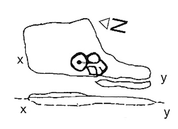
This stone was first discovered by Graeme Chappell and I during one of our many ambling explorations here in the early 1990s and was first mentioned in my Old Stones of Elmet (pp.149-152). Marija Gimbutas would have loved this seemingly matriarchal-looking cup-and-ring carving, suggestive of many Mother Goddess images she found across Europe – hence its title!
Woman Stone design (after Boughey & Vickerman)
I don’t think that the old-school archaeological types would lower themselves to say such a thing, but as I aint one of them I’m quite confident in saying that this carving does seem to be a pictorial representation of a female figure: one of the earliest of its kind in the British Isles? (check its nearby male compatriot, the Man Stone – a distinctly human figure and one of the earliest of its kind in the British Isles) Very close by we are left with old place-name remnants pointing directly at the presence of pre-christian goddess remains in the mythic landscape – an issue I’ll expand on in the near future.
In the survey by more recent rock art students Boughey & Vickerman (2003), their illustration of the carving makes it look even more like an early female figure! (though I hear they don’t like people giving the carvings names – unless, of course, one of them lot names it…)
References:
Bennett, Paul, The Old Stones of Elmet, Capall Bann: Milverton 2001.
Boughey, Keith & Vickerman, E.A., Prehistoric Rock Art of the West Riding, WYAS: Wakefield 2003.
Gimbutas, Marija, The Language of the Goddess, Harper-Collins: San Francisco 1989.
Gimbutas, Marija, The Civilization of the Goddess: The World of Old Europe, Harper-Collins: San Franciscoo 1991.
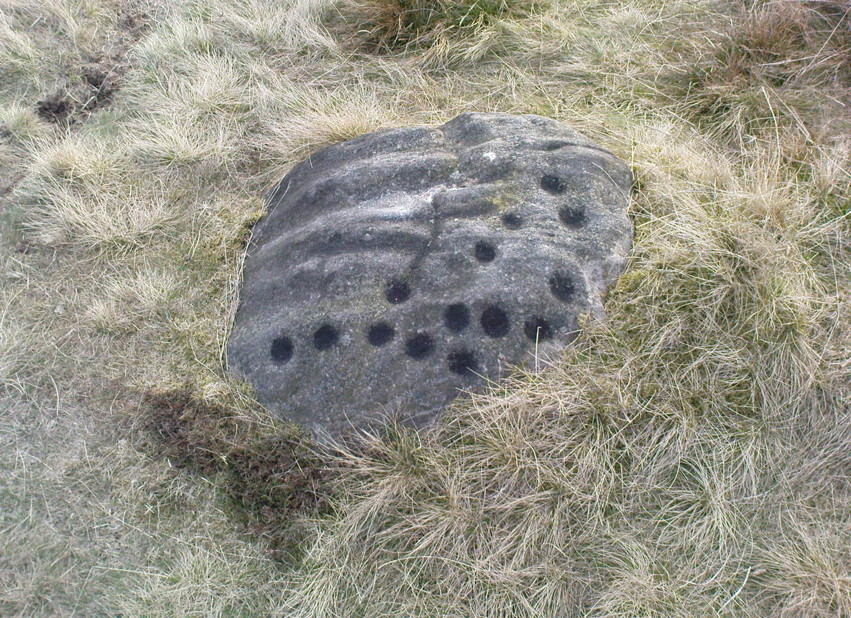
About 10 yards north of the old boundary stone on the Middle Ridge heading to the western end of Dryas Dike and about 10-15 yards east of the Middleton 453 carving, is this small rounded rock with between 12 and 15 cup-markings on its north and north-eastern sides. Several curious deep ridges run down across the rock which some ascribe as being man-made – but to me they’re Nature’s fine handiwork, although I may be wrong…
References:
Boughey, Keith & Vickerman, E.A., Prehistoric Rock Art of the West Riding, WYAS 2003.
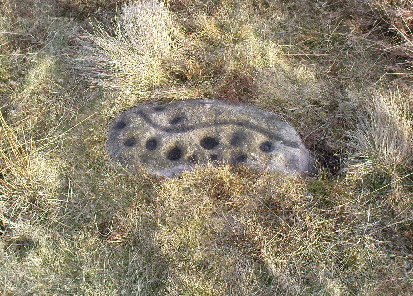
Named boringly after the catalogue number given it in Boughey & Vickerman’s (2003) survey, this is another of the many small cup-marked stones clustered at the western end of the ridge between Delves Beck and Dryas Dike, below the moorland slope up to the Old Pike and Beamsley Beacon. It’s one of the more impressive of the carvings in this locale, albeit when it’s highlighted, as in the photos shown here (apparently done by one of the photographers in the Ilkley rock art group, I was told). It’s perhaps better seen when the sun is low and the stone’s been wet, which shows the shallow undulations of the cup-marks and wavy line that seems to split the main group of twelve cup-marks at the top northern side of the stone, from the two on its south side. There seems to be another wavy line carved above the main cluster, but this is difficult to make out.
References:
Boughey, Keith & Vickerman, E.A., Prehistoric Rock Art of the West Riding, WYAS 2003.
From the old T-junction in the hamlet of Langbar (where some doods have stuck up one of those ‘Private Road’ signs, typical of those Southern-types who bring their weird private land notions up here), go along the ‘private road’, keeping to the left until the road runs out. Then follow the small footpath above the house onto the moor, following the lines of walling along, crossing boggy streams, up the small hill and, once over the top and dropping down, keep your eyes peeled for the large boulder to the left of footpath, and a small scattered cairn on your right. It just a few yards past the cairn material!
Archaeology & History
Just 20-30 yards up the slope on the north side of Dryas Dike stream, to the left of the footpath, is a small, rounded flat stone with perhaps as many as eight cup-markings on it. Six seems more believable — though some of ’em on here (if not all) don’t look to have the air of authenticity that some of the other carvings hereabouts possess. One of the cups has a small ‘tail’ protruding from it. It’s a rather cute little thing! A small, unexcavated cairn lies in ruin about 10 yards east of the crude carving.
…and from another angle
On the other side of the footpath from here is that “large boulder” I mentioned above, which is reported by Boughey & Vickerman (2003) to have “one clear cup” marking etched upon it. They also report that archaeologists from “English Heritage report two cups and a possible short groove” on this rock. However none of the carvings reported here by either authority are man-made. All marks on the rock are completely natural and it needs omitting from any future archaeological survey.
References:
Boughey, Keith & Vickerman, E.A., Prehistoric Rock Art of the West Riding, WYAS 2003.
In the middle of the moors, with no footpaths close by. Unless you’re a rock-art freak I guess there aint gonna be too many people searching for it! From the Ilkley-to-Langbar road, take the track (Parks Lane) onto the moor where the road bends right. Follow it up for about a mile (though it doesn’t seem that far) and where the cup-marked stone at the edge of the wall where the spring appears (Middleton Moor carving 483), walk west (left) into the heather for a coupla hundred yards below Foldshaw Ridge. Look around!
This is one of a small cluster of carvings Richard Stroud found on a few average-sized stones prettty close to each other in April 2005 — and one which the West Yorkshire Archaeology Service told him couldn’t be there cos the region had already been surveyed. Hmmm…
Crap drawing!
Well, my first impression of this when I saw it was a absolute thumbs-up! Simple to look at, I know – but a bloody good little carving. It’s primary characteristic is that most of the ten or eleven cups occur on the vertical and near-vertical face, which aint too common. In traditional societies (though not all) where carvings occur on vertical faces, they’re deemed to be ‘male’ in nature (those on rounded smooth surfaces, female). The carving is well worth checking out — especially as there’s probably more to be found up here, hiding beneath ages of peat and heather.
To find this, follow exactly the same directions as that of the Middleton Moor Carving 001, which is just a few yards away. Both of these stones may take some finding when the heather’s deep — but when we first discovered them, the heather had recently been burnt back.
Archaeology & History
This small rounded stone had a covering of vegetation on it when Richard Stroud and I first discovered it in April 2005, with just a couple of cups visible, but once the heather’d been carefully rolled back, another fine carving greeted our keen-eyed petroglyphic senses!
Drawing of the carving…and again!
At least eight cups seem apparent here, though once Richard had the photos processed there appeared to be a couple of things on the stone which we hadn’t noticed when in the field (a common cup&ring dilemma). One of the most curious parts of the stone seems to be the winding line near the bottom of the stone. Make of it what you will!
Just a couple of yards east of this carving we find the rounded remains of a single burial cairn, probably for just one person, just like as with Middleton Moor 001. This site could do with excavating, as we may have a small neolithic or Bronze-Age cemetery hiding under the heath.
Go up the long winding Ilkley-Langbar country moorland road. A coupla miles along there’s a sharp bend in the road, left, with a dirt-track here that takes you onto the moors. Walk up here to the shooting house just east of Black Hill in the Middleton Moor enclosure and, once there, walk up the steepish slope to the left (west). Once on the level, head to the wall and about halfway along, look around. If the heather’s long and deep you’ll be lucky to find it. Good luck!
Archaeology & History
Photo by Richard StroudSketch of the carving
The carving was first discovered by Richard Stroud and I in April, 2005, amidst one of several exploratory outings to records known sites and, aswell, to keep our eyes peeled in the hope that we might find some new ones! This was the first we came across; but when we found it, just one faint cup seemed noticeable on the southern edge of the small rounded stone; but after fifteen minutes of carefully rolling back the vegetation, this very well-preserved carving was eventually unveiled before us. It’s in quite excellent condition! The most notable part of the design are the two deep cup-markings, with the topmost cup looking half-surrounded by smaller cups on its southern edge.
There is also a well-preserved, though overgrown burial cairn (probably for one person) just a few yards west of this stone. This is just about impossible to see unless the heather’s been burnt back.
Using the OS-map as a guide, from Denton village head up the road northwest, past Moorside Farm and onto the moor. Before you reach the rise of Lippersley Pike you’ll reach the Crow Well itself (completely covered over by Yorkshire Water’s handiwork, stopping anyone from drinking the previously fresh waters here). In the middle of nowhere, just above the completely ruined well, is the old shooter’s cottage and from here, Eric Cowling (1946) told us to look in the heather immediately east. When Richard Stroud and I ventured here a few years back (2.8.5) we couldn’t find a thing — though a vaguely reminiscent structure seemed possible 300 yards away.
Archaeology & History
If the heather’s deep, you’ll have little chance of seeing the site as Eric Cowling (1946) obviously did! He described and illustrated this place — so was fortunate enough to have ventured here following the heather-burning.
The site is not a stone circle, but what Cowling thought to be an Iron Age settlement: ellipsoid in shape and nearly 400 feet across; it’s obviously an impressive archaeological site when visible (akin to the Snowden Carr settlement a couple of miles east). In all probability the site is much earlier than Iron Age.
An aerial image of the site indicates its size to be very close to Cowling’s initial measurements. The ‘settlement’ is quite huge, with the walling or defining edges being between 4 and 6 yards across in places, with double-walled sections akin to that found at the Brackenhall circle on Shipley Glen, just over 8 miles (13km) to the south. However, it’s probably much older than its Brackenhall compatriot. Its maximum diameters measure 130.5 yards (119.3m) roughly east-west and 98.5 yards (90m) roughly north-south, with an external circumference of about 345 yards (315m). This is a big fella! Near its centre is a well-defined ring, or ellipse, measuring approximately 20 yards (18.3m) north-south and 18 yards (17.5m) east-west.
It’s difficult to say what this might be without a site analysis, and we need the heather burning back at this site to enable a good inspection of the place! We may be looking at Denton Moor’s equivalent of the Woofa Bank Enclosure just over 4 miles (6.5km) to the south, above Ilkley, with its host of cup-and-rings and surrounding cairns. A good inspection of this site is long long overdue…
Hereabouts Cowling also found other remains dating from the neolithic period, including walling, cairns, hut circles and cup-and-ring stones. He thought that “the name Crow-well appears to be the modern equivalent of ‘the circle of the well'” — and although I doubted this in my Old Stones of Elmet, I have since come to realise the truth of his words!
From Askwith village, at the T-junction, go up Moor Lane, taking the left turn up Moorside Lane about half-a-mile up and on the track to Moorside Farm and then onto Top Moorside Farm. Take the path past the farm up onto the moor, then bear right up the small track that heads up onto the small Hollin Tree Hill. As you go up the track, watch out for the small grassy depression to the right; and hereby head into the grasses on your right. You’re close!
Graeme Chappell was the first to rediscover this carving in the early 1990s when we were up pottering about on these and the adjacent moors, looking for any previously undiscovered prehistoric relics. We found quite a lot! The carving here is nowt special to look at really, but the cups can be seen quite clearly. It’s a rather large stone on the western edge of the hill with at least seven or eight cup-marks carved across its upper surface. Boughey & Vickerman (2003) later described it as “large, fine quartz sandstone rock with surface sloping slightly down into (the) hillside. Seven or eight cups, two particularly sharp.” There’s a possible line running between two of the cups, visible when lighting conditions are right — though we aint sure whether it’s artificial or not.
References:
Boughey, Keith & Vickerman, E.A., Prehistoric Rock Art of the West Riding, WYAS 2003.


")


