Go northwest along the country lane running between High Utley (on the outskirts of Keighley) and Steeton known as Hollins Lane, which then becomes Hollins Bank Lane. You’ll see the fine castle building as you go along, known simply as The Tower arising from the top of the tree-line. As you get to the driveway leading down to the Tower, a less impressive farm building is on the other side of the road, known as Hollins Bank Farm. On the right-hand side of this house is an old overgrown road. Walk along here to the end, going into the field immediately left where a small group of stones can be seen halfway up the field by the tree. You’re here!
Archaeology & History
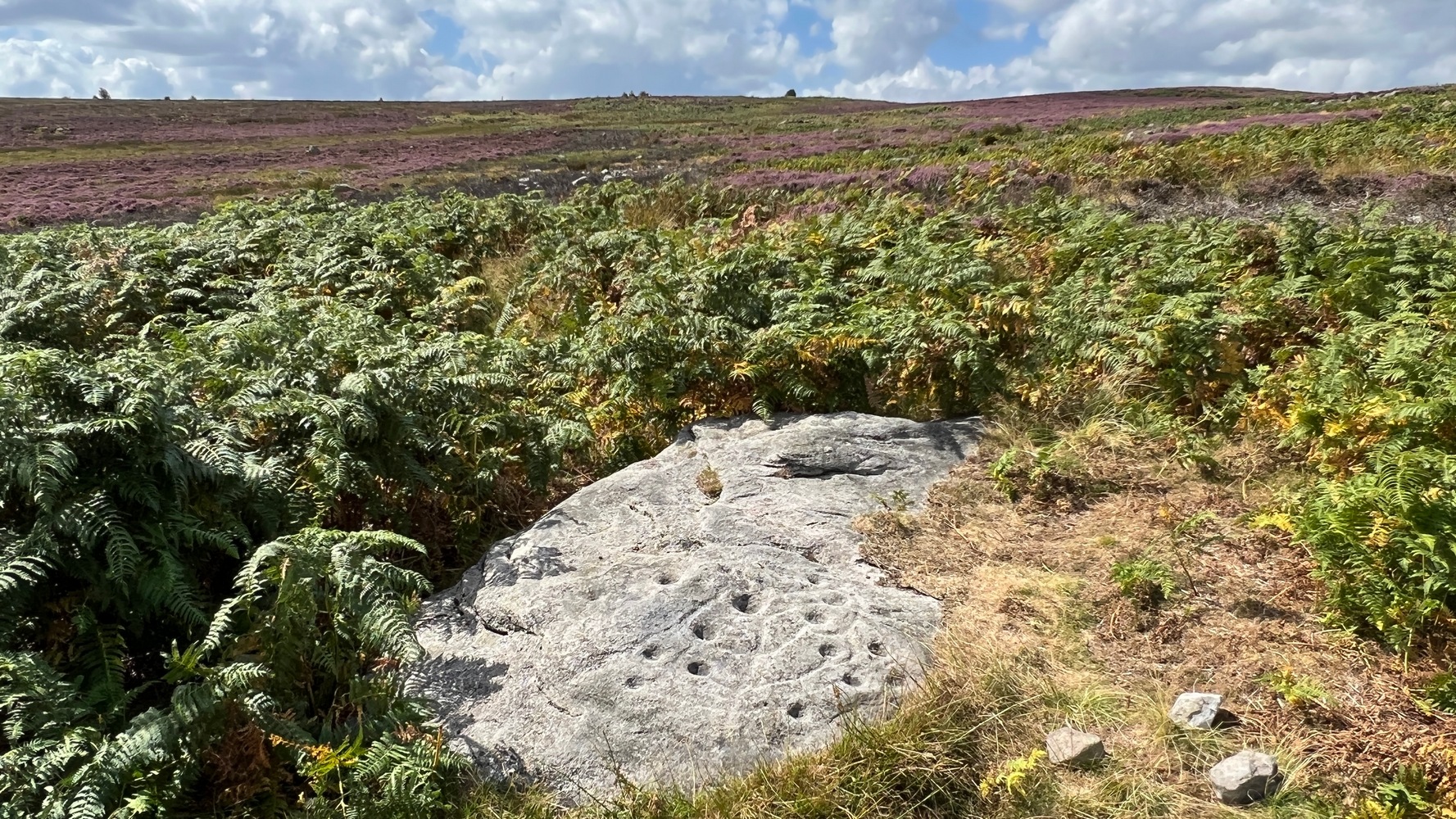
First discovered one sunny afternoon on April 7, 2010, in the company of Buddhist scholar Steve Hart, this is a really curious carving, inasmuch as it seems to have been deliberately carved around what may be curious naturally eroded cup-forms. You’ll have to visit it to see what I mean. They’re a bit odd. Almost too perfect as cups to be the ancient eroded ones we’re used to looking at. But this aside….
…and againDragon Stone, looking NW
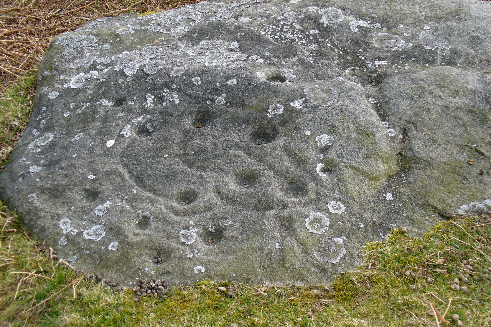
It’s a lovely flat stone, with curvaceous lines running across the middle and edges and into cup-markings. Although some of the cups give an impression of being natural, others have the authentic-looking ring to them, with at least one of them possessing a near-complete ring encircling it (as you can faintly see in the close-up photo here). There are at least 19 cup-markings on this stone, and four main ‘lines’ running roughly in north-south directions, with the cups interspersed between them. At the top (north) end of the rock, separated by a crack, the lines stop and we just have some cup-markings. The crack in the stone may have been functional here.
Although graphically different, the carving has a similar feel in design (for me at least) to that of the Wondjina Stone at Rivock Edge, on the other side of the Aire Valley a couple of miles east of here — though this newly found carving is in a better state of preservation. The small scatter of rocks around it seem to have been unearthed or moved recently by the land-owner (who aint keen on you looking on his land, so be careful) and the good state of preservation may be that they were only unearthed sometime this century. We must also keep in consideration that the lines that run across the surface of this stone are water-lines and may be more the result of Nature’s hand than humans. It’s obvious that some human intervention has occurred here, but it may be difficult to ascertain the precise degree of affectation between the two agencies.
Close-up of cups & lines
According to the archaeological record-books there are no carvings here, but another simple cup-marked stone accompanies this more extravagant serpentine design just a few yards away; a simple cup-marked stone may be seen at the top of the hill; and the faint Currer Woods carving can be found 0.68 miles (1.09km) due west of here, on the other side of the small valley. Other outcrop stones scatter the fields and slopes here, some of which still need checking to see whether or not further carvings exist.
…And for those who may bemoan my seemingly romantic title of the carving: remember! — close by in Steeton township, between the years 1562 and 1797, there was an old field-name known well to local folk, of “one parcel of arable land in town field called Drakesyke, 3 acres”, i.e., the dragon’s stream or dyke. (Gelling 1988; Smith 1956)
References:
Clough, John, History of Steeton, S. Billows: Keighley 1886.
Gelling, Margaret, Signposts to the Past, Phillimore: Chichester 1988.
Smith, A.H., English Place-Names Elements – 2 volumes, Cambridge University Press 1956.
To be found a couple of hundred yards west of Askwith Moor Road, head towards the bottom of the row of grouse-butts, following the fence that runs into the moorland across from the dusty car-park.
Archaeology & History
Single cup-marked stone
This single cup-marked stone — list as carved stone no.529 in Boughey & Vickerman’s (2003) survey — was reported when some English Heritage doods came here and found this small upright stone (probably part of a larger prehistoric monument, e.g., walling or cairn) and gave the cup-marking their “all clear” stamp and thought it authentic. But if memory serves me right (which it doesn’t always do these days!), I’m pretty sure Graeme Chappell came across this possible carving in the early 1990s during one of our many forays over these moors. It’s a cute little thing — though only for the purists amongst you perhaps — but, of course, needs to be seen in the context of its proximity to the many other prehistoric monuments across this moorland plain.
References:
Boughey, Keith & Vickerman, E.A., Prehistoric Rock Art of the West Riding, WYAS: Wakefield 2003.
Stuck in the middle of the moor, at the bottom (southern) side of the Lippersley Ridge promontory. Head towards it from the Askwith Moor Road, along the track past Sourby Farm and onto the end. Then walk along the easy footpath which that takes you below the southern side of the ridge and, about 100 yards before getting to the end of the rise, look around in the heather. You’ll find it.
Archaeology & History
Graeme Chappell’s early photo of the carving
Graeme Chappell rediscovered this seemingly isolated cup-marked stone during one of our many exploratory ambles upon these moors in the early 1990s. The carving is a pretty simple one, consisting of between 10 and 12 cupmarks on the upper surface of a reasonably large elongated stone. No discernible rings or other lines seem to be visible. There are no other cup-and-ring stones close by; but two small prehistoric cairns can be found along the same sloping ridge east and west of here when the heather is low, and the larger Lippersley Pike Cairn stands out on the western end of the ridge 450 yards away. A more detailed exploration of this part of the moor may bring other previously unknown findings to light.
References:
Boughey, Keith & Vickerman, E.A., Prehistoric Rock Art of the West Riding, WYAS: Wakefield 2003.
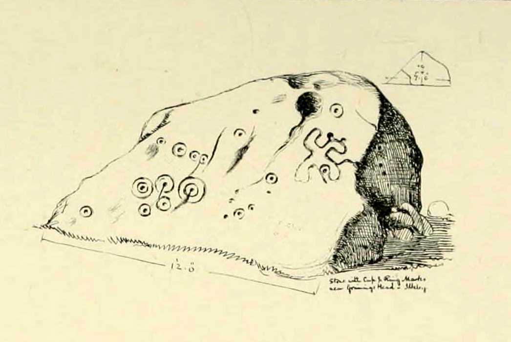
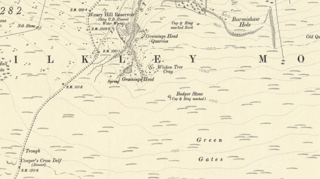
Although there are several routes to this site, for those who are not used to walking or find maps difficult to read [get a life!], it is best approached from the Ilkley side of the moor. Follow the old track that cuts the moor in half past the remains of Graining Head quarry where the moor begins to level out. Once here cut straight east until you find the footpath which, after a while, you will see leads to a wooden seat right in the middle of nowhere. Here is our Badger Stone.
Archaeology & History
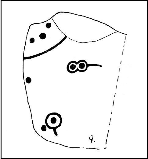
An eroded but quite excellent cup-and-ring stone — one of the very best on Ilkley Moor — comprising nearly a hundred cups, ten rings, what seems to be a half-swastika design, plus a variety of other odd motifs. It’s one of the best carvings on the entire moor and has been written about by many folk over the years. First described in an early essay on cup-and-ring stones by J. Romilly Allen (1879) — who must have visited it in poor light, as some elements of the carving weren’t noticed — he described it as a “sculptured stone near Grainings Head”, saying:
“This stone…is a block of gritstone 12ft long by 7ft 6in broad, by 4ft high. The largest face slopes at an angle of about 40° to the horizon, and on it are carved nearly fifty cups, sixteen of which are surrounded with single concentric rings. At the west end of the stone are a group, three cups with double rings and radial grooves. At the other end, near the top, is a curious pattern formed of double grooves, and somewhat resembling the “swastika” emblem… At the highest part of the stone is a rock basin 8in deep and 9in wide. On the vertical end of the stone are five cut cups, three of which have single rings. This is one of the few instances of cup and ring marks occurring on a vertical face of rock.”
Badger Stone on 1910 map
The title “badger” dates back to at least medieval times when, as the Yorkshire historian Arthur Raistrick (1962) explained, the word represented “a corn dealer, corn miller or miller’s man.” It is likely that this traditional title goes much further back, probably into prehistory, as grain was one of the earliest forms of trade. Very close to this sacred old stone are place-names verifying this, like Grainings Head and Green Gates. A little higher upon the moor is the twelfth century Cowper’s Cross (which used to have cup-markings etched upon it) where, tradition tells, a market was held that replaced an older one close by.
The Badger Stone carvingClose-up of cup-and-rings
Our Badger Stone rests beside the prehistoric track which Eric Cowling termed “Rombald’s Way” (after the legendary giant, Rombald, who lived with his old wife upon these hills): an important prehistoric route running across the mid-Pennines. This ancient route runs east-west, traditionally the time of year when agricultural needs are greatest at the equinoxes. This may have been the time when any ancient grain traders met here. (In modern times a number of archaeologists have emphasized such routes as “trade routes”: a notion that derives from the modern religion of Free Market Economics in tandem with the rise of Industrialism and social Darwinism, much more than the actuality of them as simple pathways or means of accessible movement).
There are accounts from other places in Yorkshire about these badger men. We find a number of other “badger” stones, gates, ways, stoops and crosses on our Yorkshire hills. One of them in North Yorkshire, wrote Raistrick (1962), “is an ancient trade way.” In Richmond, North Yorkshire, around the time of the autumn equinox, Badger men from across the Dales followed the old routes over the hills into town, held annual festivities and sold their grain. (see Smith 1989; Speight 1897) It is perhaps possible that our old Badger Stone would have been a site where some form of indigenous British Demeter was revered.
Sketch of Badger Stone carving
Some elements of the Badger Stone carving have what could be deemed as primitive human images (anthropomorphic) mainly on the northwestern side of the rock, emerging from the Earth Herself. And certainly amidst the same portion we have a very distinct ‘solar’ symbol, very much like the ones found at Newgrange and, for that matter, many other parts of the world.
Some New Age folk have given the fertility element to the Badger Stone a deeper status, using imagination as an aid to decode these old carvings. When feminist New-Age writer Monica Sjoo visited Badger Stone she described it as “erotic”, with the carvings giving her a distinct impression of “vulvas” and she also thought orgies of sorts had been enacted here. (Billingsley & Sjoo, 1993) The vulva imagery is a well-known idea to explain cup-and-rings and in some cases this will be valid; but when I passed an illustration of this rock-art to a number of people (all women), there was not a vulva to be mentioned — merely the OM symbol, sperm entering the egg, a snail, a bicycle, a willy, a paw-print, eyes, a face, a tadpole, cartoon breasts, the rear end of a dog, grapes, letters, numbers, ears and a snake! Awesome stuff! Take a look at the design yourself and see what you can see in it. Answers on a postcard please! (The dilemma of making specific interpretations of these carvings is that we tend to approach them with dominant ego perspectives, many of them reflecting little more than our own beliefs or search for identity, imposing unresolved journeys and conflicts on that which we encounter, as with the above case.)
As with prehistoric rock-art in general, they are a number of things: functional, ritual, history, spirit; different at each and every site. As if to exemplify this at Badger Stone, note how the detailed carvings have been executed mainly on the southern face of the stone. The northern face has little if anything to show on it. It would suggest therefore, that this stone had some mythic relationship with events during daylight hours. But we have to be careful here…
At sunrise on a good morning, we note how the eastern edges of this stone show up very clearly indeed. If Nature’s conditions are damp and wet (as they tend to be each morning on the hills), the visible outline of these cup-and-rings show up very clearly indeed. Oddly, as the sun then passes through the daytime sky each and every day on its cyclical movement, the petroglyphic content becomes a little less visible unless the stone is wet. Indeed at sun-high (midday period) the carving doesn’t show up as well as it did in the morning light. And we find the same characteristic as the sun goes to set in the west: where that part of the carved stone shows up very clearly again — much clearer than during full daytime hours. If rain has fallen, the glyphs stand out very clearly indeed.
As all cultures imbued the natural world with animistic, living qualities, it seems probable that these periods of the day (sunrise and sunset) were significant at this particular carving. It may be, very simply, that the Badger Stone “came to life” with the sunrise and its mythic nature was alive during this period; whereas with many other carvings (both on these moors and elsewhere in Britain) their strong mythic associations related to the northern Land of the Dead. But then, I could be talking bullshit!
The Badger Stone is also a strong contender for it being a painted stone. Many petroglyphs like this in other cultures were ceremonially coloured-in using lichens and other plants dyes at certain times of the day or year, relating specifically to important mythic relationships between the people and the spirit of the rock at such places. This probably occurred here.
References:
Allen, J. Romilly, “The Prehistoric Rock Sculptures of Ilkley,” in Journal of the British Archaeological Association, volume 35, 1879.
Bennett, Paul, The Old Stones of Elmet, Capall Bann: Milverton 2001.
Billingsley, John & Sjoo, Monica, “Monica Sjoo in West Yorkshire,” in Northern Earth Mysteries, no.53, 1993.
Boughey, Keith & Vickerman, E.A., Prehistoric Rock Art of the West Riding, WYAS: Leeds 2003.
Hedges, John, The Carved Rocks on Rombald’s Moor, WYMCC: Wakefield 1986.
Cowling, Eric T., Rombald’s Way, William Walker: Otley 1946.
Raistrick, Arthur, Green Tracks on the Pennines, Dalesman: Clapham 1962.
Smith, Julia, Fairs, Feasts and Frolics: Customs and Traditions in Yorkshire, Smith Settle: Otley 1989.
Speight, Harry, Romantic Richmondshire, Elliot Stock: London 1897.
Take the road from Ilkley town centre up towards the White Wells and keep following it along until it curves up and onto the moor itself and becomes a rocky dirt-track. Go up here, past the old quarries (left) until you hit the footpath which runs east (left) onto the flat level of the moorland. Follow this footpath along for literally half-a-mile, where a footpath runs up onto the tops of the moorland. Go up here for 100 yards and you’ll see a small standing stone by the right-hand side of the footpath; on the left, into the moorland about 20 yards away, this carving is to be found!
Archaeology & History
This is an excellent, archetypal cup-and-ring stone carving and is in a very good state of preservation. Found just a few yards away from the aptly-named Pitchfork Stone, the carving here on a large single stone mainly comprises of a double cup-and-ring. A couple of other possible outlying cup-marks can be seen: one just below the double-ring, and the other towards the top-end of the rock. It was first reported by Stuart Feather in the Bradford Archaeology Group’s journal in 1961, then listed in the surveys of Hedges (1986) and his followers.
Carving 257, looking NE
When Michala Potts, Dave Hazell and I we visited this carving the other day, some halfwit had been up here in the not-too-distant past and, as with some of the carvings on the moors north of Ilkley, had daubed some paint or oily resin onto the carvings themselves to specifically highlight aspects of the carved rock (not one part of the uncarved stone had anything on it). We aint quite sure exactly what the substance is that’s been daubed onto the carvings (it aint ordinary paint), but seems like an oil or industrial substance. And, whoever’s done this, obviously seems to have some knowledge of the rock art they’re painting over: they certainly have good grid-references and enjoy walking the hills. This aint just some idiot/s into vandalizing the carvings for the sake of it, nor the whim of some airy-fairy New-Ager. Whoever’s done this (and it’s been done on other cup-and-rings around this locale) have deliberately set out to locate and paint over specific carvings — a number of them off-path — with the intention it would seem to highlight them for photographic enhancement. So — whichever retard has done this, might I suggest that you keep your industrial waste where it belongs: in your own house you fucking moron! If anyone knows who is doing this to the carvings round here, please email me (anonymously if necessary) with all relevant info. Any such communications regarding this matter will be kept strictly confidential.
References:
Boughey, Keith & Vickerman, E.A., Prehistoric Rock Art of the West Riding, WYAS: Leeds 2003.
Hedges, John, The Carved Rocks on Rombald’s Moor, WYMCC: Wakefield 1986.
Walk up from Ilkley to the White Wells and keep following the footpath upwards, up the steps and onto the moor itself. Once you’ve got to the top of the steps above the rocky valley, look straight up the slope in front of you and walk directly up the hill. As you near the top, there’s a large cairn sat on the brow of the hill (known as the Coronation Cairn). This ‘ere carving is just a few yards below it.
Archaeology & History
Very little has been written of this albeit innocuous carving — if indeed it is a carving! Found on the large (though overgrown) flat stone just a few yards below the Victorian cairn, all that we appear to have here is a large cup-marking with a small arc pecked around its southern side and a distinct straight line running outwards from the cup (though the line doesn’t actually touch the cup-mark and does give the distinct impression of being pretty recent). A sort of “cup-and-half-ring” with extended line is perhaps the best description!
Close-up of cup & linesCarved Stone 270
It was first reported by some English Heritage archaeologist — which, as is generally acknowledged, isn’t necessarily a good pointer for authenticity when it comes to identifying prehistoric rock art.* But it’s certainly got a bit more about it than some “carvings” they’ve reported in the past! Boughey & Vickerman (2003) made the following notes of this stone:
“”Low, flat gritstone rock quarried away on E side, fairly smooth but uneven. One large cup and deep groove slightly curving round edge of cup.”
Which is about right. I don’t really think too many of you will be into this unless you’re a real rock-art fanatic!
References:
Boughey, Keith & Vickerman, E.A., Prehistoric Rock Art of the West Riding, WYAS: Leeds 2003.
Hedges, John, The Carved Rocks on Rombald’s Moor, WYMCC: Wakefield 1986.
* A number of cup-marked stones identified by English Heritage archaeologists have transpired to be nothing more than natural erosion.
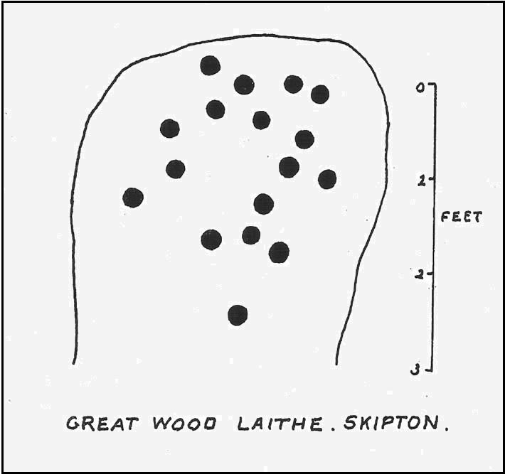
From Skipton centre get to the Horse Close estate on the southern side of the town and look up to the fields on the sloping hill above it with the small woods above ’em. Head up towards the trees, but before you get there go into the fields on your right, and in one of them you’ll see what looks like a pile of rocks near the middle. Head for it!
Alternatively, follow the directions to reach the Horse Close Hill enclosure, then walk down into the field on its western edge. You can’t really miss it!
Archaeology & History
This carving first saw the light of pen-and-paper in the early 1960s, soon after the Yorkshire antiquarian Eric T. Cowling (he of Rombald’s Way fame) was led to the site by his wandering nose and the aid of local people. He sent a letter to the editor of the Bradford archaeology group at the time (a certain Mr Sidney Jackson), which told:
“South-west of the wood which gives its name to the Great Wood Laithe at the western end of Rombalds Moor and overlooking Skipton from the east, is a cup-marked boulder: NGR – SD 99625055. In the middle of the field alongside the wood is an outcrop of rock which has been almost levelled with the adjacent field surface by the dumping of boulders from the surrounding ploughlands.
“The top of the outcrop rises to a dome-shaped projection which bears simple cup-markings. These average two in diameter and total 17 in number. The whole surface of the stone is weathered, and suitable light may reveal more details.”
And, faded though it is, in better lighting conditions it seems there may be more than twenty cup-marks on the rock. Certainly this is what the surveys of Hedges (1986) and Boughey & Vickerman (2003) concluded. There are other carvings close by and, on the hillside immediately above you, the denuded remains of a very impressive prehistoric settlement site known as Horse Close Hill. Well worth having a look at!
References:
Boughey, Keith & Vickerman, E.A., Prehistoric Rock Art of the West Riding, WYAS: Leeds 2003.
Cowling, E.T., “Cup-and Ring Boulders,” in Cartwright Hall Archaeology Group Bulletin, 9:5, May 1964.
Hedges, John (ed.), The Carved Rocks on Rombald’s Moor, WYMCC: Wakefield 1986.
Dead easy this! (though a bittova cheat) Get to the Bristol City Museum and look inside. This Google map should help those of you who don’t know Bristol too well.
Archaeology & History
Grinsell’s drawing of the carved slab (PPS 1957)
Found amidst a large cluster of other neolithic and Bronze Age remains—with the amazing line of the Priddy henges just a few hundred yards to the southeast—this is one helluva rare relic this thing: a carved stone, with seeming cup-marks and engraved “feet” no less, which was found when dug out of a prehistoric tomb way down South. Obviously a buncha northern lads and lasses must’ve been on one helluva piss-up! (y’ never know…) Although the tomb — a round barrow by all accounts — was well-known and excavated in 1930, the carving was somehow not noticed by the archaeologists when they dug here! But it has to be said, at that period many archaeologists thought rock art to be insignificant and unworthy of study, so perhaps their ignorance stemmed from the academic myopia of the time.
But at least they gave a reasonable description of the tomb itself. It was due to be destroyed and the considerable mass of material from it was used for widening the nearby road!!! Thankfully, for some reason, “the chamber or cist was left in situ” under the ground. Leslie V. Grinsell (1957) takes up the tale:
“The barrow appeared to be about 100 feet in diameter and 3¾ feet high, but it had been spread and its height reduced by many ploughings. Excavation showed that the barrow, which was of the bowl type, was composed of fine mould throughout, and had never been enclosed by a ditch. In the centre of the barrow, there was a stone chamber or cist, the external dimensions of which were 5½ feet long, 4½ feet wide, and 2½ feet high. The floor, which was ‘crazy-paved’, was approximately on the ground-level. The cist was placed with its long axis SE-NW. The late Father Ethelbert Horne, who wrote the excavation report, stated that the south-eastern slab, which was inserted 6 inches deep into the floor, had the character of a ‘closing-slab’, and outside it were several packing stones. There was a large cover slab of Dolomitic Conglomerate. The small northwestern slab is of Carboniferous Limestone, and the south-eastern slab is of Liassic Chert, but the large south-western and north-eastern slabs are of sandstone derived from the vicinity. The essential characteristics of this structure are therefore that is was abnormally large for a stone cist, had a strong suspicion of a ‘closing slab’ (implying some kind of entrance?) at the south-eastern end, and was above ground level, with its floor on that level.
“On the floor of this chamber or cist, at the foot of the approximate centre of the south-western slab, was a heap of burnt human bones, free from any admixture of charcoal. As these bones had been broken small after being cremated, their determination was by no means easy. Prof E. Fawcett…expressed the belief that they may have comprised the remains of an adult and a young person.”
But it was in 1956 that the carvings were noticed on the cist remains — by Mr Grinsell and his friend, C.S. Taylor. At first they thought that some of the etchings were of human hands, but they later realised they were of human feet. Grinsell wrote:
“The Foot carvings: The feet shown are all single feet, no two forming a left-and-right pair of the same individual. Nos. 1,2 and 3, in a row, are large, medium and small; no.4 is oblique in form; no.5 is on a slightly recessed portion of the slab; and no.6 represents the foot of a child between about 3 and 4 years old. No.3 represents the foot of a child about 10-12 years of age. Nos. 1,2,4 and 5 appear to represent the feet of adults. No.7 is the symbol of uncertain meaning. All these foot carvings show rounded heels and toes, in contrast to those on the Calderstones which are nearly all rectangular. The toes are all splayed, and this carving is likely to be due partly to the nature of the stone and the tools with which they are carved, and partly to the fact that the feet represented are probably those of a people who did not wear shoes, or wore footwear that did not constrict the toes.
“The Cup-marks: There are nine (possibly ten) cup-marks; their diameter ranges between 0.9 inches and 1.9 inches, and their depth between 0.1 inch and 0.3 inches… They are on the average about twice as deep as the foot-carvings. The smallest cup-mark (no.17) is beside the smallest foot-carving; but there is no noticeable relationship between the other cup-marks and foot-carvings…”
Earliest known photo of the carving by R.A. Whiteford
An intriguing carved slab at the very least! We can say with some certainty that this old tomb was of considerable importance to the people who built and lived around it in the centuries that followed (ancestral spirits and all that). It may have been a tomb of an important tribal elder, shaman or queen — though we may never truly know. But one thing which local archaeologists and antiquarians need to keep their eyes open for when opening any more burial sites in and around this region, are other examples of rock art, for the rule tends to be: where there’s one carving, others are close by! So wherefore art the others…?
References:
Coles, J., Gestsdottir, H. & Minnitt, S., “A Bronze Age Decorated Cist from Pool Farm, West Harptree: New Analyses,” in Proceedings of the Somerset Archaeological and Natural History Society, 144, 2000.
Grinsell, Leslie V., “A Decorated Cist-Slab from Mendip,” in Proceedings of the Prehistoric Society, volume 23, 1957.
From Askwith village go up the Moor Lane and at the crossroads go straight across (Snowden Moor is to your left). Go down and along Snowden Carr Road until the road levels out and, watch carefully, about 500 yards on from the crossroads on your left you’ll see a small crag of rocks in the fields above. Stop and go through the gate walking up the field. At the top is a gate: go thru this and turn right, up the footpath for 100 yards, keeping your eyes peeled! You’re damn close!
Archaeology & History
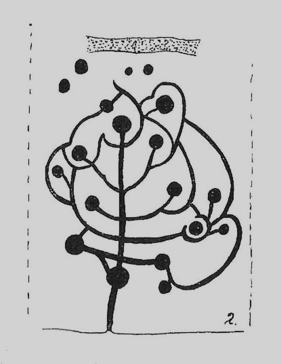
The most well-known and one of the more decorative of all the carvings in and around the Snowden Moor region is the Tree of Life Stone. In the 1930s, Eric Cowling first reported how, “this fine marking is the only one which appears to be known to the people of the district,” due in part to it being a site of local social activities (though nothing is said of this place in William Grainge’s [1895] survey). Cowling (1937) described the carving thus:
close-up of main featuresEric Cowling’s sketch
“This stone lies alongside the bridle path which skirts the southwest corner of the enclosed moorland above the hamlet of Low Snowden. A large flat rock surface at ground level has a number of cups joined together by a series of curved grooves, which in their turn are connected to a central straight groove. Immediately above the design, a broad groove has been cut across a raised central area as though to isolate the markings from several scattered cups which are to be found on the remaining surface.”
The modern surveyors Boughey & Vickerman (2003) tell us that this highly ornate stone comprises of,
“about 25 cups, with a group at the highest…end and a few isolated, but most in complex design with enclosing grooves suggesting a tree in fruit: hence the name ‘Tree of Life Rock.'”
The Tree of Life StoneBoughey & Vickerman’s sketch
The Coped Stone carving is just a few yards away and, on the slopes below here — as well as on the moor stretching above you — there is an excess of prehistoric remains: enclosures, hut circles, lengths of walling, cairns, other cup-and-ring stones — the vast majority of which has yet to be excavated in any formal sense (are any rich doods out there reading this who might wanna get things going…?). It appears that both the Coped Stone and the Tree of Life carving may have been linked by some ancient walling that appears to run between them.
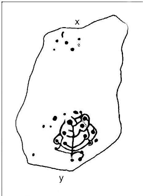
Another possible variant on the Tree of Life Stone has recently been uncovered on the outskirts of Ilkley; but on this newly-discovered example we find the central ‘trunk’ of the ‘tree’ is a natural crack that runs up the middle of the rock. Up the ‘trunk’ are several short branches with cup-marks on either side, not unlike apples on a tree. Altogether there are at least 12 cups and one ring, with several curious lines, some of which seem geophysical in nature. After several visits to the site, it’s obvious that the ‘tree’ design is more obvious and there are additional faint carved sections on the stone which weren’t visible when it was discovered in heavy rain and poor light.
This is one of very few cup-and-ring stones with folklore attached. Cowling (1937; 1946) reported it to be site of early morning Beltane (May 1) gatherings. The title of the stone, the Tree of Life, was one he heard local people call this site, but “no reason is offered”, he said. About 100 yards below this we find a curious erectile, fertility image on the impressive carving 612, which (he says tenuously!) may (and that’s a dodgy “may”!) relate to the Beltane rites at the Tree of Life.
Tree of Life in situ
In more modern folklore, the old earth mysteries writer Guy Ragland Phillips (1976) suggested the Tree of Life Stone to be an important focal point along one helluva highly speculative ley line: running from the Irish Sea, across land and the Tree of Life stone, continuing way east until hitting the North Sea! If this old ley did have any validity (it doesn’t!), the Tree of Life’s carved partners east and west of here — the Coped Stone and carving no.597 — would have also been on the same line.
References:
Boughey, Keith & Vickerman, E.A., Prehistoric Rock Art of the West Riding, WYAS 2003.
Cowling, Eric T., “Cup and Ring Markings to the North of Otley,” in Yorkshire Archaeological Journal, part 131, 33:3, 1937.
Cowling, Eric T., Rombald’s Way: A Prehistory of Mid-Wharfedale, William Walker: Otley 1946.
Phillips, Guy Ragland, Brigantia — A Mysteriography, RKP: London 1976.
Acknowledgements: Many thanks to James Elkington and to Yorkshire Daz for use of their photos.
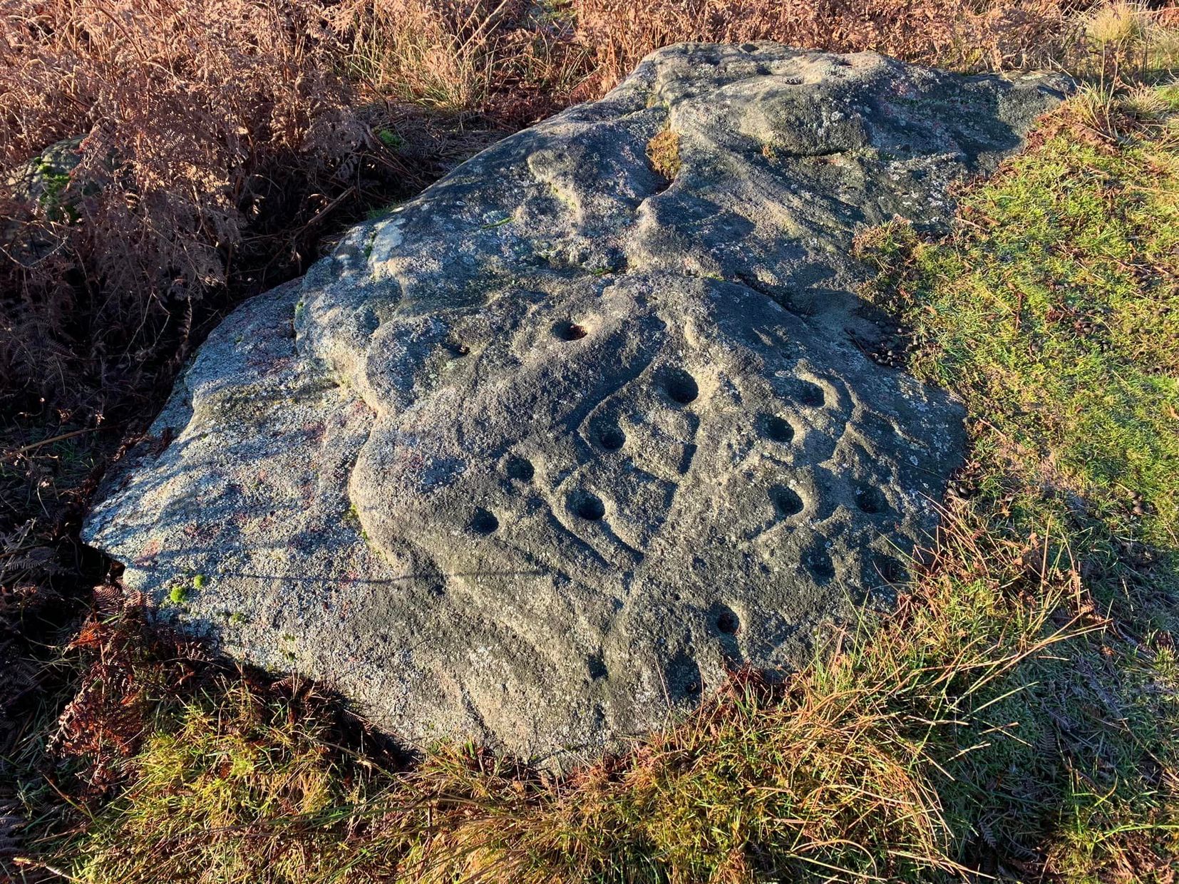
Not too difficult to locate if you don’t mind wandering to and fro in deep heather. From the Askwith Moor Road parking spot, walk up the road (north) 300 yards until you see the disused quarry on the moor to your right. From here, head onto the moor, straight down past the quarry for about 200 yards, angling slightly to your right. You’ll notice some overgrown ‘lumps’ in the heather — deemed as a cairnfield by archaeologists — go just below these and watch out for some rocks emerging from the heather. This carving (and its neighbours) is on one of ’em!
Archaeology & History
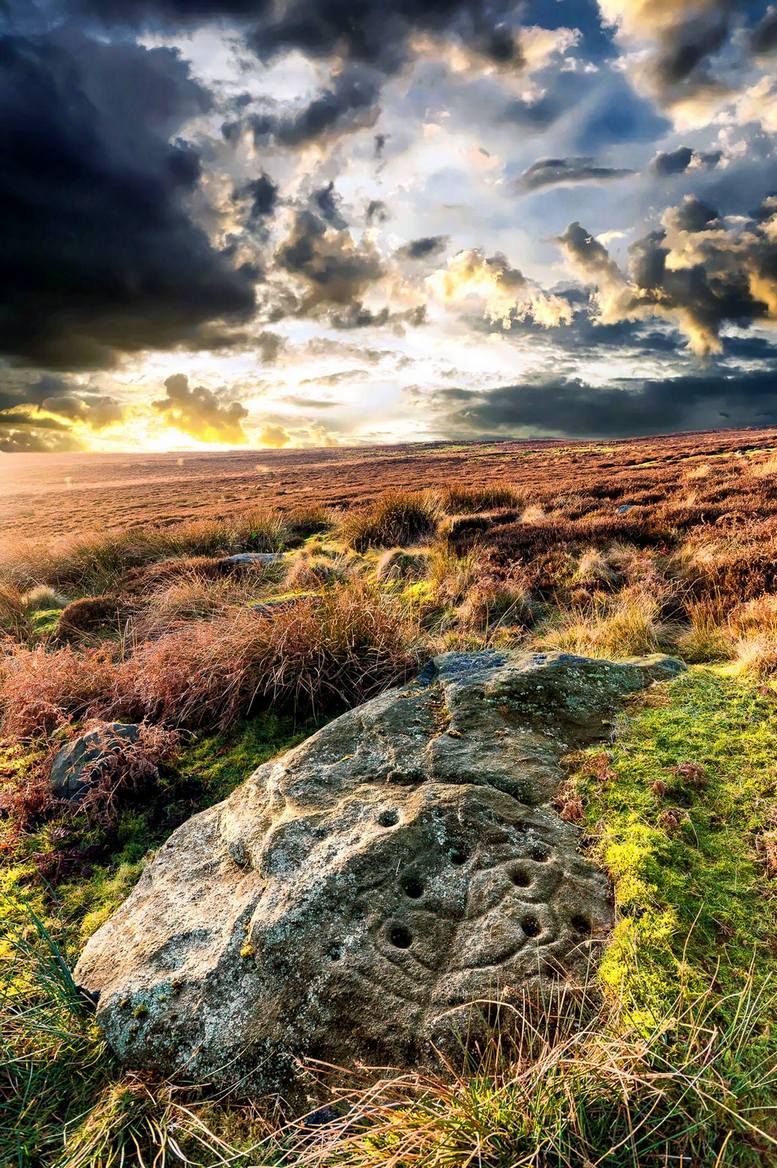
This curiously-shaped large rock has several worn cup-and-rings on its upper surface, with several cup-marks aswell. Two deeply etched lines running down the edge of the rock have also been pecked away as part of the carving, in contrast to the distinguishing natural water-worn line that runs diagonally along and down to the bottom of the stone.
The site was first described by Eric Cowling (1937), who labelled it as Carving no.9 in his survey, saying:
Carving 582, looking SWCarving from above
“At the eastern and lower end of the barrow group on Snowden Carr is a cluster of angular boulders, one of which has several markings cut on the upper surface. There is a cup and ring on the highest, and alongside two rings are joined together and enclose separate cups. One corner of the area is isolated by a groove running from edge to edge, and within this enclosure are three cups.”
Catalogued as ‘stone 582’ in Boughey & Vickerman’s (2003) survey, their description of the carving was one with “fourteen possible cups, several with indications of a ring, some of which intersect; grooves.”
References:
Boughey, Keith & Vickerman, E.A., Prehistoric Rock Art of the West Riding, WYAS 2003.
Cowling, Eric T., “Cup and Ring Markings to the North of Otley,” in Yorkshire Archaeological Journal, part 131, 33:3, 1937.
Cowling, Eric T., Rombald’s Way: A Prehistory of Mid-Wharfedale, William Walker: Otley 1946.