Tumulus (destroyed): OS Grid Reference – SD 7242 0899
Archaeology & History
This single-grave burial — described by Barnes (1982) as a kerbed or revetted cairn — close to the very centre of modern-day Bolton, was once an impressive prehistoric tomb. It was described by a local historian, Matthew Dawes, amidst a variety of prehistoric remains in and around Bolton, most of which have long-since been forgotten.
“Near Haulgh, about a quarter of a mile south-east from Bolton Parish Church, on a piece of high flat land, on the east bank of the Croal, and about fifty feet above the river, was a tumulus, about thirty feet in diameter, and four feet deep, consisting of small boulders… It was discovered in September, 1826, in forming a branch of the new road leading from Bolton to Bury. It was probably much depressed in its formation and was covered with a few inches of mound. The cop or fence crossed it in a north and south direction. About the centre of this tumulus was a cist-vaen, about four feet six inches long and one foot deep, formed of four upright stones and a coverer, and its length was nearly north and south. In this cist-vaen was a skeleton, with the legs doubled up, and the head to the north. Near the head, and on the west side, was found an urn, inverted, four and a half inches in the widest diameter, and three and a quarter inches high, and perforated by four small holes in the widest part. On the other side of the head was a bronze spear-head, four and three-eighths inches long, and one and three-eighths inch wide, of which the point was bent back, and a piece of the side chipped away. The urn and spear-head were taken to the Countess of Bradford, the Earl of Bradford being the owner of the land.”
Intriguingly, if you’re from the Bolton region, Mr Dawes also told that, “A man in the employ of the Earl of Bradford, the superintendent of the work, who made the discovery, informs me (1862) that two other tumuli were found shortly after the one just described, a few yards to the south of it, in the same fence.” As yet I have no more information about these other tombs (gimme time though!)
References:
Barnes, Bernard, Man and the Changing Landscape, Unversity of Liverpool 1982.
Dawes, M., ‘British Burial Places near Bolton,’ in Trans. Hist. Soc. Lancs & Cheshire, volume 4, 1852.
Scholes, James C., History of Bolton, Daily Chronicle: Bolton 1892.
Pretty simple really. Go up the B6265 Skipton-Rylstone road for about 3 miles, past the Nettlehole Ridge woodland on your right. The next turn along to your right, up the track, is Scale House. Go past this until you get to Scale House Farm. The remains of the burial mound is in the field to your left, just before the farm. Knock on the door and ask!
Archaeology & History
This ‘tumulus’ (as it’s marked on the OS-map) was one of the many explored by the legendary reverend William Greenwell (1864) in the middle to latter-half of the 19th century. His description of the finds at Scale House were considerable; thankfully our old Yorkshire antiquarian Edmund Bogg (1904) shortened it and told us the following:
“The tumulus was 31 feet in diameter and about 7 feet high; it opened from the southeast; the soil immediately under the sod consisting of yellow clay to a considerable depth; then layers of blue clay… Exactly in the centre…at a depth of 7 feet, and on a level with the plane of the field, was found an oak coffin, formed out of a tree, split and hollowed-out, and placed due north and south, the head being placed to the south, as that as the larger part of the tree. After being exposed to the air for about 2 minutes, the bared coffin parted at the sides, and could not be moved except by detached pieces. The body had been wrapped in a cloth or shroud of texture resembling wool and coarsely-woven, of which there was a considerable quantity remaining; but the body itself was dissolved… The interment was considered to be that of an ancient Briton… The learned antiquary said it was the only instance (except the one at Gristhorpe, near Scarborough) where an interment in an oak tree hollowed out had a tumulus placed over it. It was more than 6 feet in length inside and about 7 feet 6 inches outside. The remains were carefully replaced and the mound restored to its former shape; a small leaden tablet being placed within, stating that it had been opened in AD 1864.”
Folklore
Jessica Lofthouse (1976) listed this as one of the places reputed to be an old fairy haunt, wherein “the folk of Scale House discovered a fairy kist or chest.”
References:
Bogg, Edmund, Higher Wharfeland, James Miles: Leeds 1904.
Greenwell, William, British Barrows, Clarendon Press: Oxford 1877.
Lofthouse, Jessica, North Country Folklore, Hale: London 1976.
Follow the same directions for getting to the Black Hill Round Cairn. It’s less than 100 yards away – you can’t miss it!
Archaeology & History
This is a superb archaeological site — and it’s bloody huge! It’s big and it’s long and it sticks out a bit – which is pretty unique in this part of the Pennines, as most other giant cairns tend to be of the large round variety. Although the site was originally defined by Arthur Raistrick (1931) as a long barrow, J.J. Keighley (1981) told how, “it was found to be a round cairn imposed on a long cairn.” And it’s an old one aswell…
Near the SE end of the giant cairnClose-up of the main cist
More than 220 feet long and 80 feet in diameter at its widest southeastern end, as we walk along the length of the cairn to its northwestern edge, its main body averages (only!) 45 feet in diameter. Made up of tens of thousands of rocks and reported by Butterfield (1939) to have had an upright stone along its major axis, the “height varies from 4-8ft, but the cairn has been much despoiled and disturbed,” said Cowling in 1946. He also told how,
“Excavation revealed that almost in the centre of the mound were the remains of a cist made of roughly dressed stone flags and dry walling, covered by a large stone. Under a stone slab, laid on the floor of the cist, were fragments of (burnt and unburnt) bone and a small flint chipping.”
This is a very impressive site and deserving of more modern analysis. The alignment of the tomb, SE-NW, was of obvious importance to the builders, believed to be late-neolithic in character. The tomb aligns to two large hills in the far distance in the Forest of Bowland which we were unable to identity for certain. If anyone knows their names, please let us know!
Folklore
The older folk of Bradley village below here, tell of the danger of disturbing this old tomb. In a tale well-known to folklorists, it was said that when the first people went up to open this tomb for the very first time, it was a lovely day. But despite being warned, as the archaeologists began their dig, a great storm of thunder, lightning and hailstones erupted from a previously peaceful sky and disturbed them that much that they took off and left the old tomb alone. (I must check this up in the archaeo-records to see if owt’s mentioned about it.)
References:
Ashbee, Paul, The Earthen Long Barrow in Britain, Geo Books: Norwick 1984.
Butterfield, A., ‘Structural Details of a Long Barrow on Black Hill, Bradley Moor,’ in YAJ 34, 1939.
Cowling, E.T., Rombald’s Way, William Walker: Otley 1946.
Keighley, J.J., ‘The Prehistoric Period,’ in Faull & Moorhouse’s West Yorkshire: An Archaeological Survey, I, WYMCC: Wakefield 1981.
Raistrick, Arthur, ‘Prehistoric Burials at Waddington and Bradley,’ in YAJ 30, 1931.
Although I describe this site in association with the township of Kilmartin, it is in fact several miles north of there – but I reckoned that if I say it’s near Kilmartin, then those of you who don’t really know this region, will have some idea of its locale. So – from Lochgilphead, go up north thru Kilmartin, another coupla miles on, till you reach the small road to your right (signposted ‘Ford’). Just keep driving for a couple more miles until you hit the village. If you park by the only shop, you’re just past the old tomb. Diagonally across on the opposite side of the road from the Ford Hotel, right by the road-junction, just before the little shop, you’ll see a notable rounded mound overgrown in shrubs. Embedded in this are the remains of an old tomb.
Archaeology & History
Ford tumulus (photo, couresty J. Reid)
This typical-looking fairy-mound just by the road junction in the village is where me and my daughter used to scramble around, sometimes playing and sometimes seeing if we could find anything of note in this ancient hillock, but all trace of any prehistoric stonework seems to be well-buried. When excavators explored the site in bygone times, a small stone cist was found, which aligned (yet again) north-south and measured internally, roughly, 3ft x 2ft. Only small!
A food vessel in Edinburgh’s central museum, “found in a cist in the neighbourhood of the lower end of Loch Awe” is thought to have come from this tomb.
References:
Royal Commission on the Ancient & Historical Monuments of Scotland, Argyll – volume 6: Mid-Argyll and Cowal, HMSO 1988.
An old stone-lined burial cist could once be seen in this locale: reported in 1953 to have been “discovered in the southwest corner of a field south of Druimyeonbeg farmhouse.” When it was uncovered by the farmer, the covering capstone was missing. Any relics that may have been there were destroyed and there’s now no trace of anything.
References:
Royal Commission on the Ancient & Historical Monuments of Scotland, Argyll – Volume 1: Kintyre, Glasgow 1971.
In Thomas Pennant’s A Tour in Scotland and Journey to the Hebrides, 1772 (1790:226), he described there being three prehistoric cairns about four-hundred yards west of Ardminish, or a couple or hundred yards north of the Achamore Standing Stone, on Cnoc na Croise, but they seem to have been destroyed. At least two of them were between 4 and 5 yards across and contained cists. A search for the site by the Royal Commission lads in the 1960s found nothing—although they may have been looking in the wrong place (the grid reference given above is an approximation). Does anyone know anything more about these seemingly lost sites?
References:
Royal Commission for Ancient & Historical Monuments of Scotland, Argyll – volume 1: Kintyre, HMSO 1971.
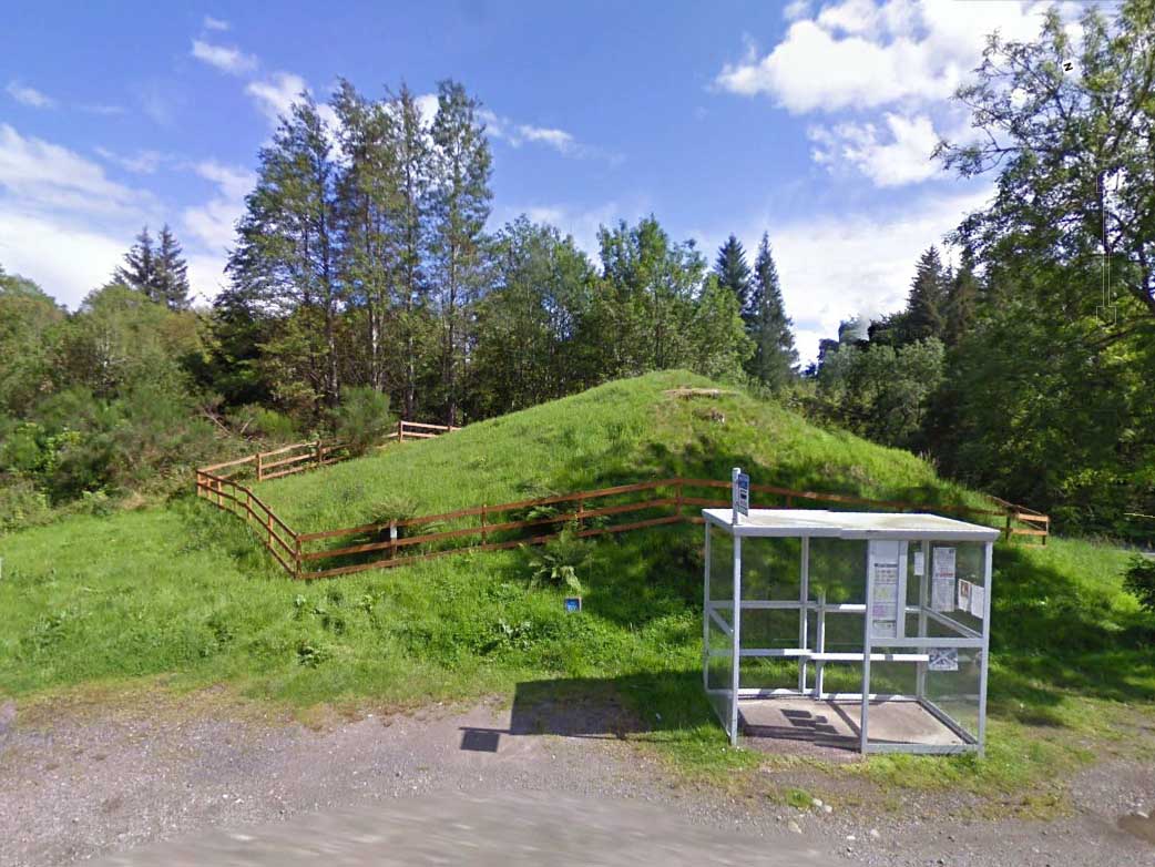
Various routes to this giant tomb, which happens to be a way off the roads (thankfully!). Probably the easiest way is from the Menston-side: up Moor Lane, turn left at the end, go 200 yards and take the track onto the moor. Just keep walking. If you hit the rock-outcrop nearly a mile on, you’ve gone past your target. Turn back for about 400 yards and walk (south) into the heather. You’re damn close!
Archaeology & History
Great Skirtful of Stones cairn looking east to Otley Chevin
Due north of the Skirtful Spring water source, this is one of Ilkley Moor’s major prehistoric sites: ‘major’ for a number of reasons – not least of which is the size of the thing! Although getting somewhat overgrown these days as more of the heathlands encroach the mass of rocks that constitute the central ‘tomb’, it is still a formidable heap. Another reason this site is of importance is its position in the landscape: it can be seen as the peak or ‘nipple’ on the landscape from considerable distances north, south and east of here, rising up on the horizon and catching the eye from many miles away. This was obviously quite a deliberate function of the site when it was first constructed – thought to be in the Bronze or Iron Age period (sadly we have no decent excavation here to tell us just when it was made). Another reason for its importance is its position relative to a once huge prehistoric graveyard immediately east. And right next to it we also find a curious circular monument that has never been properly excavated, whose function is unknown. It is also the seeming focal point of at least one, though possibly three prehistoric trackways: one of which goes right past it, though swerves on its southern edge quite deliberately so as to not touch the monument. This trackway appears to have been a ceremonial ‘road of the dead,’ along which our ancestors were carried, resting for some reason at the nearby Roms Law, or Grubstones Circle, a few hundred yards to the west.
Wrongly ascribed as a “round barrow” by archaeologist Tim Darvill (1988), the Great Skirtful cairn was named in boundary changes made in 1733, where one Richard Barret of Hawksworth told that the site was “never heard go by any other name than Skirtfull of Stones.”
In 1901 there was an article in the local ‘Shipley Express‘ newspaper — and repeated in Mr Laurence’s (1991) fine History of Menston and Hawksworth — which gave the following details:
“Mr Turner led the way across Burley Moor to the Great Skirtful of Stones, a huge cairn of small boulders, nearly a hundred tons on a heap, although for centuries loads have been taken away to mend the trackways across the moor… The centre of the cairn is now hollow, as it was explored many years ago, and from the middle human bones were taken and submitted to Canon Greenwell and other archaeologists” – though I have found little in Greenwell’s works that adequately describe the finds here. Near the centre of the giant cairn is a large stone, of more recent centuries, which once stood upright and upon which is etched the words, “This is Rumbles Law.” The Shipley Express article goes on: “Mr Turner explained that ‘law’ was always used in the British sense for a hill, and Rumbles Hill, or cairn, was a conspicuous boundary mark for many centuries. He had found in the Burley Manor Rolls, two centuries back, that on Rogation Day, when the boundaries were beaten by the inhabitants, they met on this hill, and describing their boundaries, they concluded the nominy by joining in the words, “This is Rumbles Law.””
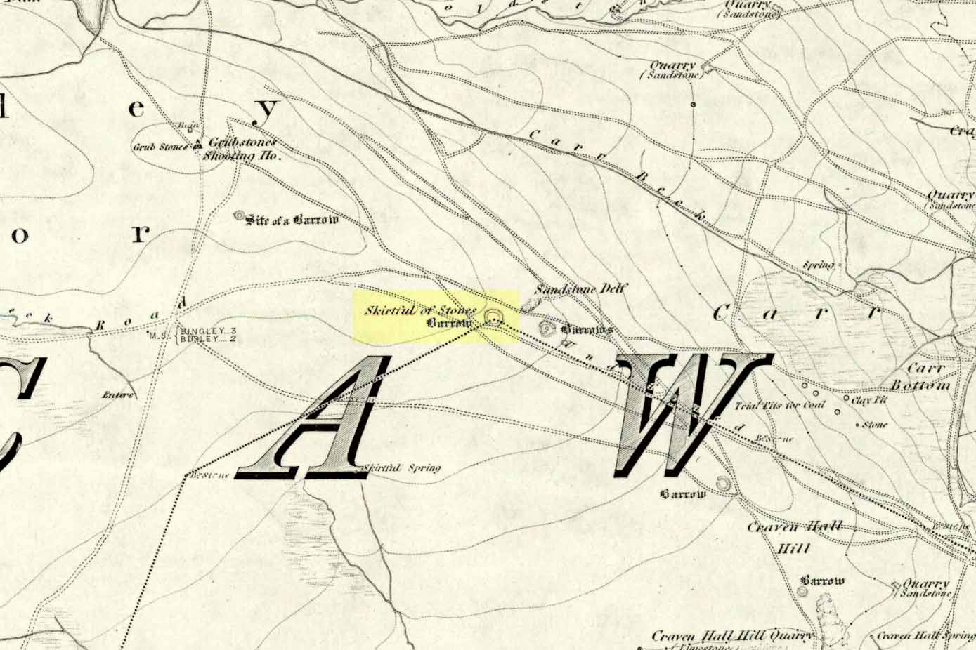
Great Skirtful on 1851 map
Several other giant cairns like this used to be visible on the moors, but over the years poor archaeological management has led to their gradual decline (and in editing this site profile in 2016, have to report that poor archaeological and moorland management is eating into and gradually diminishing this monument to this day). We still have the Great Skirtful’s little brother, the Little Skirtful of Stones, a half-mile north of here. The very depleted remains of the once-huge Nixon’s Station giant cairn can still be seen (just!) at the very top of Ilkley Moor 1½ miles (2.65km) west.* And we have the pairing of the giant round cairn and long cairn a few miles west on Bradley Moor, near Skipton. The tradition of such giant tombs on these hills was obviously an important one to our ancestors.
Folklore
We find a curious entry in the diaries of the Leeds historian Ralph Thoresby, in the year 1702, which seems to describe the Great Skirtful of Stones, adding a rather odd bit of folklore. (if it isn’t the Great Skirtful, we’re at a loss to account for the place described.) Mr Thoresby told how he and Sir Walter Hawksworth went for a walk on Hawksworth’s land and said how,
“he showed us a monumental heap of stones, in memory of three Scotch boys slain there by lightning, in his grandfather’s, Sir Richard Hawksworth’s time, as an old man attested to Sir Walter, who being then twelve years of age helped to lead the stones.”
As far as I’m aware, this old story of the three Scottish boys is described nowhere else.
Like many giant cairns, the Great Skirtful has a familiar creation myth to account for its appearance. In one version we hear that it was made when the local giant, Rombald (who lived on this moor) and his un-named wife were quarrelling and she dropped a few stones she was carrying in her apron. A variation swaps Rombald’s wife with the devil, who also, carelessly, let the mass of stones drop from his own apron to create the ancient cairn we still see today.
According to Jessica Lofthouse’s North Country Folklore (1976), a Norse giant by the name of Rawmr, “fell fighting against the Britons of Elmet and is buried, they say, on Hawksworth Moor” – i.e., the southeastern section of Rombald’s Moor, very probably at the Great Skirtful of Stones. I’ve yet to explore the history and etymology of the name Rawmr…
References:
Bennett, Paul, The Old Stones of Elmet, Capall Bann: Chieveley 2001.
Cowling, Eric T., Rombald’s Way, William Walker: Otley 1946.
Darvill, Timothy, Ancient Britain, AA: Basingstoke 1988.
Laurence, Alastair, A History of Menston and Hawksworth, Smith Settle: Otley 1991.
* Whoever is/was supposed to be responsible for the care of the Nixon’s Station giant cairn monument should be taken to task as it’s been virtually obliterated since when I first came here 30 years ago. Which useless local archaeologist and/or council official is responsible for its destruction? Who allowed it to happen? Why are Ilkley Moor’s prehistoric monument’s being so badly looked after by those who are paid to ensure their maintenance? Are their heads up their arses, in the sand, or—don’t tell me—the prawn sandwiches are to blame!?
A decent-sized cairn, around 50 feet across (even though much of the stone has been nicked) and about 3 feet high, with a singular large cist near its centre. When the Scottish Royal Commission lads checked the place out in 1967, at least four of the kerb stones were still in situ (on its north, west and southwest sides) – the tallest being its northern stone, more than 6 feet high. The northern stone also had a peculiar deposit of white quartz and pebbles laid at the base, placed there quite deliberately – unlike the others which rested on a level of sand and gravel.
The Scottish Royal Commission (1971) also reported the former existence of two cists not far from here, “uncovered by the plough during the 19th century on the farm of Ardlamey”: one at NR 637 484, and the other at NR 635 484.
References:
Royal Commission on the Ancient & Historical Monuments of Scotland, Argyll – Volume 1: Kintyre, Glasgow 1971.