Craigenfeoch, Johnstone, Renfrewshire

Cup-and-Ring Stone:  OS Grid Reference – NS 4361 6173

Also Known as:

  1. Canmore ID 43233
  2. Craigton Woods Carving

Getting Here

The TNA Rock Art Team on site
The TNA Rock Art Team on site – Fraser, Frank, Lisa, Leo & Aish

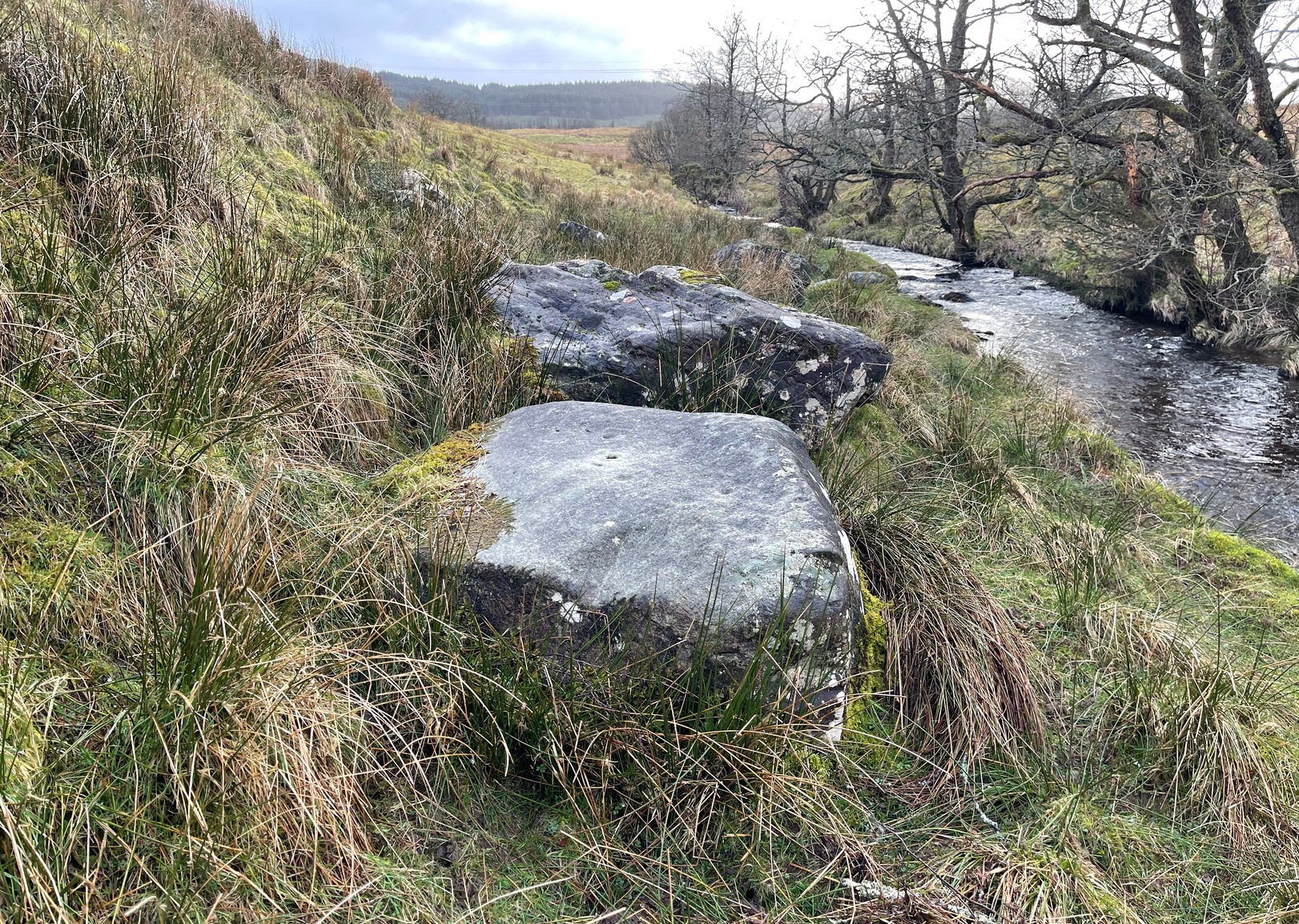
Get yourselves to Johnstone or Elderslie (which just about fuse into each other) and off the B789 road, make your way to Johnstone Castle football ground on Auchenlodment Road and go uphill, past the housing estate, until the fields open up on either side. 350 yards further, woodland appears.  Go past the hair-pin kink in the road and, 50 yards or so past this, walk into the trees on your right.  About 20 yards in, a large sloping rock face is what you’re looking for… (there’s a decent car-park on the left-hand side of the road 400 yards further along if you’re driving here)

Archaeology & History

4 cup-and-rings in poor light

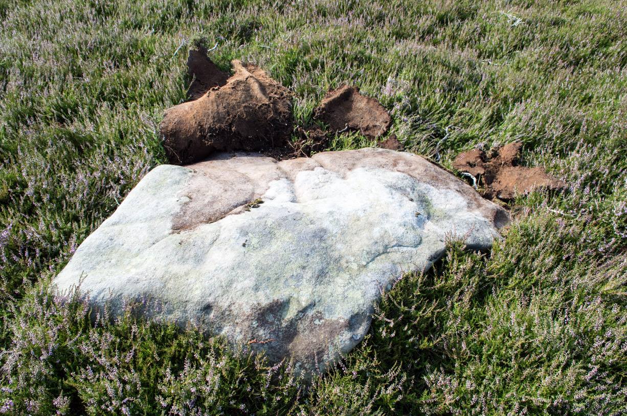
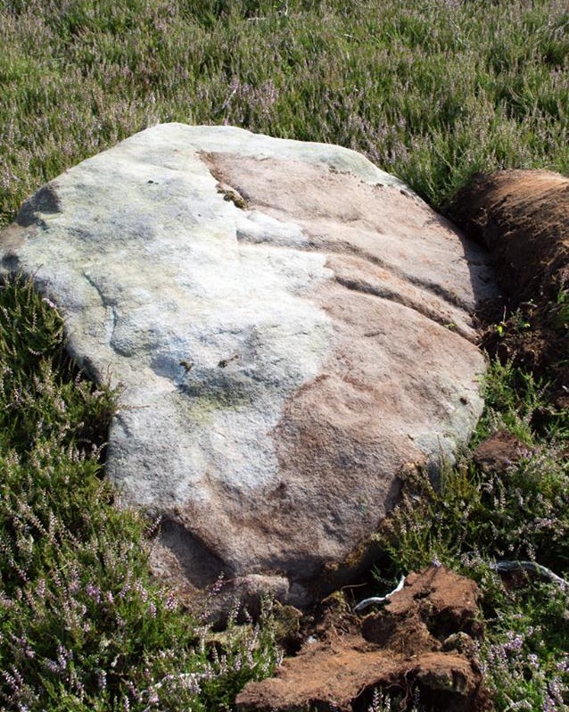
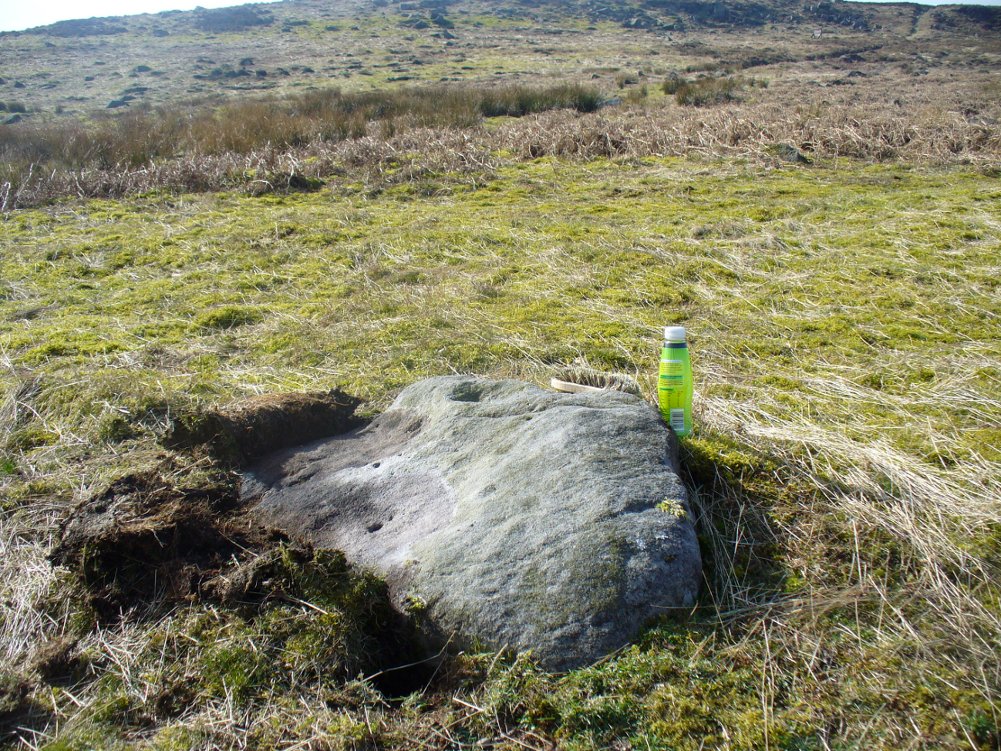
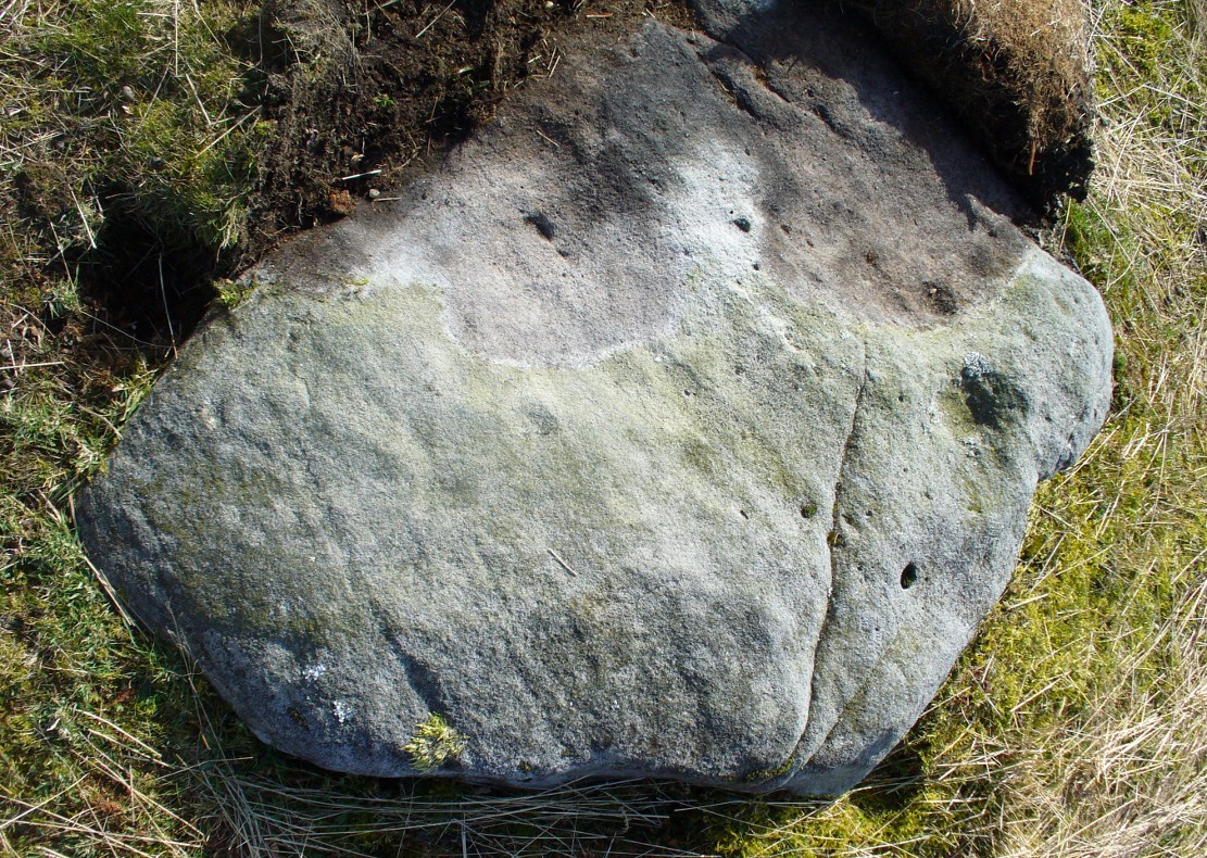
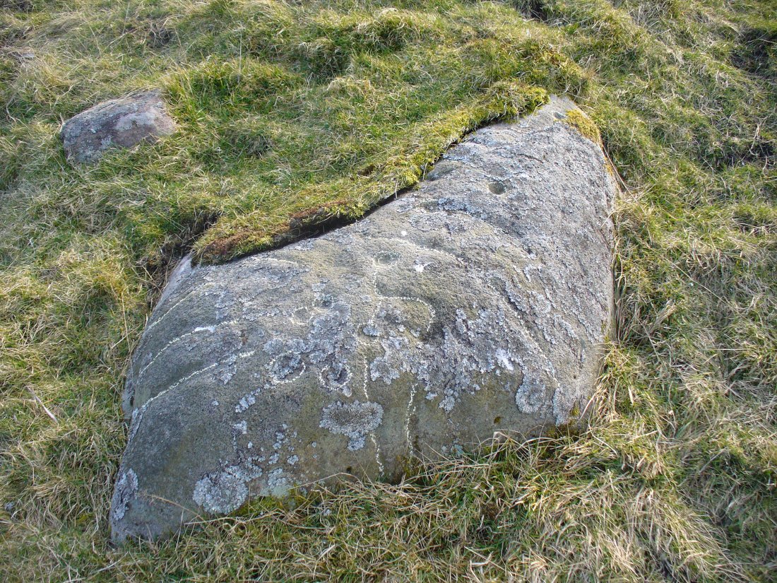
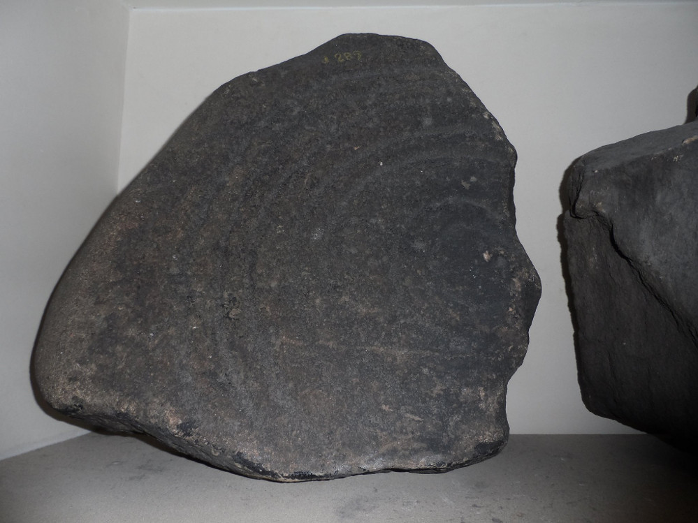
A seemingly solitary but vandalised petroglyph at the top of the Craigton Woods above Johnstone Castle estate: vandalized by the industrialists, whose quarry cut into a once larger rock, at whose edges cup-markings exist and whose design extended much further onto the now-vanished rock.  The carving was also painted onto by some ignorant bastard many years ago (as the photos show); and one of the cup-and-rings here has either been damaged or isn’t prehistoric.  The paint was daubed onto the stone in the 1960s and is shown in one of Ron Morris’ (1981) several descriptions of the site; and whilst it interferes with the design, it hasn’t damaged it anything like as badly as the industrialists have done.

Craigenfeoch cup-and-rings

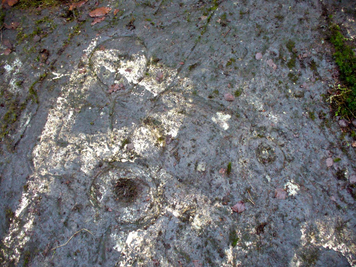
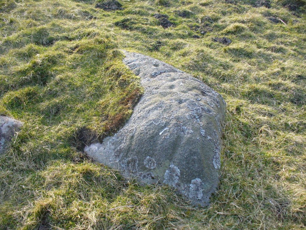
Vandalism aside: it’s still quite an impressive carving, albeit hidden in the shadows of the surrounding trees. The design has been etched onto a large rock, some 35 feet long and perhaps up to 10 feet across, sloping at an angle of about 30-35° down (slippery when wet, as we all found out!).  When we visited the site a few days ago, low cloud and mist didn’t really allow us a decent inspection of the site.  But what we did find was more than our predecessors….

James Kirkwood (1938) gave the first literary account of the site—and in some detail. When he found the place it was “mostly covered with vegetation”, much like we found it on our visit.  He wrote:

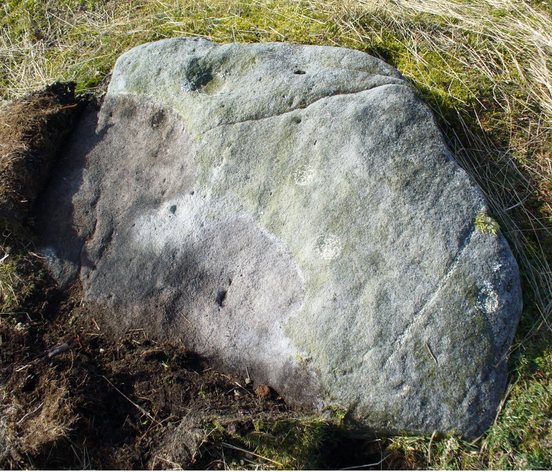
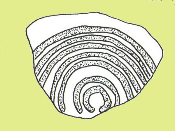
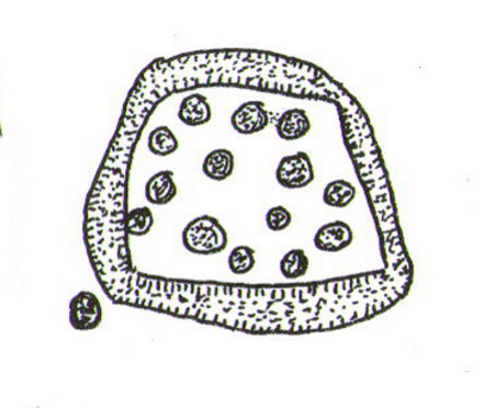
“The group of markings comprises five cups, each surrounded by a single encircling ring, whole lay-out being contained in an area of about 9 square feet.  The setting corresponds almost exactly with the four cardinal points of the magnetic compass.  The cup and ring to the north is the best preserved, the cup being 2½ inches in diameter and cut to a depth of 1 inch; the ring is somewhat elliptical, measuring 8½ and 7½ inches on its major and minor axes.  A channel or gutter connects this cup with that within the eastern ring.  The remaining cups vary from 2 inches to 2½ inches in diameter, and the rings from 6½ to 7 inches diameter.  It is significant that the east and west cups are equidistant from the north one at about 15¼ inches; they are also equally spaced from the southeast cup at 19½ inches, and this latter dimension measures the distance from the west to the southwest cup. The four cups and rings on the main cardinal points are all moderately distinct, but the southwest sculpturing can only be very faintly discerned.”

James Kirkwood's drawing
James Kirkwood’s drawing
Ron Morris' sketch
Ron Morris’ sketch

Kirkwood’s fascination with the alignments and measurements betwixt certain elements on the petroglyph was something of a fad at the time (resurfacing with some vigour in some quarters today), but is likely to have little if any authentic relevance with the animistic dynamics implicit in the function of the design.

When Ronald Morris (1981) entered the carving into his Southern Scotland survey, he made the now standard bland description of the carved elements:

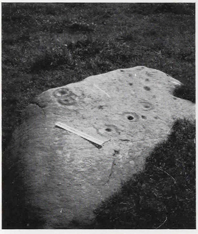
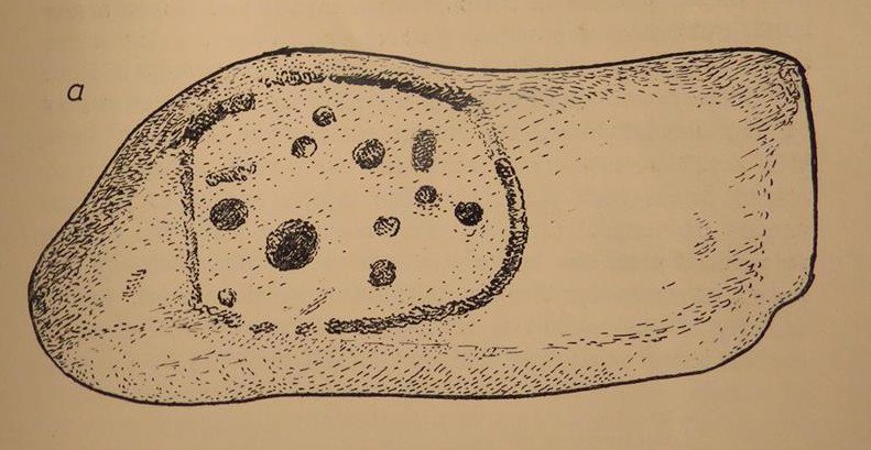
“At least 5 cups-and-one-complete-ring (some ovoid), at least one with a long wavy groove downhill from the ring, and at least 5 cups, some of which may have been ringed.  The ring marked ‘F’ in the (black-and-white photo, below) has been ‘improved’ since 1934 — the author has an older photograph showing it similar to the others.  The 2 upper rings can only be seen just after sunrise, when wet—they are much weathered.  Greatest ring diameter – 17cm (7in) and carving depths up to 2cm (1in).”

Fraser, Frank & Lisa at work

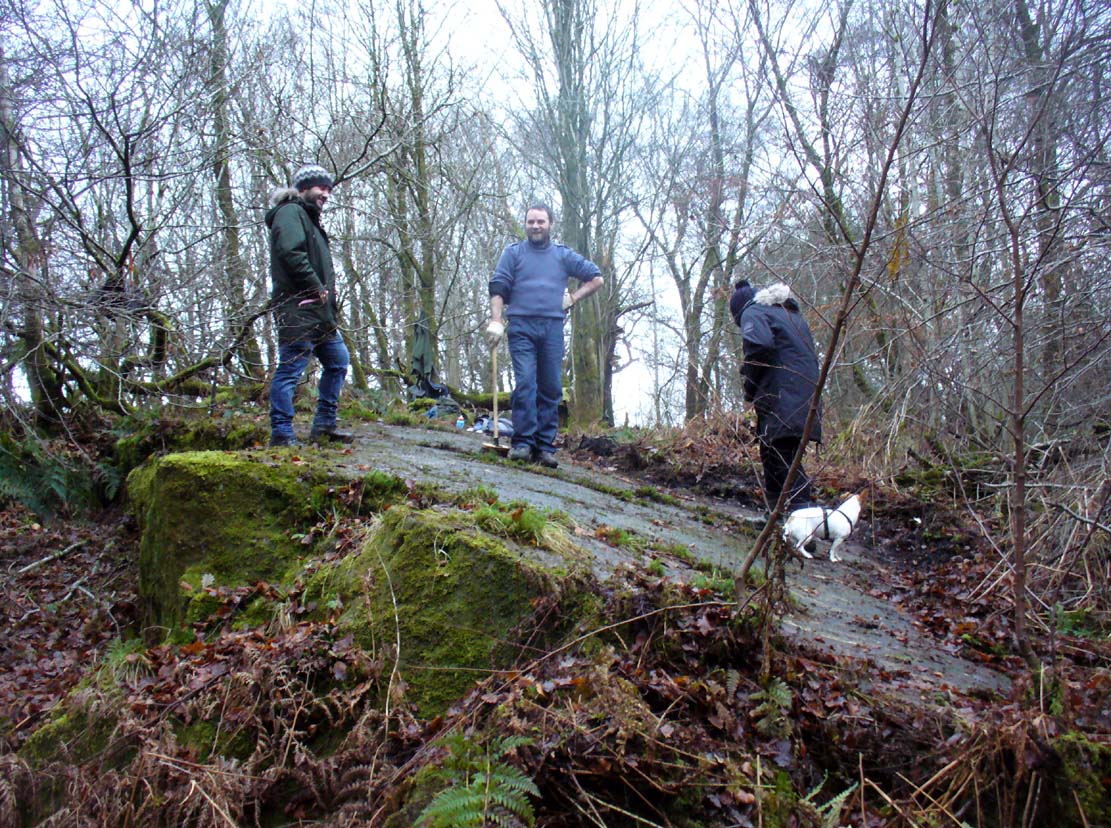
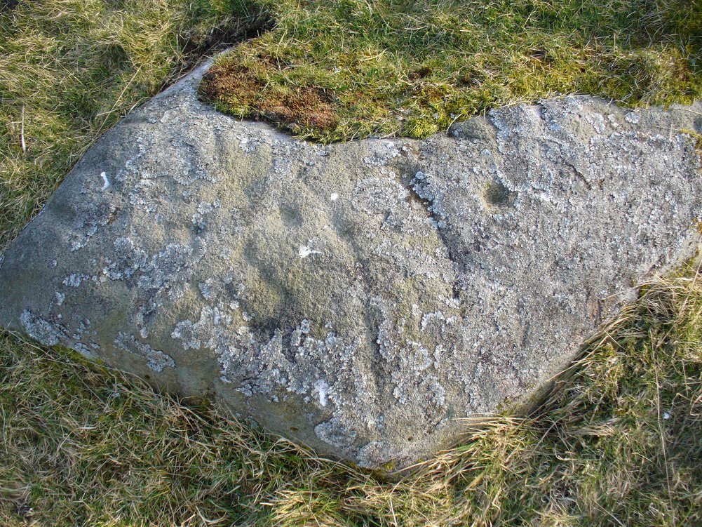
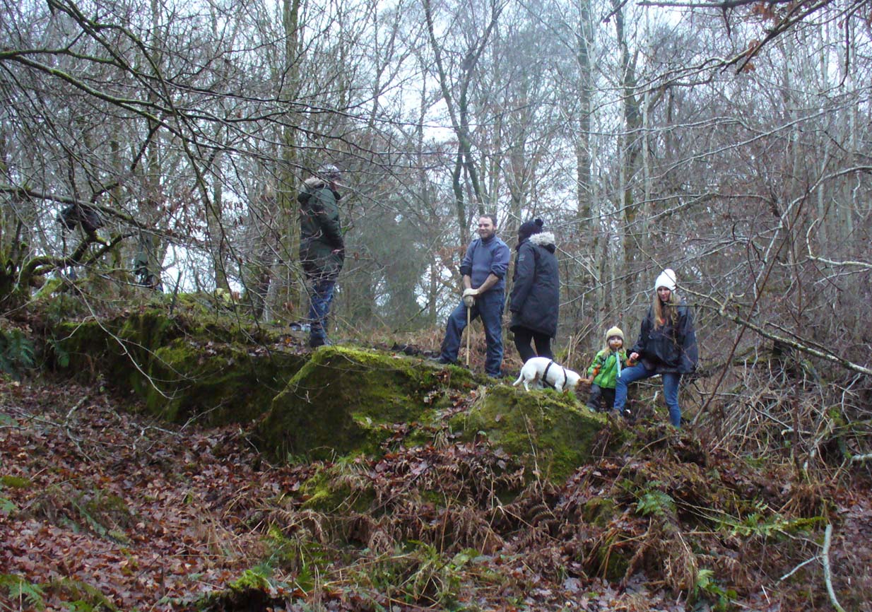
A good drawing of the carving would be worthwhile (are there any rock art-ists out there wanna join us on our next visit?), as the archaeological blandness never does petroglyphs descriptive justice.  Ostensibly, from the bottom slope of the elongated stone—below where Fraser, Frank and Lisa are standing, right—a number of geophysical marks run across the stone.  You can see in the photo how several geophysical ‘lines’ cut across the rock at an angle, roughly parallel, marked by the green vegetation.  One of these is a small natural tunnel hole running through the stone, possibly made by the softer rock of a fossilized tree root or branch which has since disintegrated over time.  Just above this ‘hole’ the carvings begin.

Cup-and-ring & carved line
Outer cup, 'fan' & CnRs
Outer cup, ‘fan’ & CnRs

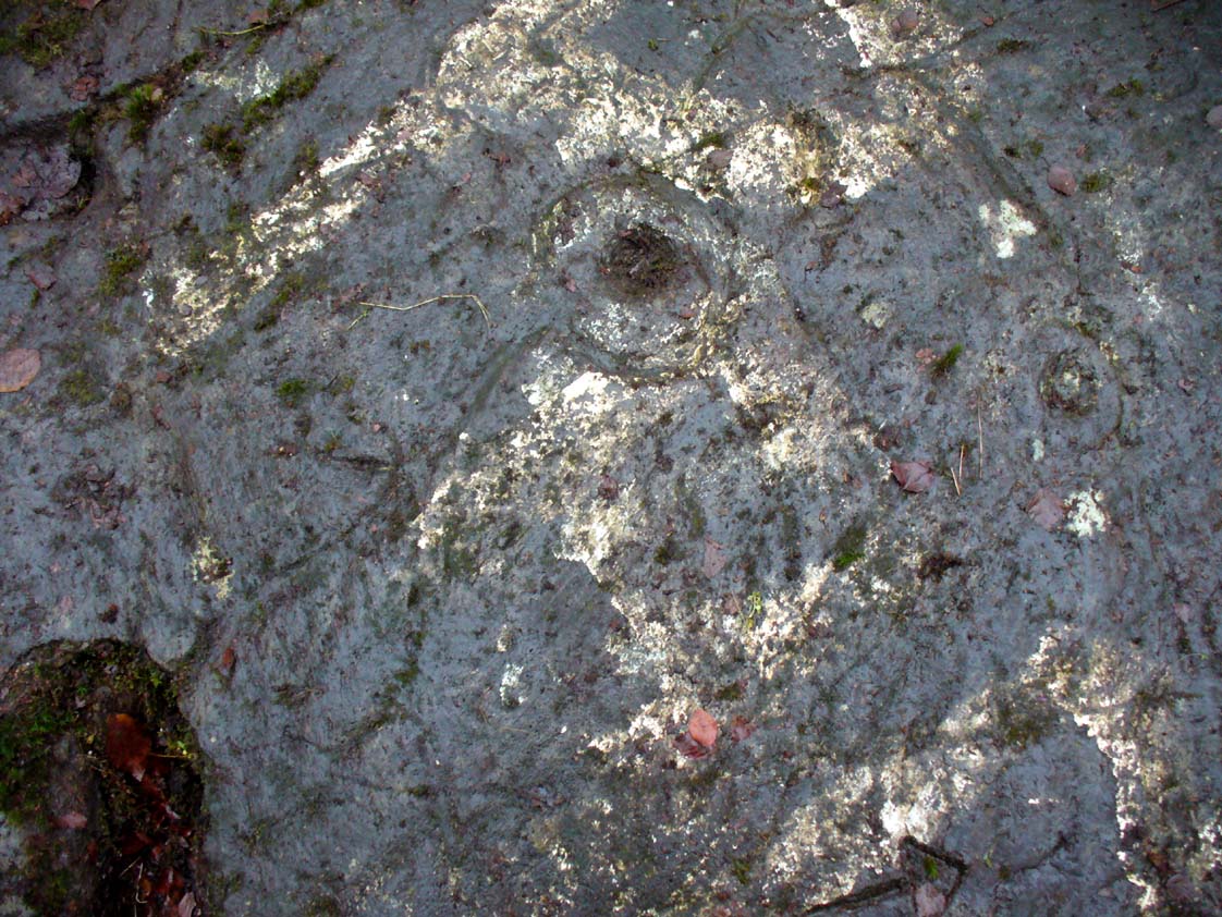
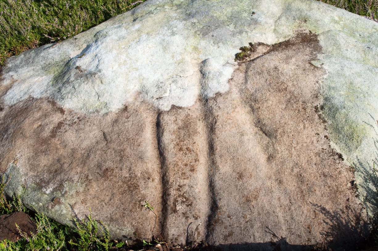
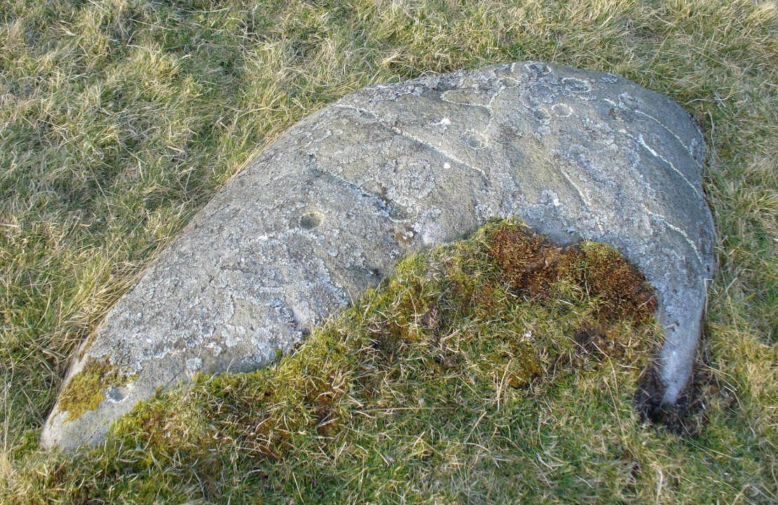
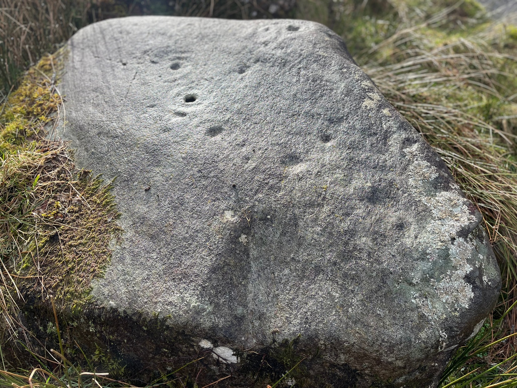
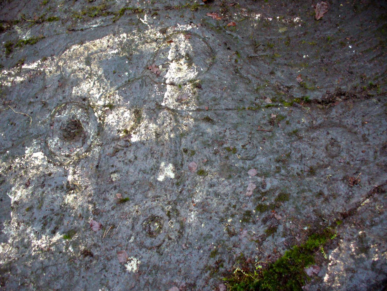
A number of possible cup-marks are overshadowed by the definite series of well eroded cup-and-rings (at least four of them) all close to each other, with lines connecting some to the others, including one which runs down to the tunnel hole.  Some other lines on this part of the rock may or may not be geophysical (is there a geologist in the house!?).  Close to the edge of the stone (where Fraser stands in the photo above) a singular cup-mark has been etched within a series of five lines, like an open fan, that all run to a point at the entrance of the natural tunnel in the stone.  We were unsure as to whether these lines were natural or man-made (we need that geologist!); but it should be noted that an element very similar to this ‘fan’ of lines occurs in a carving near Killin, Perthshire, which we have yet to fully excavate—and in the Killin example the lines reach out from a central point like spokes on a bike wheel to an entire surrounding ring of cup-and-rings!  Intriguing…

R.W.B. Morris early photo

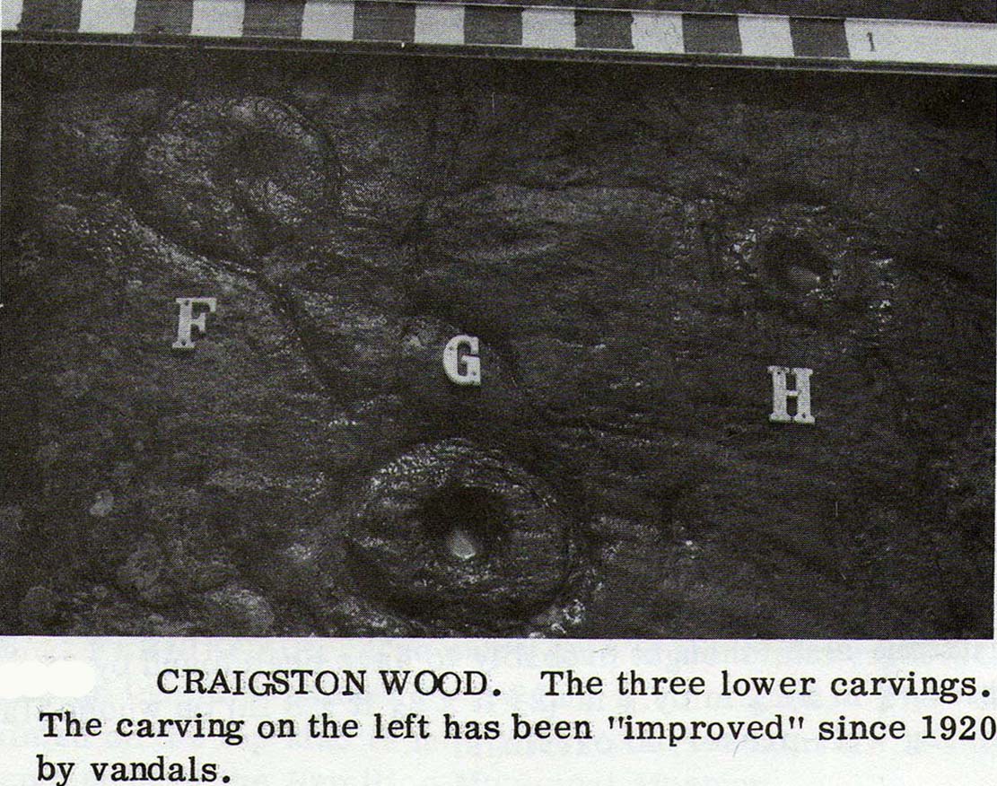
One of the cup-and-rings in this cluster has clearly been either vandalized or else carved within the last century, as the erosion on it is wholly different to the rest, and the angle of the cuts into the stone shows clearly that a metal tool has made it.  However, as Ron Morris stated above, this was apparently not the case with this ‘ring’ when he visited it in 1934 (it would be good to see the photo which he says shows its original state).

Faint cup-marks halfway up

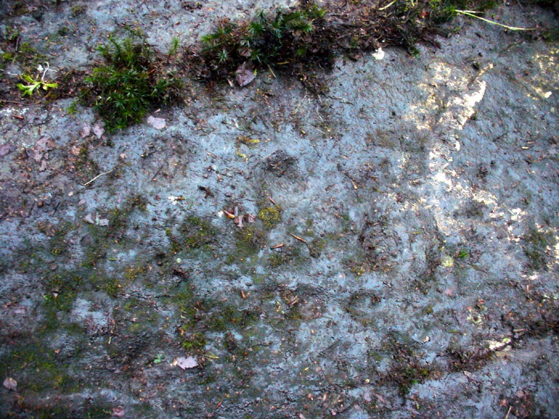
Further up the slope of the rock we reach a near-parallel row of natural cracks across the stone.  Inside this, about halfway along, a cluster of well eroded cup-marks exist—at least four of them.  One of them has either a curved line arching out of it, or a semi-circular arc.  Above the parallel cracks there is a large and very well eroded cup which, from differing angles, appeared to have faint sections of a ring around it, but we all agreed this was more a Rorschach response in our respective feeble minds!

We need to visit the site again in much better weather to gain a more accurate picture of the entire design.  It appeared there were other elements to be seen here, but the lighting conditions were working against us that day…. That’s our excuse anyway!

References:

  1. Kirkwood, James, “Notes on Cup and Ring Markings at Craigenfeoch, Renfrewshire”, in Transactions of Glasgow Archaeological Society, 9:2 (New Series), 1938.
  2. Morris, Ronald W.B. & Bailey, Douglas C., “The Cup-and-Ring Marks and Similar Sculptures of Southwestern Scotland: A Survey,” in Proceedings of the Society of Antiquaries, Scotland, volume 98, 1966.
  3. Morris, Ronald W.B., “The Cup-and-Ring Marks and Similar Sculptures of South-West Scotland,” in Transactions of the Ancient Monuments Society, volume 14, 1967.
  4. Morris, Ronald W.B., The Prehistoric Rock Art of Southern Scotland, BAR: Oxford 1981.

Acknowlegdments:  With huge thanks to what Nina Harris called “the TNA rock art team” – Aisha Domleo (and Leo), Nina Harris, Frank Mercer, Lisa Samsonowicz & Fraser Harrick.

© Paul Bennett, The Northern Antiquarian 


Forty Acres (3), Stelling, Marske, North Yorkshire

Cup-and-Ring Stone:  OS Grid Reference – NZ 0758 0058

Getting Here

Surface of Forty Acres 3 carving
Surface of Forty Acres (3) CnR

From Marske village, take the road west and uphill to the villages of Fremington and Reeth.  At the top of the hill where the fields open up, several hundred yards along on your right, past the field with the track, a footpath sign points you up onto the moor. Go up the field till you hit the wall that goes right to the top of the moor. Where the four walls meet, go straight across and then walk northwards along the line of walling for 2-300 yards, keeping your eyes peeled for a solitary stone on its own, 100 yards west.  You’ll find it.

Archaeology & History

Deep carved line features

A pretty basic petroglyph located within a massive arena of prehistoric sites dating from the neolithic and continuing through the Bronze Age period and beyond.  Found a few hundred yards northwest of the once giant cairn of Cock Howe, this design is characterized mainly by the two large deep channels deliberately cut into the stone that run from the middle of the upper surface down to ground level.  One of them emerges from a single cup-marking, at an angle; whilst the other comes from the edge of a natural crack in the rock.  The channels are wide and flattened. Other faint lines can be discerned too, which may have originally been carved.  We need to explore this design in different lighting conditions to see if there are additional features here.

Looking east-ish
Looking east-ish

An archetypal cup-marking can seen on the vertical edge of the stone and three other faint ones scatter the top.  Another small ‘cup’ is along the southern vertical face of the rock which, when we found it, thought was natural; but a photograph of the stone by James Elkington seems to show a ring surrounding much of the cup-mark.  We need to go back and take another look at the place.

A number of other carvings described in Paul and Barbara Brown’s (2008) survey can be found in the region.

References:

  1. Brown, Paul & Barbara, Prehistoric Rock Art in the Northern Dales, Tempus: Stroud 2008.

© Paul Bennett, The Northern Antiquarian


Richard Wood South, Thornton Steward, North Yorkshire

Cup-Marked Stone (missing):  OS Grid Reference – SE 16940 87301

Archaeology & History

A prehistoric carving that is missing and possibly destroyed since being rediscovered in 2001 by Barbara Brown (2008) and subsequently described in her book on North Yorkshire petroglyphs.  She told it to be in “Thornton Steward field hedge bottom” and was a simple glyph, being a

“rectangular slab (with) single cup-mark located in hedge bottom part of old walling.”

When she revisited the site with her husband in 2006, the old hedge and wall had been removed, with “new hedging in place.”  The carved stone may be buried within a pile of clearance stones adjacent to the hedgerow, but it has yet to be relocated.  If anyone finds it, please let us know!  It was one of several cup-marked stones that exist in the wider neighbourhood.

References:

  1. Brown, Paul & Barbara, Prehistoric Rock Art in the Northern Dales, Tempus: Stroud 2008.

© Paul Bennett, The Northern Antiquarian


Cairnpapple Carvings, Torpichen, West Lothian

Cup-Marked Stones:  OS Grid Reference – NS 98717 71739

Archaeology & History

Cup-marked stones from Cist A, Cairnpapple

A profile of two seemingly trivial cup-marked stones is called for, out of memory for the carvings and also because they are now hidden in some vault somewhere, out of view in one of the Scottish museums I presume.  In visiting the impressive Cairnpapple Hill the other day, I thought that the carvings should really be in situ, where they belong, and not in a box somewhere for the eyes of just a privileged few.

Cairnpapple Cist A
Cairnpapple Cist A

Two small, single, almost portable-sized stones—not unlike other cup-marked rocks found at sites like the Little Skirtful of Stones and elsewhere—were unearthed during the primary excavation of Cairnpapple by Stuart Piggott in the late-1940s.  Although there are many stone-lined cremation pits and graves at Cairnpapple, only one of the tombs seemed to possess any carvings—and these were found only in the western walling in one of the larger of the two tombs that are now housed inside the modern covering tumulus, in what Piggott (1950) called ‘Cist A’. (Curiously in all sketches of the tomb, he didn’t show where the carvings were found, typical of some archaeologists of that period who saw little importance in these relics.)

Cist A capstone, with large cup

The giant stone roof or covering stone to Cist A also has a large worked cup-marking on its western side.  There are also what seems to be other faint rectangular etchings on the same rock-face, but the age and nature of these elements need to be assessed with some caution.

References:

  1. Cox, Adrian, Cairnpapple Hill, Historic Scotland: Edinburgh 2010.
  2. Piggott, Stuart, “The Excavations at Cairnpapple Hill, West Lothian 1947-1948,” in Proceedings of the Society of Antiquaries, volume 82, 1950.

© Paul Bennett, The Northern Antiquarian


Coldstone Beck, Burley Moor, West Yorkshire

Cup-Marked Stone:  OS Grid Reference – SE 143 453

Getting Here

Coldstone carving, looking S

From Burley train station, take the road uphill onto the moor edge, turning right at the top. Go on for a few hundred yards and park up round the sharp bend. Walk up the steep-ish path on the right-hand side of the rocky valley of Coldstone Beck. Once your on the level with the moors, veer to your right (west) on the footpath parallel with the walling. Barely 50 yards along, watch in the grasses and heather to your left (south).  Keep looking and you’ll find it. (apologies for just a 6-figure grid-ref for this stone, but I paid little attention to its position when I was in walkabout mode)

Archaeology & History

A couple of hundred yards east of the Cold Stone monolith is another petroglyph that has evaded the diligent archaeologists of the region!  But it’s easily missed if the daylight conditions aren’t too good.  The most notable element on the stone is the large, possibly natural cup-marking on its top-right SW side.  It’s that which initially gets your attention and, due to its initial singularity on the rock, you’d turn away and shake your head, muttering that well known petroglyphic mantra of “dunno.”  But when the sun and air are clear or low on the horizon, other more faint etchings, almost lost in the worlds of erosion, catches the eye.

Carving faintly highlighted
Looking straight down

At least four cups are visible on the stone, perhaps six, mainly near its middle and faintly highlighted in one of the images here.  But there is also a pecked carved line here too, running across the shorter northern side of the stone.  Near the bottom of this line there is the faint impression of a carved ring, but whether this is a trick of the light or real, I won’t hazard to guess.  Not far away is the curiously shaped Chair Stone and its cup-marks. Others are in the vicinity.

© Paul Bennett, The Northern Antiquarian


Lichen Stone, Burley, West Yorkshire

Cup-and-Line Stone: OS Grid Reference – SE 15065 43578

Also Known as:

  1. Dreadlocks Stone

Archaeology & History

Lichen Stone cup-and-ring
Lichen Stone cup-&-ring

This is another of the many unrecorded cup-and-ring carvings in the region—and one in a small cluster hereby.  It was rediscovered several years ago on a Northern Antiquarian outing and, thankfully, remains in good condition.  Encrusted by layers of gorgeous lichens, deep into the rock, it has hence proven difficult to explore the entirety of the exact design without tearing off the old lichen covering—which I’ve no intention of doing.

Lichen Stone, from above

There are at least a dozen cup-markings etched onto the upper surface of this curved stone, with the majority of them clustering around its eastern side.  It seems there’s only one cup-marking on the western section of the rock, with the majority of them carved near the middle of the rock and then moving to its eastern section.  But the curious features are the interlinking carved lines which you can see have been highlighted on the top and sides of the stone.  Initially you get the impression that they’re natural, but it becomes obvious the more you look at them that they’re an integral part of the carving.  Some of the lines typically link-up with other cups, whilst a number of them have been carved along and down the vertical faces of the rock, primarily on the east and north-east edges.  At least seven of them have been done and they all reach down to ground-level.

Cups & carved lines
Cups & carved lines
Carved lines highlighted

It seemed obvious that an even larger design was apparent on the rock, but the stone had been covered in an age of lichen (hence the name) which I didn’t want to disturb; and although no distinct cup-and-ring can be seen here, it looked as if one such motif might have been hiding beneath the lichen cover.  But let’s leave the rock and lichen to their own quiet life and move on our way…. to the other carvings nearby, like the impressive Fraggle Rock, or the more basic Snake Stone.  Then follow your nose and seek out the other carvings in these fields…

© Paul Bennett, The Northern Antiquarian

Corrie (1), Gartmore, Perthshire

Cup-and-Ring Stone:  OS Grid Reference – NS 49502 95052

Also Known as:

  1. Canmore ID 43472

Getting Here

The cup-and-ring stone

On the A81 road from Aberfoyle to Strathblane, about a mile south of Aberfoyle take the tiny right turn (keep your eyes peeled!) to Gartmore.  At the end of the village, turn right at the T-junction.  Just over a mile along the tiny road, just over the tiny road-bridge, turn right again up up the dead straight road to Drymen for nearly a mile and park up.  A dirt-track is on your right: walk along here for ¾-mile (1.2km) and in a large field on your left a huge rock sits (no carvings on it).  Keep walking on the track and where the field ends, a path to your left runs above a small burn.  Naathen, 150 yards along here, look down at the waters and there’s a clump of large rocks. Check ’em out!

Archaeology & History

Morris’ old photo (from PSAS 1967)

This stone and others were mentioned in MacNair’s (1973) essay in the popular history guide to the region, after it had seemingly been rediscovered a few years earlier by Ron Morris (1967; 1969), who listed it in his petroglyph catalogues.  It was originally located at the top of the slope above the burn, but was rolled down here shortly after Morris discovered the cup-and-rings on it.  The farmer at the time had made a bore-hole into the rock with the intention of blowing it up, but Morris found it just in time and the stone managed to survive!

Faint CnR’s just visible

It’s a large rock with a decent ornate design that was clearly visible when Morris surveyed it (see photo, right).  It comprises of, “a cup-and-two-rings, 18cm (7in) diameter, 6 cups-and-one-ring (2 of which are tangential) and at least 8 cups.  All rings are complete.  Greatest carving depth 2cm (¾in).”  There also appears to be a line of four or five small cup-marks running in a short line by one of the lower cup-and-rings, but these are very faint indeed.  The double cup-and-ring mentioned by Morris is the one at the top-centre in my photo, but the next cup-and-ring down may also be a double-ring.  At the top-right of the photo is where two cup-and-rings are conjoined.

Since being rolled down the slope to the side of the burn, the carving’s much more in the shadows and is more difficult to work out.  Sadly on the day when I visited here, Nature bestowed on me a wet and cloudy firmament, so the design was even more difficult to see, as my photos illustrate.

Morris (1981) told that “other stones in the immediate vicinity bear possible cup-marks,” and one of these may exist just a couple of stones away (Corrie 2), leaning up into the grasses: this is another rock that has been pushed down the slope and has curious natural cup-markings on it, with one or two that could be man-made, but we need a geomorphologist to have a look at it and tell us one way or the other.

References:

  1. Edlin, Herbert L. (ed.), Queen Elizabeth Forest Park, HMSO Edinburgh 1973.
  2. MacNair, A.S., “History,” in Edlin’s Queen Elizabeth Forest Park, HMSO 1973.
  3. Morris, Ronald W.B., “Stirlingshire: Corrie Farm (Gartnabrodnaig) – Cup Marks,” in Discovery & Excavation, Scotland, 1967.
  4. Morris, Ronald W.B., “The cup-and-ring marks and similar sculptures of Scotland: a survey of the southern Counties,” in Proceedings of the Society of Antiquaries, Scotland, volume 98, 1967.
  5. Morris, Ronald W.B., “The Cup-and-Ring and Similar Early Sculptures of Scotland; Part 2 – The Rest of Scotland except Kintyre,” in Transactions of the Ancient Monuments Society, volume 16, 1969.
  6. Morris, Ronald W.B., The Prehistoric Rock Art of Southern Scotland, BAR: Oxford 1981.

© Paul BennettThe Northern Antiquarian

Ball Cross Carving 02, Bakewell, Derbyshire

Cup-and-Ring Stone:  OS Grid Reference – SK 231 691

Archaeology & History

Ball Cross 2 Carving (after Beckensall)

One of three carvings that were located inside the walling of the Ball Cross hillfort during excavations here in the early 1950s by J. Stanley. (1954)  Each carving is distinctly unlike the other in design (see Ball Cross 1 and Ball Cross 3) and it’s highly probable that they were incorporated into the Iron Age structure with their original mythic functions—of neolithic or Bronze Age origin—disused. It is not unlikely that this and its compatriots were originally found in association with the nearby prehistoric tombs.

Ball Cross 2 Carving (photo by Dean Thom)

The broken piece of rock consists of a broken section of an almost archetypal ‘cup-and-ring’—although with this design, no central ‘cup’ occurs: a pattern found at several other multiple-ring stones, like the Grey Stone near Leeds.  Although Stan Beckensall (1999) described this to have “8 concentric rings”, his drawing and the photo here by Dean Thom, clearly show only seven such ‘rings’.  The carving presently lives in a protective box in Sheffield Museum (though beware the listing they give of the designs, as some are incorrect).

References:

  1. Barnatt, John & Reeder, Phil, “Prehistoric Rock Art in the Peak District,” in Derbyshire Archaeological Journal, 102, 1982.
  2. Beckensall, Stan, British Prehistoric Rock Art, Tempus: Stroud 1999.
  3. Beckensall, Stan, Circles in Stone: A British Prehistoric Mystery, Tempus: Stroud 2006.
  4. Cooper, Ali, Archaeology Walks in the Peak District, Sigma: Wilmslow 2010.
  5. Morgan, Victorian & Paul, Rock Around the Peak, Sigma: Wilmslow 2001.
  6. Stanley, J., “An Iron Age fort at Ball Cross Farm, Bakewell,” in Derbyshire Archaeological Journal, volume 74, 1954.

Acknowledgements:  HUGE thanks to Dean Thom for the use of his photo, plus helpful references on this site.

© Paul Bennett, The Northern Antiquarian


Ball Cross Carving 01, Bakewell, Derbyshire

Cup-and-Ring Stone:  OS Grid Reference – SK 2310 6911

Archaeology & History

Ball Cross 01 Carving (photo © Dean Thom)

This is another carving (one of three here) that was removed from its landscape setting when found during excavations of the Iron Age hillfort of Ball Cross in the 1950s, and then placed into a box in Sheffield Museum, decontextualizing it and leaving future researchers slightly in the dark as to its possible nature.  In removing the carving from its site, the stone was left with additional scratches and grooves slightly damaging the stone.  Not good!

Ball Cross Carving (after Beckensall)
Ball Cross Carving (after A. Cooper)

Although unlike the Ball Cross 2 and 3 carvings, the design here is structurally very similar to that found east of Gardoms Edge, with this one comprising of a large unbroken carved oval, with at least twelve cup-marks inside.  Or as Beckensall (1999) described, it “has 12 cups inside a flattened ring.”  Again, like the Gardoms Edge carving, a single cup-mark was etched outside of the enclosed ring. It was found with its companion carvings built into the main walled structure of the hillfort.  It’s unlikely that the stones date from the same age as the hillfort: more probable that they were re-used in the structure, with their mythic nature perhaps already long forgotten…

References:

  1. Barnatt, John & Reeder, Phil, “Prehistoric Rock Art in the Peak District,” in Derbyshire Archaeological Journal, 102, 1982.
  2. Beckensall, Stan, British Prehistoric Rock Art, Tempus: Stroud 1999.
  3. Beckensall, Stan, Circles in Stone: A British Prehistoric Mystery, Tempus: Stroud 2006.
  4. Cooper, Ali, Archaeology Walks in the Peak District, Sigma: Wilmslow 2010.
  5. Morgan, Victorian & Paul, Rock Around the Peak, Sigma: Wilmslow 2001.
  6. Stanley, J., “An Iron Age fort at Ball Cross Farm, Bakewell,” in Derbyshire Archaeological Journal, volume 74, 1954.

Acknowledgements:  HUGE thanks to Dean Thom for the use of his photo, plus helpful data on this site.

© Paul Bennett, The Northern Antiquarian


Gardoms Edge 02, Baslow, Derbyshire

Cup-and-Ring Stone:  OS Grid Reference – SK 2752 7328

Archaeology & History

Gardoms Edge 2 carving, in Sheffield Museum (photo - Dean Thom)
Gardoms Edge 2 carving, in Sheffield Museum (photo – Dean Thom)

This carving is one of two cup-and-ring stones that were removed from this area and transported to Sheffield Museum, decontextualizing them from their landscape presence (this should not be done unless very severe damage is happening, or their destruction is imminent).  It’s quite an intriguing carving, similar in design to one found not far away at Great Hucklow, the Middleton Moor 479 carving, etc.  Like many Pennine cup-and-ring stones, it was located in a prehistoric cairn field (or necropolis), with hut circles not far away too, and really should have remained in situ for the benefit of future researchers.

Gardoms Edge carving (after Beckensall 1999)

The carving was cut into one end of a small rock and comprises of a singular unbroken, large oval, within which are enclosed thirteen or fourteen cups, plus a single cup on the outside of the ring.  Lunar associations may be invoked by the 13 cups, enclosed within one cycle of the year.  But I’m speculating of course.  It’s probable that other carvings in the area remained undiscovered.

References:

  1. Barnatt, John & Reeder, Phil, “Prehistoric Rock Art in the Peak District,” in Derbyshire Archaeological Journal, 102, 1982.
  2. Barnatt, John & Robinson, F., “Prehistoric Rock Art in Ashover School and Further New Discoveries Elsewhere in the Peak District,” in Derbyshire Archaeological Journal, 123, 2003.
  3. Beckensall, Stan, British Prehistoric Rock Art, Tempus: Stroud 1999.
  4. Beckensall, Stan, Circles in Stone: A British Prehistoric Mystery, Tempus: Stroud 2006.

Acknowledgements:  HUGE thanks to Dean Thom for the use of his photo here.

© Paul Bennett, The Northern Antiquarian