The grid reference here is an approximation, but the old well was definitely somewhere very close by, as evidenced by the place-name of the farmhouse. But if you wanna get here and wander about in the hope that you can re-locate this once sacred water source, go up the B1269 road north of Guisborough for about a mile. Carling Howe farmhouse is on the left-hand side of the road. Obviously the old well is somewhere close by…
Archaeology & History
The information I have of this site comes from old place-name listings. I found the reference in the directory for North Yorkshire by A.H. Smith (1928), in his entry for the etymology of ‘Carling Howe’ at Guisborough. Smith ascribes the references of ‘Kerlinghou’ (which itself appears to have been lost) to mean the ‘Old woman’s mound’ and variants thereof, also saying, “There is an unidentified place in this township called Kerlingkelde,” (12th century ref. Guisborough Cartulary)—the ‘Old Woman’s Well’. Very commonly in this part of Yorkshire—as at many other locations in northern England—a hou or howe (and variants thereof) relates to a prehistoric tomb – which is probably what we had here: a prehistoric Old Woman’s Grave with an associated Old Woman’s Well in close attendance.
The ‘old woman’ element in this name very probably relates to that primal mythic deity, the cailleach, the great prima mater of indigenous heathen folk, beloved mainly in Scottish and Irish lore, where her copious name and tales resonate to this day. This “well of the Old Woman, or cailleach“, would have been a place of particular importance in the mythic cosmology of our ancestors, but its precise whereabouts seems forgotten. There is a plentiful supply of water around Carling Howe Farm, one or more of which may once have been the site of this well. However, a lot of quarrying operations occurred here in the not-too-distant past, and this may have irreparably damaged our ability to accurately find the site – though perhaps a perusal of old field-maps could be productive.
It would also be good if we could locate the original whereabouts of the old tomb here which gave the place its name – the ‘Carling Howe’. Other ‘howe’ sites in East and North Yorkshire turn out to be prehistoric burials and I have little doubt that the same occurred here.
References:
o’ Crualaoich, Gearoid, The Book of the Cailleach, Cork University Press 2003.
Smith, A.H., The Place-Names of the North Riding of Yorkshire, Cambridge University Press 1928.
Although very little of this cursus can be discerned on the ground, the scar of the monument is clearly visible from the air (as the GoogleEarth image shows, below). In 1989 the great archaeo-geomancer, Paul Devereux, visited the place hoping to see the monument, but said that no remains were visible at ground level, although noted how its western end is marked by the Long Bredy burial mound. Sitting amidst a mass of later neolithic and Bronze Age ceremonial remains, this old cursus aligned SE to NW. Devereux told how,
“the extended axis of the cursus…to the east, goes through a group of round barrows on the crest of a ridge on Black Down about a mile away. If diagrammatic material published by an investigating archaeologist is accurate, the alignment continues to the Nine Stones circle…immediately by the roadside a short distance west of Winterbourne Abbas.”
The monument has been measured at be at least 130 yards (100m) long and 28 yards in diameter at its greatest point.
References:
Pennick, Nigel & Devereux, Paul, Lines on the Landscape, Robert Hale: London 1989.
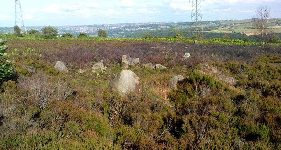
From Harden, go up Moor Edge High Side (terraced row) till you reach the top. Follow the path thru’ the woods on the left side of the stream till you bend back on yourself and go uphill till you reach the moor edge. Keep walking for about 500 yards and keep an eye out to your immediate left. The other route is from the Guide Inn pub: cross the road and go up the dirt-track on the moor-edge till you reach a crossing of the tracks where a footpath takes you straight onto the moor (south). Walk on here, heading to the highest point where the path eventually drops down the slope, SE. As you drop down, watch out for the birch tree, cos the circle’s to be found shortly after that, on your right, hidden in the heather!
Archaeology & History
This aint a bad little site hidden away on the small remains of Harden Moor, but is more of a ‘ring cairn’ than an authentic stone circle (a designation given it by previous archaeologists). An early description of it was by Bradford historian Butler Wood (1905), who also mentioned there being the remains of around 20 small burials nearby. When the great Sidney Jackson (1956; 1959) and his team of devoted Bradford amateurs got round to excavating here, he found “four or five Bronze Age urns” associated with the circle. His measurements of the site found it to be 24 feet across, and although the stones are buried into the peat with none of them reaching higher than 3 feet tall, it’s a quietly impressive little monument this one. About 20 upright stones make up the main part of the ring.
I’ve visited the place often over the last year or so since a section of the heather has been burnt away on the southern edges of the circle. This has made visible a very distinct surrounding raised embankment of packing stones about a yard wide and nearly two-feet high, particularly on the southern and eastern sides of the circle, giving the site a notable similarity in appearance and structure to the Roms Law circle (or Grubstones Ring) on Ilkley Moor a few miles to the north.
There is also the possibility that this ring of stones was the site described by local historian William Keighley (1858) in his brief outline of the antiquities of the region, where he wrote:
“On Harden Moor, about two miles south of Keighley, we meet with an interesting plot of ground where was to be seen in the early days of many aged persons yet living, a cairn or ‘skirt of stones,’* which appears to have given name to the place, now designated Cat or Scat-stones. This was no doubt the grave of some noted but long-forgotten warrior.
* The Cairn was called Skirtstones by the country people in allusion to the custom of carrying a stone in the skirt to add to the Cairn.”
However, a site called the ‘Cat stones’ is to be found on the nearby hill about 500 yards southeast – and this mention of a cairn could be the same one which a Mr Peter Craik (1907) of Keighley mentioned in his brief survey of the said Catstones Ring at the turn of the 20th century. We just can’t be sure at the moment. There are still a number of lost sites, inaccuracies and questions relating to the prehistoric archaeology of Harden Moor (as the case of the megalithic Harden Moor Stone Row illustrates).
Section of the inner ring
The general lack of an accurate archaeological survey of this region is best exemplified by the archaeologist J.J. Keighley’s (1981) remark relating specifically to the Harden Moor Circle, when he erroneously told that, “there are now no remains of the stone circle on this site” — oh wot an indicator that he spent too much time with paperwork! For, as we can see, albeit hidden somewhat by an excessive growth of heather, the ring is in quite good condition.
It would be good to have a more up-to-date set of excavations and investigations here. In the event that much of the heather covering this small moorland is burnt back, more accurate evaluations could be forthcoming. But until then…..
In the vicinity of the denuded ring-cairn and old tumulus of Wortshorne Hill, the Calderdale historian Mr J.A. Heginbottom (1979) described finding this simple cup-marked rock, a hundred yards or so northwest of the old circle. In my ambles here I was unable to locate it. The stone may have been reburied or destroyed. Prehistoric cup-marked carvings are (officially at least) rare things in Lancashire – and usually where you find one, others lurk close by. Do any local folk out there know anything more about this site?
References:
Heginbottom, J.A., The Prehistoric Rock Art of Upper Calderdale and the Surrounding Area, YAS: Leeds 1979.
Paul, Danny and I came here via the Feizor village route, zigzagging about, to and fro, seeing the other old sites in the region; but the easier direct way to get here would be from Settle. Walking through Settle, going out of the top end of town, cross the old bridge and take the country-lane on the right, up northwards towards Stackhouse. A mile along the road (shortly before Stackhouse), a footpath on your left veers up diagonally through a small copse of woods. Go up here and out the other side of the trees, the path turns left and up over the fields. Go up here, and over the third wall along the footpath, you’ll see a large overgrown pile of rocks 30 yards in front of you with a large stone laid roughly in its middle. You’re here!
Archaeology & History
This is an excellent though much neglected prehistoric cairn of some considerable proportions, its rocky mass laying half-covered in deep earth and grasses, yet with still a very large section of it open to the elements. The creature is nearly 30 yards across and some 4 yards high — though it’s hard to say with any certainty, where exactly the natural Earth begins and the cairn starts. But from whichever way you look at this large cairn, walking around the overgrown features, you know it’s a big thing — similar in size and nature to the Great Skirtful of Stones on Burley Moor, and the neolithic cairn on Bradley Moor, near Skipton.
Paul & Danny atop o’ t’ pileBear’s photo, looking SW
On the modern OS-map there are 2 ancient cairns marked close to each other — and our “Apronful of Stones” is the lower one of the two.
In recent years the site was described briefly in Dixon’s (1991) Journey through Brigantia, but there’s been very little written about the place in modern archaeological surveys. The first account I’ve found of the site was written by an anonymous “W.F.” in The Gentleman’s Magazine of 1784. In a detailed lengthy essay, the following words were penned:
“This barrow, or tumulus, stands in an elevated situation, upon a mountain, above the hamlet of Stackhouse, and may be discerned at a great distance…
“The form of this vast mass is circular, or rather orbicular ; the height, by computation on the spot, about 9 or 10 feet. It is composed of an incredible quantity of stones, piled in such a manner as to rest upon each other’s basis, and strengthened by its conic form, it rises upwards in this curious shape. Those stones that form the outside of the work are so small that a soldier could carry them; and since it has been argued that such a monstrous work as this would not be attempted by any nation, but was natural, the largeness of the tumulus may easily be accounted for, since they were annually increased out of reverence…
“This barrow had been opened many years ago, and it is represented in the plate in the state in which it has appeared till lately. Some old people in the neighbourhood remember its being entirely complete, and having a very flat top. It was usual, in finishing these works, to lay a flat stone at the top. The people that opened it left their intention unfinished, only throwing down the lid of the stone coffer, and one or two of the sides; and, meeting with nothing worth digging for, they left it. Upon examining it in this state, before its being entirely disfigured in the last attempt, I found several human bones scattered up and down therein, amongst which I selected the patelae of the knee, the vertebrae of the spine, part of the jaw, and several teeth.
“Round the area is a wall or rampart, of the same materials as the outside, its height from the interior part about 2 feet, irregularly ranged with fissured remnants. In the centre of the cavity or area is the above chest, consisting of several huge stones of vast magnitude and density, fixed firmly into the ground, which supported a lid of equal size, though it is now thrown off the top. In this chest are partitions, for what purpose is not known, unless each space was allotted to its particular relique or body. In the partitions and sides of the coffin is a kind of hole in the edge, with a rude mould. (my italics, PB) Not many weeks ago, the curiosity of some of the neighbourhood was excited to investigate this stupendous work of art, and accordingly labourers were hired, when, upon searching a day (yet not half the work done), a human skeleton was found, in due proportion, and in a fine state of preservation, excepting the skull and one of the limbs, which were moved out of their place by the workmen’s tools. A small circular piece of ivory, and the tusk of an unknown beast, supposed to be of the hog genus, was also found ; but no ashes, urns, coins, or instruments were discovered. ”
Many years later the giant cairn was described briefly in William Howson’s (1850) early survey of the district, when he told that,
“Near a gate on the path, where the descent is commenced to Stackhouse, there’s a cairn of eighty feet in diameter; it has not been completely examined, but human bones are commonly found in it.”
But it was more than a century after “W.F.’s” initial essay before another detailed appraisal of the place was given — and that was after a visit here by the legendary Harry Speight (1892) in the latter half of the 19th century. Along with mentioning a number of other prehistoric tombs upon this ridge, Mr Speight told:
“From Settle Bridge you may take the field-path…or the rustic lane to Stackhouse, and where the road divides just beyond Mr Priestley’s pretty house you wind beneath the wood behind Scale House to a gate and stile on the left. Here ascend the field between two large trees, and at the top go over a stile, whence a path leads up the field a good half-mile to a gate which opens into what our remote Celtic ancestors would have reverentially called the ‘Field of the Dead,’ for within this enclosure are traces and remains of human graves which carry us back to the far dim ages of unwritten history. Following the grassy cart-road a short distance you will see on the left a large circular mound thrown up about 30 feet on the south side, and about 10 feet on the north or higher side. There are other mounds of similar and smaller dimensions within the same area, some of which have been examined, but others do not appear to have been disturbed. Many of the barrows or ‘raises’, have at some time or other been carelessly dug into in the hope of finding valuables, and as doubtless in most cases nothing was found but rude chests or coffins, containing bones, these were tossed aside and no record of them deemed worthy of preservation…
“The largest of these existing raises has happily been described by a writer who signs himself ‘W.F.’ in the ‘Gentleman’s Magazine’ for 1784 and 1785. Although his account fills several pages, it is obviously defective in many particulars. We are told that the circumference of the base of the mound is 210 feet, and that its height is 9 or 10 yards, and that the casing is composed of stones “so small that a soldier could carry them,” while the inside is made up of earth and stones, some of the latter being “much larger than the external coating.” In form it was circular…and the diameter of the summit was 45 feet. The barrow he tells us was opened many years ago, but some old people in the neighbourhood remember it being entirely complete, and having a very flat top.
“…Upon examining it in its former state the writer discovered several human bones scattered about the rock and soil, among them the palletae of the knee, the vertebrae of the spine, part of the jaw and several teeth. In the centre of the mound was a cavity containing a chest composed of four upright stones and a lid 6 feet 9 inches long and 3 feet broad. The chest was in partitions, in the edges of which were a kind of hole with a rude mould. The writer, under date, Settle, Nov 23rd 1784, next informs us that, “not many weeks ago the curiosity of some of the neighbourhood was excited to investigate this stupendous work of art, and accordingly labourers were hired, when upon searching a day (yet not half the work done) a human skeleton was found, in due proportion, and in a fine state of preservation, excepting the skull and one of the limbs, which were moved out of their place by the workmen’s tools. A small circular piece of ivory, and the tusk of an unknown beast, supposed to be of the hog genus, were also found; but no ashes, urns, coins, or instruments were discovered.”
Other important prehistoric monuments can be found on the grassy limestone plain beyond the Apronful: these include the fascinating Sheep Scar Enclosure just 180 yards (165m) to the north; an associated prehistoric cairn (one of several) 57 yards further northeast; and a delightful, though overgrown cairn circle 325 yards NNW. Other Iron Age and Bronze Age remains can be found elsewhere within this arena. Archaeologists could do themselves a big favour by exploring this landscape more efficiently than they’ve done so far as other unrecognized sites exist in this area.
Folklore
Big stone in t’ middle
Harry Speight (1892) told us how the place got its name “from a tradition…that his Satanic Majesty, in haste to complete the bridge bearing his evil name near Kirkby Lonsdale, tripped and his apron-string broke which let drop this immense heap.”
Another tradition narrated again by our anonymous ‘W.F.’ in the Gentleman’s Magazine(1785) said how this giant tomb, “was raised over the body of some of the Danes slain in the general massacre of that nation.” He also told, “Such a conspicuous work must certainly be erected to the manes of some chiefs, though there is no ground to support its tradition.”
References:
Dixon, John & Phillip, Journeys through Brigantia – volume 4: Beyond the Hill of Winds – Walks in Upper Ribblesdale, the Three Peaks & Upper Wharfedale, Aussteiger: Barnoldswick 1991.
Ferrand, William, “Stackhouse, Yorkshire,” in The Gentleman’s Magazine (London 1784).
Howson, William, An Illustrated Guide to the Curiosities of Craven, Wildman: Settle 1850.
Speight, Harry, The Craven and Northwest Yorkshire Highlands, Elliott Stock: London 1892.