Mask Stone, Port of Menteith, Perthshire

Cup-and-Ring Stone:  OS Grid Reference – NN 56107 01712 

Also Known as:

  1. Ballochraggan 12a

Getting Here

Mask Stone, Port of Menteith

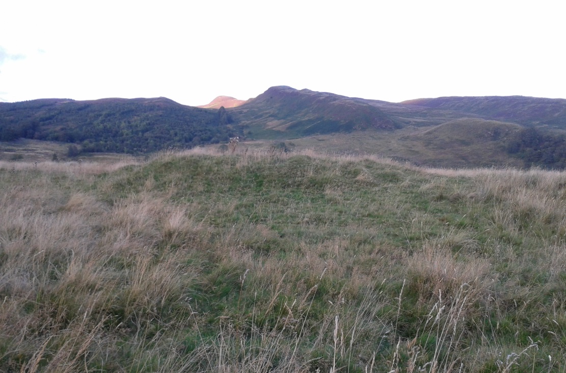
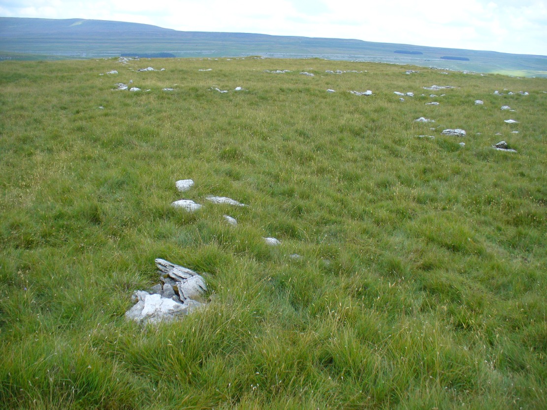
Take the same directions to locate the cup-and-ring stone of Ballochraggan 12.  There are several rocks adjacent.  The one immediately next to it, to the northeast, is the one you’re looking for.  Be gentle and careful if you’re gonna look at it — deadly serious, be very careful indeed!

Archaeology & History

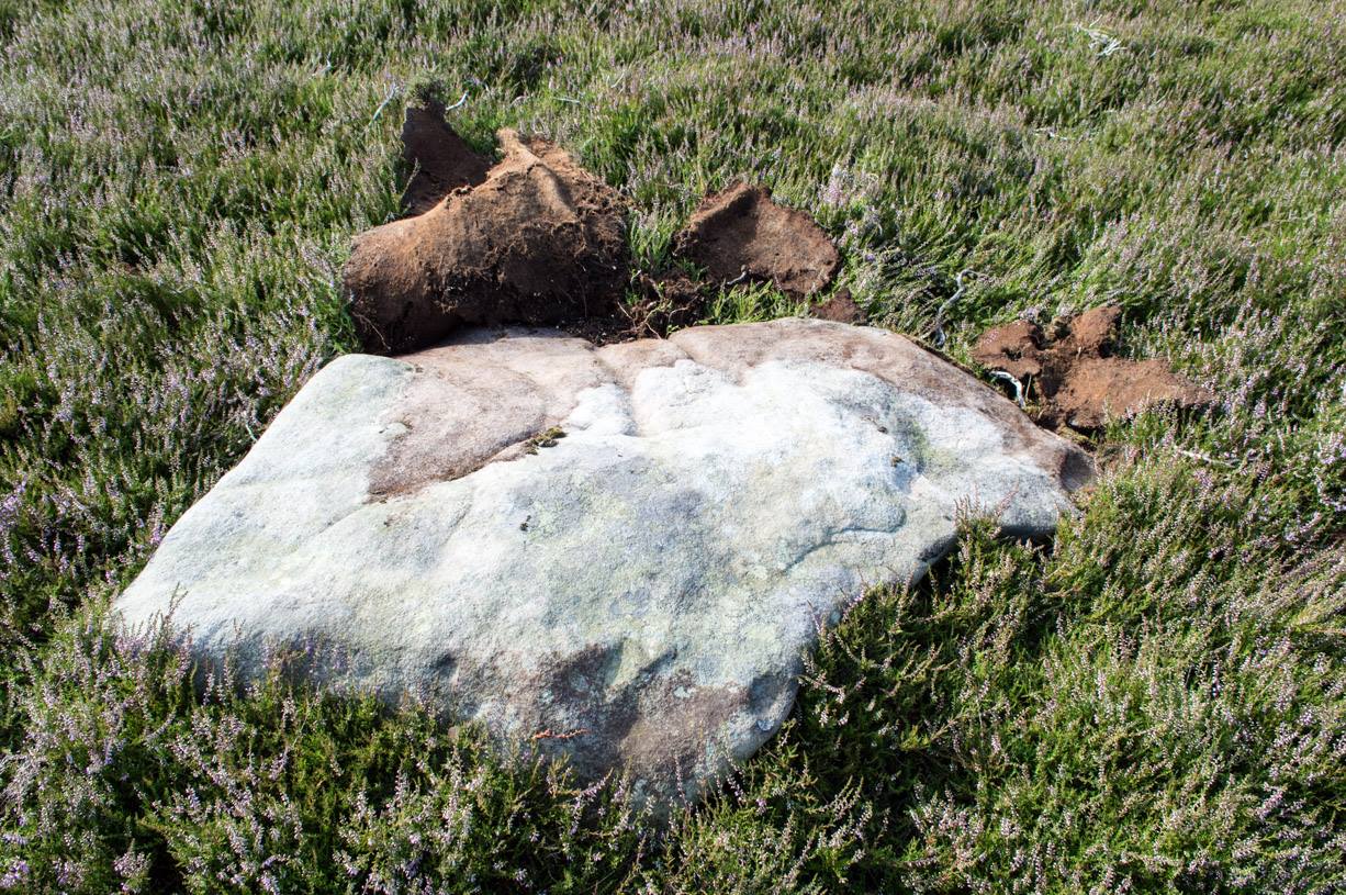
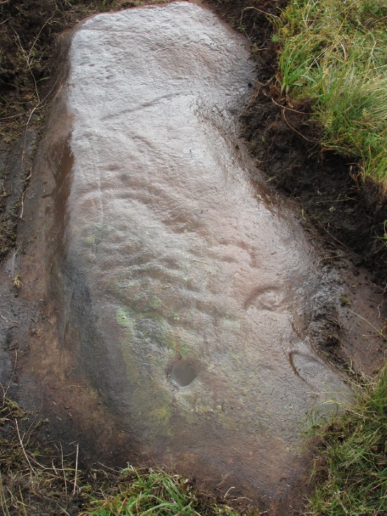
One of the most intriguing and most fascinating of all the prehistoric carvings I’ve yet to discover.  Not that this was all my own work. If it hadn’t been for Paul Hornby, we might have simply walked past it as being little more than a single cup-marked stone—and in this area, single cup-marks tend to be little more than geological in nature.

After we’d looked over several of the registered carvings close by, I did my usual meandering back and forth, stroking stones and seeing if there were any carvings that had been missed by previous surveyors.  And in walking past a small piece of smooth rock, a singular cupmark seemed to stand out.  I walked past it, shouting across to my colleague.

“It looks like we’ve got a single cup-mark here Paul,” I said, “with possible half-ring.”  Thankfully Mr Hornby gave it his better attention.

Mask Stone, with faint 'urn'
Mask Stone, with faint ‘urn’
Close-up of features

The sun was still out and shining across the smooth rock surface, which tends to mean that you’re not seeing any carving on the stone quite as good as it actually is.  Thankfully however, the sun was beginning to get lower and, when this happens, if we wet the rock, any carvings that might be there stand out much better.  And this little fella just seemed to get better and more curious the more attention Paul gave it!

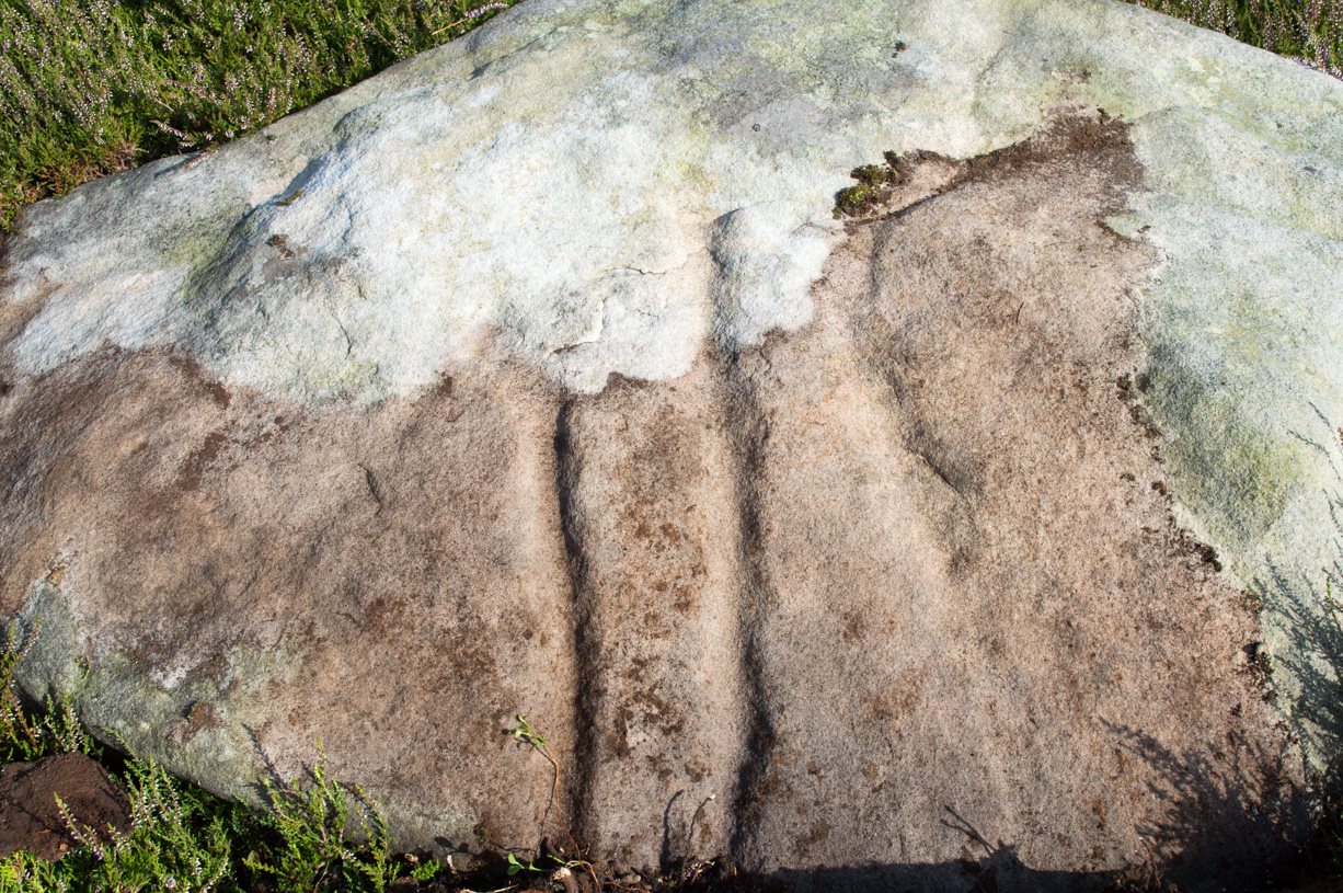
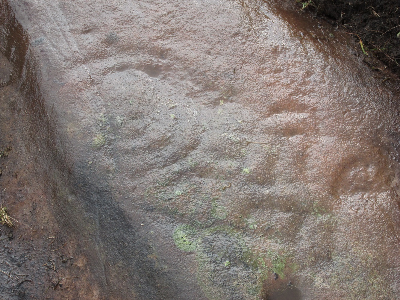
The first thing that became obvious were a series of faint carved lines above the single cup-mark.  Initially these didn’t seem to merit much attention (straight lines on rock are usually more the product of geophysical action than that of humans), but as the rock got wetter, Paul saw something very distinct indeed.

“There’s a face on it!” he exclaimed.  And indeed there was.  A Rorschach response no doubt, but it was still very much like a face.  This looked for all the world akin to the stylised olde English gentry sort of countenance, as in old cartoons.  It was quite ‘distinct’, as such characters themselves insist on being!  Yet around this initial face, more lines seemed to be emerging as the stone gave up more and more of its hidden story.

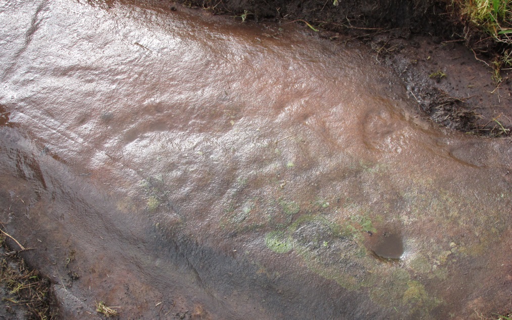
Standing back from an initial investigation, the carving was seen to consist of a triple-ring, but without the traditional ‘cup’ in its centre.  Instead, the centre was marked simply by a small ‘dot’—perhaps, originally, being a small conglomerate hole formed as a result of another tiny harder fragment of stone falling away from its larger mass.  But a ‘dot’ it was.  The other carved ‘lines’ however, immediately below and attached to the triple-ring, gave us something almost unique—and another strong Rorschach response.  As the photos clearly show, we have a distinct second ‘face’ made up of the same lines but in a quite different form.  This ‘face’ has all the attributes we usually associate with pictures of mythical spirits, demons, or a mask—hence the name!

Paul took a series of fine photos, hoping that he could catch the image that our eyes could clearly see.  And thankfully, his digital camera brought the image to life even better than our eyes did!  The ‘mask’ is comprised of carved lozenge forms, akin to the more decorative ones we find at Kilmartin, and more especially around Newgrange, Ireland.  We sat and talked about this: wondering and working out routes that we’d take over mountains and moors, from Ireland, to Kilmartin, then onto Ballochraggan, etching the same designs onto the rocks hereby and attaching similar mythic notions to them: of shamanism and kingship; underworlds and journeys—paradigms lost and certainly misunderstood in the non-polysemia of many modern academics.

Lozenges and rings
Lozenges and rings

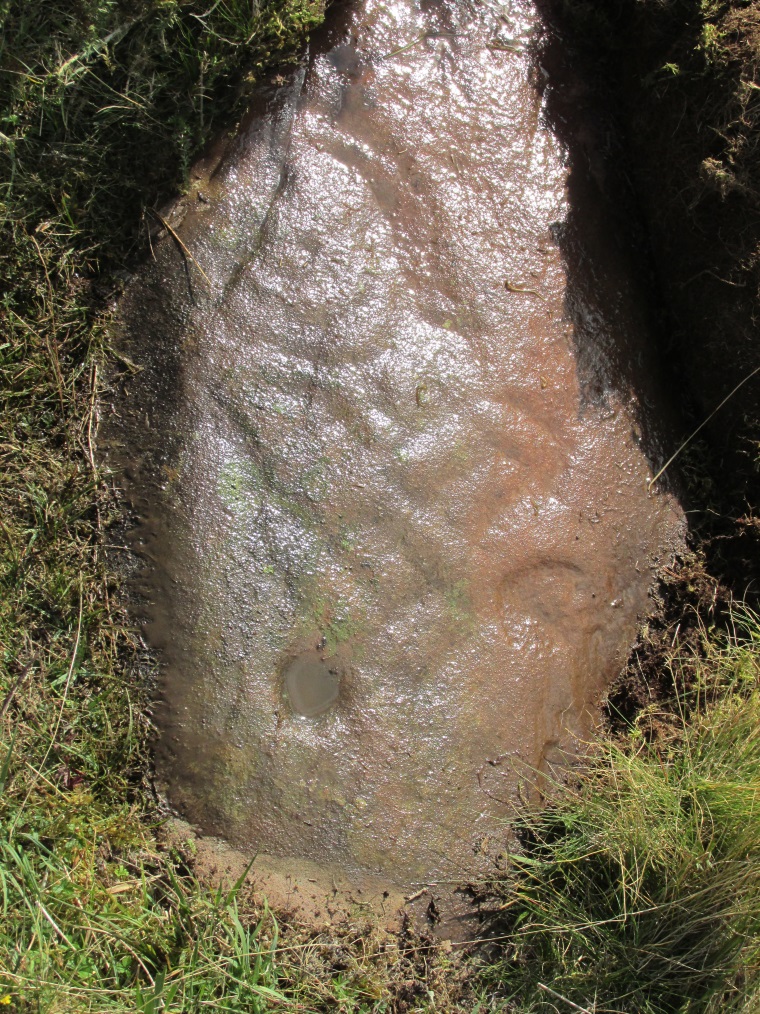
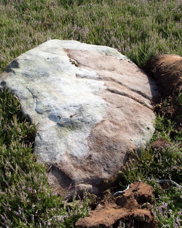
…The stone here was still slightly covered over and, beneath the loose grasses, another feature emerged of another petroglyphic rarity.  At the topmost western side of the  rock a straight line ran across the surface, seemingly marked by the hand of man, with a curious little line almost doubling back on itself for just an inch or so, and then feeling to run down the stone, towards the concentric rings and the face below.  When we stood back and took the photos, this line and its tracer took on a form that I’ve only seen echoed in one of the Netherlargie tombs at Kilmartin, Argyll, 44.4 miles (73km) to the west.  It is very distinct.

Mask Stone04
The beaker, rings & ‘face’

Spuriously ascribed as being ‘axe’ carvings (oh how archaeologists love this Rorschach projection), the Netherlargie North tomb cover-stone in Kilmartin has a series of burial ‘urns’ or beakers carved onto the rock, amidst a scattered collection of cup markings. (Beckensall 2005:73-4; Bradley 1983:92-3; Royal Commission 1971:68-70; Twohig 1972, etc)  Here too at Ballochraggan we find another such symbol, but just a singular example, much larger and more clearly a beaker or urn, as are traditionally found within many old neolithic and Bronze Age tombs; although no tomb is immediately apparent at this Ballochraggan carving.

The entire carving is very faint indeed (you can’t even see it when you’re looking directly at it unless conditions are good) showing that it remained open to the elements for thousands of years.  Other adjacent carvings lack the erosion that we find on this one, even on those which, as archaeologist Lisa Samson said, is “softer sandstone rock than this one”—implying that it’s one of the older carvings in this incredible cluster.

References:

  1. Beckensall, Stan, The Prehistoric Rock Art of Kilmartin, Kilmartin Trust: Kilmartin 2005.
  2. Bradley, Richard, Altering the Earth, Society of Antiquaries Scotland: Edinburgh 1993.
  3. Royal Commission on the Ancient & Historical Monuments of Scotland, Argyll – volume 6: Mid-Argyll and Cowal, HMSO: Edinburgh 1971.
  4. Twohig, Elizabeth Shee, The Megalithic Art of Western Europe, Clarendon: Oxford 1981.

AcknowledgmentsHuge thanks again to Mr Paul Hornby for his considerable help with this site, and for use of his photos.

 © Paul Bennett, The Northern Antiquarian


Ballochraggan 05, Port of Menteith, Perthshire

Cup-Marked Stone:  OS Grid Reference – NN 56044 01549

The Ballochraggan 5 stone

Also Known as:

  1. Ballochraggan 42 (Brouwer)
  2. Canmore ID 78355
  3. Menteith 5 (van Hoek)

Getting Here

Take the same directions as if you’re visiting the Ballochraggan 12 carving, or nearby standing stone.  Literally 10 yards above the leaning monolith, you’ll see what looks like a glacial rock drop ahead of you (though it’s actually volcanic).  That’s the stone you want!

Archaeology & History

A site that was first described in Maarten von Hoek’s (1989) survey of the area, where he told this carving to be “a loose boulder (that) bears 14 cups, some possibly natural.”  There is very little doubt about it—many of the ‘cups’ on this stone are indeed natural, caused directly by the erosion and subsequent falling of conglomerate rock nodules coming away from the larger rock mass, leaving holes in it that look like cup-marks, but are blatantly natural in origin.

Close-up of the cups - natural or man-made?
Close-up of the cups – natural or man-made?

When Paul Hornby and I visited the site on August 28, 2014, we looked briefly at the stone and then walked on by—but we took some photos, “just in case the archaeo’s have this listed as a monument, ” I said.  And they do!  Several of the ‘cups’ shown in the images here might be man-made.  Might….  It’s difficult to say for sure (are there any geologists in the house?)  Of course, if the faint half-ring below one of these large ‘cups’ turns out to be legitimate, we’ve got a definite here.  But even that looks a bit dodgy!

Despite these marks possibly being geophysical, we must not forget, nor rule out, that this rock had some importance to the neolithic or Bronze Age people who frequented this region.  Natural marks on rock would be emulated by humans sometimes, or seen as elements of spirit in the stone itself—as found all over the world.  A standing stone is only yards away, and we have highly impressive multiple cup-and-ring stones very close by.  The natural ‘cups’ on this and other adjacent rocks may have catalysed the petroglyphs themselves.

Check it out when you visit the other, much more impressive multiple-ringed carvings hereby; but also watch out for the many conglomerate rocks still scattering this hill—some with the softer rounded nodules of rock fallen, leaving cups, and others still in place in quite a few of the stones, awaiting their own geological timing to leave more cup-marks ready for some folk to misread. (I did it misself in younger years!)

References:

  1. Brouwer, Jan & van Veen, Gus, Rock Art in the Menteith Hills, BRAC 2009.
  2. van Hoek, M.A.M.,”Prehistoric Rock Art of Menteith, Central Scotland,” in Forth Naturalist & Historian, volume 15, 1992.

© Paul Bennett, The Northern Antiquarian


Nether Glenny 02, Port of Menteith, Perthshire

Cairn:  OS Grid Reference – NN 5644 0202

Also Known as:

  1. Canmore ID 87382

Getting Here

Nether Glenny 2 tomb, looking east

Follow the same directions as if you’re visiting the nearby Nether Glenny 1 cairn; but look into the field immediately north (through the gate on the other side of the fence) about 100 yards away and you’ll see the telling bump rising out of the grasses.

Archaeology & History

Another burial mound of roughly the same size and form as its companion 100 yards to the south, but this one appears to be more intact than its close neighbour.  The top centre of the overgrown cairn seems to have been robbed sometime in the past—perhaps for use in the nearby walling; perhaps by treasure-seekers. We will probably never really know.

Nether Glenny 2 & its close neighbour

Although much overgrown in grasses (with species of shamanic fungi surrounding), the roughly circular tomb is between 3-4 feet high, roughly flat-topped, and measures 12 yards north-south, by 15 yards east-west.  There is no immediate evidence of the internal tomb and it has yet to be satisfactorily excavated.  A small outcrop of stones about 30 yards to the north possesses a highly impressive detailed multi-ringed neolithic petroglyph.

References:

  1. Bailey, G.B., ‘Nether Glenny (Port of Menteith parish)’, in Discovery & Excavation Scotland, 1987.

© Paul Bennett, The Northern Antiquarian


Ballochraggan, Port of Menteith, Perthshire

Standing Stone:  OS Grid Reference – NN 5605 0154

Getting Here

Ballochraggan Stone, looking NE

Take the same directions as if you’re visiting any of the upper Ballochraggan petroglyphs, but 100 yards before the carvings, out in the open on the grasslands, below the reach of the forest, you’ll see the leaning stone if you wander about.  You can’t really miss it!

Archaeology & History

Not included in any of the Canmore, Royal Commission or Ordnance Survey records, this standing stone appears to have eluded official records until now.  Found close to the petroglyph-rich arena of the Ballochraggan complex, with attendant tombs to the east, there is the possibility that this large leaning stone was itself, once, a part of a long-gone cairn, as Paul Hornby suggested.  The small cluster of stones around its base certainly adds to that idea (similar to the incredible Dunruchan cluster, more than 17 miles (28km) northeast).

Ballochraggan Stone, looking west
Looking east-ish!
Looking east-ish!

The stone leans at a considerable angle from a previously upright position.  When standing it would have been nearly five-feet tall and measures nearly as wide.  The stone is roughly triangular in shape, above ground.  What appear to be two faint cup marks on its topmost surface are very probably due to conglomerate rock erosion and not the handiwork of humans.

© Paul Bennett, The Northern Antiquarian


Nether Glenny, Port of Menteith, Perthshire

Cairn:  OS Grid Reference – NN 56470 01923

Also Known as:

  1. Canmore ID 24058

Getting Here

Nether Glenny cairn, looking south

Along the A81 road from Port of Menteith to Aberfoyle, watch out for the small road in the trees running at an angle sharply uphill, nearly opposite Portend, up to Coldon and higher. Keep going, bearing right at Mondowie, then stopping at the dirt-track 100 yards or so further up. Walk up the track, thru the gate, and another 100 yards or so higher up, go thru the gate on your left. Walk up the field alongside the fence until you’re on the level and you’ll see a large rounded mound about 75 yards in the same field to your left.

Archaeology & History

This little known prehistoric tomb sits within a landscape rich in very impressive neolithic and Bronze Age petroglyphs and probably had some relationship with one or more of the carvings in aeons past.  It is one of several tombs in the area.

Rainbow across the tomb

The site was only recently rediscovered in the 1980s, following an archaeological survey of the area before the forestry plantation was done.  Measuring about 20 yards across and about five feet high, the large mound consists of the traditional mass of hundreds, if not thousands of stones.  It seems that a ring of small uprights encircled and defined the edge of the cairn, although this element is only visible on its eastern side.  Its northern mass and edges have been dug into and ruined at some point in the past, leaving a mass of rubble visible beneath the encroaching grasses.  The tomb has not be adequately excavated, so we do not know whether it was built at the same time of the surrounding petroglyphs.  It must be noted (again) that the incidence of tombs and cup-and-ring stones is not infrequent.

The grassland plain where we stand here—with another tomb of very similar form about 100 yards to the north—reminded me somewhat of the Baildon Moor complex in Yorkshire, where rock art and burials are found side by side.

References:

  1. Bailey, G.B., ‘Nether Glenny (Port of Menteith parish)’, in Discovery & Excavation Scotland, 1987.

© Paul Bennett, The Northern Antiquarian


Ballochraggan 01, Port of Mentieth, Perthshire

Cup-Marked Stone:  OS Grid Reference – NN 55900 01005

Also Known as:

  1. Canmore ID 78352

Getting Here

Park by the entrance to Ballochraggan, which is set back off the A81 between Aberfoyle and Port of Mentieth.  Walk up the track, and just before you reach the cottage, notice the large boulder on your left, about 50 yards away. That’s it.

Archaeology & History

The Ballochraggan 1 Stone

This large dolmen-capstone-like boulder in front of the old cottage, was reported by Maarten von Hoek (1989) to possess about 10 faint cup-markings, with a large one near the centre of its upper surface. When Paul Hornby and I visited the site yesterday, several ‘cups’ were visible, but these were purely geological in nature; and even the large cup in the middle seemed somewhat dubious.  The markings are the product of conglomerate rock, where smaller softer types of stone that are embedded in the boulder fall away, leaving cupmark-like indentations and other hollows. There are a lot of conglomerate rocks in these hills and it is essential that all students make themselves aware of the difference between the geological ‘cups’ and those forged by humans.  In many cases this can be difficult, so apply the rule: if in doubt, kick it out—and err on the side of caution.

Some carvings in this region (and elsewhere in the country) possess conglomerate marks that have been enhanced and possess additional rings and carved lines.  On this particular stone, such marks do not seem to exist.  A dodgy example indeed…..

References:

  1. von Hoek, Maarten, ‘Menteith (Port of Menteith parish): Rock Art Sites’, in Discovery & Excavation Scotland, 1989.

Acknowledgements Huge appreciation to Paul Hornby for his photo and assessments.

© Paul Bennett, The Northern Antiquarian


Ballochraggan 12, Port of Mentieth, Perthshire

Cup-and-Ring Stone:  OS Grid Reference – NN 56106 01711

Also Known as:

  1. Ballochraggan 8.04
  2. Canmore ID 78307
  3. Mentieth 9
  4. Mentieth 44

Getting Here

Ballochraggan12 cup-and-ring

Takes some finding this one!  We parked up by the entrance to Ballochraggan on the A81 between Aberfoyle and Port of Mentieth.  Walk up the track, then up the burnside past the house. Keep to its right-side and head uphill towards the very top of the forestry edge, staying in the grasslands.  As you near the very top NE corner of the grassland boscage (NOT into the forest), about 100 yards before it, zigzag about through the gorse and keep your eyes peeled.  It’s there!

Archaeology & History

This is a small, flat, smooth piece of stone with a simple carving clearly visible, in a region replete with highly impressive multiple-ringed petroglyphs.  Very little has been said of this design and even the Canmore lads tell us only that the carving “includes one cup and ring marking and two cups within an oval ring.”  And that’s that!  However, other faint lines are evident on the surface of the stone, with the single cup-and-ring appearing to have another partial second-ring encircling a section of it.  Outlying this are very shallow worn lines that seem to bear the hallmarks of human interference, but they were difficult to see with any certainty and our camera didn’t pick up additional elements with any real clarity.  What seemed to be another cup-and-half-ring (not visible in the photos) was just beneath the edge of the grass where the rock fell back into the Earth.

Ballochraggan12, under cloud

The most catching element of the design is the very obvious ‘eye’ symbol peering up at us as we look down.  Whether this symbol was deliberate or not,  we can be sure that the old archaeologist O.G.S. Crawford (1957) would have loved it and added it to his old dreams of eye goddesses!

Other carvings nearby will blow your head off!  The recently discovered Mask Stone, right next to this Ballochraggan 12 carving, being just a taster of the things to come.

References:

  1. Brouwer, Jan & van Veen, Gus, Rock Art in the Menteith Hills, BRAC 2009.
  2. Crawford, O.G.S., The Eye Goddess, Phoenix House: London 1957.
  3. Naddair, Kaledon, et al, ‘‘Menteith (Port of Menteith Parish): Rock Ccarvings’’, in Discovery & Excavation Scotland, 19, 1992.
  4. Royal Commission on the Ancient and Historical Monuments of Scotland, The archaeological sites and monuments of Stirling District, Central Region, HMSO: Edinburgh 1979.

Acknowledgements Huge appreciation to Paul Hornby for use of his photos.  Cheers mate!

© Paul Bennett, The Northern Antiquarian


Trysting Stone, Doune, Perthshire

Standing Stone:  OS Grid Reference – NN 7256 0182

Also Known as:

  1. Canmore ID 24761
  2. Deil’s Head
  3. Devil’s Head
  4. Fairy Stone
  5. Gold Stone

Getting Here

Trysting Stone of Doune

From the old cross in the middle of the village, walk along the A820 Balkerach Street main road (NOT down George Street) until you reach Station Wynd on your right.  Walk up here for 100 yards towards the new housing estate (don’t buy these places – they’re dreadful quality beneath the veneers) and there, on a small grassy rise on the left just before the car park, stands our stone!

Archaeology & History

This little-known monolith on the northern edge of little Doune village, was recently moved a short distance from its original position thanks to another one of those sad Barratt housing estates being built here; but at least it has received protection with the surrounding fence and notice board telling its brief history and folklore (better than being destroyed I s’ppose).

Stone marked on 1866 OS map
Stone on 1866 OS map

Standing less than five feet tall, local lore tells that it has been moved around close to this spot several times in the last couple of centuries.  Although not mentioned in Hutchinson’s (1893) essay on local megaliths, the stone was highlighted on the 1866 Ordnance Survey of Doune, where the non-antiquated lettering showed how it was thought to be Roman in origin, not prehistoric.

Folklore

Trysting Stane, looking NE

The name of the stone comes from it being used as a place where deeds were sworn, with the stone as witness to the words proclaimed by both parties (implying a living presence, or animistic formula of great age).  This activity was continued in the local ‘trysts’ or cattle fairs held a mile away, where buyers swore the sale of cattle at this stone—again with the stone being ‘witness’ to the spoken deals.  It was also used as a counter where gold was exchanged for cattle bought and sold during the Michaelmas and Martinmas Fairs.  Sue Harvey (2006) told that this standing stone,

“was called the Devil’s Head and was used during past Doune fairs to count gold on when cattle were being bought and sold.”

In local newspaper accounts from the 1950s, local historian Moray S. Mackay (1984) told how the children of the village used to gather round the stone, holding hands, and sing,

Olie Olie, peep, peep, peep,
Here’s the man with the cloven feet,
Here’s his head, but where’s his feet?
Olie Olie, peep, peep, peep.

Notice board telling its tale...
Notice board telling its tale…
Looking at the stone on its rise

This implies the stone once possessed a myth relating to a petrified ancestral deity of animistic (pre-christian) origin, but as yet we have found no additional information allowing us a confirmation of this probability.  A correlate of this theme—i.e., of the stone being the head of a deity—is found in West Yorkshire (amongst many other places), where one of the little known Cuckoo Stones was once known to be a local giant until a hero-figure appeared and cut off his head, leaving only his body which was then turned to stone.  Mircea Eliade (1958; 1963) cites examples of animistic religious rites and events explaining this early petrification formula via creation myths, etc. (we find very clear evidences of animistic worldviews and practices still prevailing in the mountains just a few miles north and west, still enacted by local people)

Folklore also alleged that the stone was Roman in nature, but neither archaeology nor the architectural form of the stone implies this.  Roman stones were cut and dressed—unlike the traditional looking Bronze Age, rough, uncut fella standing here.

References:

  1. Eliade, Mircea, Patterns in Comparative Religion, Sheed & Ward: London 1958.
  2. Eliade, Mircea, Myth and Reality, Harper & Row: San Francisco 1963.
  3. Harvey, Sue, Doune and Deanston, Kilmadock Development Centre 2006.
  4. Hutchinson, A.F., “The Standing Stones of Stirling District,” in The Stirling Antiquary, volume 1, 1893.
  5. Mackay, Moray S., Doune – Historical Notes, Forth Naturalist: Stirling 1984.

© Paul Bennett, The Northern Antiquarian


Douky Bottom, Arncliffe, North Yorkshire

Settlement:  OS Grid Reference – SD 95203 69067

Getting Here

Aerial view of settlement

Go up the B6160 road, heading for Kilnsey Crag.  A few hundred yards past the famous crags, take the little road to Arncliffe.  About a mile up, where you reach the second building on the left-side of the road, walk up behind here, up the steep fields and towards the craggy heights above.  Keep right uphill till you see the cluster of cairns on the peak above; but before reaching them, walk over the rocky landscape to your left (southeast) and you’ll eventually see an excess of straight walling a coupla hundred yards away. That’s it!

Archaeology & History

A bittova climb to get here – but well worth it in the end.  On a spur of land amidst the outstanding limestone plateaux less than a mile south of Arncliffe village, rising near the silent ghostly cairns upon Knotts ridge above it, we come across an extensive prehistoric settlement complex.  It is one of many in this upland region.

Looking south at the settlement
Knott cairns above the settlement

Poorly described (if at all) by official archaeology websites, this place is big!  All that we can see today at ground level are lines of very extensive lines of enclosure walling, between one and three feet high, intersecting each other and forming very large rectangles growing further and further out from each other towards the western scree.  Much of the walled structures are in good condition if they are prehistoric, as presumed by archaeologists; but it seems obvious that the site was in continuous use by local people for domestic and agricultural purposes all through medieval and later periods.

One of the settlement hut circles
Raised lines of ancient walling

The longest stretch of visible walling runs from northeast to southwest and measures 175 yards long (160m), with several stretches of parallel walling splitting the settlement into different sections of large enclosures all attached to each other.  These parallel walls measure a maximum of 54 yards (49.5m) and run northwest to southeast.  The aerial image of the site shows the structures very clearly in some parts.  Others are more vague and some are difficult to see at ground level.  But the settlement as a whole cannot be missed.  Several hut circles have been built inside the main rectangular enclosures, with two others faintly visible on the outer edges.

As far as I’m aware, no excavations have taken place here, so we are still grasping at periodic straws when it comes to dating the place.  When Arthur Raistrick (1929) wrote his article about the associated enclosures like that at Blue Scar, a short distance to the east, he thought them to be Iron Age in origin.  He may well right.  A singular enclosure circle can be found a few hundred yards to the south.

References:

  1. Elgee, Frank & Harriet, The Archaeology of Yorkshire, Methuen: London 1933.
  2. Raistrick, Arthur & Chapman, S.E., ‘The Lynchet Groups of Upper Wharfedale, Yorkshire,’ in Antiquity, volume 3, 1929.

© Paul Bennett, The Northern Antiquarian


Forty Acres (3), Stelling, Marske, North Yorkshire

Cup-and-Ring Stone:  OS Grid Reference – NZ 0758 0058

Getting Here

Surface of Forty Acres 3 carving
Surface of Forty Acres (3) CnR

From Marske village, take the road west and uphill to the villages of Fremington and Reeth.  At the top of the hill where the fields open up, several hundred yards along on your right, past the field with the track, a footpath sign points you up onto the moor. Go up the field till you hit the wall that goes right to the top of the moor. Where the four walls meet, go straight across and then walk northwards along the line of walling for 2-300 yards, keeping your eyes peeled for a solitary stone on its own, 100 yards west.  You’ll find it.

Archaeology & History

Deep carved line features

A pretty basic petroglyph located within a massive arena of prehistoric sites dating from the neolithic and continuing through the Bronze Age period and beyond.  Found a few hundred yards northwest of the once giant cairn of Cock Howe, this design is characterized mainly by the two large deep channels deliberately cut into the stone that run from the middle of the upper surface down to ground level.  One of them emerges from a single cup-marking, at an angle; whilst the other comes from the edge of a natural crack in the rock.  The channels are wide and flattened. Other faint lines can be discerned too, which may have originally been carved.  We need to explore this design in different lighting conditions to see if there are additional features here.

Looking east-ish
Looking east-ish

An archetypal cup-marking can seen on the vertical edge of the stone and three other faint ones scatter the top.  Another small ‘cup’ is along the southern vertical face of the rock which, when we found it, thought was natural; but a photograph of the stone by James Elkington seems to show a ring surrounding much of the cup-mark.  We need to go back and take another look at the place.

A number of other carvings described in Paul and Barbara Brown’s (2008) survey can be found in the region.

References:

  1. Brown, Paul & Barbara, Prehistoric Rock Art in the Northern Dales, Tempus: Stroud 2008.

© Paul Bennett, The Northern Antiquarian