Cup-Marked Stone (lost): OS Grid Reference – NU 2299 2989
Archaeology & History
Tait’s 1971 sketch of the carving
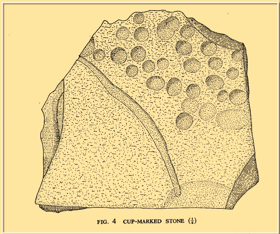
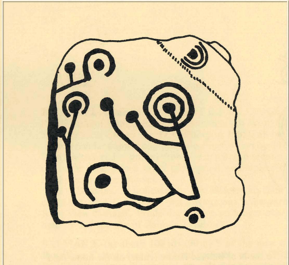
When the Beadnell Caravan Park was being constructed in 1970, in cutting into the Earth the workmen destroyed a couple of prehistoric tombs—but not before one of them (the northernmost one of the two) was thankfully excavated. It was looked at by John Tait (1971), who described the covering cairn as measuring “nineteen feet in diameter and four feet high”. Beneath it, within a cist that had been modified at two very different periods in time, were a large number of human remains that had been deposited over equally extended periods, suggesting it was a place of considerable importance to either one family lineage or the tribal lineage (unless it was just a dumping spot for any old Tom, Dick and Harry!). Outside of the cist itself, but within the rocky mass of the cairn, this cup-marked stone was found (illustrated). It had already been moved by the workmen before Tait came to excavate it, so he was unable to ascertain its precise position in the tomb. Carved into a piece of sandstone were a number of odd-sized cup-marks, smaller than usual. Tait wrote:
“It measures 38cm by 36cm and bears 29 small cup-marks and one slightly sinuous duct leading into what may be part of an earlier and larger cup. It also seems probable that additional cups were added in antiquity, since some are distinctly more shallow than others and, in one instance, two cups impinge upon one another. The stone had been broken in antiquity and may have come from a larger inscribed slab, as is perhaps the case with some other “portable” stones of burials or cairns and other monuments of the second this nature.”
It is thought that the carving was laid back in the ground whence it was found.
References:
Beckensall, Stan, Prehistoric Rock Motifs of Northumberland – volume 1, Abbey Press: Hexham 1991.
Beckensall, Stan, Prehistoric Rock Art in Northumberland, Tempus: Stroud 2001.
Standing Stone (destroyed): OS Grid Reference – SK 5779 0644
Also Known as:
Little John’s Stone
Archaeology & History
Nichols 1804 drawing
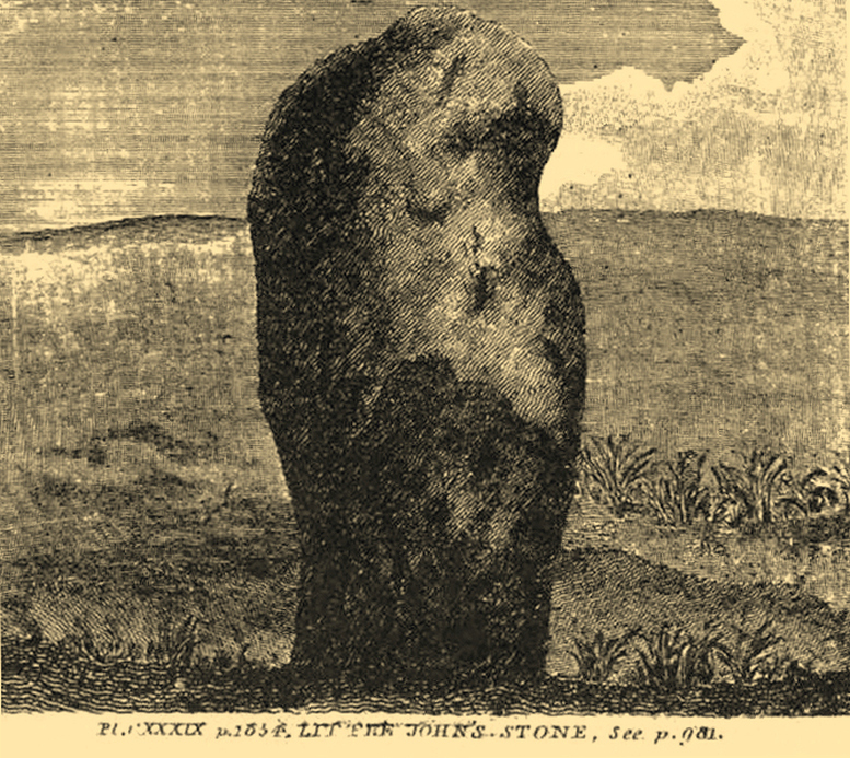
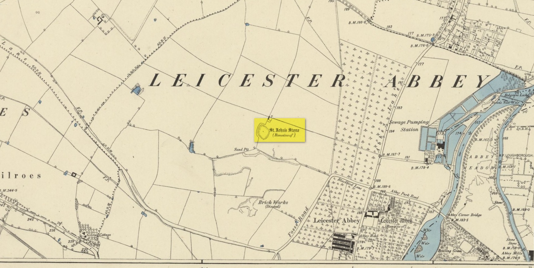
This once impressive megalithic site was first mentioned in 1381, giving its name to the field Johnstone Close. Shown on the early Ordnance Survey maps standing on a raised portion of land in an area north of the modern town centre, not far from the Abbey, its destruction had been a slow one until it finally disappeared about a hundred years ago. One of the early descriptions of it was by John Nichols (1804) in his immense series of works on the county. He called it ‘Little John’s Stone’* and gave us the first known illustration of the monolith (right), telling it to be “7 feet 2 inches high, and 11 feet 3 inches wide”—although he obviously meant circumference and not ‘wide’, as his illustration clearly shows. Although this slight error was perhaps the reason that Historic England proclaimed the stone to have been little more than “a natural feature”—which it clearly wasn’t.
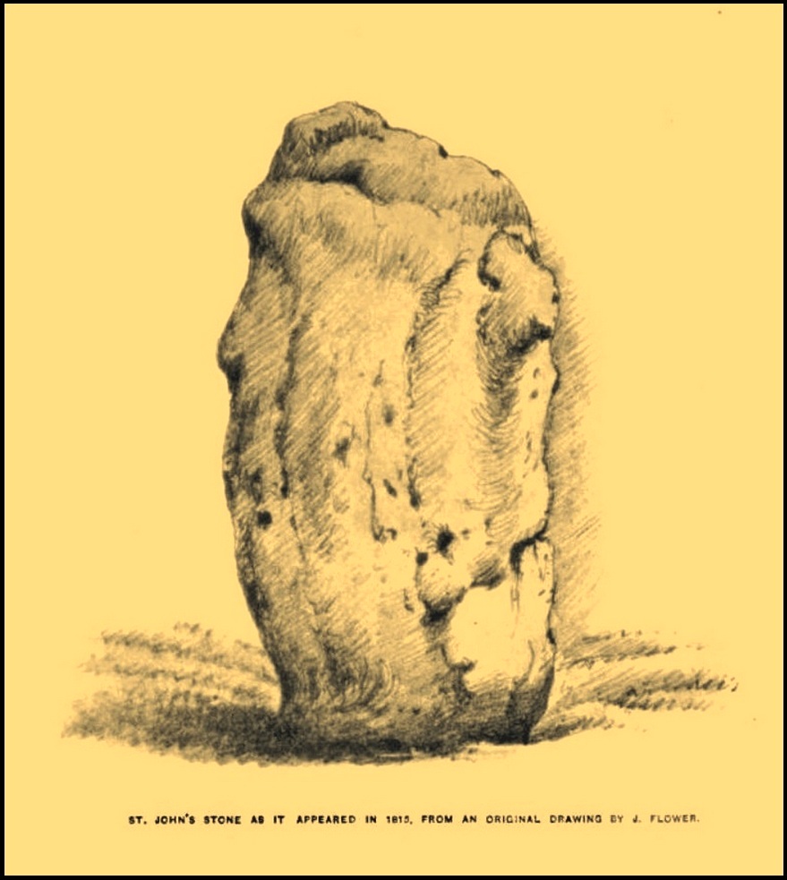
Stone shown on 1885 mapJohn Flower’s 1815 sketch
The stone stood in what Nichols called “a kind of amphitheatre”, and what James Hollings (1855) subsequently called a sloping hollow which, he thought, had “been excavated by the hand of man.” It was located “in a meadow, a little to the west of the Fosse-way,” he said, “not far from the ancient boundary wall of the Abbey of St. Mary de Pratis.” There’s little doubt it was a prehistoric standing stone. Hollings described it as standing erect and told it to be one of those “monolithic erections, or hoar stones, anciently sanctified by the rites of Druidic worship,” comparing it to “similar rude columns” in Cornwall, Scotland and just about everywhere! He also told that it was a place of summer solstice gatherings, being
“in the memory of many living, annually visited about the time of Midsummer by numerous parties from the town in pursuance of a custom of unknown antiquity.”
When James Kelly (1884) wrote about the stone, little was left of it save at ground level. He repeated much of what Hollings had previously written, but had a few notes of his own. One related to the local mayor and MP for Leicester, Mr Richard Harris, dated January 1853, who told him:
“When a boy, he had frequently played on the spot where it was customary for the children to resort to dance round the stone (which he thought was about eight feet high), to climb upon it and to roll down the hill by which the stone is in part, encircled. The children were careful to leave before dark, as it was believed that at midnight the fairies assembled and danced round the stone.”
More than fifty years later when Mrs Johnson (1906) wrote about the place she said that only a small section of the stone still remained, just “a few inches above the earth.” It had been incrementally “broken to pieces down to the surface of the ground and used to mend the road.” (Kelly 1884) Alice Dryden (1911) lamented its gradual demise in size, summarizing:
“At the beginning of the nineteenth century it was about 7 feet high, but by the year 1835 it had become reduced to about 3 feet. In 1874, according to the British Association’s Report, it was about 2 feet high, and it has now completely disappeared.”
Local tradition tells that some small pieces of St John’s Stone were moved to the nearby St. Luke’s church, where bits of it can still be seen. Has anyone found them?
More recent lore has attributed St John’s Stone to have been aligned with the Humber Stone (SK 62416 07095) nearly 3 miles to the east, in a summer solstice line—but it’s nowhere near it! A similar astronomical attempt said that the two stones lined up with the Beltane sunrise: this is a little closer, but it still doesn’t work. The equinox sunrise is closer still, but whether these two stones were even intervisible is questionable.
* this was probably the name it was known by local people who frequented the nearby Robin Hood public house (long gone); its saintly dedication being less important in the minds of Leicester’s indigenous folk.
References:
Cox, Barrie, The Place-Names of Leicestershire – volume 1, EPNS: Nottingham 1998.
Devereux, Paul, “The Forgotten Heart of Albion,” in The Ley Hunter, no.66, 1975.
Dryden, Alice, Memorials of Old Leicestershire, George Allen & Sons: London 1911.
Hollings, James Francis, Roman Leicester, LLPS: Leicester 1855.
Kelly, William, Royal Progresses and Visits to Leicester, Samuel Clarke: Leicester 1884.
Nichols, John, The History and Antiquities of Leicestershire – volume 3: part 2, J. Nichols: London 1804.
Trubshaw, Bob, Standing Stones and Markstones of Leicestershire, Heart of Albion Press 1991.
Acknowledgements:Huge thanks for use of the Ordnance Survey map in this site profile, reproduced with the kind permission of the National Library of Scotland.
Cup-and-Ring Stone (lost): OS Grid Reference – NX 68700 44699
Archaeology & History
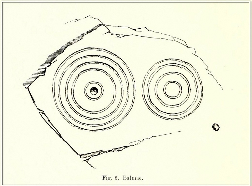
Coles’ 1895 sketch
This impressive-looking carving was rediscovered in the 1880s during one of Fred Coles’ ventures uncovering many of the petroglyphs in this area. It could be found, he said, “some three hundred yards south-east of Balmae House.” When the local historian Malcolm Harper visited Samuel Fletcher who lived in the cottage at Balmae a few years after it had been discovered, he spoke enthusiastically about the carvings and knew much about them, but Harper doesn’t specifically mention whether or not he’d seen this stone (he probably did). Nowadays the carving is covered in thickets of gorse and and, as a result, it hasn’t been seen in many a year. The great Scottish petroglyph hunter Kaledon Naddair may have been one of the last people to visit it.
It’s impressive, as Mr Coles’ (1895) sketch shows, comprising, as he said, of
“two sets of concentric rings, one having four, the other five and a central cup. It is smooth, and slopes to the W. at an angle of 40°. The largest ring is 24 inches in diameter.”
A number of other impressive multiple-ringed carvings exist hereby that have also fallen prey to the cover of gorse. So get some hedge-cutters and decent gardening gloves if you’re gonna look for this one!
Morris, Ronald W.B., “The Cup-and-Ring Marks and Similar Sculptures of South-West Scotland,” in Transactions of the Ancient Monuments Society, volume 14, 1967.
Morris, Ronald W.B., The Prehistoric Rock Art of Galloway and the Isle of Man, Blandford: Poole 1979.
Royal Commission Ancient & Historical Monuments & Constructions of Scotland, Inventory of Monuments and Constructions in Galloway – volume 2: County of the Stewatry of Kirkcudbrightshire , HMSO: Edinburgh 1914.
OK—I’m cheating here, as I’ve not visited this site (bad of me!). The directions given here are from Harper’s 1876 Rambles in this area. He told that the stone “stands about 100 yards to the north of the march dyke betwixt Upper Ervie, now Ken-Ervie and Nether Ervie. There is little to indicate its whereabouts, but the visitor coming from Kenmure Bridge, and leaving the road on the left, opposite Ringour and Bennan farms, on the opposite side of Loch Ken, would come upon it without much trouble by following the march dyke half a mile up.” Basically, along the A713 just over 2 miles north of the bridge at Parton (½ mile before reaching the Galloway Activity Centre), 60 yards from the “Farm Access No Parking” spot, in the trees a long straight line of walling runs uphill. That’d be my route—straight up!
Archaeology & History
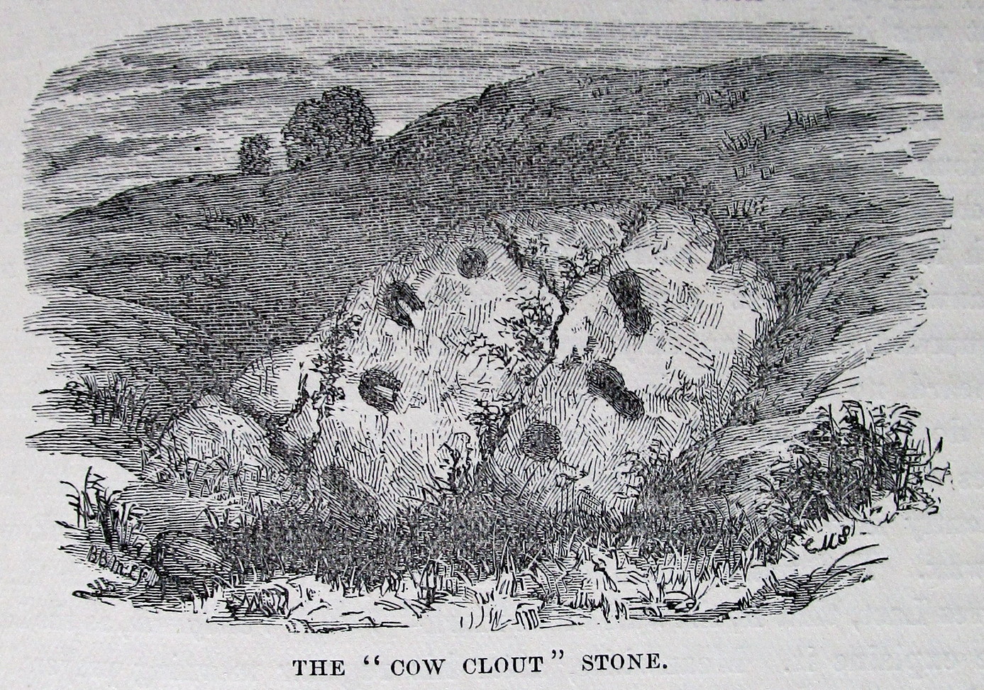
This is a curious entry that I’ve added without visiting the site; but as I might never get to see it I thought it should be displayed in the hope that others might check it out. The earliest literary reference to it is from Crosbie’s (1845) entry in the New Statistical Account, where he implies that the markings on the stone are not of Nature’s handiwork. In Malcolm Harper’s (1876) fine work exploring the history and folklore of this region, he gave us the first illustration of the stone, which looks suspiciously like elements that we find on cup-and-ring stones. Many years later when the Royal Commission (1914) lads followed up on Crosbie’s entry, they thought the markings were probably Nature’s handiwork. They told that:
“It is an irregular mass of outcropping rock about 3 feet in diameter, and bears on its surface certain depressed markings supposed to represent a cow’s foot, a horse-shoe, and impressions which might be made by a man’s foot and knee in the act of kneeling. The markings appear to be natural.”
But it’s the animistic elements and traditions here which are important and which gave the stone its very name…
Folklore
When Rev. W.G. Crosbie (1845) first wrote about this stone, he was narrating the tale told of it by local people, whose traditions were greatly neglected by the majority of writers at that time. Such stories should be preserved at all times, as they tell us more about the psychocosms of pre-industrial cultures. Here,
“On the farm of Arvie, there is a flat stone about three feet in diameter, on which are the marks of what might be supposed a cow’s foot, a horse shoe, the four nails on each side being very distinct, and the impression which might be made by a man’s foot and knee while he was in the act of kneeling, the knot of the garter being quite evident. The tradition connected with this remarkable stone, commonly called the ‘Cow Clout,’ is, that the proprietor, in order to get up arrears of rent, “drave the pun,” or in other words, carried off the hypothecated stock, while a fierce resistance was made by the people, and that over this stone, on which a man had just been praying for relief against his enemies, the cattle passed followed by an officer on horseback, and that it remains as a memorial to posterity of the cruel deed.”
If someone in that neck o’ the woods can find out if the stone’s still there and perhaps send us a photo, or stick it on our Facebook group, that’d be great! 🙂
References:
Coles, Fred, “The Recent Cup and Ring Mark Discoveries in Kirkcudbrightshire”, in Proceedings Dumfriesshire & Galloway Natural History and Antiquarian Society, volume 5, 1888.
Crosbie, W.G., “Parish of Parton,” in New Statistical Account of Scotland – volume 4, William Blackwood: Edinburgh 1845.
Harper, Malcolm M., Rambles in Galloway, Edmonston & Douglas: Edinburgh 1876.
Royal Commission Ancient & Historical Monuments & Constructions of Scotland, Inventory of Monuments and Constructions in Galloway – volume 2: County of the Stewatry of Kirkcudbrightshire , HMSO: Edinburgh 1914.
Stone Circle (destroyed): OS Grid Reference – NX 8657 6668
Archaeology & History
Little is known about this stone circle, which had apparently been destroyed sometime in the first half of the 19th century. The local Rev. J. Gillespie spoke about it with the great Fred Coles (1895), who told that it was “near the manse of Kirkgunzeon.” The site was listed in Burl’s (2000) magnum opus, where he wondered if it might have been a cairn; and interestingly, when the Ordnance Survey lads came here, they spoke with a Mrs J. Moffat, the oldest inhabitant in the area, who told that,
“a circle of stones c.30 ft in diameter with a small mound in the centre stood on flat ground at NX 8657 6668. Over the years successive farmers have removed the larger stones and now only the slight mound, c.4.0 m diam. x 0.3 m high, with several clearance stones on top, survives to mark the site of the stone circle.”
References:
Burl, Aubrey, The Stone Circles of Britain, Ireland and Brittany, Yale University Press 2000.
Coles, Fred, “The Stone Circles of the Stewartry of Kirkcudbright”, in Proceedings Society Antiquaries, Scotland, volume 29, 1895.
Stone Circle (destroyed): OS Grid Reference – NX 681 450
Archaeology & History
In an area that’s littered with prehistoric rock art, this “stone circle” at Knockshinne—listed in Burl’s (2000) magnum opus—is a debatable entry that was described in one of Fred Coles’ (1895) many articles on such matters. When he came here he told how to the west,
“of Balmae House, and near the base of Knockshinnie, four stones in situ, all, I think, granite, and the sites of six others as distinctly observable…. A massive stone lies outside the circle on the south. Diameter 72 feet.”
Subsequent visits to the same spot by the Royal Commission (1914) gave a somewhat different interpretation to that suggested by Coles. They told us that,
“This setting of stones, noted elsewhere as a stone circle, lies on rough pasture some 100 yards below the road passing to the south-west of Knockshinnie, and about ¼ mile west-north-west of Balmae. It consists of four granite blocks, the highest standing about li feet above ground, placed on an arc with a chord of 76 feet and radius at centre of 21 feet. The stones are placed at irregular distances on a sloping bank, so that the lowest stone is at 8 feet lower elevation than the upper one. Other two displaced boulders and a number of smaller stones lie in a heap to the north-west, and the beds of stones which have been removed from the setting are visible. Though the boulders have been placed in position by man’s hand, it is doubtful if they have ever been part of a stone circle, and from their situation on a slope below a plateau it is probable that they represent the line of an old dyke.”
By the 1970s, all that remained here was a line of three stones, but these have subsequently been removed or destroyed. Modern archaeological interpretation goes against Burl (2000) and Coles, suggesting that the stones were more likely part of an ancient dyke.
References:
Burl, Aubrey, The Stone Circles of Britain, Ireland and Brittany, Yale University Press 2000.
Coles, Fred, “The stone circles of the Stewartry of Kirkcudbright”, in Proceedings Society Antiquaries, Scotland, volume 29, 1895.
Royal Commission Ancient & Historical Monuments & Constructions of Scotland, Inventory of Monuments and Constructions in Galloway – volume 2: County of the Stewatry of Kirkcudbrightshire , HMSO: Edinburgh 1914.
Acknowledgements:Huge thanks for use of the Ordnance Survey map in this site profile, reproduced with the kind permission of the National Library of Scotland.
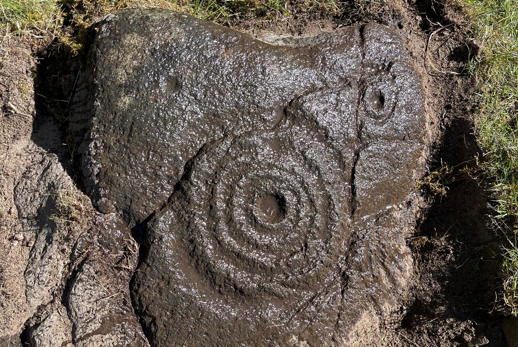
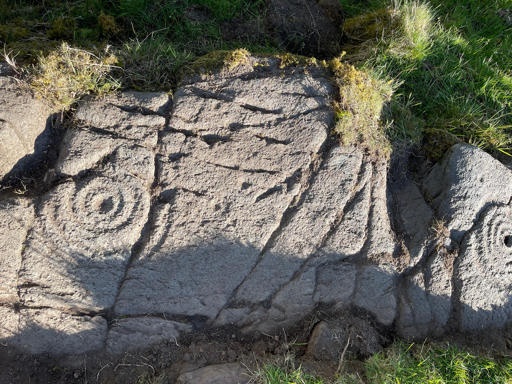
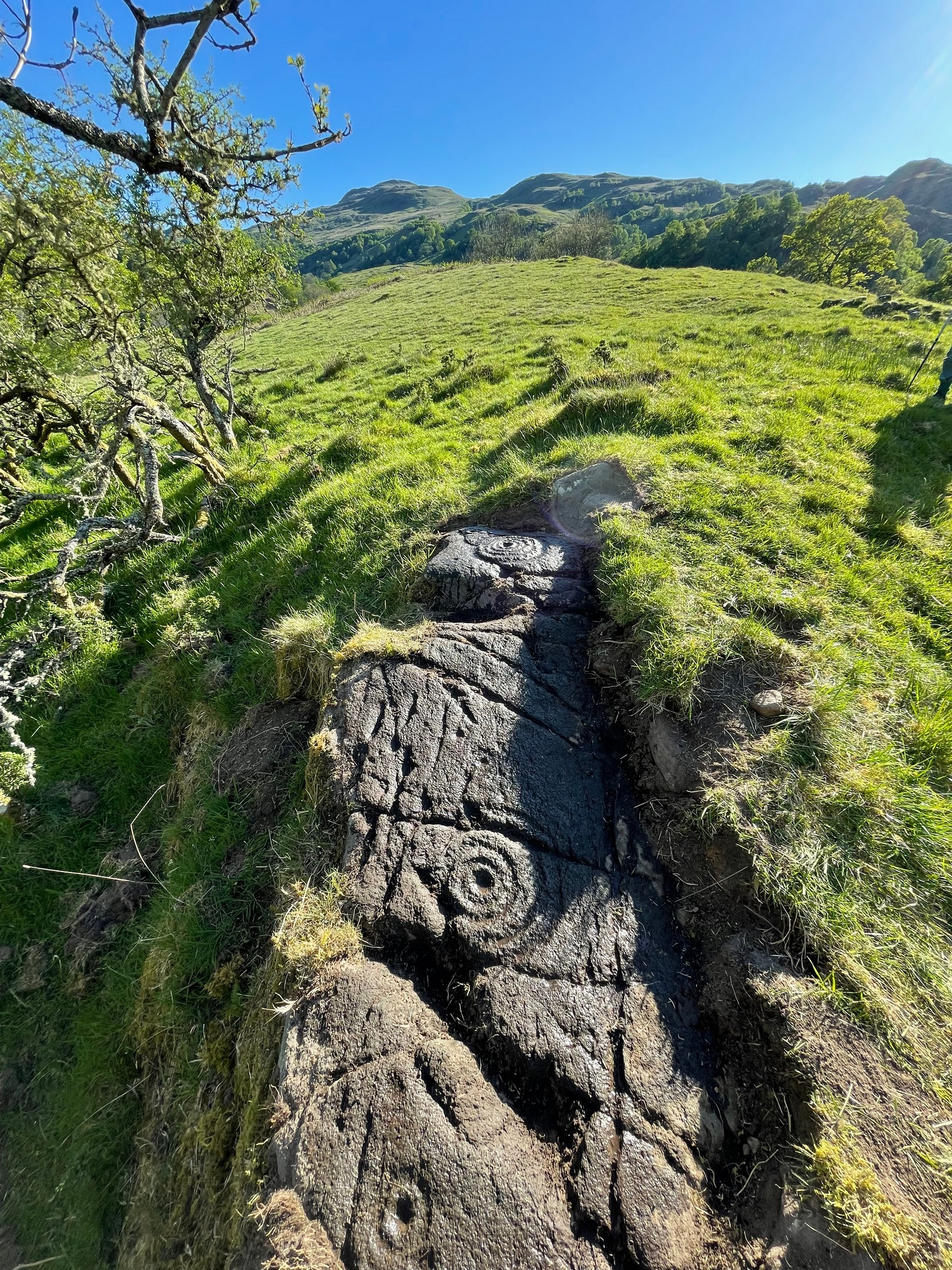
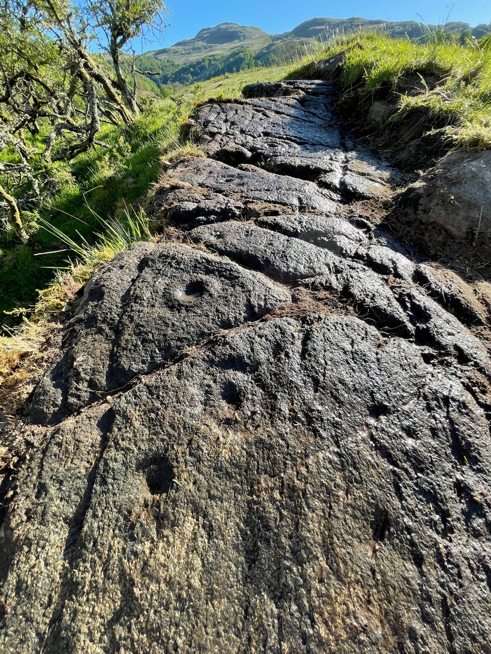
This is a relatively new find that was uncovered in 2019 by members of the Association of Certified Field Archaeologists, on the western edge of a small bowl of blackthorn trees, just past one of the Corrycharmaig East carvings — and it’s a bit of a beauty!
Topmost part of carvingCorrycharmaig (9) stone
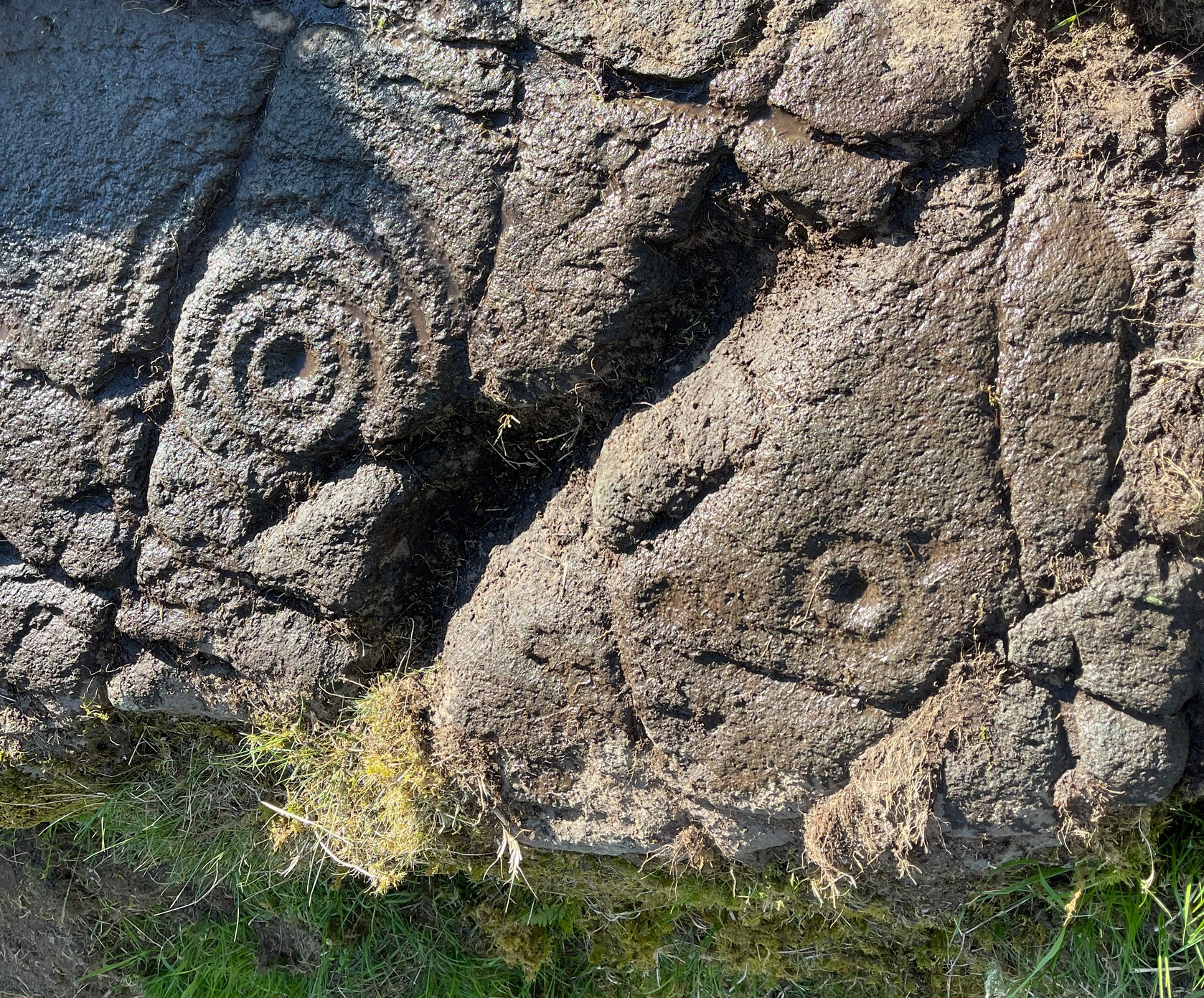
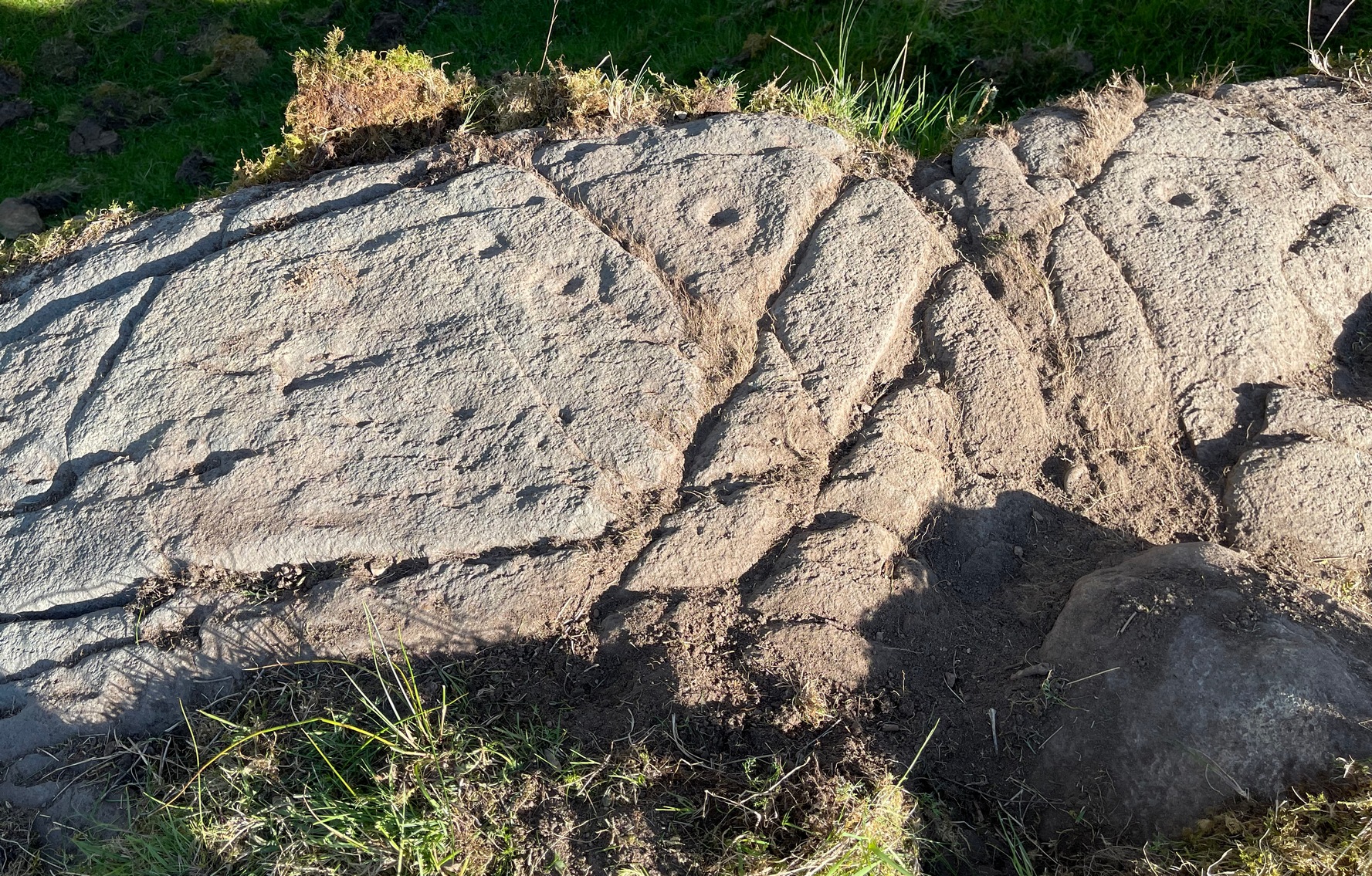
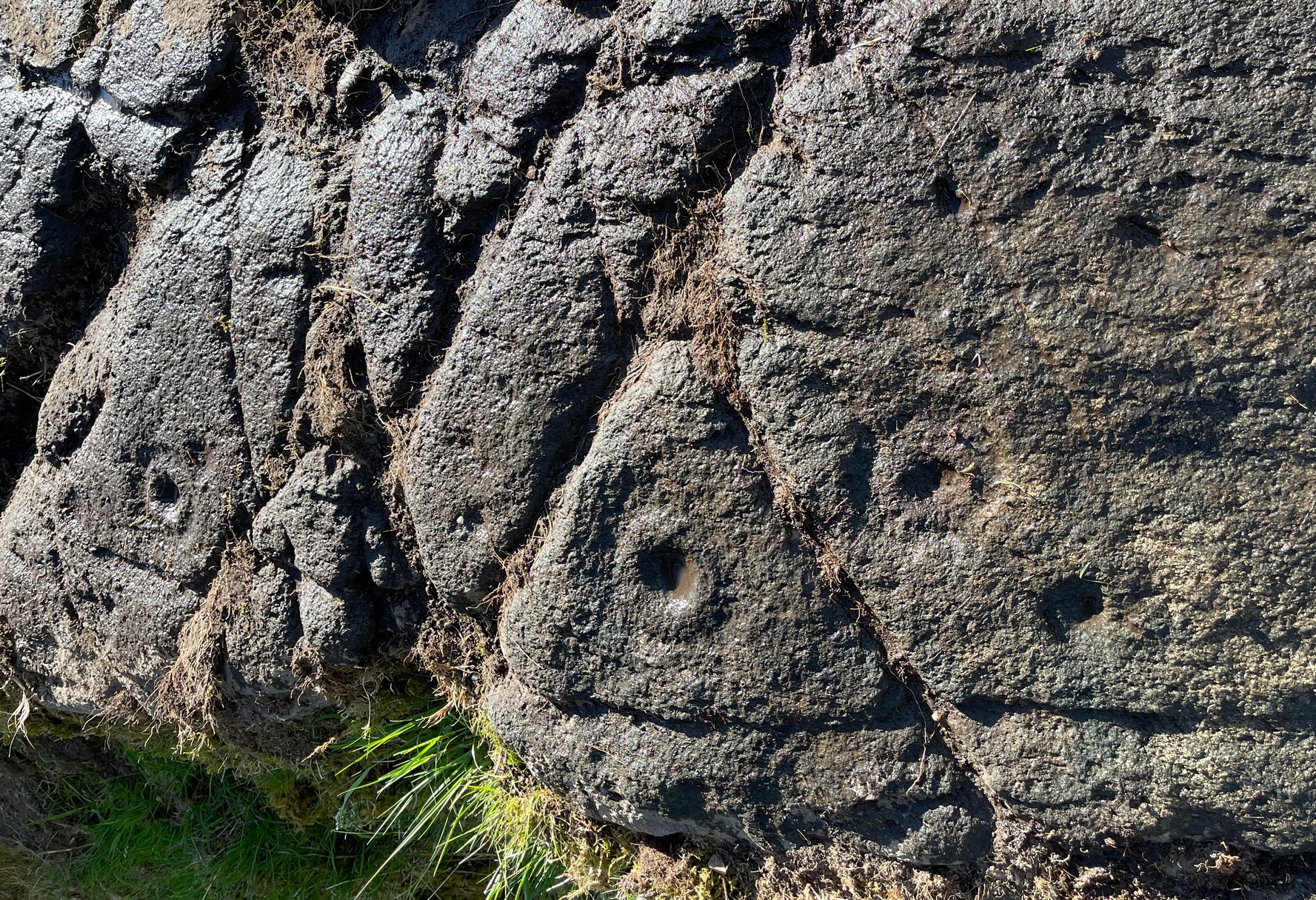
Described, albeit briefly, in the superb survey by Gardiner, King & MacInnes (2024), the carving here has been cut into a sloping straight line of rock along the ridge of a very tiny cliff and consists of cups, single rings and multiple rings. At its crown, so to speak, where the rock surface levels out and is flat, a very well-preserved multiple cup-and-ring greets our senses: a cup-and-four rings to be precise. The outermost edge of the rings cuts into a natural crack that runs to the edge of the stone; and close to where this crack reaches the edge, another standard cup-and-ring rests against it. On this same section you’ll see a single cup which, by the look of it, was intended to have a much wider ring surrounding it—but for some reason it was never executed.
Second multiple-ringerSecond multiple-ring
From the topmost section, the rock then slopes gradually downward and the design is broken by several natural splits in the stone before we reach a single unfinished cup-and-ring and a solitary cup-mark. These occur shortly before we reach a near-duplicate of the multiple-ringer that we’ve just seen on the flat top of the stone. The outer ring of this is broken and the edges of it are intruded (again) by natural cracks in the stone (a not uncommon feature). The erosion level of this and its fellow four-ringed compatriot at the top are much the same, suggesting that the two were executed at around the same time.
Lower-half with cup&ringsClose-up of cup&rings
As we move down the slope of the rock with its veritable scattering of geological splits, the rest of the design consists of several single cup-and-rings—at least three of them—over its lower-half, almost in a gentle arc over the surface. The one closest to the four-rings has a single cup-mark attached to its outer edge and another single one just a few inches away from it. The others don’t seem to have any additional carved features attached to them; although one or two other singular cup-marks can be seen on this, the lowest section of the carving.
Looking to the hillsFrom the bottom up
An interesting feature noted here is the direction that this line of rock points to: a dip between two distinct rocky peaks on the horizon and which is close to the winter solstice sunset. I should point out however, that the relationship between open air petroglyphs and astronomical alignments (in Britain at least) is very debatable. Even alignments from one carving to another are pretty meaningless, despite the attempts of some modern archaeologist to show otherwise. In my younger days when I raced into rock art studies, I threw everything I had to show astronomical and other alignments were involved in these carvings—but it turned out not to be…. Instead, it turns out that some of these seeming ‘alignments’ (and only a few) relate to pathways and ancient routes: pointers, if you like, to the way ahead. Makes sense…
References:
Gardiner, M., King, L. & MacInnes, Dugald, In the Glen of the Dark Goddess, Bell & Bain: Glasgow 2024.
Acknowledgements:Huge thanks for use of the Ordnance Survey map in this site profile, reproduced with the kind permission of the National Library of Scotland.
Cup-and-Ring Stone (lost): OS Grid Reference – NX 529 528
Also Known as:
Bardriston
Archaeology & History
In a region possessed with a good number of cup and ring stones, this one on the lower slopes of Barholm Hill may have once been part of a prehistoric tomb, or cist cover. A fairly decent design had been carved onto a small flat slab of stone which, when uncovered in the 19th century, doesn’t seem to have been in its original position. As the great Fred Coles (1894) told us:
Coles’ 1895 sketch
“The Bardristan slab…was removed from amongst the stones of an old drain in 1889, and, through Mr Kinna’s care, it is now preserved at Bardristan. The evident attempt to square the stone itself; the extreme smallness of the rings ; the direct connection of the grooves, in all cases but one, with cups; and lastly, the vivid sharpness of the whole sculpturing, in which the tool-work is clear much beyond the ordinary, all combine to render this Bardristan slab unusually interesting and valuable.”
Less than twenty years after Coles’ description, the Royal Commission (1914) lads visited the site hoping to make their own assessment, but the carving had already been lost. Referring to Coles’ account, they told how,
“inquiry there failed to elicit information concerning it, and it appears to have been lost. Mr Coles’ illustration…shows in the general intercommunication of the various cups a feature which characterises the stone at Kirkclaugh, about ¼ mile to the south of Bardriston.”
In the subsequent commentaries on this carving by Ron Morris (1967; 1979) and A.E. Truckell (1961), its whereabouts remained a mystery and, to this day, we know not what became of it…
Morris, Ronald W.B., “The Cup-and-Ring Marks and Similar Sculptures of South-West Scotland,” in Transactions of the Ancient Monuments Society, volume 14, 1967.
Morris, Ronald W.B., The Prehistoric Rock Art of Galloway and the Isle of Man, Blandford: Poole 1979.
Royal Commission Ancient & Historical Monuments & Constructions of Scotland, Inventory of Monuments and Constructions in Galloway – volume 2: County of the Stewatry of Kirkcudbrightshire , HMSO: Edinburgh 1914.
Truckell, A.E., “Cup-and-Ring-Marked Slabs in the Cairnholy and Auchinlarie Area,” in Transactions of Galloway & Dumfriesshire Natural History & Antiquarian Society, volume 40, 1961.
Acknowledgements:Huge thanks for use of the Ordnance Survey map in this site profile, reproduced with the kind permission of the National Library of Scotland.
Park up at the singular dusty car-park on the east-side of Askwith Moor Road. If you walk to the sloping eastern edge of the car-park and then go down and over the collapsed fence onto the moorland immediately east, walk in the direction of the Tree of Life Stone to the north-east (be aware that there’s no footpath here and it’s boggy as fuck in places) . Just over halfway towards the carving, nearly 400 yards from where you’ve parked, you’ll begin to see various ruinous piles and scatters of stone. You can’t really miss them!
Archaeology & History
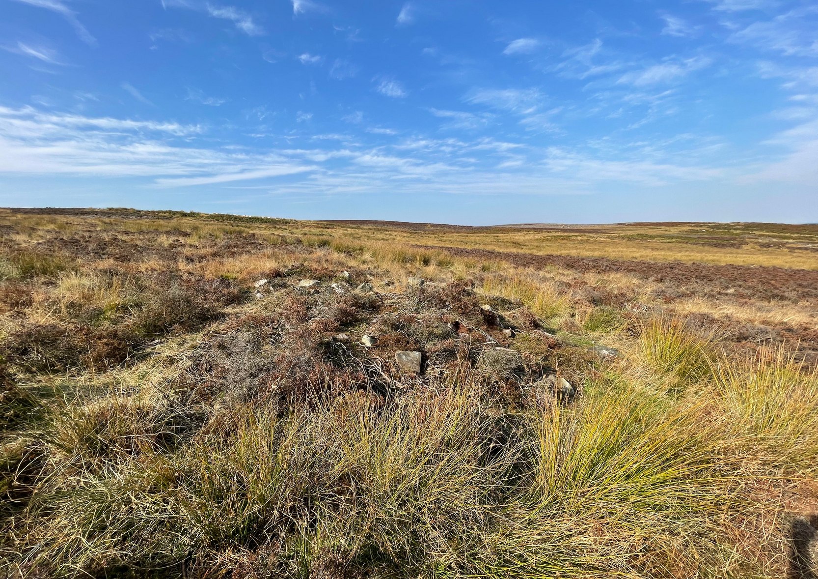
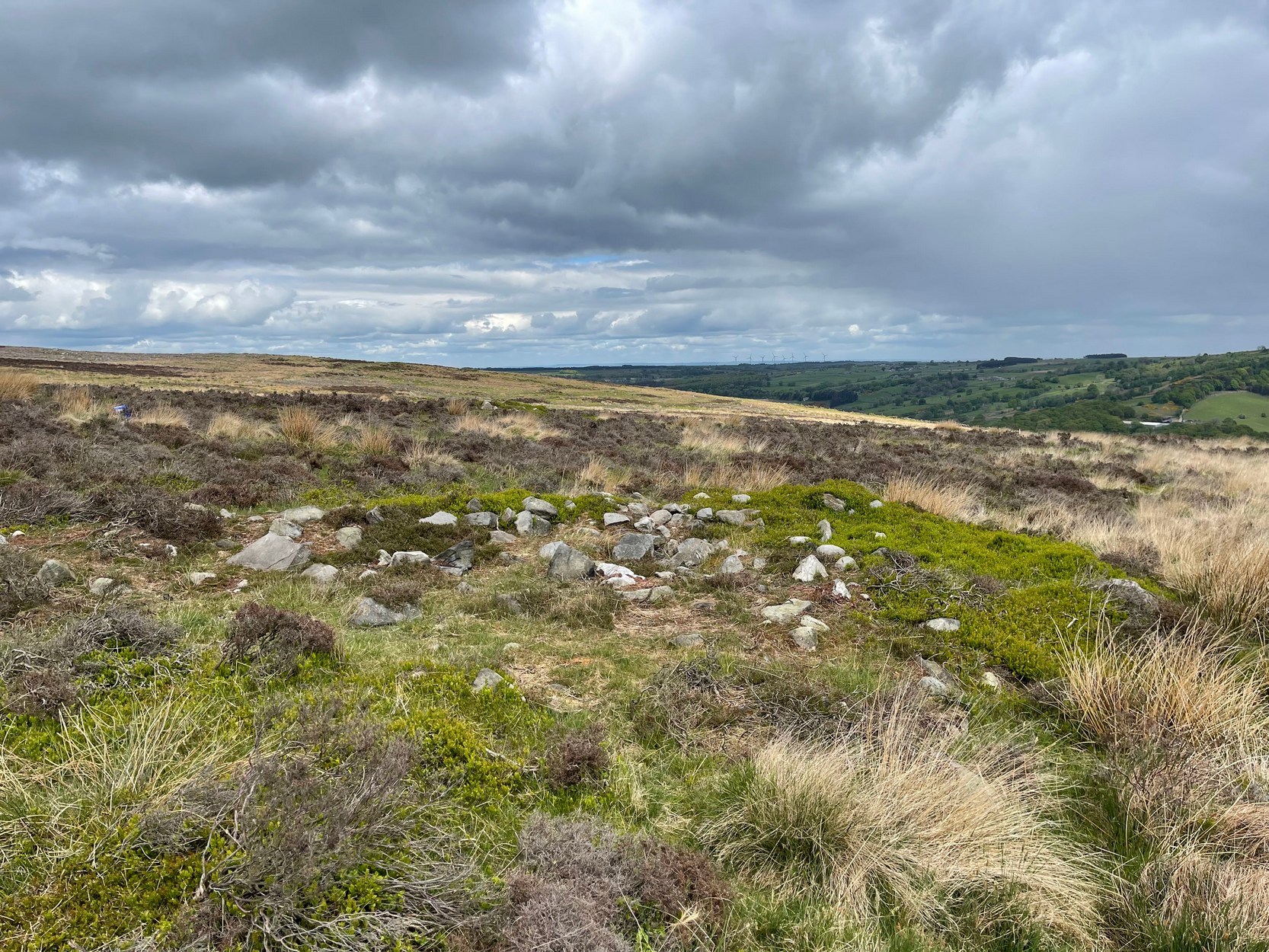
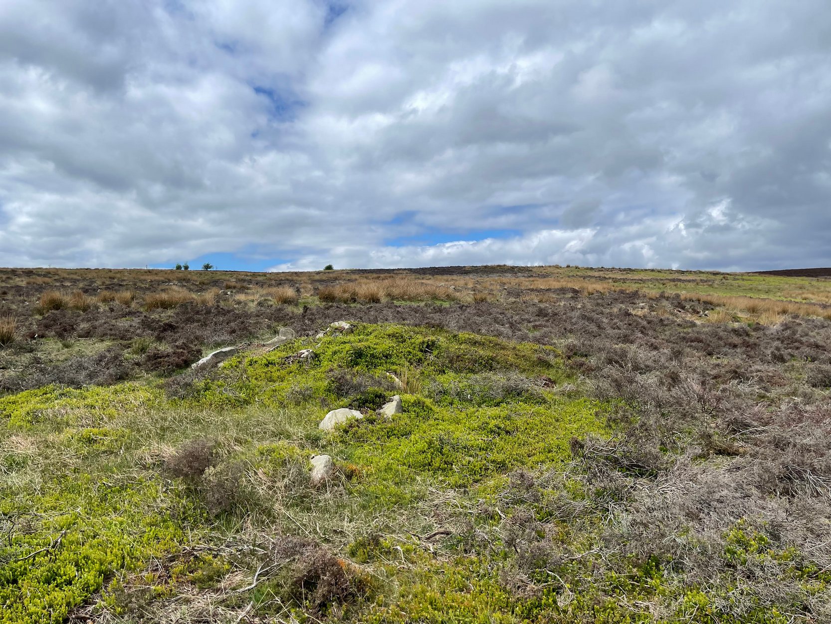
Cairn, looking north
In a region teeming with prehistoric sites, the great Eric Cowling (1937) seems to have been the person who stumbled across this “barrow group”, as he called it, during one of his rock art forays in this neck o’ the woods. Little has been written of them since. Not to be confused with the Snowden Moor cairnfield more than 350 yards to the north, at this place we find at least a dozen quite distinct cairns scattered around the grid-reference cited, most of them much larger in size than the cairns to the north, ranging between five to twelve yards across and up to three feet high. They have all been opened and robbed, with considerable disturbance on the largest of the ‘barrows’. We know not who may have done this, but there’s been a history of quarrying close by and it may have been some of the workmen who did the damage, knowingly or otherwise.
Large scatter of cairn-spoilCairn covered in bilberries!
As far as I’m aware, no burial or funerary remains have been found here—but there’s been negligible archaeological attention given to any of the sites on this moorland, meaning that we can draw no real conclusions about the nature of the cairns. They seem to be far too large to be clearance cairns; and the proximity of large scale prehistoric settlements and rock art all round here would strongly suggest they possessed a funerary nature. Several impressive petroglyphs exist right at the edge of this group, literally yards away from them. Check them all out out the next time you see the Tree of Life stone…
References:
Cowling, Eric T., ‘Cup and Ring Markings to the North of Otley,’ in Yorkshire Archaeological Journal, volume 33 (part 131), 1937.
Cowling, Eric T., Rombald’s Way: A Prehistory of Mid-Wharfedale, William Walker: Otley 1946.
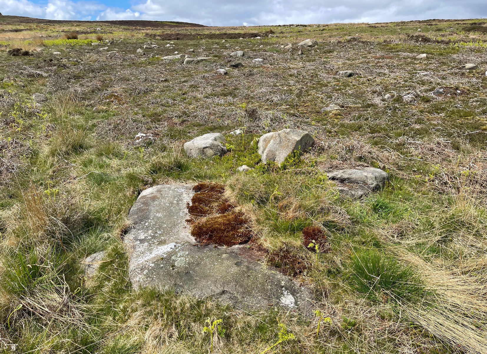
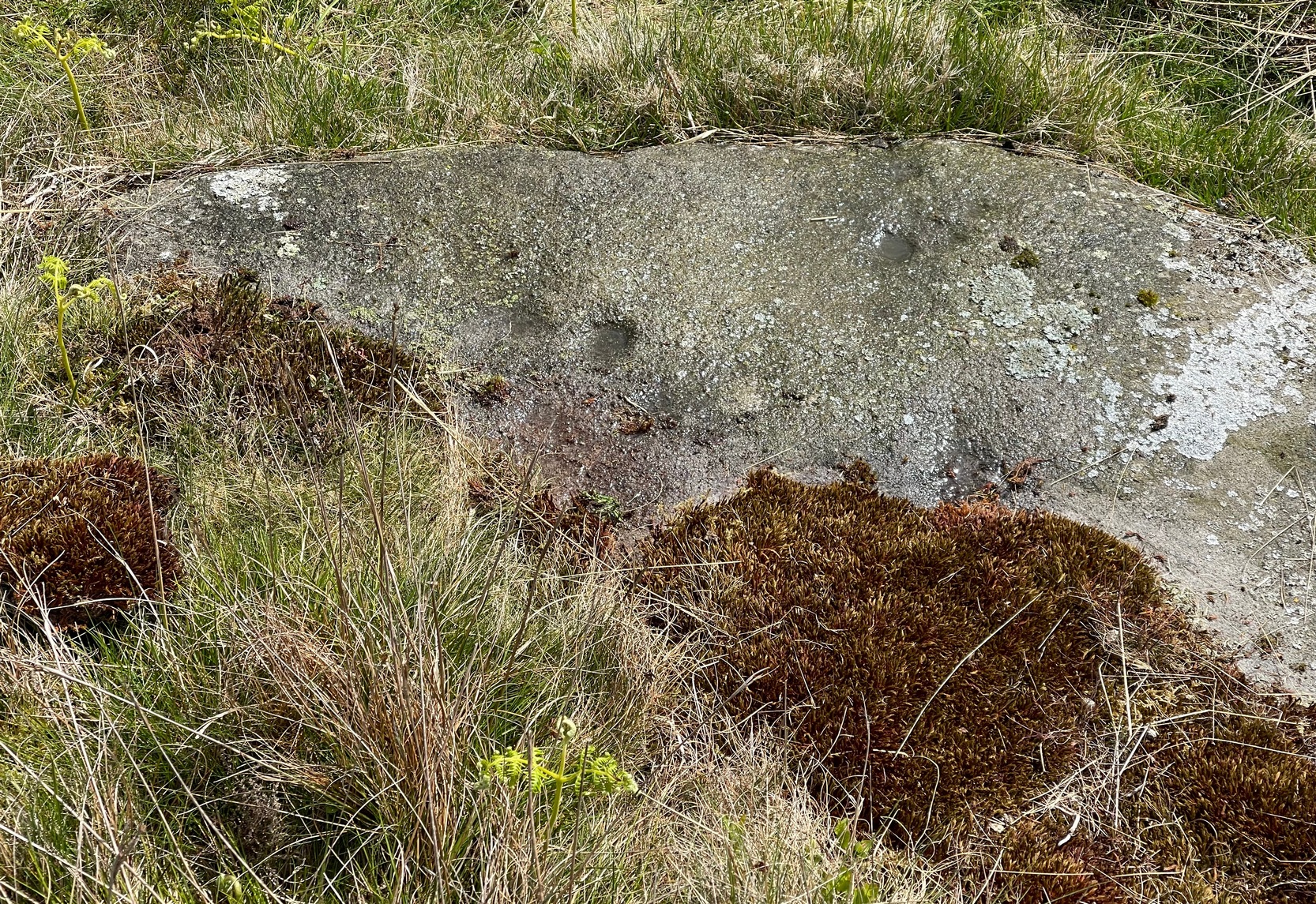
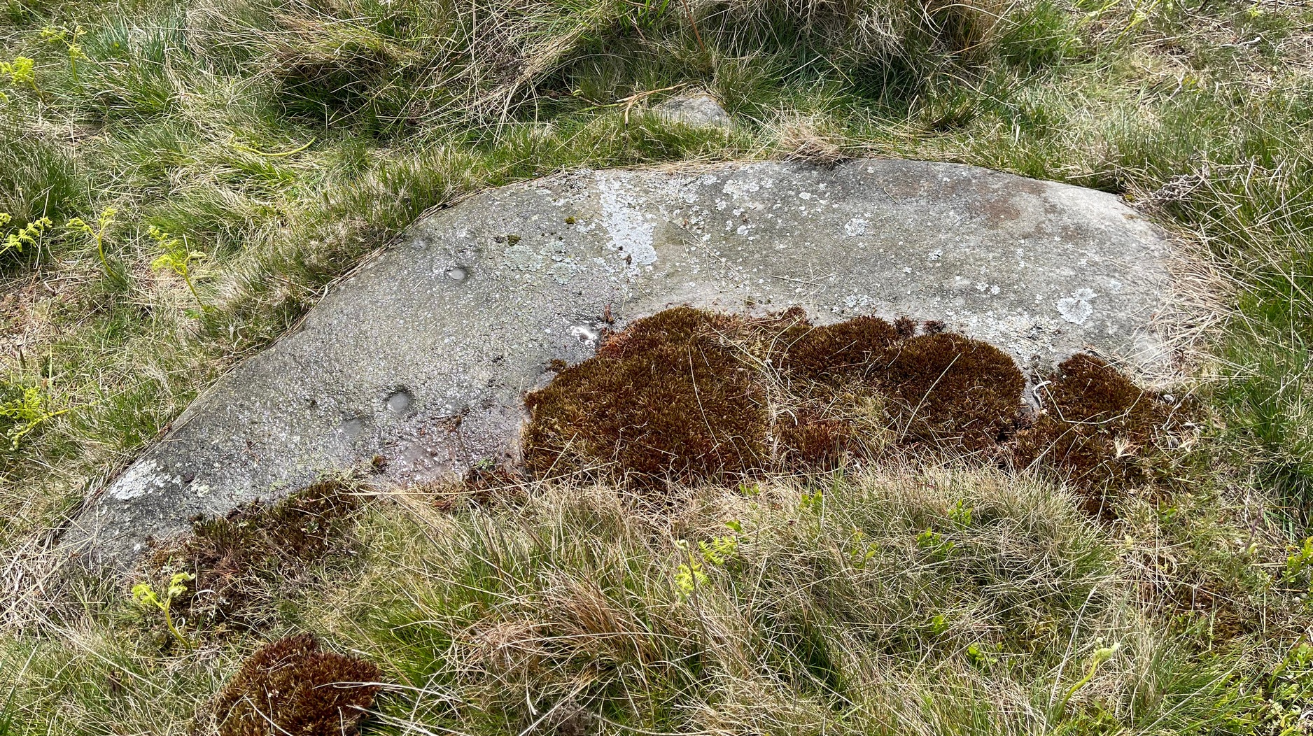
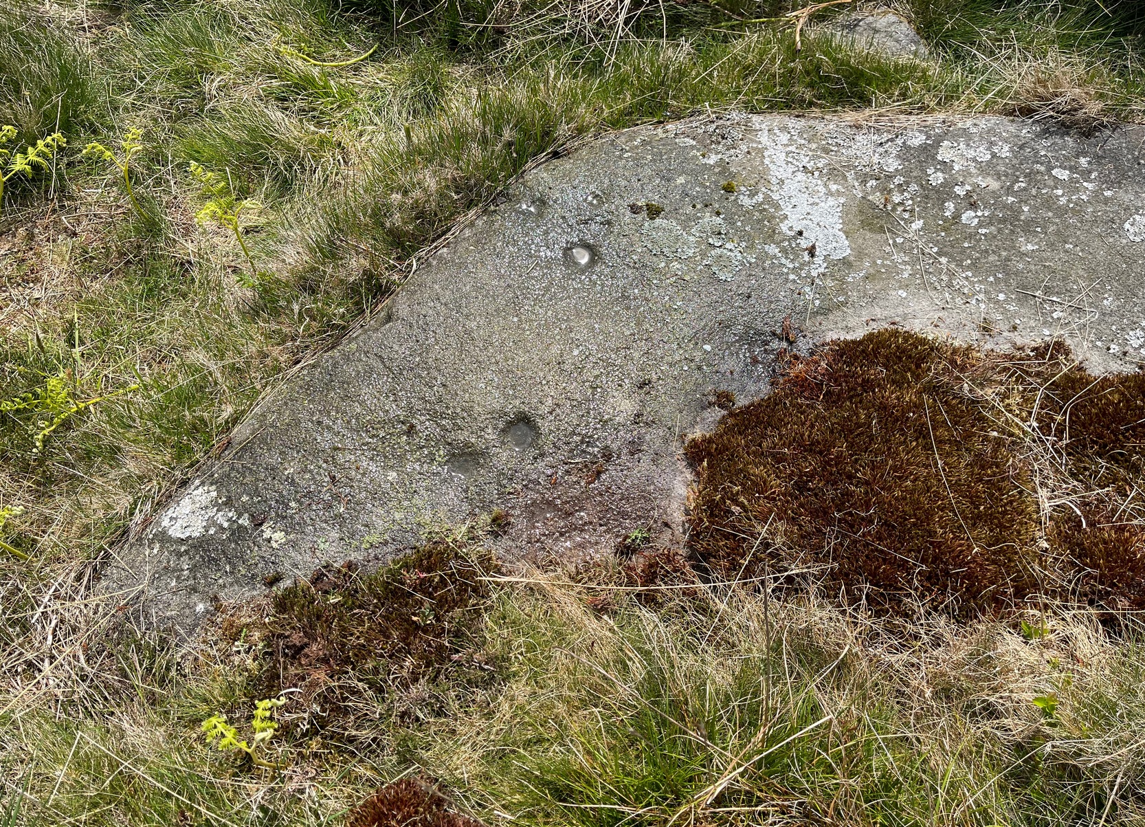
If you’re looking for this carving, you’ll have been to the impressive Tree of Life stone first. From there, you need to walk further away from the walling, 30-35 yards southwest, across the other side of the footpath. There’s a scattered mass of stones all over the ground here: you’re looking for a low-lying long curved stone—longer than most of them hereby. If the heather’s grown back over the stone, it might take some finding!
Archaeology & History
Close to a line of prehistoric walling (seemingly a section of a settlement), this typically curvaceous female stone is possessed of two pairs of faint cup-marks on the eastern side of the rock. It was included in Boughey & Vickerman’s (2003) survey where they described the carving as being, “two small cups visible and two further cups under heather.” A third possible cup exists close to one of the pairs. The carving is found in an area rich in untouched prehistoric remains.
References:
Boughey, Keith & Vickerman, E.A., Prehistoric Rock Art of the West Riding, WYAS 2003.