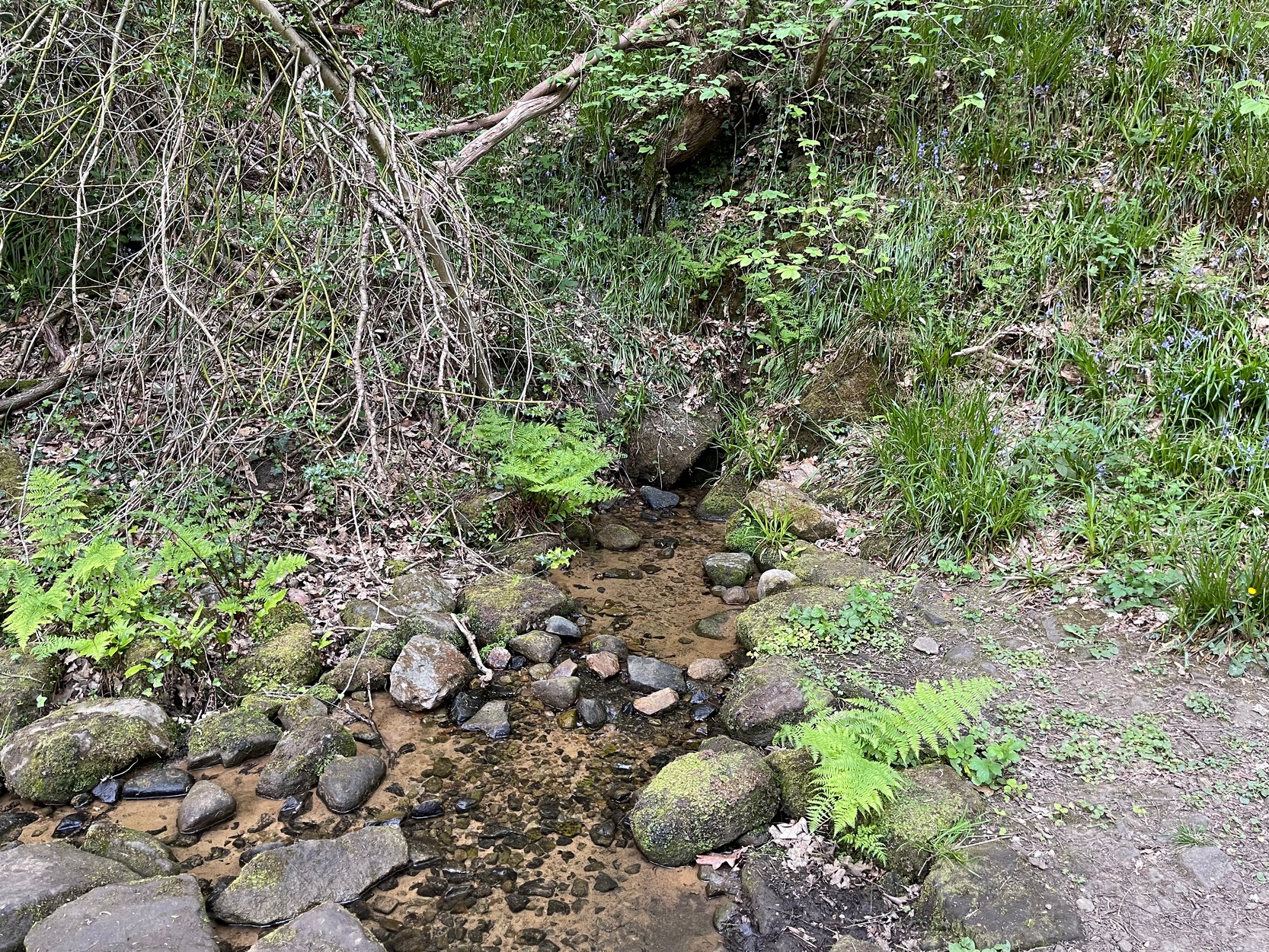
My walk up to this place took me off the main A6038 Hollins Hill road, across from the petrol station and up the scruffy disused road to the hamlet of Tong Park, bending round the houses to the right when they appear. Keep along this old track, then veer right, down the slope and along the footpath and into the trees under the railway arches, keeping on until you reach the lake on your left. At the end of the lake, cross the bridge and follow the footpath as it bends to the left and into the trees. You’ll go over a stile and then about 50 yards along, the stream that crosses the path emerges from a crack in the rocks on your right. You’re here!
Archaeology & History
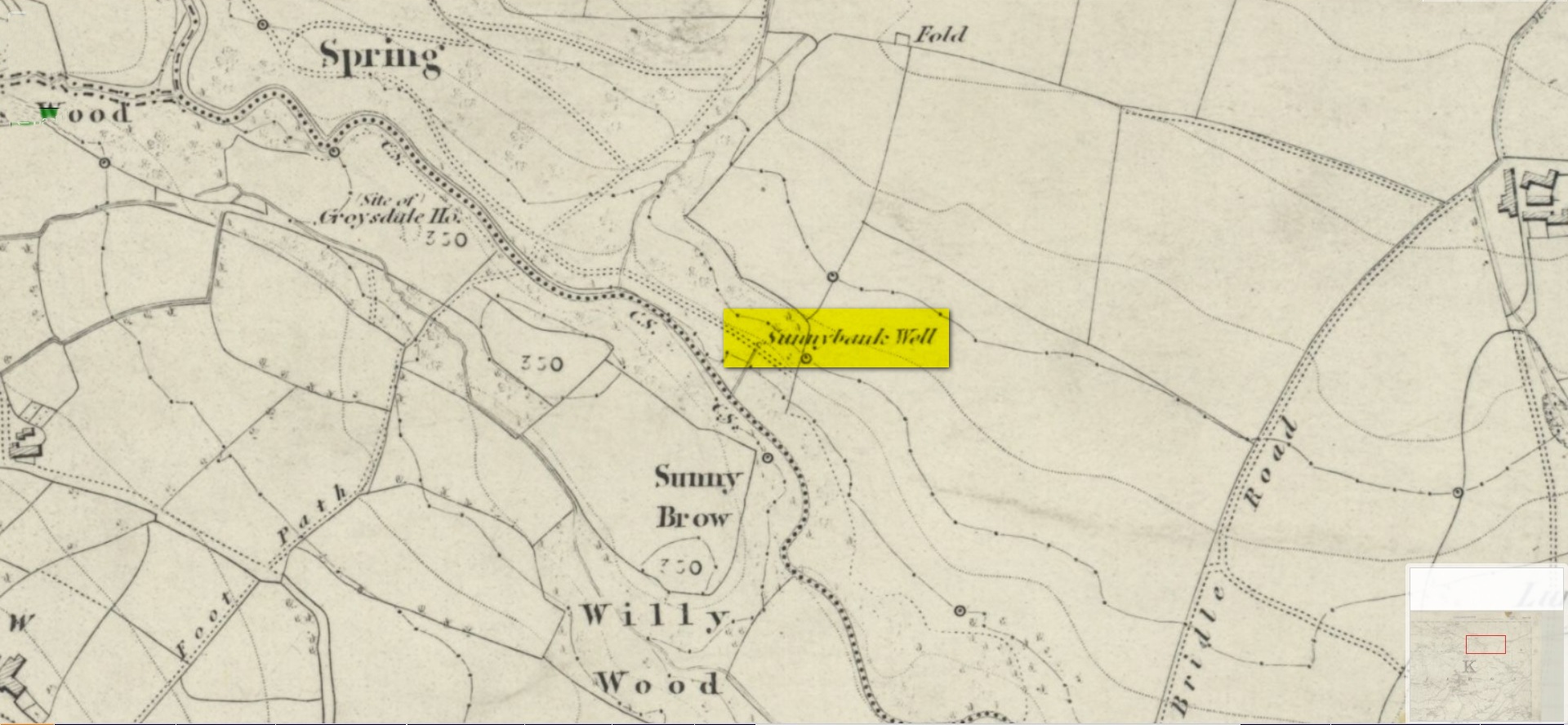
Site shown on 1852 map
All history and tradition of this site seems long gone. It was shown on the 1852 Ordnance Survey map of the region and doubtless receives its name from the location, as the spring of water emerges from beneath the sloping embankment which is a bit of a sun-trap in Spring and Summer. It makes sense. Although I can find no reference to any medicinal attributes, the waters of Sunnybank Well are cold, fresh and drinkable.
References:
Shepherd, Val, Historic Wells in and Around Bradford, HOAP: Wymeswold 1994.
Acknowledgements:Huge thanks for use of the Ordnance Survey map in this site profile, reproduced with the kind permission of the National Library of Scotland.
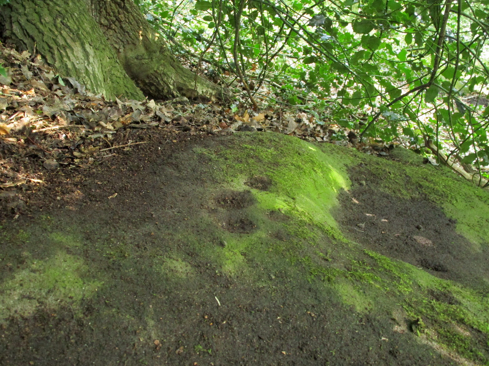
You can take the same directions to get here is you follow the route for the Hawksworth Spring (01) carving, or take this alternative route. Take the standard road from Guiseley along Hawksworth Road. When you reach the first row of old houses in the village, a couple of hundred yards on you reach the village school and, shortly after the footpath is sign-posted. Walk left (downhill) through the field for half-a-mile until you reach the woods. 100 yards into the into the trees, walk to your right and follow the line of walling straight for 400 yards, then veering right up the slope and it then slowly bends round, keeping to the wallside all along. It then starts heading back downhill. As it does so, 10 yards from the wall into the woods you’ll see the broken triangular rock of the Hawksworth Spring (01) carving. Walk another 10 yards where the large holly bushes are and you’ll see the large sloping stone in front of you.
Archaeology & History
This carving is similar in nature to its companion 10 yards away, inasmuch as each of them possess two small arcs of cup-marks almost in the same format, very close together, one above the other near the top of the stone. It’s possible that the mythic nature/function of this particular element of arcs is the same on each stone—although fuck knows what it might be!
Clear line & faint line of arcsClear arc of cups
Below this double arc (only one of which is clearly visible in the photos) we see a scatter of other cup-marks—perhaps six, perhaps seven—one of which appears to have a very faint incomplete ring round it. When Liz Sykes and I visited the place, the light of day and the shadows across the rock didn’t help to convince us one way or the other, so we await news from other visitors who get better light conditions to tell us whether our hopeful eyes were deceiving us or not. There are a number of other marks on its surface, but these are much more recent and very obviously cut, or rather scratched, by metal artifacts with no bearing on the prehistoric design.
References:
Boughey, K.J.S. and Vickerman, E.A., Prehistoric Rock of the West Riding (Supplement), Shipley 2018.
Acknowledgements: Huge thanks to Liz Sykes for her renowned cleaning skills!
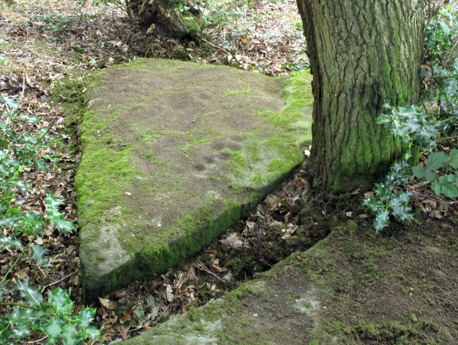
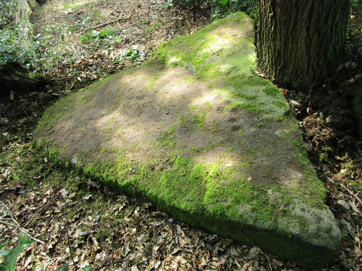
Through Baildon town centre, take the road onto Baildon Moor, but instead of turning left up to Baildon Hill, keep straight on the Hawksworth road and 100 yards along you’ll see a car-park is on the right-hand side, just before you start going downhill. From here, walk down the road a couple of hundred yards until you see the footpath (keep your eyes peeled!) turning right towards The Whitehouse, and from there take the footpath dead straight down to the woods below. Cross the stream, turn right, then immediately left uphill by the wall-side. Shortly before reaching the top you’ll see a large triangular sloping slab of rock with a tree at its top. That’s it! Alternatively you can come via Hawksworth village by following the directions to the Hawksworth Spring (02) carving, which is just 10 yards east of this one. Easy!
Archaeology & History
Sketch of carving (after Hedges 1986)Note the faint cup, top-right
This minimalist design is best seen from above the adjacent rock which, in times gone by, was attached to this very same stone. The main aspect of the carving are the two short rows of three cups, running almost alongside each other, in a likeness which my compatriot Liz Sykes said “was like some animal footprints.” It’s not a bad description to be honest (this same motif is found on a companion petroglyph just a few yards to the east: the Hawksworth Spring [2] stone). If you follow the direction of the “animal tracks” to the western end of the stone, you’ll see another isolated cup with a faint incomplete ring around it. You can just make it out on the photo to the right. Another single cup-mark seems apparent two-thirds the way down the stone.
References:
Hedges, John (ed.), The Carved Rocks on Rombalds Moor, WYMCC: Wakefield 1986.
Acknowledgements: Huge thanks to Liz Sykes for her renowned cleaning skills!
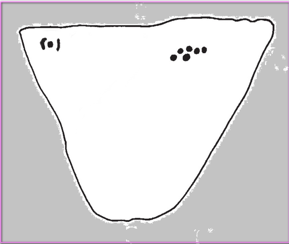
Cup-Marked Stone (missing): OS Grid Reference – SE 1687 3868
Archaeology & History
Sketch of the missing cup-marked stone
This carving was originally located somewhere close to the old disused Brackenhall Mills on the edge of Thackley, just before you drop down to Thackley tunnel. It was uprooted sometime in the 1950s and taken several miles away to the Cartwright Hall Museum at Manningham, Bradford, where it sat outdoors behind some fencing for many a-year, accompanied by the large fossil of an ancient tree.
I first saw it there when I lived close by in 1981, in the days before I had such a thing as a camera. Hence I only have this scruffy old sketch of the design, which I did without adding any notes to help remind me which carving it was! So this sketch has sat, all-but-forgotten, on a scrap of paper since then, until I recently sussed out which carving it was!
The stone itself was akin to a very large portable rock, with a simplistic design consisting of at least nine cup-marks cut into one of the rounded faces. One account of the stone suggested there may have been a possible incomplete ring around one of the cups. When I went back to see the stone about 20 years ago, it had gone. So I called into the adjacent museum to inquire what had become of it. The curator (or whoever it was) that I spoke with told me that the stone had been put into a box and placed in the cellars, but refused to let me see it. I asked to make an appointment to see the stone and he refused that too. It has not been seen since. Does anyone know what’s become of it?
References:
Keighley, J.J., “The Prehistoric Period,” in Faull & Moorhouse’s, West Yorkshire: An Archaeological Survey to AD 1500 (WYMCC: Wakefield 1981).
Healing Well (destroyed): OS Grid Reference –SE 1672 3866
Archaeology & History
Along the footpath below the family graveyard at Thackley, the great genealogist and industrial historian J.H. Turner (1878) told that, “at the right hand side of the wood, at the bottom, is Scout Willie’s Well, formerly noted for its medicinal properties” – though whatever curative aspects it possessed have long since been forgotten. It was also known as the Sweet Willie Well. I perused the woodlands here searching for the well in my younger days but could find no trace of it; nor is anything shown on the early OS-maps of the area.
References:
Turner, J. Horsfall, Idle Upper Chapel Registers and Graveyard Inscriptions, Bingley 1878.
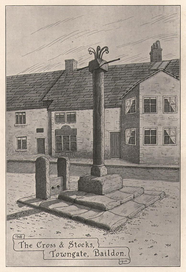
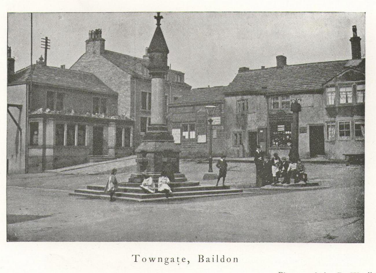
Located next to the old stocks by the main roundabout right in the middle of the town is this tall market cross, nearly ten feet high and well known to the local people. It has been described by several local historians, although its recognition as a “market cross” is slightly contentious as it seems there are no written records to indicate that a market ever existed here. The great Baildon historian, W. Paley Baildon (1912) was unable to find any info about such a market, commenting simply that “most villages…had crosses in medieval times, many of which still exist; so that the presence of a cross at Baildon is (not necessarily) evidence of a market.”
His description of its form is as valid then as it is to this day:
Old sketch, c.1900Old photo of the cross c.1900
“The cross, as we see it to-day, is not an interesting object. The square platform of two stages, with its well worn stones, looks as though it might be medieval, and part of the original work. In the centre of this is a large square block of stone, from which rises a tall cylindrical shaft.
The base is square, with chamfered corners, and a plain roll moulding at the upper edge; the cap is a plain square block, without any attempt at ornament.”
One of Bradford’s industrial historians, William Cudworth (1876) thought that the present cross replaced an earlier one, and that this one was erected by a member of the wealthy Butler family a few centuries ago. Mr Baildon wasn’t quite as sure as Mr Cudworth. Nevertheless they both agreed that this edifice replaced an earlier one. Baildon said:
“My own view is that there was probably a cross here in medieval times; that it was destroyed, either after the Reformation (as so many were), or by the Puritan soldiery during the Civil War; that the steps and perhaps the base remained; and that in the eighteenth century, when the Butlers were one of the leading families in the place, one of them may have erected a new shaft on the old site.”
In much earlier days it was said to have been surrounded by a grove of trees and a brook ran by its side. Villagers would gather here as it was “a favourite gossiping resort.” At the beginning of the 20th century, an old gas light surmounted this old relic.
References:
Baildon, W. Paley, Baildon and the Baildons – volume 1, St. Catherine’s Press: Adelphi 1912.
Cudworth, William, Round about Bradford, Thomas Brear: Bradford 1876.
la Page, John, The Story of Baildon, William Byles: Bradford 1951.
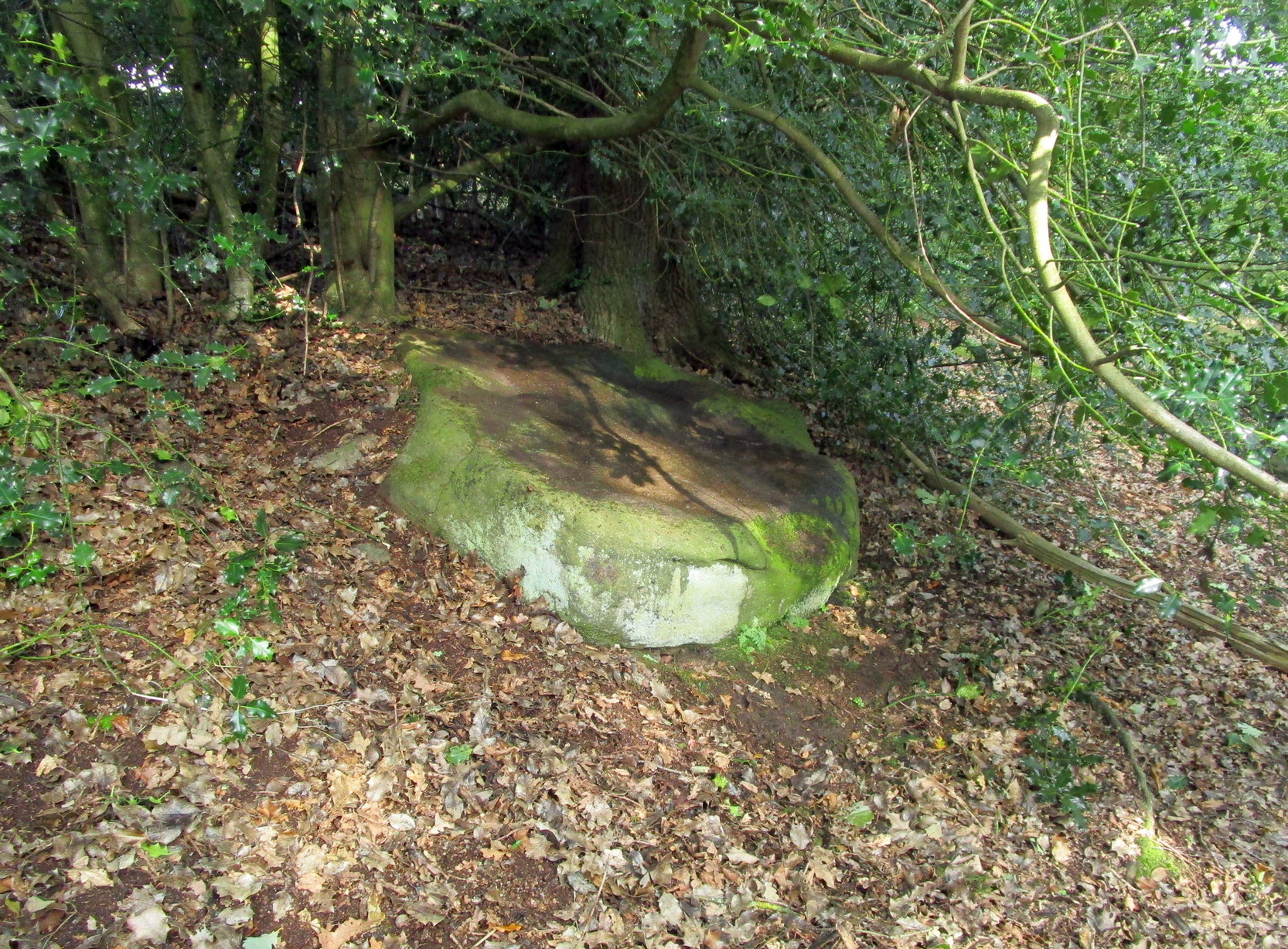
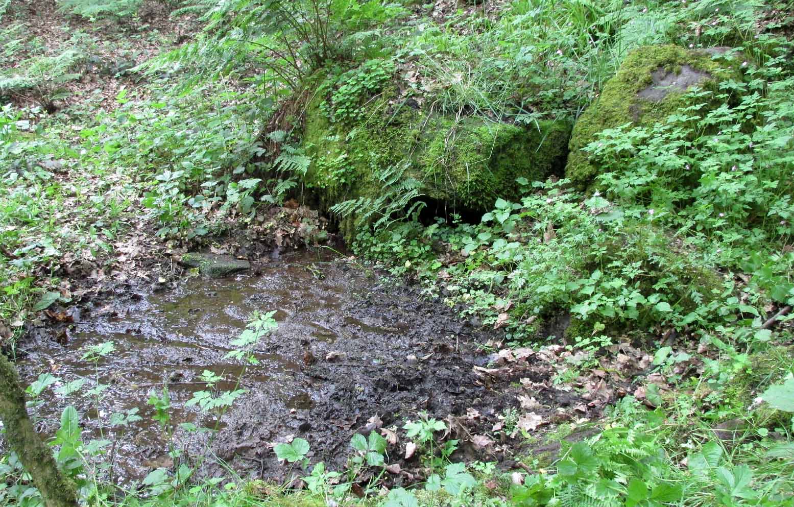
Best reached by going up Shipley Glen, to the Brackenhall Circle enclosure; keep going for a couple of hundred yards and then drop down into the trees, taking the directions directly to the Cloven Hoof Well. Just past the well, a small footpath leads you downhill towards the large stream at the bottom, where there’s a rocky crossing (an old ford). Go over here and, barely 50 yards upstream to your right, a large singular moss-covered boulder is set back, just a few yards above the stream with a small pool in front of it. That’s it!
Archaeology & History
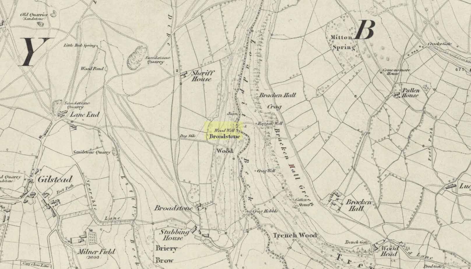
The ‘directions’ to find this might seem a little confusing to locals at first. This is because the whereabouts of the Wood Well is on the eastern boundary edge of Gilstead – which is down at the bottom of Shipley Glen. The steep muddy hill above it is almost always slippy and wet through, so it’s easiest to approach from the Baildon side.
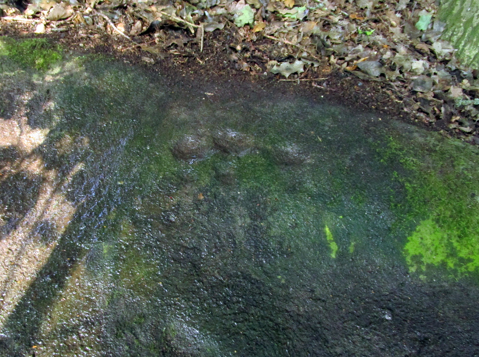
The shallow muddy waters in a hot summer
The site is shown on the 1852 map of the area, but I can find no written material telling of its qualities. If it ever had any medicinal virtues, they have long since been forgotten. Whilst the water here is fresh and drinkable, in times of drought and low rainfall the water subsides and leaves only a muddy pool – just as it was when I last visited, making it quite undrinkable. But to me, the main aspect of this site is its natural spirit, its locale, as it’s surrounded by unerring hues of rich greens, cast out by the landscape of mosses prevalent in a region almost bereft of such voices. If you like y’ wells – check it out!
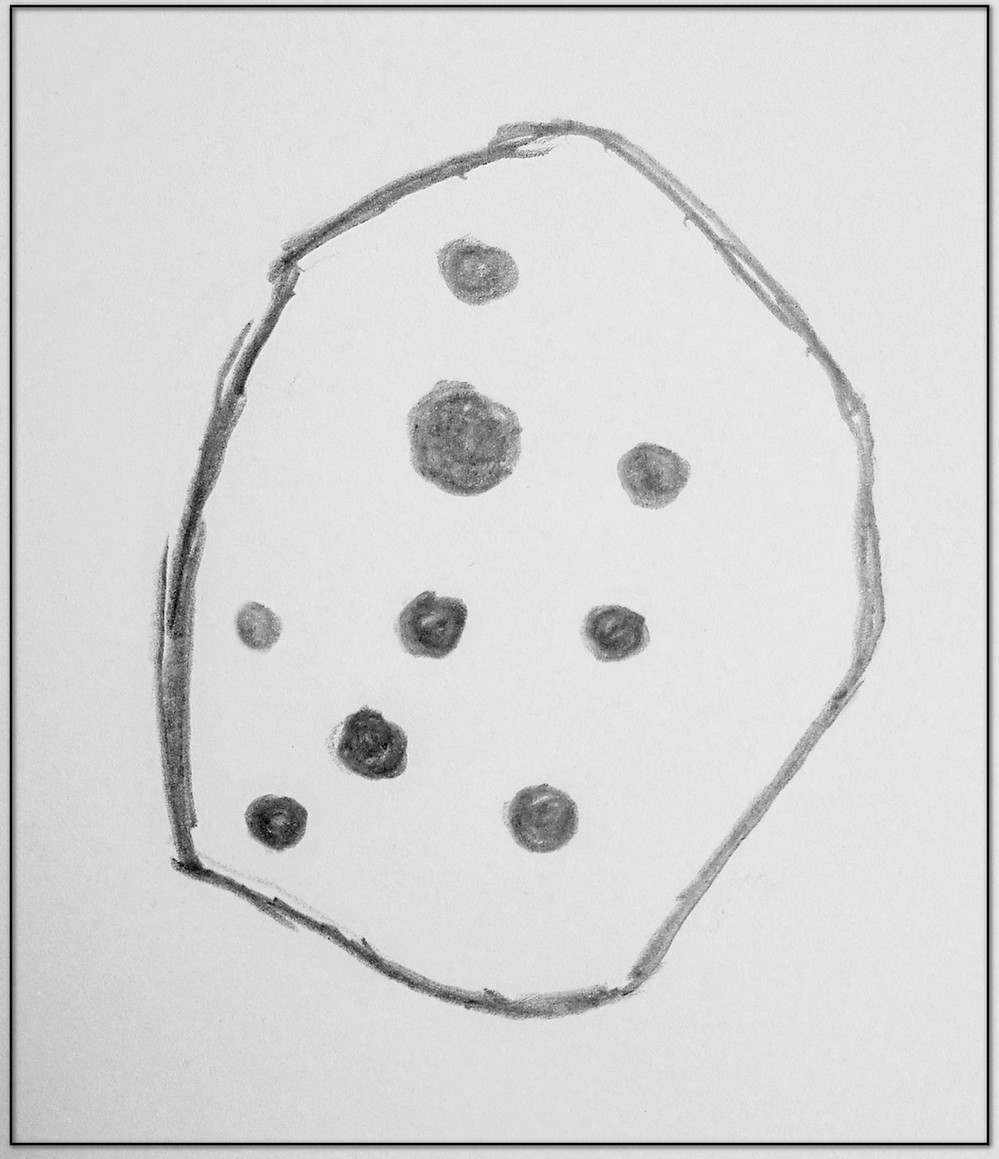
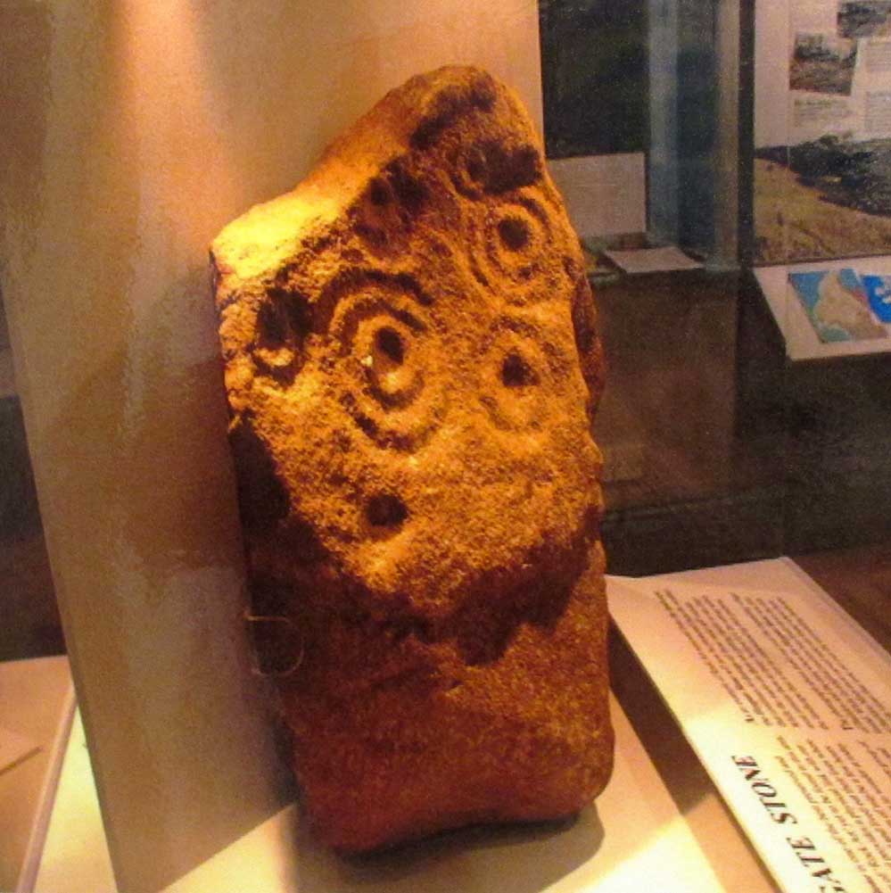
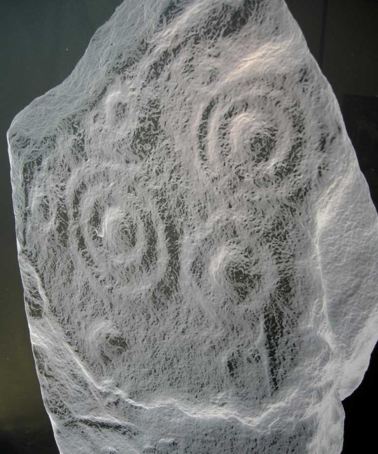
This excellent cup-and-ring marked petroglyph was found fortuitously in September 2001 by the land-owner at Near Hey Gate field to the northeast of Baildon village. He was clearing out remains of some old walling in the field and, adjacent, a rock that was protruding out of the ground got turned over. Underneath it he noticed a series of very well-preserved cups and rings in a cluster near one part of the rock. It was a bittova beauty to be honest!
Thankfully due to the subsequent efforts of local rock art students Mike Short and Keith Boughey, it was later re-housed in the Brackenhall Centre at the edge of Shipley Glen.
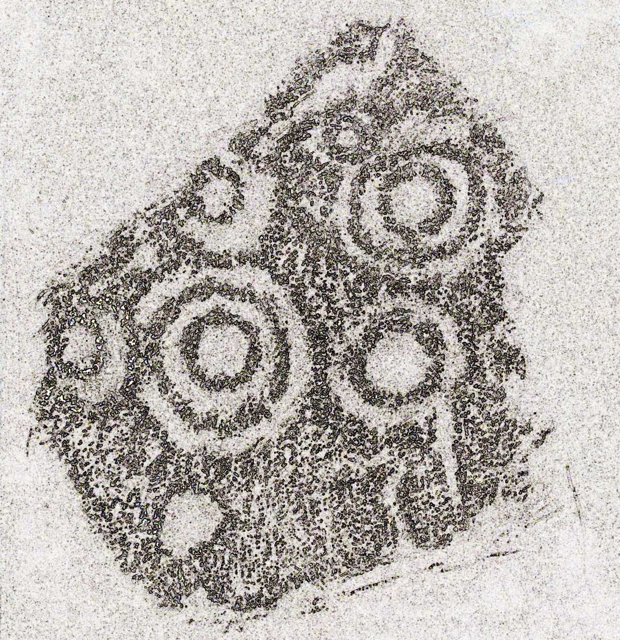
Enhanced rendition of Boughey’s Heygate Stone rubbingComputer-enhanced image of the carving
The stone itself was once larger than it now is and may have had additional carved elements on it, but the other portion that had broken off wasn’t located when it was first dug out of the ground. This may mean that it was moved here from another location, which would have been somewhere close by. Many other petroglyphs exist in and around the Baildon district.As we can see in the images here, two very well-defined double cup-and rings have clusters of smaller singular cup-and-rings around their edges. A single cup-mark was etched below the largest of the double-ring carving, and what seems like a carved straight line emerges from the largest of the single cup-and-ring.
Holy Well (destroyed): OS Grid Reference – SE 1609 3961
Archaeology & History
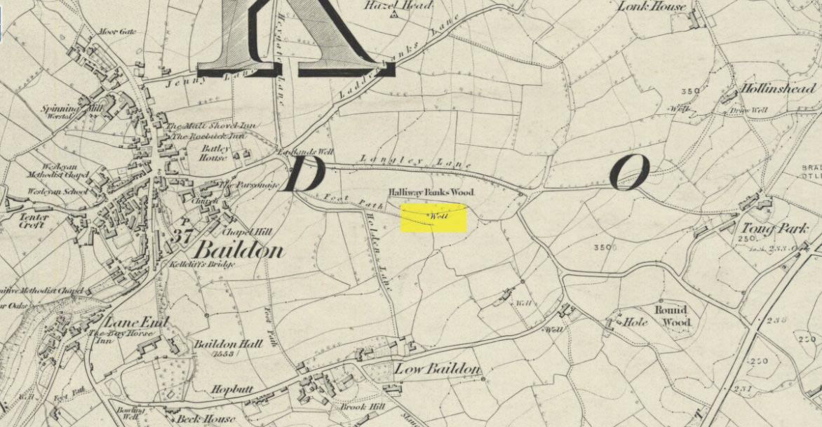
This site is all but unknown to the great majority of folk in Baildon, and even some of the local historians have let it slip from their investigative tendrils. According to the primary Baildon historian, W.Paley Baildon, it was first known as the ‘Halliwell Holy Well’. In his magnum opus (1913-26) of the township he relates that,
“The 1852 Ordnance map marks Halliway Banks Wood to the south of Langley Lane, with a well just below it, and a footpath from Holden Lane to the well. Halliway, I think, is a corruption of Halliwell, the ‘holy well,’ with the special footpath leading to it and nowhere else. Haliwell Bank occurs in (the Baildon Court Rolls of) 1490, when it formed part of the property held by William Tong of Nicolas Fitz William.”
This etymology is echoed by the great place-name authority A.H. Smith (1954). It also caught the attention of archaeologist Andrea Smith (1982), in her investigation of twenty-five holy wells in the West Yorkshire region.
“Many wells,” she wrote, “are recorded simply as ‘Holy Well,’ or the various forms ‘Halliwell,’ ‘Helliwell’ and ‘Hollowell.’ It is possible that in these instances the identity of the patron saint or guardian of the well has been forgotten, which may be the case with the site at Collingham, now known as Hollowell.”
Site of the Holy Well in 1852
The well itself can no longer be seen. When I looked for the site in 1982, I found that to the right of where the 1852 map showed it, was a waterworks lid covering the old holy waters, just in the trees atop of the field beneath a great sycamore with a number of small stones roughly encircling the site: perhaps the only possible relics of the century before when the waters would have been used. A stone trough was situated at the bottom of Holden Lane, fed by the waters from the Halliwell and from here the course of the stream meandered down the side of Slaughter Lane, now known as Kirklands Road. The land around Halliwell became known as Kirkfield, or field of worship.
A local resident told how during autumn and winter, the left side of the field gets extremely boggy – the region were the old stream ran from the old well, along which dowsers have found aquastats abound. Now however, houses have been built where the waterworks-lid used to be and is likely to be in someone’s backyard, all but forgotten.
Folklore
According to local lore, the site of this most ancient of holy wells was found in the warmest place in the Baildon district. Whilst its geographical position doesn’t necessarily suggest this (although it did face south, into the sun), this lore may reflect some healing aspect of the well that has long since been forgotten.
Perhaps relevant to Andrea Smith’s comment about there being ‘guardians’ at holy wells is found in folklore relating to nearby Holden Lane: locals in the last century also referred to it as Boggart Lane, so called after the Boggart which was seen there in the form of a spectral hound that was said to possess large glowing red eyes and was a sign of ill omen. Modern sightings of the spectral hound, which appeared along the road which led to the old well, are unknown.
References:
Baildon, W. Paley, Baildon and the Baildons (parts 1-15), St. Catherines: Adelphi 1913-26.
Smith, A.H., English Place-Name Elements – volume 1, Cambridge University Press 1954.
Smith, Andrea, ‘Holy Wells Around Leeds, Bradford & Pontefract,’ in Wakefield Historical Journal 9, 1982.
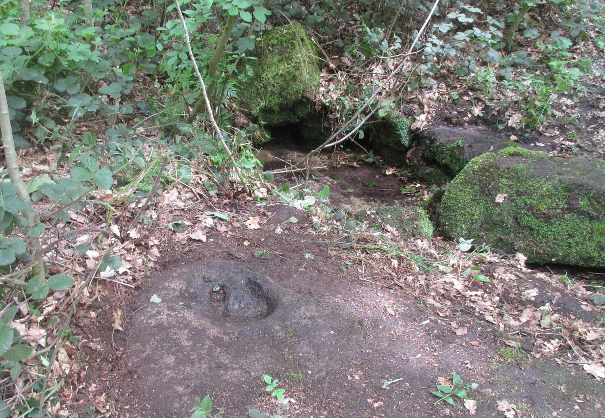
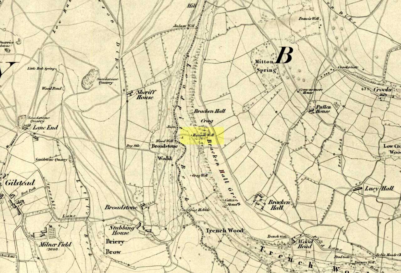
On the roadside at Shipley Glen, from Brackenhall Circlewalk up for about 250 yards, where you’ll notice the land dips as it drops into the woods below. Follow this dried stream down until you reach the mossy Loadpit Beck in the valley. By the waterside is a footpath: follow this upstream for a short distance, keeping your eyes peeled on the Earth below where a smaller stream crosses the path you’re walking on. Follow this uphill to its source!
Archaeology & History
Halfway up (or down) the moss-covered waters of Shipley Glen the all-but-forgotten waters of the Cloven Hoof Well still flows nice and freely, and is still good to drink. It was shown on the first OS-map of the area in 1852, where it was called the Raygate Well, whose derivation neither the great Baildon historian W. Paley Baildon nor the place-name giant A.H. Smith could account for. It sounds just like it was someone’s surname, but local genealogy cannot affirm this. One possibility—and which reflects in the local lore of the site—is that it’s a compound word from the old northern dialect word Rea, “an evil spirit or demon”, and gate, “a hole, an opening or gap.” The terms are used in a prayer given in Mr Sinclair’s Satan’s Invisible World Displayed (1814),
“as recited in the time of Popery by persons when going to bed, as a means of them being preserved from danger:
“Keep this house from the weir… And from an ill Rea, That be the gate can gae.””
But this purely speculative….
Cloven Hoof Well on 1852 map
A photograph and brief description of the Cloven Hoof Well was given in an early edition of the Bradford Scientific Journal after a geological excursion to Shipley, though nothing was said of its curious name. However on a rock below the spring, a hoof-print mark is clearly seen. It appears to be part-natural and partly enhanced. This is an area rich in prehistoric petroglyphs, or cup and rings stones.
Mosses thankfully still cover the rocks from whence the waters flow; and bilberry, blackberry, male fern and bracken also grow around it. Psychoactive plants also abound nearby. The water is healthy and never seems to dry up, even during long warm summers. And below here, on the other side of the stream at the bottom, you can visit the little-known Wood Well.
Folklore
Local lore told that the devil stepped here and left his hoof-mark in the rock, making the waters rise from the Earth. Possibly a venerated site in earlier days, one finds numerous ancient remains nearby (cup and rings, stone circle, walling, cairn fields). Pagans amongst you should love this place!
References:
Armitage, Paul, The Holy Wells and Healing Springs of West Yorkshire, forthcoming
Baildon, W. Paley, Baildon and the Baildons (parts 1-15), St. Catherines: Adelphi 1913-26.
la Page, John, The Story of Baildon, William Byles: London 1951.