Whether you’re coming here from either Baildon, or Shipley, head for the Cricketer’s Arms on Green Road (ask a local). About 50 yards uphill from the pub, on the other side of the road, notice the small pool on the green surrounded by large rocks. That’s y’ spot!
Archaeology & History
First illustrated on the 1851 6-inch to the mile Ordnance Survey map of the region, this little known medicinal spring of water appears to get its name from the northern dialect word, crutch, meaning a plough, a plough-handle, a spade and variants thereof. (Wright 1898) There is another possibility of it deriving from “an ash or hazel pole” that were given as payment to workers each day in bygone times—a curious custom in itself! But we actually don’t know for sure and could even assume that people came here on crutches to be cured, or something along those lines.
The place has clear running water and had a chapel built near it in the early 19th century. The old public house across the road (Cricketer’s Arms) has spring water from this well running underneath it, which was said to never run dry and also keeps the drinks forever cool in warm weather! A few yards above the source of the spring, on the grass to the north is a small cup-marked stone. Another cupmarked rock listed by archaeologists as a prehistoric carved stone nearby on the same grass verge is probably of more recent industrial origin.
References:
Baildon, W. Paley, Baildon and the Baildons – parts 1-15, Adelphi: London 1913-1926.
Wright, Joseph, English Dialect Dictionary – volume 1, Henry Frowde: Oxford 1898.
Whether you’re coming here from either Baildon, or Shipley, head for the Cricketer’s Arms pub on Green Road (ask a local). About 50 yards uphill from the pub, on the other side of the road, notice the small pool on the green surrounded by large rocks: it’s the small stone about 15 yards behind the source of the spring. The goats living there usually give the game away!
Archaeology & History
This small stone, found amidst a cluster of others surrounding the medicinal Crutch Well, has its name from the friendly goats who live hereby and, when I came here for the first time in a while the other day, had trouble getting one of the little fellas to shift from his stone! We first found this when we did a lotta venturing around the area when we lived nearby as kids. This particular stone was noted during one of our many exploratory rambles round here, albeit briefly, when I wrote:
“Before going up the slope to Robin Hood’s House we looked at the stones around Crutch Well and found one with some cup-marks on it, on the grass behind the waters.”
I can’t say for sure, but think this carving was later added in the Boughey & Vickerman (2003) survey as stone no.193. They described the stone as:
“Creamish coloured rock about 1m N-S and less than 0.5m high carries two possible shallow cups to centre of surface and a possible third cup (doubtful) to N.”
Close-up of the cups
This would seem to be the stone, though there is another faded fourth cup, between the ‘doubtful’ cup and the two distinct ones, with a faded carved line running from it. Their grid-reference isn’t accurate for this and a companion single cup-marked rock (which I’d say was dodgy!), so I’m not 100% sure that we’re dealing with the same carving. There are a lot of small rocks here and in the fields opposite, many with industrial marks on them which, over the years, have faded and give the appearance of cup-markings — which most are not!
References:
Bennett, Paul, Of Cups and Rings and Things, unpublished: Shipley 1981.
Boughey, Keith & Vickerman, E.A., Prehistoric Rock Art of the West Riding, WYAS: Wakefield 2003.
From Baildon go up onto the moor, turning left to go round Baildon Hill and onto Eldwick, stopping at the car park at the top of the brow where the Acrehowe circle once stood. Cross the road and walk along past carving 184, making sure you keep right sticking to the footpath that runs along the edge of the slope (not onto the flats & up to Baildon Hill itself). There are several carvings along here, but this one’s on the right-side of the widening path, another 300 yards past carving 184. Keep your eyes peeled – y’ can’t really miss it!
Archaeology & History
Carving 173, looking S
In my 1982 notebook I described this as “a very well-preserved cup-and-ring stone, with two cup-and-rings and seven other cup-marks. There seems to be faint remains of other lines carved by some of the cups.” And the description is as apt today as it was back then – though neither of the surrounding ‘rings’ are complete. However, as the photos here indicate, adjacent to the main cup-and-ring near the centre of the stone another incomplete cup-and-ring is evident, emerging from the natural crack that runs across it. In the subsequent surveys of Hedges (1986) and Boughey & Vickerman (2003) they somehow only saw one cup-and-ring on this rock. Easily done I suppose! In certain light there’s what may have been an attempted second surrounding ring starting on one of the cups…but I’ll leave that for a later date…
CR-173 (after Hedges)Slippery when wet!
There may also have been intent to carve another ring around one of the other cups on the northern half of the stone. This possible fourth ring and its position on the stone potentiates solar symbolism (not summat I’m keen on, tbh), which fits into the position and nature of several other cup-and-rings in this region and which I’ll expand on and highlight a little later on. It is important to remember that this petroglyph and its nearby relatives were once accompanied by a series of tumuli, or prehistoric burial mounds: a feature that is not uncommon in this part of the world. Well worth having a look at!
References:
Bennett, Paul, Megalithic Ramblings between Ilkley and Baildon, unpublished: Shipley 1982.
Boughey, Keith & Vickerman, E.A., Prehistoric Rock Art of the West Riding, WYAS: Wakefield 2003.
Hedges, John (ed.), The Carved Rocks on Rombalds Moor, WYMCC: Wakefield 1986.
Morris, Ronald W.B., “The Prehistoric Rock Art of Great Britain: A Survey of All Sites Bearing Motifs more Complex than Simple Cup-marks,” in Proceedings of the Prehistoric Society, volume 55, 1989.
From Baildon, take the road up onto the moors, turning left to go round Baildon Hill, then park-up at the small car-park on the brow of the hill at the edge of the golf course. Cross the road and take the well-trod footpath diagonally right, heading onto Baildon Moor. Walk along here for 300 yards and notice the large stone just to your right. You can’t really miss it!
Archaeology & History
Listed without real comment in several surveys, this large sloping rock that looks over the north and western landscapes of Rombald’s Moor and beyond, has several simple cup-markings on its surface, one with a faded ring around it. In more recent centuries, someone began to add their own etching onto the stone but, thankfully, stopped before defacing the ancient markings. I noted this carving in one of my early notebooks, saying only that it “lacked the central design found in others from this region,” being little more than a (seemingly) disorganized array of several marks.
Hedges 1986 drawingCups & faded ring
A greater number of other carved stones scatter the grassy flatlands west and south of here, some of which are found in association with prehistoric cairns and lines of walling; but no such immediate relationship is apparent with this particular stone.
References:
Bennett, Paul, Of Cups and Rings and Things, unpublished: Shipley 1981.
Bennett, Paul, Megalithic Ramblings between Ilkley and Baildon, unpublished: Shipley 1982.
Boughey, Keith & Vickerman, E.A., Prehistoric Rock Art of the West Riding, WYAS: Wakefield 2003.
Hedges, John (ed.), The Carved Rocks on Rombalds Moor, WYMCC: Wakefield 1986.
Morris, Ronald W.B., “The Prehistoric Rock Art of Great Britain: A Survey of All Sites Bearing Motifs more Complex than Simple Cup-marks,” in Proceedings of the Prehistoric Society, volume 55, 1989.
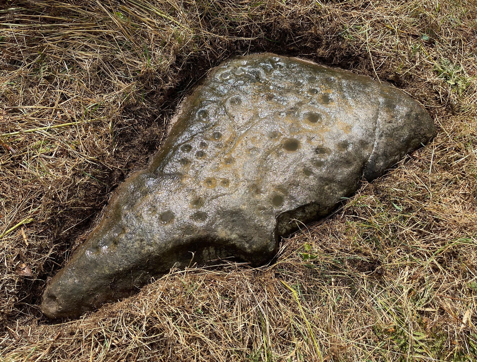
Take the road up alongside and past Shipley Glen, taking the turn to go to Crook Farm caravan site. Go right to the very end of the car-park, then walk up the footpath through the trees on your left. Keep going uphill about 100 yards by the field-wall until the land begins to level out – and shortly before the first gate into the field (on your right) keep your eyes peeled for the triangular stone in the ground, barely 10 yards away from the walling. Alternatively, from the entrance into the Dobrudden caravan park walk to the far-end of the level area in front of the little cafe and walk along the footpath that crosses the grassland to the walling nearly 300 yards away (south). Follow the wall down below the gate and zigzag about. You’re damn close!
Archaeology & History
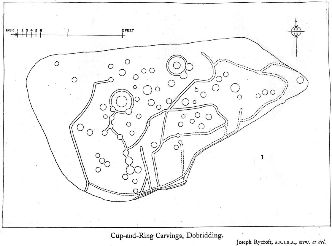
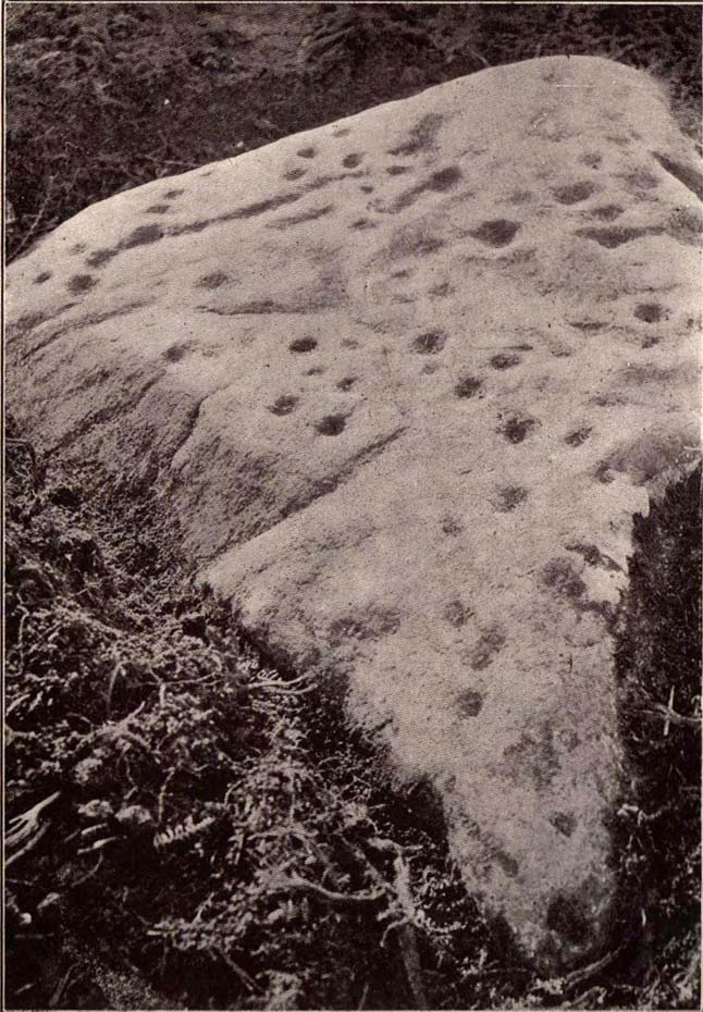
Crook Farm north carving
For some reason this has always been one of my favourite cup-and-ring stones on Baildon Moor and it’s well worth checking out if you visit the area! It was rediscovered by the Bradford historian W.E. Preston, who photographed the carving around 1912. Shortly afterwards he took fellow historians Joseph Rycroft and W. Paley Baildon to see this (and others he’d located) and subsequently both a drawing and Mr Preston’s photo of the site was included in Mr Baildon’s (1913) magnum opus the following year.
As you can see from the relative photos—with literally 100 years between them—erosion hasn’t taken too much toll and this neolithic or Bronze Age carving remains in very good condition.
Rycroft’s early drawingPreston’s 1912 photo
Covered with upwards of fifty cup-markings, there are also two cup-and-rings and numerous carved lines meandering around and enclosing some of the many cups. One cup-mark was cut into the narrow end or ‘nose’ of the stone.
It’s a fascinating design, with another ‘Cassiopeia’ cluster of cups in one section, beloved of archaeoastronomers who explore these stones. Mr Rycroft’s drawing of the design (left) is perhaps the best one, to date.
Along this same ridge there are remains of other prehistoric sites, more cup-and-rings, remains of prehistoric walling and what may be a small cairn circle (to be described later).
References:
Baildon, W. Paley, Baildon and the Baildons – parts 1-15, Adelphi: London 1913-1926.
Bennett, Paul, Of Cups and Rings and Things, unpublished: Shipley 1981.
Bennett, Paul, Megalithic Ramblings between Ilkley and Baildon, unpublished: Shipley 1982.
Whether you come via Shipley Glen or Baildon, head for the Dobrudden caravan park on the western edge of Baildon Hill. As you get to the entrance of the caravan site, turn right and walk along the outer walling of the caravan site, up and around for less than 100 yards. Keep your eyes peeled for the upright stone against the outer walling (the famous Dobrudden Cup-and-Ring Stone), and just 10 yards away, laid flat in the grasses, you’ll see this small cup-and-ring stone!
Archaeology & History
Found just a few yards from the well-known Dobrudden Carving that stands up against the wall, this small flat level stone, slowly again being encroached by Earth’s skin, is found on the edge of the High Plain, whereon the usual conjunction of prehistoric tombs and cup-and-rings is found once again. Whether this carving ever had its own cairn or funerary monument is now hard to say for sure; and the excessive erosion of modern humans is slowly eradicating the landscape all round here.
Jackson’s 1956 drawingHedges 1986 drawing
Consisting of two cup-and-rings (with very deep cupmarks in the centres), there are also what seem like artificially carved lines or grooves running across the stone. It was first described in a short article in the Cartwright Hall Archaeology Group Bulletin (Jackson 1956)*, found lying “in the path alongside the north wall of the Dobrudden Farm enclosure.” It seems like stone may have been covered over until some local work on Dobrudden unearthed it in the latter half of the 20th century. There’s also an intriguing note told by a local man called Jack Taylor, which Jackson narrated, saying how he,
“always held the opinion that the rings were not contemporary with the cups, and went so far as to suggest that they had been carved within living memory by someone anxious to ‘improve’ the boulder.”
This might be the case, as there is another carving not far away near the top of Baildon Hill that certainly seems to have been done in the 20th century. And one of the two surrounding rings on this stone does appear to have a more recent look to it than the other. However, we must consider that the covering soil has kept the carved rings in such good condition. (There are examples of petroglyphs throughout the world where certain carved elements were added at later times by countless aboriginal tribes.)
Close-up of cup-&-ringsDobrudden carving 150
Like all of these carvings, to get an accurate picture of the true original we must visit them in all weathers all through the year, to see how differing seasons express the petroglyph. For we can see on some images we have of this carving a number of features that aren’t on the drawings of either Jackson (1956) or Hedges (1986): whether the rings surrounding the cups are ancient or not, there is a definite carved line nearly linking them together; and at least one faint line stretches down from one of the rings. We need to visit the carving again to see if such features show up with greater clarity when lighting conditions are better.
References:
Baildon, W. Paley, Baildon and the Baildons – parts 1-15, Adelphi: London 1913-1926.
Bennett, Paul, Megalithic Ramblings between Ilkley and Baildon, unpublished: Shipley 1982.
Boughey, Keith & Vickerman, E.A., Prehistoric Rock Art of the West Riding, WYAS: Leeds 2003.
Hedges, John, The Carved Rocks on Rombald’s Moor, WYMCC: Wakefield 1986.
Jackson, Sidney, “Another Cup-and-Ring Boulder,” in Bradford Cartwright Hall Archaeology Group Bulletin, 1:13, 1956.
* Boughey & Vickerman (2003) cited W. P. Baildon’s magnum opus (1913) as the first to describe this stone, but this is untrue (there’s certainly no mention nor illustration of it in my editions of the Baildon volumes).
Whether you come via Shipley Glen or Baildon, head for the Dobrudden caravan park on the western edge of Baildon Hill. As you get to the entrance of the caravan site, walk down (left) the footpath outside the park itself, looking across the grasslands, left, to the tree-lined wall a coupla hundred yards away. Head for that. Then go through the gate into the field where you’ll see a denuded line of walling, with what looks like some standing stones along it. That’s where you need to be!
Archaeology & History
First noticed on February 12, 2012, this simple cup-marked stone is another one that’s probably only of interest to the purists amongst you. Found below the southern end of Baildon Hill, due west of the lost Hope Farm cup-and-ring stone, the cup-markings here are on the north-face of an upright stone in an old wall. It’s obvious that this stone was once earthfast, when the carving faced the zenith or night sky, and has been cut in half and turned 90° making the cups more difficult to notice; and very obviously the rock was originally close to its present position in the walling.
Primary cupmark, right-side of stoneClose-up of cup/s
Found in an area rich in cup-and-ring stones, there’s just one singular cupmark that’s obvious on this stone; but as we looked back and forth, feeling the stone with our fingers, it seemed there may be a couple of others on the rock. We need to come back here again in better lighting conditions, as opposed to the old grey day She gave us yesterday, and see if the others are real or simple geological marks.
From the famous Dick Hudson’s pub on the south side of Ilkley Moor, take the road right (east) for a half-mile until you reach the large Weecher Reservoir just off the roadside on your right. Less than 300 yards past the reservoir, a footpath takes you onto the moor itself. Walk up the path for about ⅔-mile — crossing one wall, then walking roughly parallel with another on your right — until you reach a crossing of paths where there are 2 gates or stiles. Take the lower of the two stiles, through the wall, but below the fence. You’ll see an awful Yorkshire Water cover, which has just about destroyed the once-fine well that had always flowed here. Below this, by the wallside, are the trickling remains of our old healing spring.
Archaeology & History
When I was a young boy, Horncliffe Well was the site we would visit every weekend as our first stopping-spot on our regular ventures exploring these moorlands — “from Wrose to Rombalds,” as we use to call it! The old well was always very plentiful, strong-flowing, cold and truly refreshing. It was undoubtedly the best water source on the entire Rombalds Moor region, never drying up. Even in the great droughts of 1976 and 1995, after all others had just about failed, the waters at Horncliffe were still flowing as strong as ever, as they had always done. But not anymore…
Edna Whelan’s old drawing
First described in land records of 1273 CE, this has always been a well of great repute and oral tradition told that this great old well never ran dry. It marked the ancient boundary point where the moorlands of Hawksworth, Burley and Bingley all meet. By name alone it is associated with the nearby and curious Horncliffe Circle, whose status itself is unclear (the circle seems more a place of refuge or living than a true ritual site).
Horncliffe House around 1801
The remains of old buildings on the flat just above where the waters once flowed were built in much more recent centuries. The building appears to have been started around 1799, for E.E. Dodds (1985) told that in 1800 it was used as a school for several years by local teacher Joshua Briggs. J. Horsfall Turner (1907) published a copy of an old drawing of the school, as it was soon after construction.
Horncliffe Well was dug into by the privatized water company known as Yorkshire Water (owned by rich greedy fuckers) in the 1990s, who channelled most of its endless supply away for commercial benefit. When their company was stealing the water from the moors, the workmen snapped an old markstone at its base next to the adjacent Horncliffe House (in ruins). The waters had always flowed fast and freely, but after Yorkshire Water had finished their ‘work’ here, the great majority of Horncliffe’s water supply subsided considerably, leaving walkers, birds and animals to suffer from its demise. In all sincerity, it’s to be hoped that good people someday will visit this once-fine site and return it to its previous healthy status.
Folklore
When we were kids we came here every weekend and got to know the old ranger who we’d meet either here or at the adjacent Horncliffe Circle, 250 yards NNE, where we’d sit and eat. In the mid-1970s, he told us that the old well was once a site where the fairy-folk would play, around Mayday (beltane). And though in later years I’ve sought for any information about this in all early antiquarian books that cover this area, I’ve never found any mention of this tale in print. The old ranger knew the moors and its history better than anyone I’ve ever known and many old stories died with him after his death.
References:
Bennett, Paul, The Old Stones of Elmet, Capall Bann: Chieveley 2003.
Dodd, E.E., Bingley: A Yorkshire Town through Nine Centuries, M.T.D. Rigg: Guiseley 1985.
Laurence, Alastair, A History of Menston and Hawksworth, Smith Settle: Otley 1991.
Turner, J. Horsfall, Idle Upper Chapel Burial Registers and Graveyard Inscriptions, Harrison & Son: Bingley 1907.
Whelan, Edna, The Magic and Mystery of Holy Wells, Capall Bann: Chieveley 2001.
Whelan, Edna & Taylor, Ian, Yorkshire Holy Wells and Sacred Springs, Northern Lights: Dunnington 1989.
It is best approached from the track at the side of Weecher reservoir (site of the destroyed Weecher stone circle) on the east side of Rombalds Moor, where you should follow the natural curve of the track till you reach the tiny hamlet of Faweather where, on your right, just in the garden edge, you’ll see this faded old carving. This has only recently been incorporated into the garden (it used to sit on a small triangle of grass where three old tracks meet), but the people living here seem pleasant enough and will let you look at the carving if you ask.
Archaeology & History
Hedges 1986 drawing
Just off the far-eastern edge of Rombald’s Moor and north of Baildon Moor, this faded cup-marked stone might only be for the real fanatics amongst you! I like it though. Described in Sidney Jackson’s rare Bradford archaeology journal, the site was added to Hedges (1986) survey, and the subsequent Boughey & Vickerman’s (2003) work, neither of whom said much about it. It’s a pretty basic carving though, consisting of several cups and lines that run over the top of the stone, some of which seems to be due to natural weathering — it’s hard to say for sure.
References:
Boughey, Keith & Vickerman, E.A., Prehistoric Rock Art of the West Riding, West Yorkshire Archaeology Service 2003.
Hedges, John (ed.), The Carved Rocks on Rombalds Moor, West Yorkshire Metropolitan County Council: Wakefield 1986.
If you wanna find this carving, you’ll find it near several others on the Low Plain, 40 yards east of the footpath north of Dobrudden Farm. Look around in the tribbly grass!
Archaeology & History
This was first described and illustrated in a short article by William Glossop in the Bradford Antiquary in 1888, and reproduced by W. Paley Baildon (1913) – who drew his own impression of the carving. Tis one of my favourites from this moor. Dunno why – I just like it.
W.P. Baildon’s accurate 1913 drawingCowling’s 1946 drawing
Local astronomer and writer Gordon Holmes (1997) posited the theory that a part of this carving represented the constellation of Cassiopeia — hence its title! He told of finding the same pattern of cups at four other carvings on the moors and assigned astronomical meanings to them. He may be right, though I doubt it to be honest. Having looked and looked at the many carvings here, and many other places, the star-reflection hypothesis doesn’t tend to work (as the heavenly bodies have moved somewhat since the days when the cups were first carved). Along with this, when I was young I used to think cup-and-rings did have an astronomical basis — only to find, after constant analysis, that the theory didn’t work.
There are perhaps 20 cup-markings here, with various linking-lines and curves between and around the cups. Perhaps the most accurate of the early drawings was Mr Paley Baildon’s 1913 image, where he highlighted the faint surrounding ring enclosing the 4 or 5 cups near the bottom of the stone.
References:
Boughey, Keith & Vickerman, E.A., Prehistoric Rock Art of the West Riding, WYAS 2003.
Cowling, Eric T., Rombald’s Way, William Walker: Otley 1946.
Glossop, William, “Ancient British Remains on Baildon Moor,” in Bradford Antiquary, 1888.
Hedges, John (ed.), The Carved Rocks on Rombalds Moor, WYMCC: Wakefield 1986.
Holmes, Gordon T., 2000 BC – A Neolithic Odyssey, SASRG Press 1997.


")
")
")
")
")

")