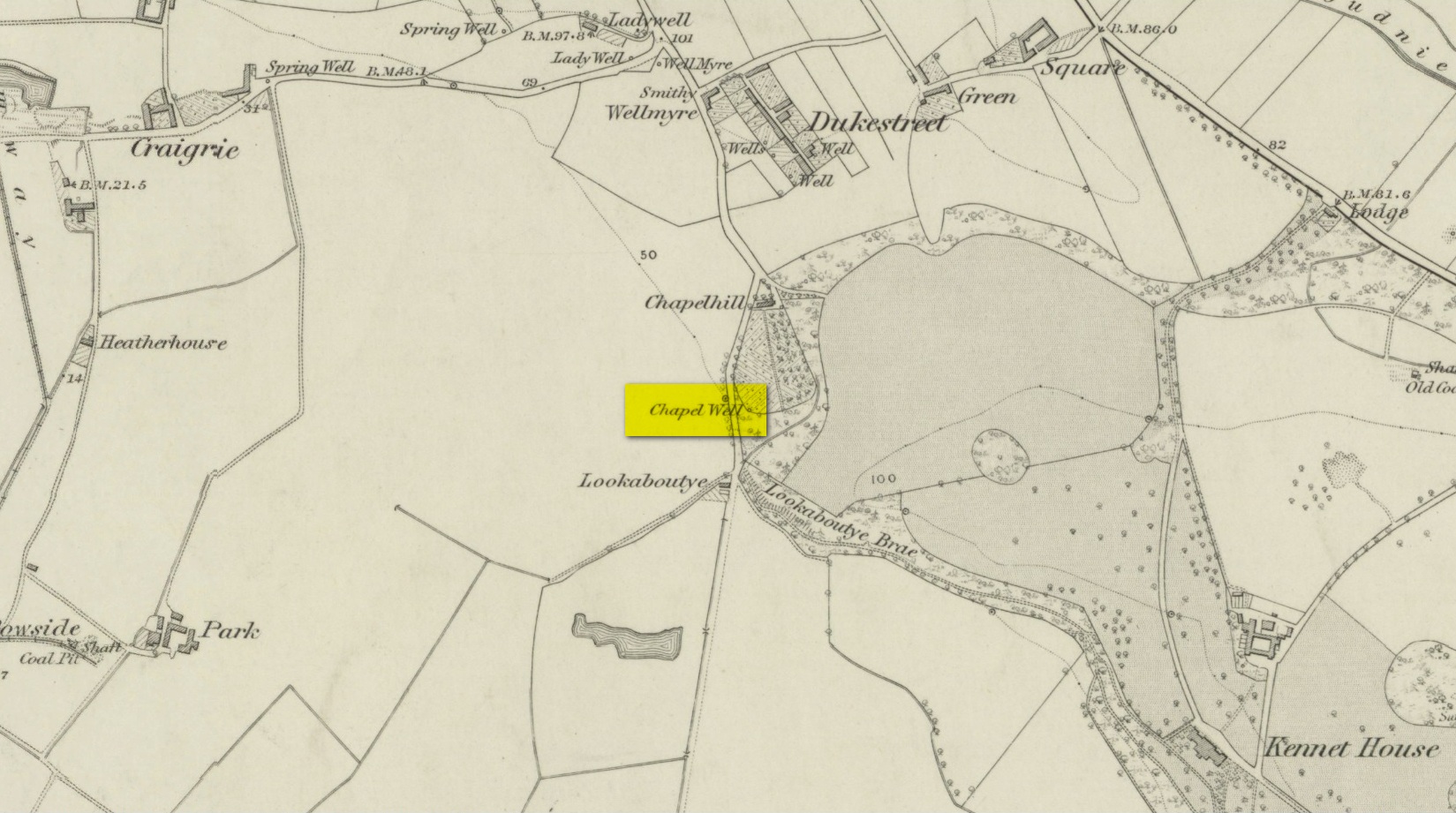
A little-known holy well on the south-side of the village has seen better days – if indeed it’s still there! Located 500 yards due south of the destroyed Lady Well, this spring of water gained it name, according to local lore, from its proximity to an ancient chapel—remains of which have been frugal to say the least! Shown on the earliest Ordnance Survey maps and continued to be shown until the 1950s, it seems that the first written account of it was in the Object Name Book of 1861 where it was told:
“A Spring well adjacent to Chapelhill. It is cut in a freestone rock, from which issues a constant supply of pure spring water even in the dryest Seasons. It is not impregnated with any Kind of Mineral. A Chapel Stood near it at one time, the site of which Cannot be pointed out by any person in the neighbourhood.”
A visit by one of the Ordnance Survey lads here in 1950 found the well to be blocked-up by silt and soil; and on a quick visit I made here today I could find no remains of the well, but it may have been beneath the mass of excessive vegetation. A subsequent visit in the winter may prove more fruitful – he sez, hopefully…..
Holy Well (destroyed): OS Grid Reference – SE 2894 3382
Archaeology & History
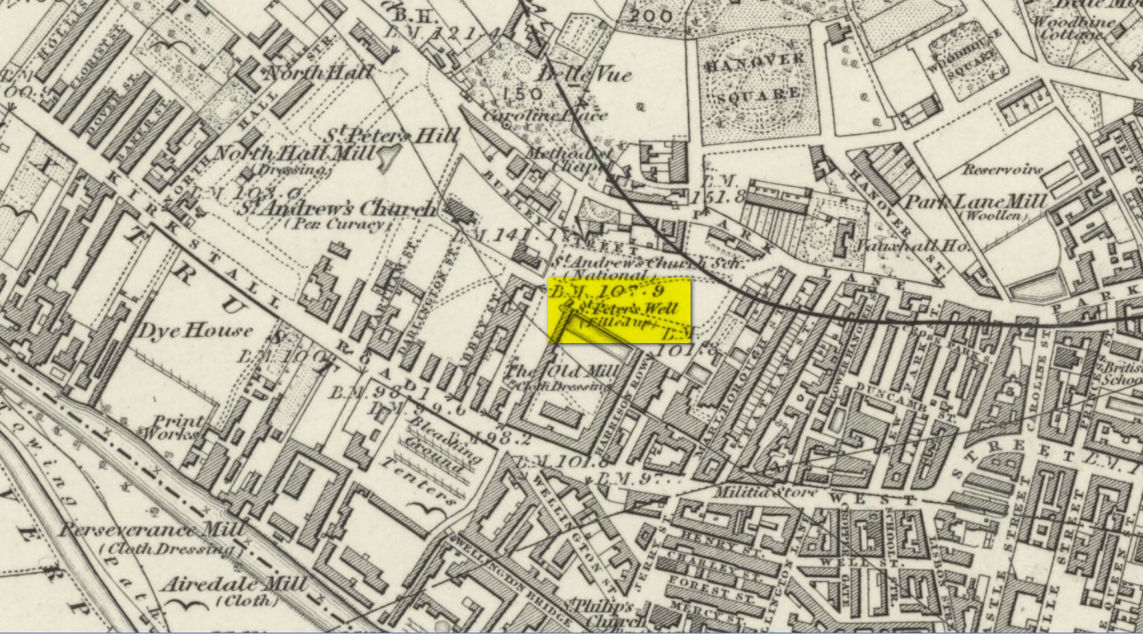
St Peters Well on 1852 map
Not to be confused with the other St. Peter’s Well that once existed in the city centre, this site was shown on an 1815 map of Leeds (which I’ve not been able to get mi hands on!), known as the Waterloo Map. But when the Ordnance Survey lads visited the place in 1846, it had been covered over. Immediately west of here, the saint’s name was also given to a nearby hill, whose folklore seems has been forgotten.
Although Ralph Thoresby mentioned it in passing, Edward Parsons (1834) gave us a brief description of its qualities, telling us that,
“Near North Hall is the celebrated spring called St. Peter’s Well ; the waters are so intensely cold that they have long been considered very efficacious in rheumatic disorders.”
Bonser (1979) reiterated this in his survey, also telling that, like its nearby namesake, its waters were “intensely cold and beneficial for rheumatism, rickets, etc.” An old bathing-house that was “annexed to the Well” may have been used specifically to treat such ailments, but we cannot say for sure.
Interestingly, Andrea Smith (1982) told that 400 metres away a well was sunk in 1838 and a quantity of petrified hazelnuts were recovered from a broken red jar which had a female head painted on it. Such a deposit is not too unusual, as a number of sacred wells in bygone days were blessed with nuts and signified the deity Callirius, known by the Romans as Silvanus, the God of the Hazel Wood – though we have no direct tradition here linking St. Peter’s Well with this ritual deposit.
St. Peter’s festival date was June 29.
References:
Bonser, K.J., “Spas, Wells and Springs of Leeds,” in The Thoresby Miscellany – volume 54, Leeds 1979.
Hope, Robert Charles, Legendary Lore of the Holy Wells of England, Elliott Stock: London 1893.
Parsons, Edward, The Civil, Ecclesiastical, Literary, Commercial and Miscellaneous History of Leeds, Halifax, Huddersfield, Bradford, Wakefield, Dewsbury, Otley – volume 1, Frederick Hobson: Leeds 1834.
Smith, Andrea, ‘Holy Wells Around Leeds, Bradford & Pontefract,’ in Wakefield Historical Journal 9, 1982.
Healing Well (lost): OS Rid Reference – NS 579 884
Archaeology & History
One-and-a-half miles east of Balfron, this curiously-named well could once be seen – and indeed may still be there. Mentioned just once in D.S. Buchanan’s (1903) Guide as a well-known place, I’ve been unable to locate it and can find no other accounts of the place. He wrote:
“A little beyond Dailfoil there is a road to the right, down which, about 200 yards, there is a stile over the fence, only a few feet from the famous Gerchew Well, on the banks of the Endrick. Here the visitor can repose for a time under the shade of the trees, and quench his thirst in its pure, cool, and bubbling waters.”
His directions seem to indicate it as being just off the small road that runs to the ruins of Easter Gerchew, but there is nothing of note hereby. A half-mile away was Wester Gerchew house, which seems contrary to his directions —and there’s nothing in evidence there either. And so I enter it here in the hope that someone might be able to relocate this healing well. (the grid reference is an approximation based on Buchanan’s description)
References:
Buchanan, D.S., Buchanan’s Popular Illustrated Guide to Strathendrick, Aberfoyle and District, J. & C. Buchanan: Balfron 1903.
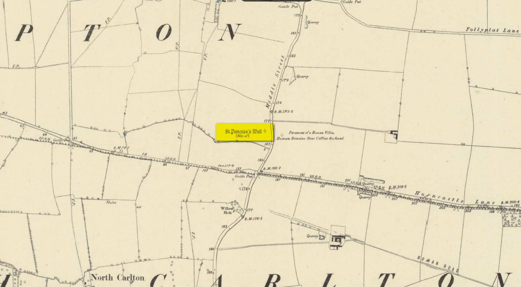
Holy Well (destroyed): OS Grid reference – SK 9542 7853
Archaeology & History
Site shown on 1886 map
Mentioned in Thompson’s (1999) survey but without comment, it was, curiously, Skyring Walters’ (1928) that drew my attention to this site. He added it to his list of St Pancras sites, telling how even in his day, it had fallen into memory. Indeed, it had already gone when the Ordnance Survey lads came here in 1885. Thankfully we were left with an albeit piecemeal account of the place by Cayley Illingworth (1810) before its destruction. It was an iron-bearing well that existed some fifty yards from an ancient Roman villa and was probably the water supply for the Romans who lived here. He told us:
“The circumstance…of the chalybeate spring within a few yards from the entrance of the villa, and still called Saint Pancras Well…favours the conclusion of a chapel having been erected on its site. (This) is supported by the strong evidence of a discovery, upon record, that a chapel dedicated to Saint Pancras did actually exist on this spot, so early as the beginning of the twelfth century; about which period Richard Fitz-Robert of Scampton gave to the monastery of Kirksted three selions of land in that lordship, two of which are described in the gift as lying in the south field, on the south side of the chapel of Saint Pancras.”
He further told that at the bottom of the well an oak floor had been laid, which had been dug up “several years ago.”
St Pancras’s festival date is April 3.
References:
Cameron, Kenneth & Insley, John, The Place-Names of Lincolnshire – volume 7, English Place-Name Society: Nottingham 2010.
Harte, Jeremy, English Holy Wells: A Sourcebook – volume 2, Heart of Albion Press: Loughborough 2008.
Illingworth, Cayley, A Topographical Account of the Parish of Scampton in the County of Lincoln, T. Cadel & W. Davies: London 1810.
Thompson, Ian, Lincolnshire Springs and Well, Bluestone: Scunthorpe 1999.
Walters, R.C. S., The Ancient Wells, Springs and Holy Wells of Gloucestershire, St Stephens Press: Bristol 1928.
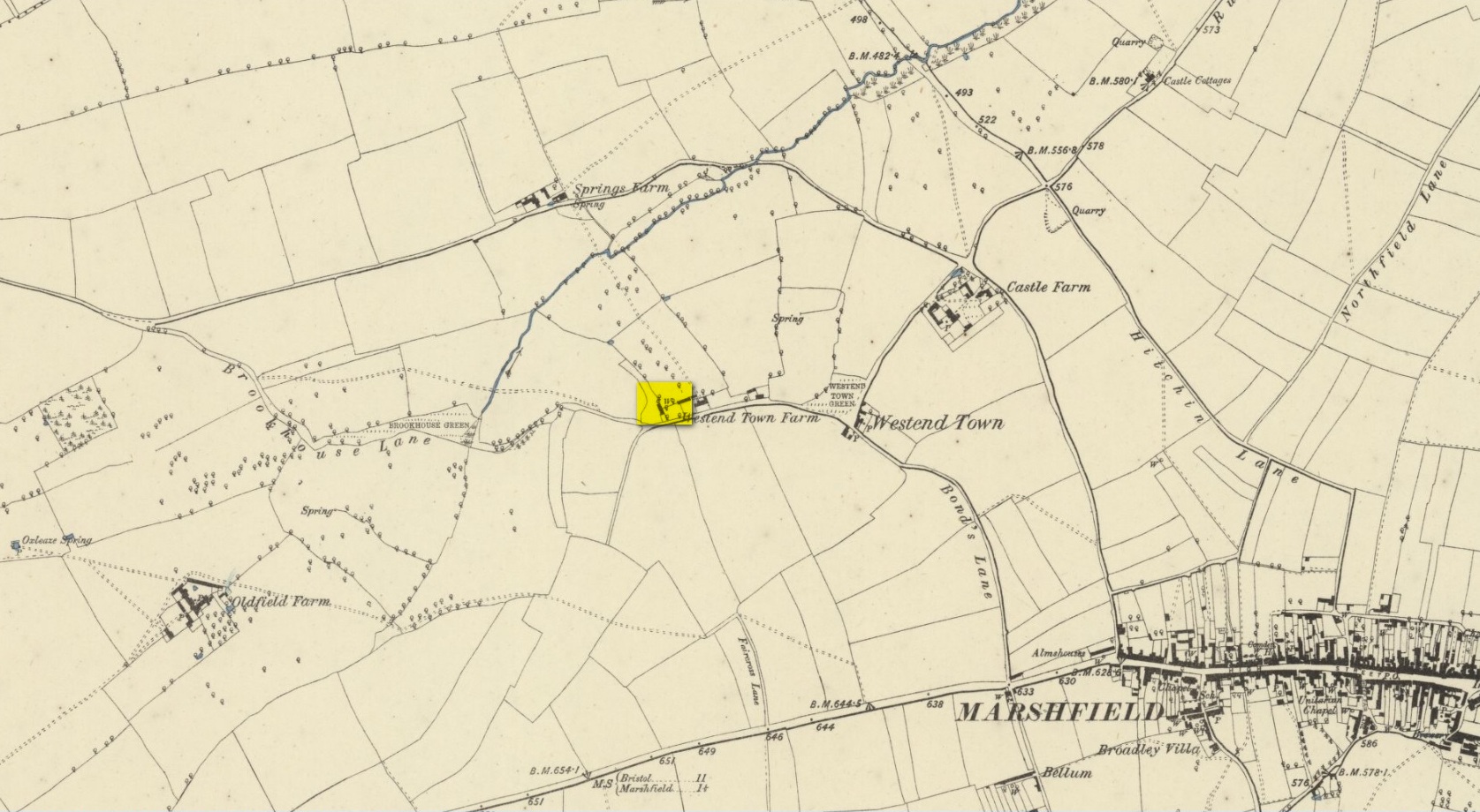
In R.C. Skyring Walker’s (1928) fine survey of Gloucestershire’s holy wells, he lamented the passing of this site, telling how
“it is sad to relate that this well has totally disappeared and its precise site is unknown.”
Since those words, the situation regarding its whereabouts has not been resolved. First mentioned in Samuel Rudder’s (1779) work, the main clue we’ve got regarding its whereabouts is his description of the adjoining hamlets and village tithes:
“Westonton, formerly called Old Marshfield, or Little Marshfield. It has been a distinct parish, called St Pancras, according to Sir Robert Atkins, and a well in this hamlet still bears the name of that saint.”
‘Well’ on 1886 OS-map
Westonton is the old farmhouse of Westend Town less than a mile northwest of Marshfield where, on early Ordnance Survey maps, a Well is shown. To the north of this is Springs Farm. This latter name probably has no bearing on St Pancras’ Well; but the location cited by Rudder of the well being in Westend Town gives us a damn good indicator as to where local historians should dig for this forgotten sacred site.
The Well was described in T.D. Fosbroke’s (1807) work, but only in passing. St Pancras’s festival date is April 3. (the grid reference cited for this well is an approximation)
References:
Fosbroke, Thomas D., Abstracts of Records and Manuscripts Respecting the County of Gloucester – volume 2, J. Harris: Cirencester 1807.
Rudder, Samuel, A New History of Gloucestershire, S. Rudder: Cirencester 1779.
Smith, A.H., The Place-Names of Gloucestershire – volume 3, Cambridge University Press 1964.
Walters, R.C. S., The Ancient Wells, Springs and Holy Wells of Gloucestershire, St Stephens Press: Bristol 1928.
Healing Well (destroyed): OS Grid Reference – SU 215 995
Archaeology & History
Not listed in the field-name surveys of the town, the name Slaughter Well was obviously a folk-name given to it by local people. The place was mentioned in an unpublished manuscript that Adin Williams’ (1888) managed to lay his hands on, where it was mentioned in relation to the missing pyramidal Market Cross. Its waters were “said to be medicinal.” The name of the well was said to derive from a battle here between Oliver Cromwell’s men and the Royalists. At this place,
“an officer was shot, and this incident gave the name ‘Slaughter’ to the well.”
References:
Williams, Adin, Lechlade: Being the History of the Town, Manor and Estates, The Priory and the Church, E.W. Savory: Cirencester 1888.
Follow the same directions as if you’re visiting the Wester Glentarken (1) carving, but some 10-15 yards before reaching it, you’ll notice this smaller rock with a series of curious naturally-eroded features on it.
Archaeology & History
This rounded stone has a series of natural deep cracks and undulating geological features on its surface, some of which look like elongated man-made cup-marks—but they’re not! The only man-made ingredient on this stone is the deep single cup-mark close to the centre of the stone, as you can see in the photo. That’s it—nowt else!
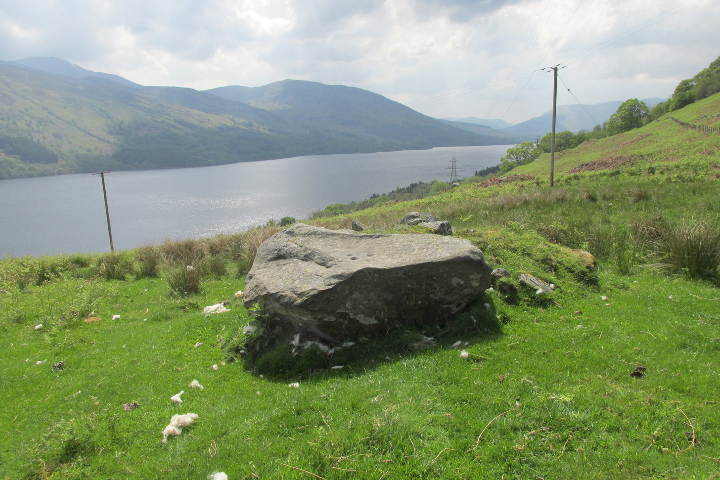
1½ miles out of St Fillans on the A85 road to Lochearnhead you’ll reach the boating marina by the lochside. A hundred yards or so past this, park up. Cross the road and walk 50 yards to your right then follow the dirt-track up into the trees. After ⅓-Mile (0.5km) turn left to the old house on your left and follow the green path around it, then around the right-side of the rocky knoll in front of you. Once you’re on the level ground around the knoll, walk forward for less than 100 yards. Y’ can’t really miss it!
Archaeology & History
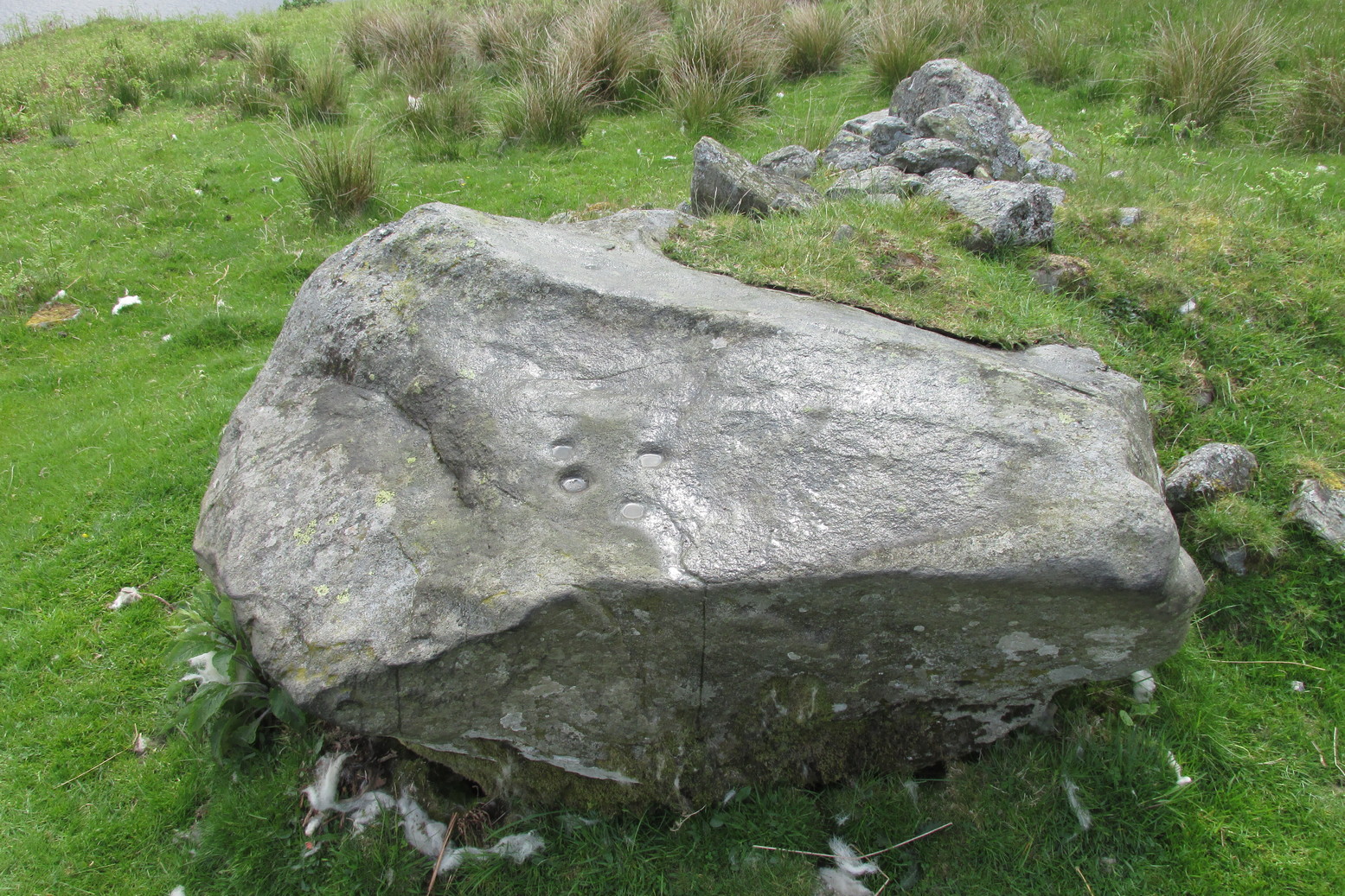
4 of the 5 main cups
A simple design, but a clear one, of four deep cup-marks which can be seen on the eastern side of the stone, with a solitary one—much more faint—just over the rise on the more western section of the rock.
There are a number of other large sections of rock around the knoll with what appear to be cup-markings of various forms, but apart from perhaps one or two exceptions, the vast majority of them—as Currie (2005) also noted—seem to be natural.
References:
Currie, George, “Wester Glentarken, Perth and Kinross (Comrie parish), cup-marked rocks,” in Discovery & Excavation Scotland, vol. 6, 2005.
Holy Well (destroyed): OS Grid Reference – NO 4026 3072
Also Known as:
Ladies Well
Our Lady’s Well
Archaeology & History
Lady Well on 1776 map
One of at least five sacred wells (see also St Francis’s Well, the Nine Wells, St Clement’s Well, St Mary’s Well and Sinavey Well) that could once be visited in Dundee: like its compatriots they have all fallen under the hammer of the Industrialists and flow no more. Our Lady’s Well could once be seen near the ancient Chapel of our Lady, “flowing from under the Chapelshade Braes,” said Maxwell (1884), its waters “bright and sparkling,” but today it has been drained and laid to rest beneath the road. Its memory however, has been preserved in the modern place-names of the Ladywell Roundabout and the nearby Ladywell Avenue.
The well was mentioned as far back as 1409 when, as Alex Lamb (1895) found, it was referred to in a contract between the Constable of Dundee and the burgesses. It flowed freely until the beginning of the 18th century when, as Maxwell told us, “the water from the Lady well was impounded and conveyed in pipes for supplying other cisterns throughout the town.” Nicoll (1923) thought there may have been a well-house built around it. Previously, the water from here was one of many springs and burns that fed the larger Castle Burn down to the sea.
The generally approved idea that Lady Wells derive from St Mary was questioned in this instance in Colville’s (1822) survey, who thought, not unreasonably, that
“As a convent stood near the same place, it is more probable that it took the name of the Ladies-well, from the fair sisterhood, who must have been the guardians of it and of all the places near them.”
He may be right. Colville also brought attention to a second water supply close by that seemed to be of equal importance in a pragmatic sense as the Lady Well herself. In danger of being destroyed, the author brought attention to it and insisted on securing its survival. He wrote:
“A little to the west, and adjoining to the Lady-well, is a large garden lying on a gentle declivity, called the Lady-well Yard,— in which there is a most abundant spring of excellent water, that was never known to fail in the driest summer, even when the Lady-well was so drained as not to afford supply to the inhabitants. Should this be employed for a steam-engine in the present prosperous state of manufactures, a pit for the water would require to be sunk, which might materially injure the Lady- well. It would certainly, therefore, be of advantage to the town, if the Magistrates could procure this property,— which would prevent the Lady- well being endangered; and the addition of this copious spring would at all seasons afford a plentiful supply of excellent water to the town.”
Holy Well (lost): OS Grid Reference – NO 401 301 (approximation)
Archaeology & History
Cited just once in the “Register of the Great Seal” (Registrum Magni Sigilli) in the year 1512 CE, this Fontis Beate Marie, or Well of St. Mary has long since disappeared. Its exact location in the city has been forgotten, but it seems likely to have been close to St. Mary’s Church. Further research is needed.