This ‘hill of the big cairn’ is near the top end of the island, past the cup-marked stones of An Carn, just beneath the top of the prominent knoll, a half-mile east of the track. It’s about 200 yards from the summit on the southern side of the hill. More than 50 feet across and about 3 feet high, what may be kerb-stones can be seen on the west-side of the tomb. The Royal Commission (1984) lads tell us that,
“its northern edge is buried under field-gathered stones, and a small enclosure of comparatively recent date overlies the cairn.”
References:
Royal Commission on the Ancient & Historical Monuments of Scotland, Argyll: volume 5 – Islay, Jura, Colonsay and Oronsay, HMSO: Edinburgh 1984.
From Durness take the road east for a couple of miles till you see the signpost which takes you on the left-hand side of the road, down to the coast. You can’t miss it!
Archaeology & History
Findings here allege to take the history of the place into the mesolithic period, but we don’t know this for sure. An excavation here by a Mr Donald Macdonald of Sangobeg in 1904 uncovered the presence of several small bone pins, which seem consistent with Mesolithic finds elsewhere. When archaeo-excavations were done here in 1982, human remains going back to at least Iron Age were found in the simple deposit of many shells. A further analysis by the Glasgow Archaeology Unit in 1996 was prevented of some excavation by (get this!) those screwy Health & Safety regulations. Here’s a definite case for an independent group to undertake work here, as we could ignore such preventative measures (and if we drown it’s our fault!). Smoo Cave’s primary function is pretty obvious: it would have been used for both shelter and ritual.
Folklore
The folklore here tells of magick and occultism and possible remnants of rites of passage lore. For herein, many centuries ago, a powerful land-owner called Lord Reay — reputed as a master in the black arts — battled with the devil in the Smoo Cave.
The devil was keeping watch on Lord Reay following a previous dispute between the two of them, and espied him as he entered the cave. As Alexander Polson told it, the cave
“consists of three caverns, one within the other. Lord Reay had got as far as the second, and his dog, which had gone on in advance, returned howling and hairless. By this, Lord Reay knew that Satan was there before him, and bravely waited the attack, which was soon made, and his lordship fought lustily. Happily at the opportune moment a cock crew. This frightened the devil and his attendant witches, but Lord Reay stood between them and the exit. In their fright they blew holes through the roof of the cave, and this is the origin of the two openings through which the Smoo burns fall.”
Pitch black cave; protective spirit animal; encountering one’s psychological nemesis; unconscious battles with Underworld forces; rebirth of the sun at cock-crowing time; the conquering of the dark forces and renewal of Lord Reay. These are typical hallmarks probably signifying folk-remnants of shamanism and rites of passage, for which this cave may once have been used.
References:
Polson, Alexander, Scottish Witchcraft Lore, W. Alexander: Inverness 1932.
Very close to being at the top of the island. If you do manage to get here take a gander at the legendary Gulf of Corryvreckan: one of the largest whirlpools on Earth, where the cailleach swirled her stuff when angry! This is the ‘hill where sorrel grows,’ and where George Orwell wrote 1984 – but more important for us is where the Royal Commission for Historic & Ancient Monuments of Scotland (Argyll, vol.5) designated that,
“a stony mound about 5.5m in diameter and 0.5m high, situated on the crest of the ridge east of Barnhill, appears to be a prehistoric burial cairn.”
Sadly I never managed to check this out when I was last up here as I didn’t know it was here!
References:
Royal Commission on the Ancient & Historical Monuments of Scotland, Argyll: volume 5 – Islay, Jura, Colonsay and Oronsay, HMSO: Edinburgh 1984.
Takes a bitta getting to this one, right at the far end of the road, leading to nowhere – so those of us who like Scotland for its vast expanses of ‘middle o’ nowhere’ should like it! From Port Ellen, travel along the A846 eastwards, all the way to the where it ends in Ardbeg. But the smaller track road continues up the coast. Keep going – and keep going all the way up; past the ‘stone circle’ of Ardilistry, past the standing stone of Trudernish, right to the very end where the track leads you to the farmhouse of Ardtalla. Once here, you’ll see the stone about 20 yards west of the farm.
Archaeology & History
This old stone is only 4-foot-tall, leaning slightly, but—as I recall from many years back—”it’s cute!” (sad aren’t I?!) All the way up here to see a small monolith! Even the Royal Commission (1984) lads didn’t have much to say about it, merely:
“This standing stone is situated 18m NW of the SW gable of Ardtalla farmhouse. Leaning slightly to the SSE, it measures 0.48m by 0.48m at the base and 1.25m in height.”
But if you like walking, the rest of the route up the coast is excellent. Stick yer tent in the small woodland by the fort a mile or two further north, then bring your attention to the legendary Beinn na Cailleach, if the heathen within you stirs…
References:
Royal Commission on the Ancient & Historical Monuments of Scotland, Argyll – volume 5: Islay, Jura, Colonsay and Oronsay, HMSO: Edinburgh 1984.
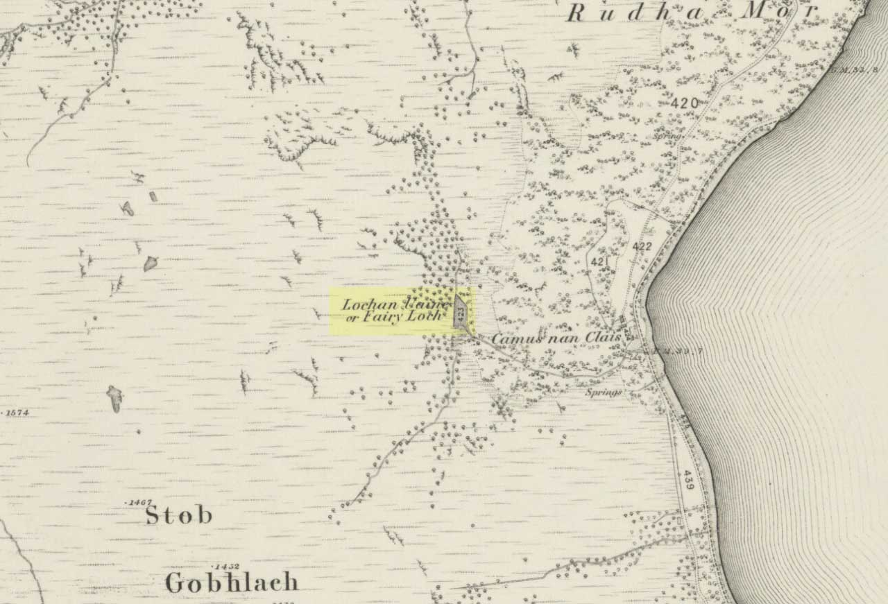
To get here, go down the A82 about four-and-a-half miles south of Tarbet (along the Loch Lomond road). Near a burn coming down the hill is an old house, long in ruin, and near the side of this is an old path – more for deer than city-folk. Go up through the wooded hillside for about a half-mile (amble the trek and make it a nice hour’s walk to get into the place). I’d take the stream itself, as you get more into the nature of the place once you get up the slope: there’s more to see, feel and a healthy water supply en route.
Folklore
This is more of a ‘holy loch’ than a holy well — for obvious reasons. Although it’s not much bigger than a large pond, it is little-known, but has long had the tradition of being an abode of the sith, or faerie-folk. There is, of course, a tendency to find prehistoric remains where the sith have their repute, but there seems little on official records nearby.
Tradition tells that the loch was actually formed in ancient times by locals damming the burn for water supply. Another tells the same in order that a mill could be fed with constant water – though no mill can be found. If this latter tradition is true however, the fairy creature here could have been a brownie – though they are generally more a lowland elemental. One of the reasons the place has been named after the little people is that when certain light falls on it, at the right time of day and year, green triangular shapes emerge from the water formed by deposits hidden beneath the surface (hence the original Gaelic name, Lochan Uaine, or the Green Loch).
Local historian Norman Douglas echoed the folktale described many years earlier by the great John Gregorson Campbell (1900), telling that,
“another story is that the local people would deposit their sheeps’ fleeces in the Fairy Loch overnight, wish for them to be dyed a certain colour, and overnight the fairies would carry out their wish.”
References:
Campbell, John G., Superstitions of the Highlands and Islands of Scotland, James MacLehose: Glasgow 1900.
From Lochgilphead go north up the A816 for just over a mile, turning left going through Cairnbaan to Bellanoch, where the road bends left up the B8025 into the trees. Keep along here for a mile and when the small road appears on your left, follow it for just over a mile till you see the cottage on the roadside with the loch at tha far end of the garden. There’s a small path besides the cottage. Walk along here for 100 yards until you see the small cairn on your left.
Archaeology & History
This is a beautiful quite place with only a small pile of stones here, about 100 yards west of Gariob Cottage on the ridge overlooking Loch Sween. The remains of the cairn here are about 20 feet across (or were when I last came here nearly 20 years ago!). Excavations here in 1977 and 1978 found a small cist split into 2 sections, just off-centre, aligned northwest. The lower part of the cist was filled with small stones and charcoal; whlst the larger section had the same with additional quartz stones in it.
References:
Royal Commission on the Ancient & Historic Monuments of Scotland, Argyll – volume 6, HMSO: Edinburgh 1988.
Cairn (destroyed): OS Grid Reference – NO 2738 4885
Archaeology & History
Unfortunately we can no longer see the large prehistoric tomb that was once visible in the fields here, close to the bottom corner of the field below the old Bridge of Ruim, a couple of hundred yards north of the A926 road to Ruthven. The site was destroyed around 1863, but records show that there were several burials found here containing human bones, along with an urn. Described in an early PSAS article, the Scottish Royal Commission chaps seemed to think that “its position may be indicated by a low swelling in the field”, about 30 yards southeast of the position shown on the first OS-map. Anyone know owt more about this place?
References:
Royal Commission on the Ancient & Historical Monuments of Scotland, North-East Perth: An Archaeological Landscape, HMSO: Edinburgh 1990.
Cairns (destroyed): OS Grid Reference – NT 2447 6828
Archaeology & History
Not far from the giant cup-marked Caiy Stone, there used to be two very large prehistoric cairns, which local historian Daviid Shankie told us “were foolishly broken up by some sacriligious hand and used for road metal”! Not good… Remains of human bones and several fragments of old weapons were found in them. Fred Coles (1903) told us that:
“In the neighbourhood of this [i.e. Morton Hall], but further southwest, on the grounds of Comiston, were found, in forming the public road, under large heaps of stones, various sepulchral stone enclosures, in which were deposited urns with dead men’s ashes, and divers warlike weapons.” And again, when speaking of the levelling of a part of the ground close to the old (so-called Roman) road, by Sir John Clerk of Pennycuick, the same writer adds, there ” were discovered several stone coffins with human bones.”
Folklore
According to Shankie (1902), these two great cairns were built upon lands previously known as the Templelands of Swanston and commemorated a great battle that was fought “between the ancient Picts and Scots.”
There’s considerable Bronze- and Iron-Age archaeology all round here (cairns, settlements, earthworks and more), but it seems that the once-proud standing stone highlighted on the 1899 Ordnance Survey map found on the higher ground a half-mile north of Middlesknowes, no longer stands where it had been standing for all those thousands of years. What, pray, has become of it…?
References:
Royal Commission on the Ancient & Historical Monuments of Scotland, Roxburghshire – volume 2, HMSO: Edinburgh 1956.
Stone Circle (destroyed): OS Grid Reference – NT 666 286
Archaeology & History
One of those site place-names with a familiar ring to it: Har, boundary; law, tumulus (though it can also be used to mean ‘a meeting place’). Nevertheless, whatever the precise origin of the name, the site here seems to have been destroyed.
Although listed by the Royal Commission in 1956 as a stone circle, John Barnatt thinks it may have been a tomb of sorts – which is what the place-name infers if we’re puritanical about it. Alexander Jeffrey (1864) told us the most, saying that:
“A field to the east of Fairnington village is called Harlaw, from a circle of large stones which stood within it, but which have been removed to serve farm purposes.”
Its exact location is unknown, though the Royal Commission lads thought it probably “stood somewhere near the present Harelaw Plantation,” about a mile east of the village. Any more info on this lost site would be most welcome!
References:
Burl, Aubrey, The Stone Circles of Britain, Ireland and Brittany, Yale University Press 2000.
Gelling, Margaret, Place-Names in the Landscape, Phoenix: London 2000.
Jeffrey, Alexander, The History and Antiquities of Roxburghshire – volume 3, Seton & MacKenzie: Edinburgh 1864.
Royal Commission on the Ancient & Historical Monuments of Scotland, Roxburghshire – volume 2, HMSO: Edinburgh 1956.