When water first emerges from the Earth they’re known as ’springs’ of water; those with stone troughs or basins into which the water falls are ‘wells.’ I don’t see much difference misself! And if water was of any importance to our ancestors (anyone who thinks it wasn’t is probably a bit slow…), such a clinical definition is of little importance. Many water-sites possessed great healing or therapeutic properties, as evidenced by chemical analyses (mainly in Victorian times, when a bittova craze on these wells was in vogue), aswell as folk-tradition, plus vast numbers of subjective encounters. To ancient societies – indeed, to myself – water is our blood, or the blood of the Earth. Treating this liquid as little more than a ‘commodity’, aswell as polluting it, should be a criminal offence – simple as!
The huge stone trough at the side of the Wycoller Beck further down than the old bridge had a pipe leading to it from a spring on the other side of the beck. Cookson & Hindle (1974) told that this was “the only source of drinking water” — which wasn’t quite true. In the old photo shown here, the groove in the supporting vertical stone once held a lid over the top of the trough, “to prevent animals, dead leaves, etc, from fouling it.” In addition to the old photo shown here, the well is also illustrated in Folley’s Romantic Wycoller (1949) with two young girls drinking the running water.
References:
Bentley, John, Portrait of Wycoller, Nelson Local History Society 1975.
Cookson, Stanley & Hindle, Herbert, Wycoller Country Park, H. Hindle: Colne 1974.
Folley, E.W., Romantic Wycoller, Coulton & Co.: Nelson 1949.
From Kelbrook village head south past Old Stone Trough then continue as far as the lane goes. Then head eastwards for about 1 mile on footpaths to a building called Laycocks. From here continue east along footpaths for another 1 mile or so until you reach Copy House (now called Hawres Farm). Go to the back of the farm where you will see in the wall a cross-incised boundary stone. At the side there is a square-shaped holy well. (You may need to ask permission at the farm).
Archaeology & History
Dissenters Well & Cross (image courtesy ‘QDanT’)
The so-called Dissenters’ Well is a rectangular feature in the ground next to the wall. It is said locally to date from the 17th-18th century, but is most probably an ancient moorland spring. The well was in use from the 17th century by Quakers, Baptists, Methodists and possibly Roman Catholics, at a time when there was much animosity towards non-Conformists. Legislation was passed stopping all illegal gatherings to be held within a 5 mile radius of any church – thus leading to religious gatherings in bleak, remote places on the moorland above towns and villages. In 1812 an Act of Parliament against non-Conformists was repealed and dissenters were given equality regarding where they could worship. The water in the well no doubt had some medicinal qualities or, was a source of spiritual up-lift at the time.
By the well there is 3 foot high pointed boundary stone or waymarker known as ‘Tom’s Cross’ and it has a thin incised cross carved onto it. The stone is partly embedded in the wall. It probably marks the old boundary between Lancashire and Yorkshire. I don’t know who Tom was though he may have been the person who set up the stone. The age of the stone is not known.
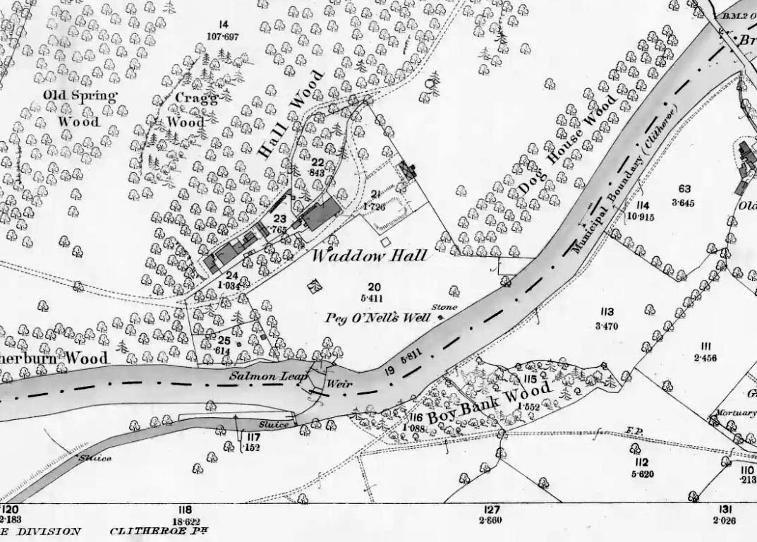
The well is located in the grounds of Waddow Hall close by Brungerley Bridge, near Waddington, in the Ribble Valley. The hall is just off the B 6478 road about three-quarters of a mile south-east of Waddington village. It is on private land, but you can see the well by walking along a footpath at the western side of the hall running along the banks of the River Ribble at the southern side of the hall grounds.
Folklore
The legend originates from the 18th century although the well is a pre-Christian spring. According to this most often told ‘legend’ Peg O’ Nell was a servant girl at Waddow Hall. However, she often fell out with her masters, the Starkie family, often quarreling with and being disobedient to them. One night, in particular, Peg had a blazing row with Mistress Starkie after saying she didn’t want to fetch water from the well; the mistress was so enraged that she shouted at the servant saying “I hope you fall and break your neck”. At a later date this came true when on a particularly icy night Peg went to fetch water from the well, but on her way there she slipped on some ice and fell into the River Ribble, at a treacherous spot, and did indeed break her neck. From that time on there seems to have been a curse on the Starkie family – anything and everything that happened at the hall was blamed on Peg, or her ghost, which was now haunting the house and grounds. Mistress Starkie became so fed up with the curse that she took an axe and chopped off the head of a statue that had earlier been placed beside the well in memory of poor Peg. Thinking that by doing this the curse would come to an end, and it seems to have done just that, because afterwards peace and quiet seems to have come upon the hall.
Peg o’ Nells Well on 1884 map
Another legend or tale says that Peg dwelt by the well, perhaps as a kind of sprite, but that she caused a local Puritan preacher to fall into the River Ribble. As a punishment for this dastardly trick the head of the statue was chopped off. Folklore says that a water spirit or “sprite” lived in the well which was connected underground to the nearby River Ribble.
But the truth about this seems to be that the headless statue is that of St Margaret of Antioch who was beheaded for her faith in the early centuries of Roman rule. St Margaret’s feast day was on 20th July. Apparently, her statue was brought to Waddow Hall from either Sawley Abbey or Whalley Abbey where it had stood in its own niche, or possibly it came from a local Catholic church. The headless statue appears to be holding a bible in one hand; so it was probably placed at the side of the well in order to make the well holy and sacred to pilgrims who used to visit the site for healing purposes on the saint’s day. The head of the statue used to reside in an upstairs room at the hall, but it was lost for a time, only to be re-discovered and embedded into a wall at Brungerley farm not far from the bridge.
But we may never know what really did happen here because legend and folklore have become mixed in with other tales that may, or may not, be true. The holy well stands in a meadow in the hall grounds and is a square-shaped hollow in the ground where water still flows, possibly fed by the river close by. The statue still stands at the side; and fencing now surrounds this sacred site. The hall and grounds are still said to be haunted by a ghost, but whether it is Peg’s ghost we do not know, because this particular ghost is said to be hooded ? The curse itself used to claim a victim once every seven years; the screaming spirit of Peg would rise up from the murky waters of the river on stormy nights – an animal could apparently suffice as a victim, rather than a human. This story was almost certainly made-up probably to frighten the Starkie family who it was originally aimed at.
Waddow Hall is now a Training and Activity Centre, but it used to be a Centre for girl guides and during the second world war it was an isolation hospital.
The well can be reached along a narrow country lane to the east of the A6 road, some 3-4 miles north of Preston. Fernyhalgh is a tiny hamlet between the villages of Broughton and Grimsargh with pleasent countryside on all sides. The holy well of Our Lady is in the garden of a house with a Roman Catholic chapel and pilgrimage centre at the side of a secluded country lane; entrance through a little gate.
Archaeology & History
Our Ladys Well, Fernyhalgh
There was a chapel on this site way back in 1348, and the spring itself is obviously a pre-Christian one with its dedication to Our Lady – St Mary the Virgin. According to the legend, in about 1471 a merchant sailing across the Irish sea was caught in a terrible storm; afraid that he was going to drown he prayed to the Virgin Mary and vowed that if his life was saved he would undertake some work of devotion to her. Soon the storm cleared and he found himself washed-up but safe on the Lancashire coast but he himself had no idea where he was. At that moment a heavenly voice spoke to him and told him to find a place called Fernyhalgh and there build a chapel at a spot where a crab-apple tree grew – the fruit of which had no cores, and where a spring would be found. He began to search around for this sacred place but no matter how much he tried he could not find the place.
The merchant found lodgings in Preston and, was about to give up altogether, when he overheard a serving girl at the inn. She started to explain why she was so late on arrival. She went on to say that she had had to chase her stray cow all the way to Fernyhalgh. He asked her if she could take him to this place. In a short time he discovered the apple tree with fruit bearing no cores and beneath it a spring and also a lost statue of the Virgin and child. The merchant began to build a chapel close by in memory of Our Lady and soon pilgrims were visiting the holy well and receiving miracles of healing. However, during the time of persecution from the reign of King Henry VIII and through to the reign of King Edward VI the well was abandoned and left derelict; the chapel itself was demolished.
The holy well of Our Lady was fully restored in the late 17th century and a new chapel was built in 1685 when persecutions towards Catholics had eased. Again, the place became a place of pilgrimage and many miraculous cures were being recorded there; the chapel (which is now built onto a house) being used by religious sisters as a place of retreat. Today it is a renowned Roman Catholic pilgrimage centre with thousands of visitors coming from far and wide. The holy well stands within a rectangular enclosure with steps descending down; the well itself being a small-square shaped basin overlooked by a niche inside which stands the Virgin Mary holding baby Jesus. It is very well cared for by the Catholic community with flowers usually adorning the site during the Summer months. Coins are often thrown into the well, though it is not regarded as a “wishing well”. Visitors are always welcome and, you don’t have to be a Catholic, everybody regardless of what persuasion you are can visit the well.
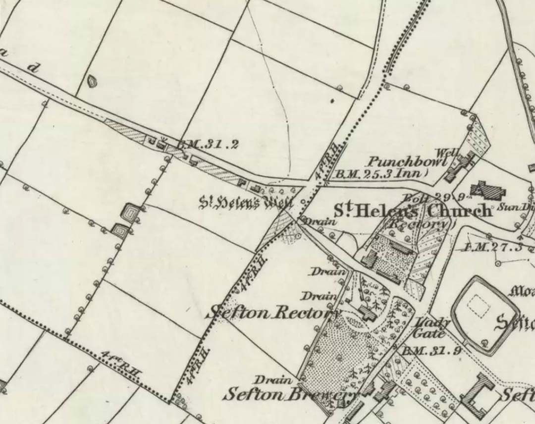
It is best to start at the Punch Bowl Inn car park, Sefton, then travel a short distance along Lunt Road by St Helen’s church. A footpath/lane is reached where a barrier stands and about 10 metres opposite the main road beneath the undergrowth is St. Helen’s holy well, or what remains of it.
Archaeology & History
St Helen’s Well on 1850 map
The well is now, sadly, capped off with an inscribed stone that recalls ST HELEN’S WELL. The well originally stood inside a rather nice little wellhouse with a pyramid-shaped, overlapping roof, with railings running around it. It was renowned for its icy waters which were especially good for people suffering from rheumatism, sprains, bruising and, also nervous problems. It had a hand pump at the side of the well-house to enable people to drink the water. But all this has now gone, though the church congregation still visit the site on the saint’s feast day and are still hoping that some day the well will be restored again.
It was probably a pre-Christian spring that in the Middle Ages turned into a pilgrimage site, especially so in the 14th century when the church was built close by.
Folklore
In pre-Reformation times it was much in use, but later on and in more recent times it had become a wishing well; pins were thrown into the well by young folk. Apparently, if the pin could be seen at the bottom of the well a favourable outcome was likely with regard to good luck in a forthcoming marriage by a couple much in love.
Addenda:
To complement Ray’s entry, here are Mr Taylor’s notes from his Ancient Crosses and Holy Wells (1906), in which he wrote the following:
“This celebrated spring rises at a distance of three hundred yards in a westerly direction from Sefton Church. In the year 1891 the well was walled round, and a handsome canopy placed over it, from the designs of Mr John Douglas, at the cost of William Philip, fourth earl of Sefton. The traditions connected with this holy well are thus graphically summed up in the History of Sefton:-
“”We must not omit to mention St Helen’s Well, which springs near the first cottage in the Thornton Road, beyond the inn. Formerly a ‘pad-road’ only led from the well to the church, the Thornton Road passing through the Rectory grounds. In the Churchwarden’s accounts we find several items of expenditure incurred for the keeping in order of St Helen’s Well. Thus we read in 1758: ‘For a new Dish and Chain for S. Ellen’s Well, 2/-.’ Ashcroft [writing about the year 1819] tells us ‘that this well was once in great repute for curing rheumatism, strains, bruises and weaknesses of the nerves. It has no mineral quality, however, and he remarks that its principal virtue seems to have been its coldness.’ In different times great respect was paid to wells ’eminent for curing distempers upon the Saint’s Day whose name the well bore,’ and it was once the custom to decorate the wells of Holy Thursday with boughs of trees, garlands of flowers, etc, places in various devices, and after service in the church the parson and singers repaired to the well, where they sang psalms and prayed. The bottom of the well, which is of no great depth and very clear, may generally be strewn with pins which are dropped in by superstitious young country folks to denote to them the probability of their marriage, which is said to be near if the pin falls pointing towards the church. Pins and pebbles were often dropped into wells, and the circles formed thereby on the surface of the water (or the question whether the water was troubled at all) were used as omens by which the observers drew inferences of future events. Mr Hampson, in his Medii Ævi Kalendarium, says: ‘I have frequently seen the bottom of S. Helen’s Well, near Sefton, Lancashire, almost covered with pins, which I suppose must have been thrown in for like purposes.'”
“…Mr Gregson wrote: ‘With regard to the curious frequency of well dedication to S. Helen, I formed a theory many years ago that the S. Helen of the county of Lancaster is not unconnected with the Celtic S. Elian, who is a frequent patron saint of wells in North Wales. Do they not both draw a common ancestry from Ella, the water sprite?'”
References:
Caroe, W.D. & Gordon, E.J.A., Sefton: A Descriptive and Historical Account, Longmans Green: London 1893.
Taylor, Henry, The Ancient Crosses and Holy Wells of Lancashire, Sherratt & Hughes: Manchester 1906.
Take the Oakworth Road outta Keighley, turning right after a quarter-mile up Fell Lane. Go all the way up the very end (a mile or so), turning right at the end. After 100 yards or so, go up the track to the True Well Hall equestrian centre. As you approach the farmhouse, look on the grassy slope to the left and you’ll see a small run-down stone structure in the field above you. That’s it!
Archaeology & History
This is a curious site by virtue of so little being said of it, despite some modern proclamations of it having pagan values. Even the local historians say little on the place, with William Keighley (1858) being our notable exception. In his notes on the erroneous dedication of the Jennet’s Well to a fictitious saint of the same name, he mentions this once important water supply, writing:
“Westwards of Jennet’s Well there was another fountain, emphatically styled the ‘true well’, and probably from its once boasted efficacy intended as a rival to the former. This spring though no longer remembered for its healing qualities, evidently gave name to the farmhouse denominated ‘True Well Hole.'”
In Wright’s Dialect Dictionary (1898) we find the word ‘trew’ — also written as ‘true’ or ‘trow’ — could mean “to trust, believe, feel sure”, which may be applicable in terms of the value of the waters that once flowed here. We may never know. Though note should be made of the error at a recent exhibition in Cliffe Castle museum, where the 1842 Tithe Awards map of the region was copied and the field-names listed, showing the old True Well erroneously displayed as the ‘Time Well’. I assume they must have had a long day when they were copying the notes…!
Spring behind True Well Hall
A little further along the track running beyond True Well Farm we find another spring of water emerging from the grassy hill and which, perhaps, relates to the True Well. On the 1852 OS-map, we see a ‘trough’ shown in front of the farmhouse and not in the position where the modern map shows the True Well to be — and where the recent stone-worked trough in the photo is shown. In fact, on the 1852 map, no such well nor stonework is shown in the position presently deemed to be where the True Well is supposed to be, so the original position of the well is unclear. Is it possible that the spring of water which runs from the hillside behind True Well Farm may have been the site which gave this spot its name. Certainly the water from this spring is quite fresh and drinkable. If anyone knows owt more about the history of this curious site, it would be good to hear from you.
References:
Keighley, William, Keighley Past and Present, Arthur Hall: London 1858.
Found to the southwest edge of Hildenley Wood, on the west side of the track between Malton and Coneythorpe Road, the waters from the initial source of the well runs into a small well-house, and from here Nature’s blood runs into a small pool. The first reference I’ve found of the place is in T. Whellan’s (1859) huge survey, where he said,
“There is on the verge of Easthorpe Wood a copious and pure spring of water known by the name of Holy Well, which tradition affirms to have been much resorted to by the monks of Kirkham Abbey…and even to this day healing virtues are attributed to it.”
In Whelan & Taylor’s (1989) survey of the site, they noted the existence of another well a short distance away, but did “not know of any sacred associations connected with this site, but its proximity to the Holy Well may suggest the recognition of this area as a sacred spot.”
In the old Hundred of West Derby in what was once Lancashire (them there political types shifting boundaries for their own greasy deeds) still remains to this day the trickling remains of old Oswald’s sacred spring, close to the Hermitage Green, which is thought to have gained its named after just such a hermit living hereby and who, no doubt, frequented or looked after this holy well for both refreshment and spiritual sustenance.
Named after the once-pagan King of Northumbria — who was later patronized and regressed to the cultus of a saint — the well was said to be close to an ancient palace, which was later moved when the King regressed into christendom. The well itself was said to have been created through the tradition that the very Earth here possessed healing powers so renowned that people came from many miles to collect and take it for its sacred and medicinal qualities. In Henry Taylor’s (1906) magnum opus he told:
“A writer in The Antiquary twenty years ago (vol.3, p.261) described it as having a very modest appearance for so famous a spot, looking merely like a hole into the hillside. The writer goes on to say, “Passing through a small cottage garden, a well-trodden path leads to the well, which is merely a fosse, as described by Bede, and, situated as it is at the bottom of a tolerable declivity, derives its supply from the drainage of the upper ground rather than from any spring. The water is not very bright, but the well is substantially walled inside, and two or three deeply worn steps lead to the water.”
“The Venerable Bede gives an account of numerous miracles which took place at St. Oswald’s Well. He says: “After which period Oswald was killed in a great battle by the same Pagan nation and Pagan King of the Mercians who had slain his predecessor Edwin at a place called in the English tongue Maserfield in the 38th year of his age on the 5th day of the month of August. How great his faith was towards God, and how remarkable his devotion, has been made evident by miracles since his death; for in the place where he was killed by the pagans…infirm men and cattle are healed to this day. Whereupon many took up the very dust of the place where his body fell, and putting it into water did much good with it to their friends who were sick. This custom came so much into use, that the earth being carried away by degrees, there remained a hole as deep as the height of a man… Many miracles are said to have been wrought in that place, or with the earth carried from thence; but we have thought it sufficient to mention two, which we heard from our ancestors.””
References:
Taylor, Henry, The Ancient Crosses and Holy Wells of Lancashire, Sherratt & Hughes: Manchester 1906.
Recently a good turn of fortune has brought about the discovery of a number of previously unpublished manuscripts detailing a number of prehistoric remains, holy wells and old stone crosses that existed in and around east Lancashire, Burnley, Cliviger and Todmorden. Many of these papers are the all-but-lost writings of historian and antiquarian Clifford Byrne of Nelson. Having never previously been published, I think his works deserve greater attention and so I’ll be slowly, gradually, sticking them on the internet and give them the wider audience they deserve. Not all of his notions are necessarily accurate, but the extent of this mans local history knowledge on the sites he describes in his essays is considerable. The following is his short essay—with minimal editing—on this all-but-forgotten site:
“Shorey Well, or rather its stone housing, was originally situated in the bank of the River Brun slightly upstream of the parish church at Burnley, at a spot now within the grounds of the Burnley Technical College. From within the stone housing issued the spring proper, which then ran down the brookside into the river.
“From time immemorial until the late 19th century, Shorey Well supplied part of the town of Burnley with its drinking water, then the water was impounded into a pipe and the stone housing removed to a place of safety. This housing was thought by our Victorian forebears to have sufficient merit to save it for posterity, and this act I feel implies more than a certain interest in the old stones which I suggest the movers of the Well probably did not themselves fully understand, and it is with this concept that I hope now to deal.
“The present location of the stones of Shorey Well is in the little triangle of greenery outside Prestige Ltd at Burnley. This spot is bounded on Colne Road and Bank Parade. Behind it squats the base of Burnley Market Cross and the remains of the stocks with — a little to one side — the shaft of the Godley Lane Cross standing out of a huge square pedestal.
“An old map in Burnley Library shows Shorey Well in situ with a well-defined row of stepping stones crossing the river directly in front. This line of stones went to the site of a still existing property called Shorey Fold — a spot that was probably once called St. Audry’s Fold, as we shall see.
“Godly Lane Cross is an Anglo-Saxon monolith with a somewhat damaged head. This damage was probably done around the time of the Reformation in the 16th century, when the anti-Catholic movement was at its height. The name Godly implies a god-like, or god-inspired or religious tone to the area, and Godly Lane — now Ormerod Road — certainly lived up to its name for there stood the parish church, the Cross itself, the Market Cross, another cross dedicated to a priest in the 16th century and now standing in the rear of Townley Hall, “Foldy’s Cross”, with nearby Shorey Well.
“There is a strong possibility that the Godly Lane Cross — sometimes called the Paulinus Cross — was a preaching cross and that it also marked the way to Shorey Well which issued close by.
“No one to the knowledge of the writer has attempted to explain the name Shorey Well. I therefore suggest that the Well was used for baptism and that it was dedicated to St. Audry. The parish church was erected prior to the Reformation and thus certainly had its Holy Well close by, from which the priests obtained water for baptism and blessings, etc. Because of its propitious nature and close proximity to the church, such a Well would almost certainly have been the Shorey Spring.
“A study of the name may be fruitful. Holy wells are almost always dedicated to some christian saint. However, many of them have undergone a slight change in name over the centuries, so that it is not always easy to recognise the dedication. For instance, the Ransible Well near Colne was dedicated to Our Lady of Ransome, or the Virgin Mary; Stellern Well was dedicated to St. Helen; Maudlin Well near Lathom House was dedicated to St. Mary Magdalen; Pewter Well at Sabden would be St. Peter’s Well; Mattus Well at Sawley Abbey is St. Matthew’s Well; whilst Cooks Well at Colne was surely dedicated to St. Luke the physician. Thus Shorey Well in the same context is almost certainly dedicated to St. Audry, and this saint we find was one of the most revered saints in Anglo-Saxon times, from which date the Godly Lane Cross stems.
“The close proximity of church, well and cross surely imply that one showed the way to the other, and that all three were at one period of time one unit: the Cross being a preaching place prior to the Church, and the holy well being a place of baptism and healing.”
Mr Byrne’s etymological reasoning may or may not be right here (Mr Ekwall says nothing in his place-name survey and I’m unaware of local dialect analysis that may account for the word), but the description of this and numerous other lost and forgotten sites in his various papers is hugely worthwhile and is a source of considerable study for us over the coming months.
Ormerod (1906) described the site in his tome, but even in his day this once great well with its “abundance of sparkling water” was “disused and neglected.” (the image above is taken from his work) However, as if to dispel any notions of an earlier saintly dedication, we find that in Walter Bennett’s (1948) magnum opus, the site had a more prosaic title in bygone years:
“Whittaker’s Well, or Shorey Well as it was later known, was situated on the riverbank opposite Dawson Square, and was apparently the only public source of drinking water for the inhabitants of tge Top o’ th’ Town.”
References:
Bennett, Walter, The History of Burnley – volume 3, Burnley Corporation 1948.
Byrne, Clifford H., “A Short Study of Shorey Well, Burnley,” unpublished manuscript 1976.
Said by John Allan (1907) to be “at the base of the Brandy Hill, about 210 yards west from the parish church,” to get to it from the town centre Stirling Arcade, go across and along the Corn Exchange Road and as it goes down the slope, take the path that leads into the trees on your right-hand side. Follow this path along to the bottom of the woods. Once on the level at the bottom, walk on the path in the direction of Stirling Castle and eventually you’ll reach the fancy walling with the dried-up well right in front of you!
Archaeology & History
This much-neglected site got its name from there being a number of archery shooting targets, or butts, which used to be erected in the fields immediately below this once popular drinking spot. Although the Stirling historian J.S. Fleming (1898) could find no definitive records of the place as a holy or healing well, he told how,
“The copious spring arising in the centre of the rock on which Stirling Town and Castle are built, must have been extensively used during the Royal occupation of the Castle for watering the horses engaged in hunting in the Park…and it must also have been the source from whence the canal or ornamental waters and fountains in the ancient pleasure-grounds of the King’s Knot were supplied, the fall being amply sufficient for the rise to a considerable height of the latter… The Well had at one time a railing surroundings its then open trough, the marks of the lead used in grouting the rails remaining visible until the last alteration.”
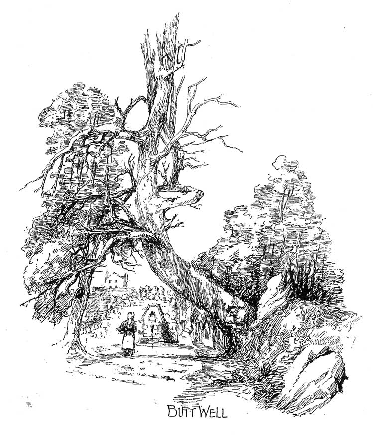
The waters emerging in the field belowThe Butt Well
Early accounts of the Butt Well are few and far between. Ronald James (1899) found it to have been known in earlier centuries as the Spout Well in 1582, but additional descriptions of the place are scant. The well is not included in the surveys of either MacKinlay (1893) nor the Morris’ (1981), though John Allan (1907) thinks that this site was a “congenial retreat” where “the bard of the chief” would gain insight. The remains of walling behind the old well he thought may have been the ancient remains of an old hermitage of sorts, but there’s little evidence to prove this. Today, although dried-up, the site appears much it as did when Fleming described it:
“The Well has had the old wall — formed of granite boulders — rebuilt and cemented, and a rustic ornamental freestone front put on where the spout is inserted, but its stone seat for invalids and other surroundings remains as they were forty years ago. The Well formed the termination of the early morning walk of the town’s folk for a draught of its cold water, and was at a late period used by the wives and washerwomen of Stirling for washing their clothes, which were then bleached on the green sward lying below the Well, the tenant of the park making a charge according to the extent of the washing.”
If you go behind the walling here you’ll notice a small flow of water which emerges into the field below. The waters from here, although only a trickle, are still cold, fine and refreshing.
References:
Allan, John, The Days of the Monasteries and Latter Days of Stirling, Stirling 1907.
Fleming, J.S., Old Nooks of Stirling, Delineated and Described, Munro & Jamieson: Stirling 1898.
Ronald, James, Landmarks of Old Stirling, Eneas MacKay: Stirling 1899.