Simon’s Seat, Skyreholme, North Yorkshire

Sacred Hill:  OS Grid Reference – SE 0788 5981

Getting Here

Simon’s Seat in the centre & the Lord’s Seat immediately east

Tons of ways here.   To those who drive, take the Grassington-Pateley Bridge (B6265) road and a couple of miles past the village of Hebden, you’ll see the high rocks climbing on your southern horizon, with another group of rocks a few hundred yards along the same ridge.  That’s it!

Archaeology & History

This is an awesome site, full of raw power. It commands a brilliant view all round, but it is the north which truly draws the eye’s attention. Beneath the great drop of this huge outcrop is the haunted and legendary Troller’s Ghyll. The scent of as yet undisclosed neolithic and Bronze Age sites purrs from the moors all round you and there can be little doubt that this was a place of important magick in ancient days.

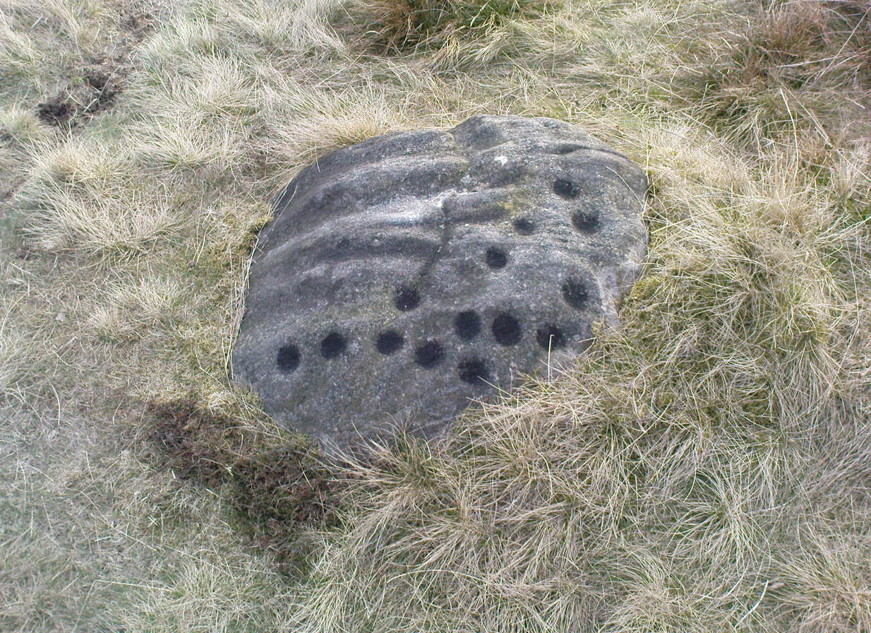
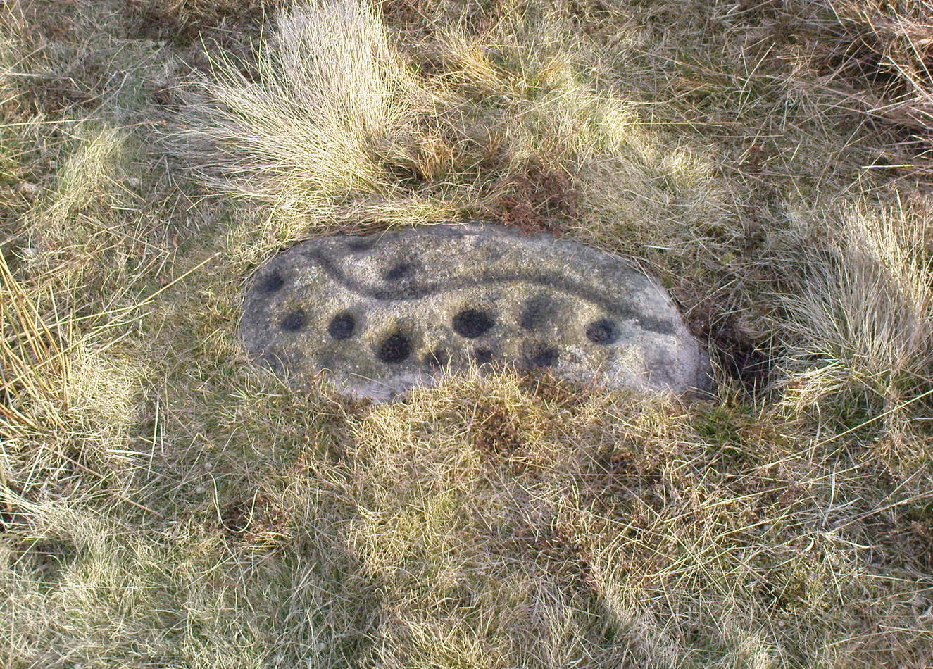
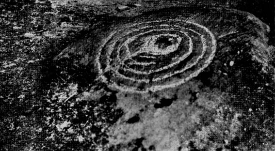
What seems to be several cup-markings on one of the topmost rocks are, to me, authentic. Harry Speight mentioned them in his 1892 work on the Craven and Northwest Yorkshire Highlands – but there are a number of other rocks in this giant outcrop with “possibles” on them.

Folklore

The name of this great rock outcrop has long been a puzzle to historians and place-name experts.  One tale that was told of Simon’s Seat to the travelling pen of one Frederic Montagu in 1838, told that,

“It was upon the top of this mountain that an infant was found by a shepherd, who took it to his home, and after feeding and clothing it, he had the child named Simon; being himself but a poor man, he was unable to maintain the foundling, when it was ultimately agreed to by the shepherds, that the child should be kept “amang ’em.”  The child was called Simon Amangham and the descendants of this child are now living in Wharfedale.”

The usually sober pen of Mr Speight thinks this to have been one the high places of druidic worship, named after the legendary Simon Druid. “It is however, hardly likely,” he wrote, “that he ever sat there himself, but was probably represented by some druidical soothsayer on whom his mystic gifts descended.”

I’ve gotta say, I think there’s something distinctly true about those lines. Visit this place a few times, alone, during the week, or at night – when there’s no tourists about – and tell me it isn’t…

References:

  1. Bogg, Edmund, Higher Wharfeland, James Miles: Leeds 1904.
  2. Montagu, Frederic, Gleanings in Craven, Simpkin Marshall: London 1838.
  3. Speight, Harry, The Craven and Northwest Yorkshire Highlands, Elliott Stock: London 1892.

© Paul Bennett, The Northern Antiquarian


Middleton Moor Carving (454), North Yorkshire

Cup-Marked Stone:  OS Grid Reference – SE 10980 51284

Archaeology & History

Carving no. 454

About 10 yards north of the old boundary stone on the Middle Ridge heading to the western end of Dryas Dike and about 10-15 yards east of the Middleton 453 carving, is this small rounded rock with between 12 and 15 cup-markings on its north and north-eastern sides.  Several curious deep ridges run down across the rock which some ascribe as being man-made – but to me they’re Nature’s fine handiwork, although I may be wrong…

References:

  1. Boughey, Keith & Vickerman, E.A., Prehistoric Rock Art of the West Riding, WYAS 2003.

© Paul BennettThe Northern Antiquarian

Middleton Moor Carving (453), North Yorkshire

Cup-and-Line Stone:  OS Grid Reference – SE 10968 51279

Archaeology & History

Carving no. 453

Named boringly after the catalogue number given it in Boughey & Vickerman’s (2003) survey, this is another of the many small cup-marked stones clustered at the western end of the ridge between Delves Beck and Dryas Dike, below the moorland slope up to the Old Pike and Beamsley Beacon.  It’s one of the more impressive of the carvings in this locale, albeit when it’s highlighted, as in the photos shown here (apparently done by one of the photographers in the Ilkley rock art group, I was told).  It’s perhaps better seen when the sun is low and the stone’s been wet, which shows the shallow undulations of the cup-marks and wavy line that seems to split the main group of twelve cup-marks  at the top northern side of the stone, from the two on its south side.  There seems to be another wavy line carved above the main cluster, but this is difficult to make out.

References:

  1. Boughey, Keith & Vickerman, E.A., Prehistoric Rock Art of the West Riding, WYAS 2003.

© Paul BennettThe Northern Antiquarian

Middleton Moor Carving (440), North Yorkshire

Cup-Marked Stone:  OS Grid Reference – SE 10875 51390

Getting Here

Middleton Moor CR-440

From the old T-junction in the hamlet of Langbar (where some doods have stuck up one of those ‘Private Road’ signs, typical of those Southern-types who bring their weird private land notions up here), go along the ‘private road’, keeping to the left until the road runs out. Then follow the small footpath above the house onto the moor, following the lines of walling along, crossing boggy streams, up the small hill and, once over the top and dropping down, keep your eyes peeled for the large boulder to the left of footpath, and a small scattered cairn on your right.  It just a few yards past the cairn material!

Archaeology & History

Just 20-30 yards up the slope on the north side of Dryas Dike stream, to the left of the footpath, is a small, rounded flat stone with perhaps as many as eight cup-markings on it.   Six seems more believable — though some of ’em on here (if not all) don’t look to have the air of authenticity that some of the other carvings hereabouts possess.  One of the cups has a small ‘tail’ protruding from it.  It’s a rather cute little thing!  A small, unexcavated cairn lies in ruin about 10 yards east of the crude carving.

…and from another angle

On the other side of the footpath from here is that “large boulder” I mentioned above, which is reported by Boughey & Vickerman (2003) to have “one clear cup” marking etched upon it.  They also report that archaeologists from “English Heritage report two cups and a possible short groove” on this rock. However none of the carvings reported here by either authority are man-made.  All marks on the rock are completely natural and it needs omitting from any future archaeological survey.

References:

  1. Boughey, Keith & Vickerman, E.A., Prehistoric Rock Art of the West Riding, WYAS 2003.

© Paul Bennett, The Northern Antiquarian


Middleton Moor Carving (003), North Yorkshire

Cup-and-Ring Stone:  OS Grid Reference – SE 11288 51542

Getting Here

In the middle of the moors, with no footpaths close by.  Unless you’re a rock-art freak I guess there aint gonna be too many people searching for it!  From the Ilkley-to-Langbar road, take the track (Parks Lane) onto the moor where the road bends right.  Follow it up for about a mile (though it doesn’t seem that far) and where the cup-marked stone at the edge of the wall where the spring appears (Middleton Moor carving 483), walk west (left) into the heather for a coupla hundred yards below Foldshaw Ridge.  Look around!

Archaeology & History

Little-known cup-marked stone on Middleton Moor (photo courtesy Richard Stroud)
Cup-marked stone, Middleton Moor (photo © Richard Stroud)

This is one of a small cluster of carvings Richard Stroud found on a few average-sized stones prettty close to each other in April 2005 — and one which the West Yorkshire Archaeology Service told him couldn’t be there cos the region had already been surveyed.  Hmmm…

Crap drawing!

Well, my first impression of this when I saw it was a absolute thumbs-up! Simple to look at, I know – but a bloody good little carving.  It’s primary characteristic is that most of the ten or eleven cups occur on the vertical and near-vertical face, which aint too common.  In traditional societies (though not all) where carvings occur on vertical faces, they’re deemed to be ‘male’ in nature (those on rounded smooth surfaces, female).  The carving is well worth checking out — especially as there’s probably more to be found up here, hiding beneath ages of peat and heather.

© Paul Bennett, The Northern Antiquarian


Middleton Moor Carving 002, North Yorkshire

Cup-and-Ring Stone:  OS Grid Reference – SE 1154 5202


Photo by Richard Stroud

Getting Here

To find this, follow exactly the same directions as that of the Middleton Moor Carving 001, which is just a few yards away. Both of these stones may take some finding when the heather’s deep — but when we first discovered them, the heather had recently been burnt back.

Archaeology & History

This small rounded stone had a covering of vegetation on it when Richard Stroud and I first discovered it in April 2005, with just a couple of cups visible, but once the heather’d been carefully rolled back, another fine carving greeted our keen-eyed petroglyphic senses!

Drawing of the carving
…and again!

At least eight cups seem apparent here, though once Richard had the photos processed there appeared to be a couple of things on the stone which we hadn’t noticed when in the field (a common cup&ring dilemma). One of the most curious parts of the stone seems to be the winding line near the bottom of the stone. Make of it what you will!

Just a couple of yards east of this carving we find the rounded remains of a single burial cairn, probably for just one person, just like as with Middleton Moor 001.  This site could do with excavating, as we may have a small neolithic or Bronze-Age cemetery hiding under the heath.

© Paul Bennett, The Northern Antiquarian


Middleton Moor 001, North Yorkshire

Cup-and-Ring Stone:  OS Grid Reference – SE 11545 52017

Photo by Richard Stroud

Getting Here

Go up the long winding Ilkley-Langbar country moorland road.  A coupla miles along there’s a sharp bend in the road, left, with a dirt-track here that takes you onto the moors.  Walk up here to the shooting house just east of Black Hill in the Middleton Moor enclosure and, once there, walk up the steepish slope to the left (west). Once on the level, head to the wall and about halfway along, look around.  If the heather’s long and deep you’ll be lucky to find it.  Good luck!

Archaeology & History

Photo by Richard Stroud
Sketch of the carving

The carving was first discovered by Richard Stroud and I in April, 2005, amidst one of several exploratory outings to records known sites and, aswell, to keep our eyes peeled in the hope that we might find some new ones!  This was the first we came across; but when we found it, just one faint cup seemed noticeable on the southern edge of the small rounded stone; but after fifteen minutes of carefully rolling back the vegetation, this very well-preserved carving was eventually unveiled before us.  It’s in quite excellent condition!  The most notable part of the design are the two deep cup-markings, with the topmost cup looking half-surrounded by smaller cups on its southern edge.

There is also a well-preserved, though overgrown burial cairn (probably for one person) just a few yards west of this stone.  This is just about impossible to see unless the heather’s been burnt back.

© Paul Bennett, The Northern Antiquarian


Langbar Stone, Langbar Moor, North Yorkshire

Cup-and-Ring Stone:  OS Grid Reference – SE 11180 52052

Also Known as:

  1. Carving no.41 (Feather)
  2. Carving no.459 (Boughey & Vickerman)

Getting Here

Langbar Moor carving - with extra ring
Langbar Moor carving © Richard Stroud

Various ways to get here (being in the middle of the moor n’ all).  I s’ppose the best way is to go from Langbar village, up hill to The Old Pike giant cairn, then follow the footpath on about 100 yards before dropping down the slope to your right, south (NOT the other way!).  You’ll notice some walling and an old path near the bottom of the slope SE from you – head in that direction, but before you get there, a coupla hundred yards before, stop and look around.  Good luck!

Archaeology & History

Found halfway up the southern slope beneath The Old Pike giant cairn, we find this large, flat earthfast stone, on which are the very faded remains of archetypal cup-and-ring motifs. At the top-end of the stone are slightly more pronounced cup-markings – seemingly more than is shown on the drawing, with the multiple-rings halfway along the stone. On the southeastern part of the stone, Richard Stroud found another previously unseen aspect of the carving, consisting of one large ring, with perhaps a line running out to the east. This can be seen in the water-highlighted photo.

Langbar Stone, with small single circle not noticed by archaeologists
Langbar Stone, with extra single ring not previously noted

If you visit this carving, try and get to the Middleton Moor CR-482 stone half-a-mile southwest – where I for one got the distinct impression that whoever carved that stone, also carved this one!  Barmy p’raps — but if we don’t allow subjective interface here and there, we never learn a damn thing!

Listed as stone 459 in Boughey & Vickerman’s (2003) survey, they erroneously ascribe Eric Cowling to have found it in Rombald’s Way (1946), whereas the first mention of it appears to have been by Stuart Feather in 1966 (though Cowling does mention a ‘Langbar Stone’, but illustrates another one nearby).

References:

  1. Boughey, Keith & Vickerman, E.A., Prehistoric Rock Art of the West Riding, WYAS 2003.
  2. Cowling, Eric T., Rombald’s Way, William Walker: Otley 1946.
  3. Feather, Stuart, ‘Mid-Wharfedale Cup-and-Ring Markings. No.41, Langbar Moor, Ilkley,’ in Bradford Cartwright Hall Archaeology Group Bulletin, 11, 1966.

© Paul Bennett, The Northern Antiquarian


Knotties Stone, Otley Chevin, West Yorkshire

Cup-and-Ring Stone:  OS Grid Reference – SE 20772 44181

Also Known as:

  1. Carving no. 396 (Boughey & Vickerman)

Getting Here

Knotties stone (photo, James Elkington)

From The Royalty hotel, walk along the footpath onto the Chevin itself, turning left then walk about 350 yards east, past the small copse of trees.  Just north of the main path before the land slopes down you’ll find it.  It’s carved on an earthfast rock about 6 feet long.

Archaeology & History

This is an excellent carving if you’re into cup-and-rings!  Eric Cowling (1940) first described the stone* in an article for the Yorkshire Archaeology Society.  Although it’s somewhat faded, when the stone’s wet and the sun’s low on the horizon, you can make out more rings than just the three which Boughey & Vickerman (2003) described in their survey.

Folklore

Knotties Stone (E.T. Cowling)

Although the Chevin itself has a tradition of ‘supposed’ heathen goings-on in bygone days, the carving has nothing specific said about it.  Although one intriguing bit of info comes from the old Otley historian, Harold Walker (1974), who said that, “blocks of stone were sent from (the) Chevin to form the foundations of the Houses of Parliament”!

Those lying deviants probably smashed up a few bits of extra rock art when they did this — not that those sort of people give a shit about anything unless it’s about money.

References:

  1. Boughey, Keith & Vickerman, E.A., Prehistoric Rock Art of the West Riding, WYAS 2003.
  2. Cowling, E.T., ‘A Classification of West Yorkshire “Cup-and-Ring” Stones,’ in Archaeology Journal, 97, 1940.
  3. Cowling, E.T., Rombald’s Way, William Walker: Otley 1946.
  4. Hotham, John Paul, Halos and Horizons, Hotham Publishing: Leeds 2021.
  5. Walker, Harold, This Little Town of Otley, Olicana: Otley 1974.

* Graeme Chappell tells me that this carving was named after Cowling’s nickname, Knotty!

© Paul Bennett, The Northern Antiquarian 


Green Crag Plain, Ilkley Moor, West Yorkshire

Standing Stone:  OS Grid Reference – SE 131 457

Getting Here

Standing Stone on Green Crag Plain, Ilkley Moor

The best way to get here it is to head from the Cow and Calf Hotel up the hillside to where the great rock is sticking out (the Pancake Stone).  From here, head straight onto the moor toward the Idol Stone — close to the Idol Rock which you can see 400 yards south in front of you.  From here, follow the footpath up the hill before you and keep on the path towards Lanshaw Lass.  About 100 yards on, turn straight west into the heather and keep your eye towards the south.  About 250 yards on, about 100 yards away from the Green Crag Top cup-marked boulder,  you’ll see it!

Archaeology & History

One of very few solitary standing stones on Ilkley Moor, and one which I relocated after The Old Stones of Elmet (2001) had gone to press — which was a great pity.  Nearly four feet tall, this is a good chunky monolith which stands close to being on line with the summer solstice alignment from the nearby Twelve Apostles stone circle. (I was gonna call it the Summer Stone, but thought better of it!)

There’s another recumbent stone, more than five feet tall when erected, 200 yards northwest of here. (This is also very close to being in line with with our chunky monolith, plus the Twelve Apostles. Anyone out there with a GPS who can check if this possible alignment is the last remnant of a summer solstice stone row? It probably isn’t, but it’d be good to find out.)  On the same moorland level, heading back down, when the heather’s burnt back you’ll find a number of prehistoric tombs along the edge of the ridge.  These don’t appear to be in the archaeological registers.

© Paul BennettThe Northern Antiquarian