To be found a couple of hundred yards west of Askwith Moor Road, head towards the bottom of the row of grouse-butts, following the fence that runs into the moorland across from the dusty car-park.
Archaeology & History
Single cup-marked stone
This single cup-marked stone — list as carved stone no.529 in Boughey & Vickerman’s (2003) survey — was reported when some English Heritage doods came here and found this small upright stone (probably part of a larger prehistoric monument, e.g., walling or cairn) and gave the cup-marking their “all clear” stamp and thought it authentic. But if memory serves me right (which it doesn’t always do these days!), I’m pretty sure Graeme Chappell came across this possible carving in the early 1990s during one of our many forays over these moors. It’s a cute little thing — though only for the purists amongst you perhaps — but, of course, needs to be seen in the context of its proximity to the many other prehistoric monuments across this moorland plain.
References:
Boughey, Keith & Vickerman, E.A., Prehistoric Rock Art of the West Riding, WYAS: Wakefield 2003.
Stuck in the middle of the moor, at the bottom (southern) side of the Lippersley Ridge promontory. Head towards it from the Askwith Moor Road, along the track past Sourby Farm and onto the end. Then walk along the easy footpath which that takes you below the southern side of the ridge and, about 100 yards before getting to the end of the rise, look around in the heather. You’ll find it.
Archaeology & History
Graeme Chappell’s early photo of the carving
Graeme Chappell rediscovered this seemingly isolated cup-marked stone during one of our many exploratory ambles upon these moors in the early 1990s. The carving is a pretty simple one, consisting of between 10 and 12 cupmarks on the upper surface of a reasonably large elongated stone. No discernible rings or other lines seem to be visible. There are no other cup-and-ring stones close by; but two small prehistoric cairns can be found along the same sloping ridge east and west of here when the heather is low, and the larger Lippersley Pike Cairn stands out on the western end of the ridge 450 yards away. A more detailed exploration of this part of the moor may bring other previously unknown findings to light.
References:
Boughey, Keith & Vickerman, E.A., Prehistoric Rock Art of the West Riding, WYAS: Wakefield 2003.
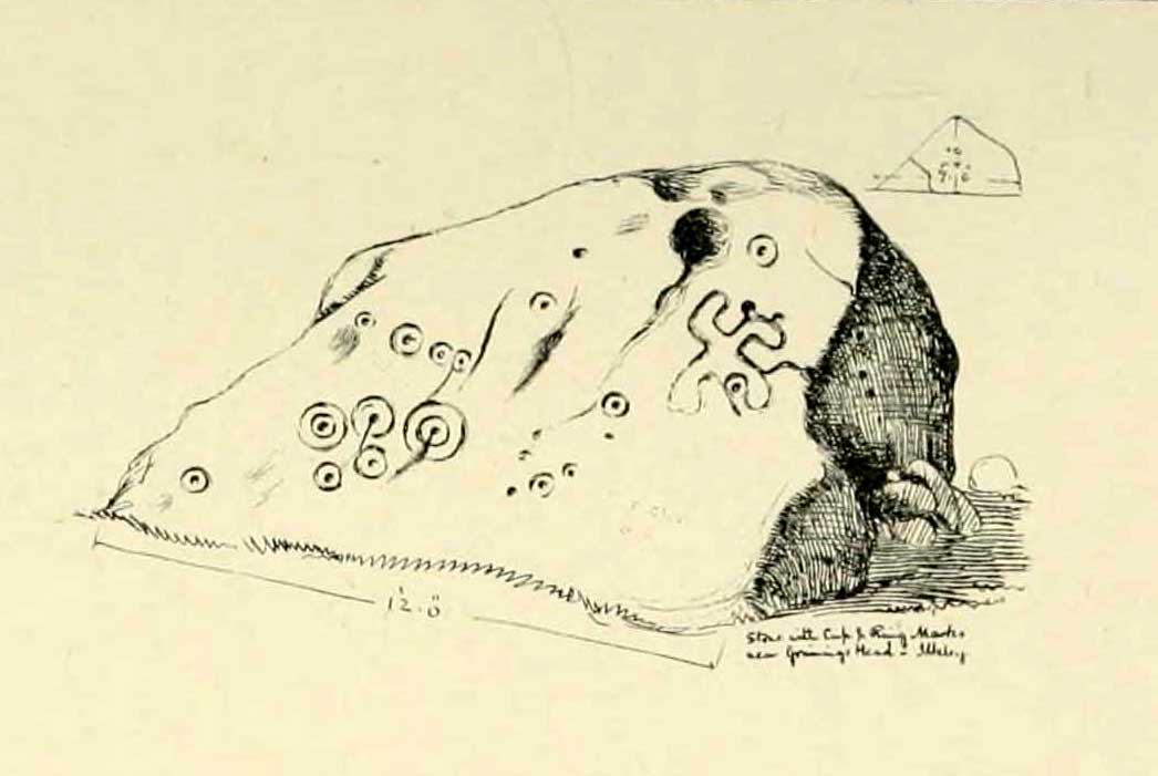
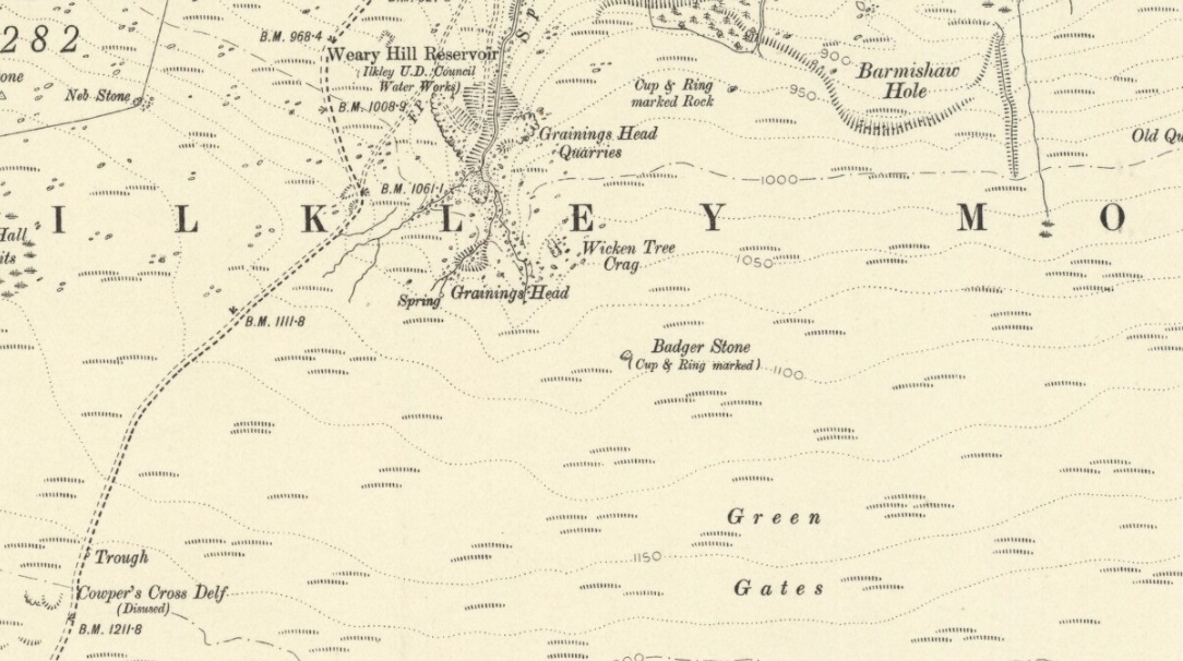
Although there are several routes to this site, for those who are not used to walking or find maps difficult to read [get a life!], it is best approached from the Ilkley side of the moor. Follow the old track that cuts the moor in half past the remains of Graining Head quarry where the moor begins to level out. Once here cut straight east until you find the footpath which, after a while, you will see leads to a wooden seat right in the middle of nowhere. Here is our Badger Stone.
Archaeology & History
An eroded but quite excellent cup-and-ring stone — one of the very best on Ilkley Moor — comprising nearly a hundred cups, ten rings, what seems to be a half-swastika design, plus a variety of other odd motifs. It’s one of the best carvings on the entire moor and has been written about by many folk over the years. First described in an early essay on cup-and-ring stones by J. Romilly Allen (1879) — who must have visited it in poor light, as some elements of the carving weren’t noticed — he described it as a “sculptured stone near Grainings Head”, saying:
“This stone…is a block of gritstone 12ft long by 7ft 6in broad, by 4ft high. The largest face slopes at an angle of about 40° to the horizon, and on it are carved nearly fifty cups, sixteen of which are surrounded with single concentric rings. At the west end of the stone are a group, three cups with double rings and radial grooves. At the other end, near the top, is a curious pattern formed of double grooves, and somewhat resembling the “swastika” emblem… At the highest part of the stone is a rock basin 8in deep and 9in wide. On the vertical end of the stone are five cut cups, three of which have single rings. This is one of the few instances of cup and ring marks occurring on a vertical face of rock.”
Badger Stone on 1910 map
The title “badger” dates back to at least medieval times when, as the Yorkshire historian Arthur Raistrick (1962) explained, the word represented “a corn dealer, corn miller or miller’s man.” It is likely that this traditional title goes much further back, probably into prehistory, as grain was one of the earliest forms of trade. Very close to this sacred old stone are place-names verifying this, like Grainings Head and Green Gates. A little higher upon the moor is the twelfth century Cowper’s Cross (which used to have cup-markings etched upon it) where, tradition tells, a market was held that replaced an older one close by.
The Badger Stone carvingClose-up of cup-and-rings
Our Badger Stone rests beside the prehistoric track which Eric Cowling termed “Rombald’s Way” (after the legendary giant, Rombald, who lived with his old wife upon these hills): an important prehistoric route running across the mid-Pennines. This ancient route runs east-west, traditionally the time of year when agricultural needs are greatest at the equinoxes. This may have been the time when any ancient grain traders met here. (In modern times a number of archaeologists have emphasized such routes as “trade routes”: a notion that derives from the modern religion of Free Market Economics in tandem with the rise of Industrialism and social Darwinism, much more than the actuality of them as simple pathways or means of accessible movement).
There are accounts from other places in Yorkshire about these badger men. We find a number of other “badger” stones, gates, ways, stoops and crosses on our Yorkshire hills. One of them in North Yorkshire, wrote Raistrick (1962), “is an ancient trade way.” In Richmond, North Yorkshire, around the time of the autumn equinox, Badger men from across the Dales followed the old routes over the hills into town, held annual festivities and sold their grain. (see Smith 1989; Speight 1897) It is perhaps possible that our old Badger Stone would have been a site where some form of indigenous British Demeter was revered.
Sketch of Badger Stone carving
Some elements of the Badger Stone carving have what could be deemed as primitive human images (anthropomorphic) mainly on the northwestern side of the rock, emerging from the Earth Herself. And certainly amidst the same portion we have a very distinct ‘solar’ symbol, very much like the ones found at Newgrange and, for that matter, many other parts of the world.
Some New Age folk have given the fertility element to the Badger Stone a deeper status, using imagination as an aid to decode these old carvings. When feminist New-Age writer Monica Sjoo visited Badger Stone she described it as “erotic”, with the carvings giving her a distinct impression of “vulvas” and she also thought orgies of sorts had been enacted here. (Billingsley & Sjoo, 1993) The vulva imagery is a well-known idea to explain cup-and-rings and in some cases this will be valid; but when I passed an illustration of this rock-art to a number of people (all women), there was not a vulva to be mentioned — merely the OM symbol, sperm entering the egg, a snail, a bicycle, a willy, a paw-print, eyes, a face, a tadpole, cartoon breasts, the rear end of a dog, grapes, letters, numbers, ears and a snake! Awesome stuff! Take a look at the design yourself and see what you can see in it. Answers on a postcard please! (The dilemma of making specific interpretations of these carvings is that we tend to approach them with dominant ego perspectives, many of them reflecting little more than our own beliefs or search for identity, imposing unresolved journeys and conflicts on that which we encounter, as with the above case.)
As with prehistoric rock-art in general, they are a number of things: functional, ritual, history, spirit; different at each and every site. As if to exemplify this at Badger Stone, note how the detailed carvings have been executed mainly on the southern face of the stone. The northern face has little if anything to show on it. It would suggest therefore, that this stone had some mythic relationship with events during daylight hours. But we have to be careful here…
At sunrise on a good morning, we note how the eastern edges of this stone show up very clearly indeed. If Nature’s conditions are damp and wet (as they tend to be each morning on the hills), the visible outline of these cup-and-rings show up very clearly indeed. Oddly, as the sun then passes through the daytime sky each and every day on its cyclical movement, the petroglyphic content becomes a little less visible unless the stone is wet. Indeed at sun-high (midday period) the carving doesn’t show up as well as it did in the morning light. And we find the same characteristic as the sun goes to set in the west: where that part of the carved stone shows up very clearly again — much clearer than during full daytime hours. If rain has fallen, the glyphs stand out very clearly indeed.
As all cultures imbued the natural world with animistic, living qualities, it seems probable that these periods of the day (sunrise and sunset) were significant at this particular carving. It may be, very simply, that the Badger Stone “came to life” with the sunrise and its mythic nature was alive during this period; whereas with many other carvings (both on these moors and elsewhere in Britain) their strong mythic associations related to the northern Land of the Dead. But then, I could be talking bullshit!
The Badger Stone is also a strong contender for it being a painted stone. Many petroglyphs like this in other cultures were ceremonially coloured-in using lichens and other plants dyes at certain times of the day or year, relating specifically to important mythic relationships between the people and the spirit of the rock at such places. This probably occurred here.
References:
Allen, J. Romilly, “The Prehistoric Rock Sculptures of Ilkley,” in Journal of the British Archaeological Association, volume 35, 1879.
Bennett, Paul, The Old Stones of Elmet, Capall Bann: Milverton 2001.
Billingsley, John & Sjoo, Monica, “Monica Sjoo in West Yorkshire,” in Northern Earth Mysteries, no.53, 1993.
Boughey, Keith & Vickerman, E.A., Prehistoric Rock Art of the West Riding, WYAS: Leeds 2003.
Hedges, John, The Carved Rocks on Rombald’s Moor, WYMCC: Wakefield 1986.
Cowling, Eric T., Rombald’s Way, William Walker: Otley 1946.
Raistrick, Arthur, Green Tracks on the Pennines, Dalesman: Clapham 1962.
Smith, Julia, Fairs, Feasts and Frolics: Customs and Traditions in Yorkshire, Smith Settle: Otley 1989.
Speight, Harry, Romantic Richmondshire, Elliot Stock: London 1897.
Take the road from Ilkley town centre up towards the White Wells and keep following it along until it curves up and onto the moor itself and becomes a rocky dirt-track. Go up here, past the old quarries (left) until you hit the footpath which runs east (left) onto the flat level of the moorland. Follow this footpath along for literally half-a-mile, where a footpath runs up onto the tops of the moorland. Go up here for 100 yards and you’ll see a small standing stone by the right-hand side of the footpath; on the left, into the moorland about 20 yards away, this carving is to be found!
Archaeology & History
This is an excellent, archetypal cup-and-ring stone carving and is in a very good state of preservation. Found just a few yards away from the aptly-named Pitchfork Stone, the carving here on a large single stone mainly comprises of a double cup-and-ring. A couple of other possible outlying cup-marks can be seen: one just below the double-ring, and the other towards the top-end of the rock. It was first reported by Stuart Feather in the Bradford Archaeology Group’s journal in 1961, then listed in the surveys of Hedges (1986) and his followers.
Carving 257, looking NE
When Michala Potts, Dave Hazell and I we visited this carving the other day, some halfwit had been up here in the not-too-distant past and, as with some of the carvings on the moors north of Ilkley, had daubed some paint or oily resin onto the carvings themselves to specifically highlight aspects of the carved rock (not one part of the uncarved stone had anything on it). We aint quite sure exactly what the substance is that’s been daubed onto the carvings (it aint ordinary paint), but seems like an oil or industrial substance. And, whoever’s done this, obviously seems to have some knowledge of the rock art they’re painting over: they certainly have good grid-references and enjoy walking the hills. This aint just some idiot/s into vandalizing the carvings for the sake of it, nor the whim of some airy-fairy New-Ager. Whoever’s done this (and it’s been done on other cup-and-rings around this locale) have deliberately set out to locate and paint over specific carvings — a number of them off-path — with the intention it would seem to highlight them for photographic enhancement. So — whichever retard has done this, might I suggest that you keep your industrial waste where it belongs: in your own house you fucking moron! If anyone knows who is doing this to the carvings round here, please email me (anonymously if necessary) with all relevant info. Any such communications regarding this matter will be kept strictly confidential.
References:
Boughey, Keith & Vickerman, E.A., Prehistoric Rock Art of the West Riding, WYAS: Leeds 2003.
Hedges, John, The Carved Rocks on Rombald’s Moor, WYMCC: Wakefield 1986.
Walk up from Ilkley to the White Wells and keep following the footpath upwards, up the steps and onto the moor itself. Once you’ve got to the top of the steps above the rocky valley, look straight up the slope in front of you and walk directly up the hill. As you near the top, there’s a large cairn sat on the brow of the hill (known as the Coronation Cairn). This ‘ere carving is just a few yards below it.
Archaeology & History
Very little has been written of this albeit innocuous carving — if indeed it is a carving! Found on the large (though overgrown) flat stone just a few yards below the Victorian cairn, all that we appear to have here is a large cup-marking with a small arc pecked around its southern side and a distinct straight line running outwards from the cup (though the line doesn’t actually touch the cup-mark and does give the distinct impression of being pretty recent). A sort of “cup-and-half-ring” with extended line is perhaps the best description!
Close-up of cup & linesCarved Stone 270
It was first reported by some English Heritage archaeologist — which, as is generally acknowledged, isn’t necessarily a good pointer for authenticity when it comes to identifying prehistoric rock art.* But it’s certainly got a bit more about it than some “carvings” they’ve reported in the past! Boughey & Vickerman (2003) made the following notes of this stone:
“”Low, flat gritstone rock quarried away on E side, fairly smooth but uneven. One large cup and deep groove slightly curving round edge of cup.”
Which is about right. I don’t really think too many of you will be into this unless you’re a real rock-art fanatic!
References:
Boughey, Keith & Vickerman, E.A., Prehistoric Rock Art of the West Riding, WYAS: Leeds 2003.
Hedges, John, The Carved Rocks on Rombald’s Moor, WYMCC: Wakefield 1986.
* A number of cup-marked stones identified by English Heritage archaeologists have transpired to be nothing more than natural erosion.
Just over the county boundary on the north side of the Wharfe’s riverbank, the easiest way to find this is from the village of Burley-in-Wharfedale, walking out as if heading towards Ilkley (west) and, just 100 yards or so before reaching the A65(T) road, walk down the footpath that takes you down to the River Wharfe. Go over the large stepping-stones and, once on the other side, walk down the edge of the riverbank for 10 yards, up the first ridge and there, just below the grass where the edge of the land is coming away, you’ll find this small cup-marking.
Archaeology & History
First discovered t’other day, on Friday, 28 May, 2010, when we were starting on another wander onto the hills. We’d only just crossed the large stepping-stones over the River Wharfe just outside Burley and heading up to Askwith, when Michala Potts stopped, peered and said summat along the lines of, “Errr….look at this!”
Riverbank Cup-MarkingClose-up of cup-mark
My initial thought was it was gonna be some naturally eroded water-worn stone — but it didn’t seem that way. Peering out from the edge of the ground n the company of many other small stones and gravel, which was slowly coming away just yards above the edge of the river, a rounded cup-marked stone with just a single cup-mark stood out like a sore thumb! It was covered in dusty earth and looked a quite decent example; but once we’d cleared the dried earth away and wet the stone, the cup-marking was truly enhanced. To those of you who have a thing about cup-markings and associations with rivers and streams, this one can be added to your statistics! (20 yards away the Askwith East Beck meets with the river)
Obviously added as part of the river embankment, the stone would obviously have been taken from a nearby source, but we’re unlikely to ever find out where. It looks typical of cup-marked stones that were added to cairns, but no such site (that we know of) occurred close by. We were gonna peel some of the embankment back and see if there was anything else here, but time and another ancient site that we’d arranged to see was calling us away, so we just got a few pictures and kept on our way…
Start at the Askwith Moor parking spot on Askwith Moor Road, then walk down the road (south) 300 yards till you reach the gate and track on the other side of the road, heading southeast. Following the track onto the moor and take the footpath on your right after 75 yards. Follow this along until you hit the gate & fence. Climb over this, then follow the same fence along (left) and down, and keep following the fence and walling all the way on until you reach the very bottom southwestern edge of Askwith Moor itself. Now, walk up the slope to your right and, near the top of this rise 200 yards or so away are 2 or 3 rocks close to each other. You’re here!
Archaeology & History
On the small, unnamed hill at the very far southwestern edge of Askwith Moor, within the unrecorded Lower Lanshaw enclosure is this previously unrecorded cup-marked stone that has been found thanks to further heather burning operations hereby. But it’s nowt much to shout about if you’re after big colourful designs. This is merely one of the many single cup-marked rocks scattering the Yorkshire uplands. The large pecked cup, nearly 2 inches in diameter, is found on the lower eastern end of a long, sloping stone. Along the same ridge are also faint remains of ancient walling.
A very faint cup-and-ring stone can be found just over the brow of the hill from here, about 30 yards northeast (at SE 16059 50875) in the northeastern edge of the Bronze Age enclosure walling.
From the Askwith Moor Road parking spot and walk up the road for about 500 yards an head to your right (east) onto he moor, above the rocky ridge known as Snowden Crags. After 100 yards or so of walking through the heather, the entire cairnfield is under your very feet! If the heather’s grown, you probably won’t see a thing.
Archaeology & History
First described in Eric Cowling Rombald’s Way (1946), where he mentions around 30 cairns on the moorland plain immediately west of the Snowden Moor settlement. These were plainly visible when Richard Stroud and I visited here in 2005, thanks mainly to the fact that the heather had been burnt away. Once it’s grown back, virtually all of these tombs will be hard to find. I first had fortune to see some of these tombs on a visit here with Graeme Chappell about 15 years ago, but only a little of the cemetery was then visible. Following another visit to the site this week, a great deal more has become visible, thanks again to heather-burning on the moors.
One of around 30 cairns on the ridge…and another one!
Curiously omitted from the Nidderdale Archaeological survey report of sites in this region (anyone know why?), the cemetery itself stretches from the western edge of the Snowden Moor settlement, several hundred yards west along the flat moorland plain towards the moorland road, stopping a short distance before the line of old grouse butts. It is highly likely that some of the stones in the grouse-butts originated in some of the prehistoric cairns along the ridge. And if summat aint done about it, there’s a likelihood this could easily happen again in the near future.
…and another!
The easternmost cairn touches the very edge of the D-shaped settlement; and another of them is right next to a cup-marked stone. Whilst a number of the cairns along this ridge are much like those found on the moors above Ilkley, Bingley, Middleton, Askwith Moor, Earby, etc — averaging 2-3 yards in diameter and less than 2 feet high amidst the peat and decaying herbage — one notable feature to many of these tombs is the inclusion of a rather large, singular boulder, against which or around are propped the smaller stones, typical of cairns found elsewhere in the region. This ‘large boulder’ characteristic is not common at other tombs in the mid-Pennines, but seems specific to this graveyard. Neither do the large boulders seem set in any particularly consistent fashion. There is the possibility that they were originally above the smaller cairn of stones, but this is purely hypothetical and non-verifiable without excavations.
The important Snowden Crags cairn circle, discovered by the hardworking Keighley volunteer Michala Potts on Thursday, 20 May, 2010, can be found on the northern part of this cairnfield.
References:
Cowling, Eric T., Rombald’s Way: A Prehistory of Mid-Wharfedale, William Walker: Otley 1946.
Get here before the heather grows back! From the Askwith Moor parking spot, walk up the road (north) and turn left on the moorland track, past the triangulation pillar, then the ranger’s hut on the edge of the hill, and head WNW along and down the gradual slope. You’ll get to a row of grouse butts after a few hundred yards and, if you’re lucky to find it, an old OS trig-marked arrow carved on one of the low-lying stones. This stone is about 10 yards away from the cairn!
Archaeology & History
There are no previous references to this site. It was discovered by the hardworking Keighley volunteer, Michala Potts of Bracken Bank, on May 20, 2010, and was the most visible of at least three prehistoric cairns on the sloping edge of this hill. The main one illustrated here is about 3 yards in diameter and only a foot or two high. Typical of the many Bronze Age cairns scattering the moors north and south of here, several others are in close attendance. It seems as if some of the stone from this cairn has been robbed to build some of the grouse-butts that stretch across the moors hereby.
Single cairn on Askwith MoorSame cairn, looking uphill
About 50 yards away from the main cairn shown in the photos are a couple of others of the same size and nature. And if we walk over the other side of the nearby rounded hill immediately south, a couple of other cairns are in evidence. However, we didn’t spend too much time here getting any images, as other sites on the moor were beckoning and we were running out of good daylight!
The name of this area seems a little odd: “High Low” — and our old place-name masters say little about it in the Yorkshire directories. The name is shown in the earliest large-scale OS-maps, but the contradiction of a high low ridge probably derives from the word originally being lowe, or “hlaw”: which as A.H. Smith (1956) said,
“In (old english) the common meaning in literary contexts is ‘an artificial mound, a burial mound,'”
Cairn to centre, with 1 more on near horizon
which is exactly what we have found here — or several of them scattered about. This tumulus derivation is echoed by modern place-name authorities like Margaret Gelling (1988), etc. Gelling told how the word hlaw, or low, and its variants, “was used of burial mounds over a wide area, from the south coast to the West Riding.” Much as we’ve found on this hill at Askwith Moor! We’ve yet more exploring to do in and around this area in the coming weeks. God knows what else we’ll find!
References:
Cowling, Eric T., Rombald’s Way: A Prehistory of Mid-Wharfedale, William Walker: Otley 1946.
Gelling, Margaret, Signposts to the Past, Phillimore: Chichester 1988.
Smith, A.H., English Place-Name Elements – volume 1, Cambridge University Press 1956.
Walk about a mile along West Lane from Askwith village, towards Ilkley, until you reach a notable rounded bend in the road where, in the field immediately above you (behind the thorns) on your left, is a small scatter of large rocks at the edge of the field. One of these is what you’re after! (although this stone is just a couple of yards from the roadside, you can’t just pull up here and have a look — unless you’re an idiot! — without causing one hellova bad accident. So don’t do it!)
Archaeology & History
Carving no.509, Askwith
First described in Boughey & Vickerman’s (2003) survey, this is a curious “design” — if indeed that’s the right word! On the upper surface we can see, very clearly, one large cup and two deep curved lines set away from the cup-marking. One of these lines appears to curve along and down the edge of the rock and, on the shaded side below (somewhat overgrown with nettles when we were looking at it), what may be another large cup-mark and a continuation of the same “carved” line, roughly as drawn in the 2003 survey. It looks pretty good (if you’re a sad rock-art freak like me), but there could be another reason for the markings…
A mile upstream on the eastern edges of the wooded Scales Gill valley (known in previous centuries as both St. Helen’s Ghyll and the Fairy Dell), recent forestry and industrial work has scarred a number of rocks with engraved lines upon more faded cups or gunshot marks. When we wandered up here a few days ago and found a couple of these recently scarred stones, I remarked on how, in years to come, unless we made note of these very modern curves and grooves on the rocks, that future archaeologists will be cataloguing them as cup-and-ring stones. Several hours later on the way back home from our moorland wanderings, we ventured upon this, stone no.509.
I mention this for good reason: as a century back, only 100 yards away, are the remains of what was an old quarry that used industrial machinery similar to the ones that have made the recent curved markings on the stones a mile up the valley. And as we can see quite clearly with this stone and its companions, they’ve been moved and dumped into their present position at the field-side. We should keep this ingredient in mind when looking at this stone, just in case the archaeologists who’ve logged this as prehistoric have got their dates out by a few thousand years. With any luck however, I’ve got it all wrong…
References:
Boughey, Keith & Vickerman, E.A., Prehistoric Rock Art of the West Riding, WYAS 2003.