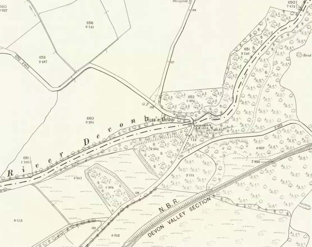
Somewhere hiding away above the north-side of the River Devon, just above the Vicar’s Bridge, a little-known healing well came into being following industrial workings in the glen in 1831 by a local iron-working company. The waters were strongly chalybeate, or iron-bearing—and as the fad amongst the wealthy was, at the time, a love of Spa Wells, this mineral spring was broadcast as a competitor of the Harrogate and Bath Spas. But it failed pretty fast, sadly.
Bottles of the water were marketed and sold as ‘Dollar Mineral Water’ in many of the large cities, but sales weren’t too good. Johnston & Tullis (2003) pointed out how the waters would have been coloured like brandy; and despite it being good for anaemia, a good tonic, and favourable in treating cuts and bruises, the mineral spring was no longer of any value as a business, dying a quick death. Local people still kept using the waters, but in recent years the spring appears to have died too.
References:
Johnston, Tom & Tullis, Ramsay (eds.), Muckhart, Clackmannanshire: An Illustrated History of the Parish, MGAS 2003.
Healing Well (destroyed): OS Grid Reference – SE 1174 3443
Archaeology & History
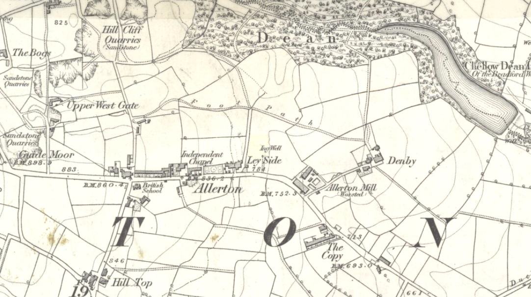
Ing Well on 1852 map
This ‘Well of the Meadow”, or Ing Well, is one of countless springs in and around the Bradford metropolis that have been destroyed by that thing they call ‘development’. It was one of the main water sources for the villagers of Allerton village in the 19th century and earlier. Highlighted on the 1852 OS-map of the region, a singular footpath once led to the waters and no further. There appear to be no antiquarian or historical references detailing its traditions or medicinal qualities—unless of course, you know different.
The name Ing Wells is one of the most common of all titles given to water supplies in England, meaning having the same meaning and general history just about everywhere it occurs. The place-name itself was given extensive attention in two separate studies by Eilert Ekwall (1962) and Sigurd Karlstrom (1927).
References:
Ekwall, Eilert, English Place-Names in -Ing, Lund: Uppsala 1962.
Karlstrom, Sigurd, Old English Compound Place-Names in -Ing, Lund: Uppsala 1927.
Musselburgh has had an ancient fair—held upon St. James’ Day (July 25)—for many centuries. It was held along the old High Street by a more ancient Market Cross than the one seen there today. R.M. Stirling (1894) told us that, “The cross is erected over a draw-well, and in local parlance is known as the Cross Well.”
On the 1853 township map, a water ‘pump’ is shown at the very spot, with the ‘cross’ and water trough shown on subsequent maps. The Well isn’t mentioned in John Small’s (1900) description of the cross and its authenticity as a ‘holy’ well is questionable.
Holy Well (destroyed): OS Grid-Reference – NT 3452 7264
Archaeology & History
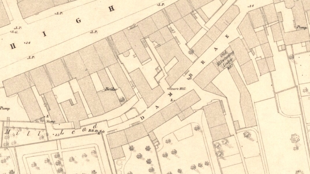
Vicars Well on 1853 map
First mentioned in the Scottish Statistical Account of 1845, its name originates from being attached to the vicarage of nearby St. Michael’s church. Highlighted on the 1853 township map of Musselburgh, this forgotten holy well was described in the middle of the 19th century by local historian James Paterson (1857). It was located near the middle of town, along a back-street south of the High Street. Mr Paterson told us that:
“At the Dam Brae there is still a well, celebrated for the excellence of its water, called ‘the vicar’s well’, from which it is believed the present manse occupies the site of the ancient vicarage. It lies to the southeast of the Brae, and the wall of the ground approaches pretty close to the mill lead, or damn, as it is called. It is well surrounded with old trees.”
When it was described by Mr Beveridge in the 1845 Statistical Account, the spring had been covered by a pump. Local lore told how the waters of this ancient Well was said by housewives to be excellent in the infusion of tea; and although its name was spoke in local dialect as the ‘Bickers Well’, Beveridge told it to mean the “Vicars Well.” There is the obvious possibility that the ‘bickers’—as in chit-chat and gossip—related to it being where local folk simply met and chatted.
When Mr Stirling (1894) wrote his account of the adjacent Inveresk parish, he told how water from the Vicar’s Well,
“was in much request till a few years ago, when its use was forbidden and its site enclosed (for) sanitary considerations.”
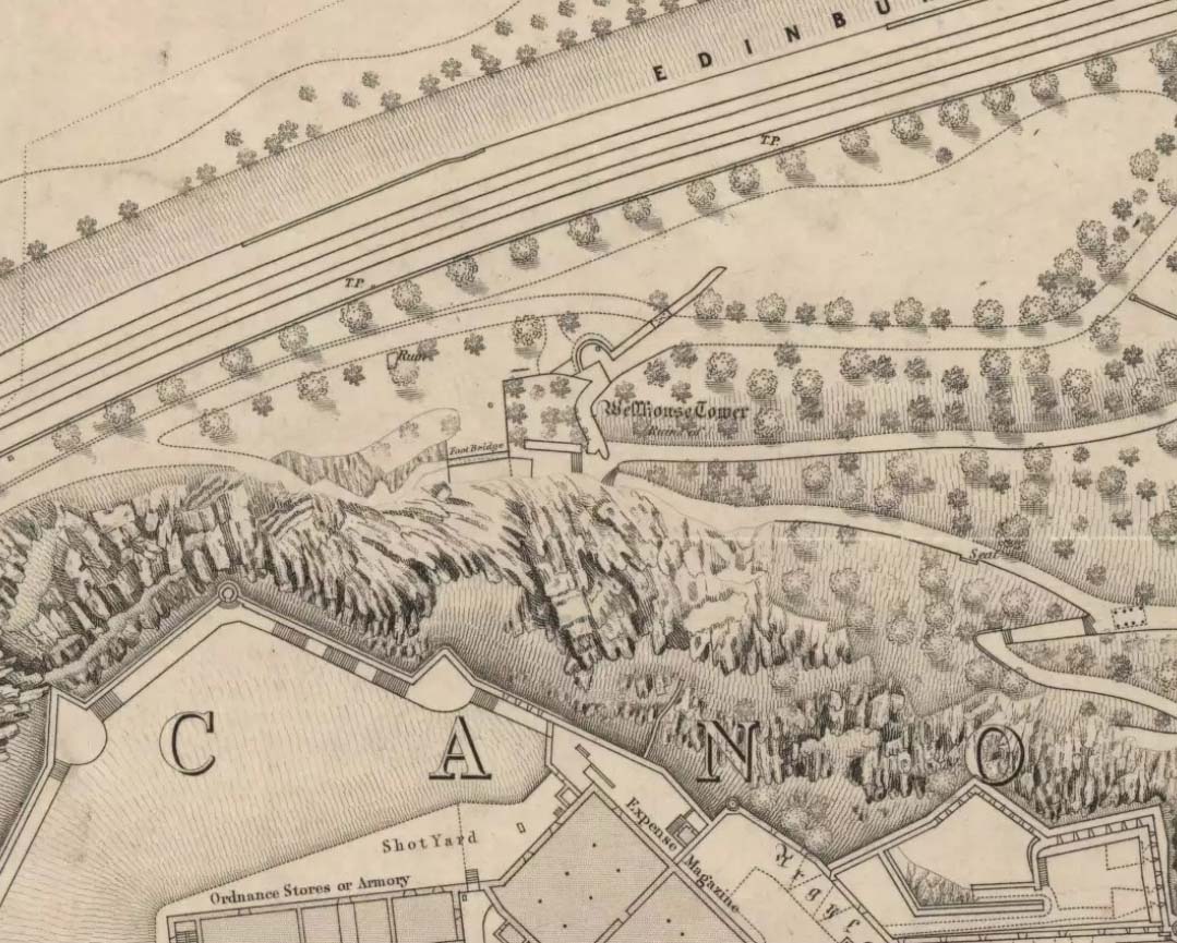
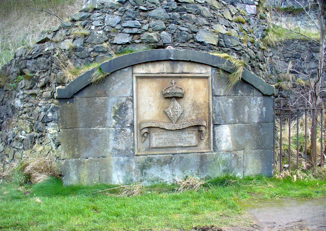
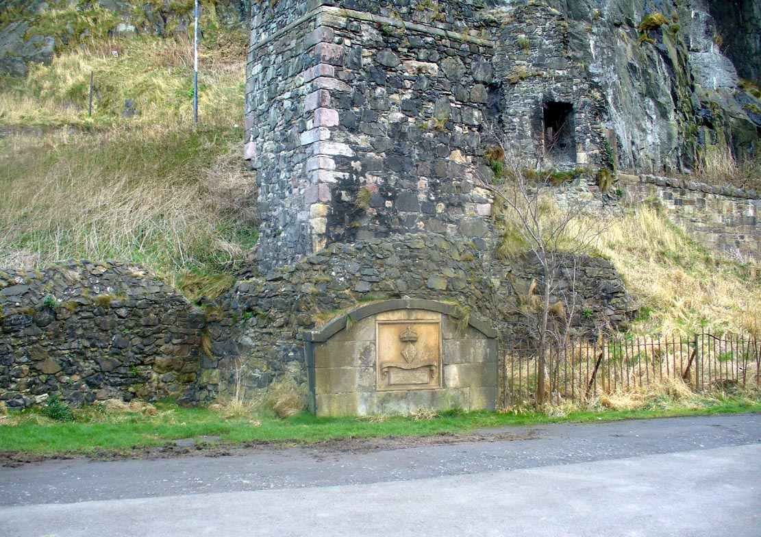
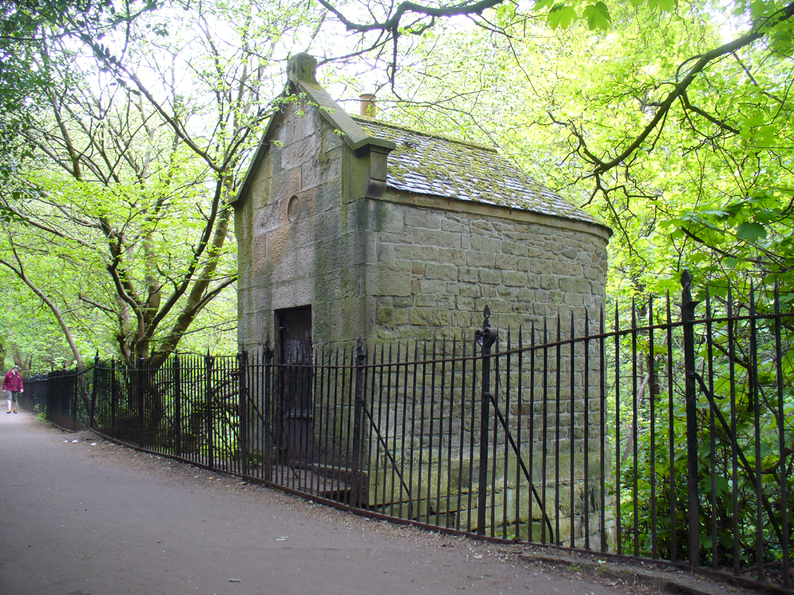
Along the more western end of Princes Street, looking up at the castle, wander into the park below and walk towards the railway line. There’s a foot-bridge over it. Once on the other side, turn right and walk along the path for just over 100 yards until you’re just about beneath the cliffs. There, in front of you, a ruinous stone building and carved faded plaque reads “St Margaret’s Well.”
Archaeology & History
The bedraggled architectural remnants we see of St. Margaret’s Well today, is not where the waters originally emerged. We must travel 2-300 hundred yards west of the present edifice, along old Kings Stables Road near St Cuthbert’s Church, for its original position. Long since gone of course…
Close-up of plaqueSt Margarets, by the old ruins
The history of this holy well tends to be found scattered in a number of sources—but none give us a decent narrative of its medicinal or traditional lore. Perhaps the best was conferred in W.M. Bryce’s (1912) lengthy essay on St. Margaret’s chapel where he told:
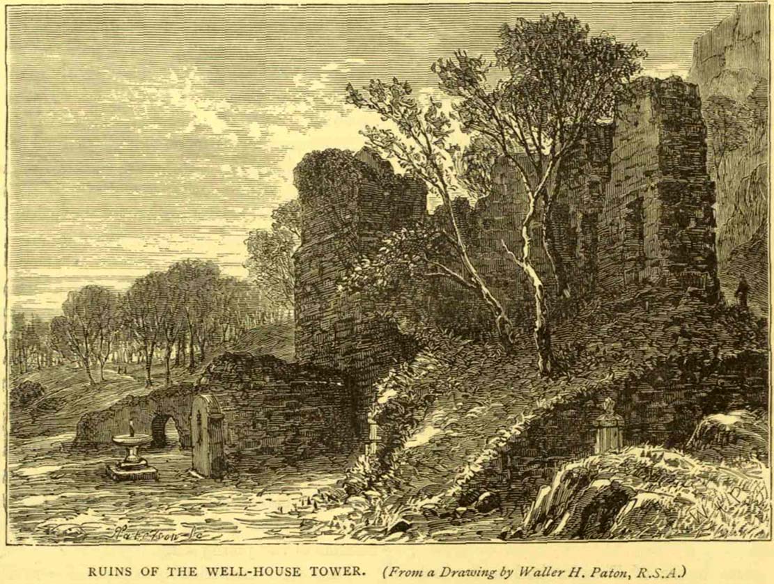
“Of the fountain in West Princes Street Gardens, also known as St. Margaret’s, and for the protection of which the Well-house Tower was erected in 1362, no legend of a similar nature seems to have survived. It was a little flowing stream of pure water, and down to the year 1821 was utilised for drinking purposes for the supply of the garrison, in supplement of the ancient draw-well of the Castle. The earliest notice of this fountain appears in a charter by David I in favour of the Church of St. Cuthbert, dated circa 1127, in which he conveys the land under the Castle from the fountain which rises close to the corner of the King’s Garden, and along the road leading to the church. It was here, in this royal garden, beside the pellucid waters of the well which was afterwards to bear her name, that Queen Margaret, in the company of her husband and children, spent many a sunny afternoon under the shade of the rugged old Castle rock.”
St Margarets Well in 1870s
The carved plaque in front of the old tumbled-down well-house sadly hides no water anymore; merely some trash and heroin-addicts needles at the back. Best avoided.
Folklore
This Scottish Queen and consort of King Malcolm Canmore, ‘St Margaret’, had several days in the calendar on which she was commemorated. Mrs Banks (1941) told how, traditionally, her day is June 10:
“This day was appointed for her festival by papal decree, but in Scotland her day is that of her death, November 16. The festival of her translation was commemorated on June 19th.”
W.M. Bryce (1912) cited St Margaret’s Day to be generally accepted as June 19, which is closer to Midsummer and could easily be accommodated into local heathen traditions.
References:
Banks, M. MacLeod, British Calendar Customs: Scotland – volume 3, Folk-lore Society: London 1941.
Royal Commission on the Ancient & Historical Monuments, Scotland, Inventory of the Ancient & Historical Monuments of the City of Edinburgh, HMSO: Edinburgh 1951.
Healing Well (destroyed): OS Grid Reference – NT 314 735
Archaeology & History
This was one of two medicinal springs that could once be found in old Portobello village. Like its companion Chalybeate Well nearly a mile northwest, in the early 19th century those entrepreneurial types tried fashioning these waters into being a Spa Well. It didn’t really work and the fad passed after just a couple of decades—and soon after the local people had completely lost their water supply here. The best historical account of it is in William Baird’s (1898) magnum opus on Portobello. He told how the well,
“was, at the beginning of the century, situated in a garden near to the main road, where there was a well with drinking cups for the accommodation of visitors, a small sum being charged from those using it. The supply here having in some way become interrupted the spring was neglected for a time. It found vent, however, lower down and nearer to the Promenade at the foot of Joppa Lane. About fifty years ago there was a pretty large open basin, in the centre of which the water bubbled up about half a foot. It was of a red brick colour. Unfortunately on the starting of a pump on the Niddrie Bum to drain the water from the Niddrie coal pits, the supply of water was again interrupted, and this excellent mineral spring, which was strongly impregnated with oxide of iron and sulphate of lime and magnesia, ceased to flow with its former fulness.”
In 1869, the Industrialists dug into the Earth to construct their promenade and, after countless centuries, the waters of this old medicinal well finally died and fell back into the deep Earth…
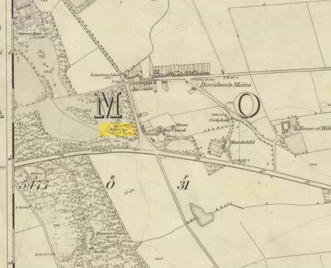
From the west end of Prince Street in Edinburgh central, take the (A90) Queensferry Road. Go along here for 2.2 miles (3.5km) where the A90 meets the A902. Keep going west along Hillhouse Road for literally 1km (0.62 miles) where you reach a crossroads with the B9085 and there are trees on the right (north) side of the road. Go into these trees and, before you come out into the fields on the other side, about 150 yards in, walk to your right and zigzag about in the undergrowth. A small muddy pond is what you’re looking for!
Archaeology & History
Out towards old Lauriston Castle on the northwestern outskirts of the city, these all-but forgotten healing waters became renowned for a short period of time in the latter-half of the 18th century. They were described in John Law’s Parish of Cramond (1794) where, with some brevity, he told that,
“On the lands of Marchfield is a spring of mineral water called the well of Spaw, reckoned beneficial in scorbutic cases, and highly purgative if drunk copiously.”
It was highlighted in the trees on the earliest OS-map (above) and its ruined remains can still be found. Stone-lined, the watery remains of this old healing well (undoubtedly a place used by local people before the toffs named it as a ‘spa’) are thankfully still running. Two other spa wells could be found not far away: one at Lauriston castle, and the other at Barnton.
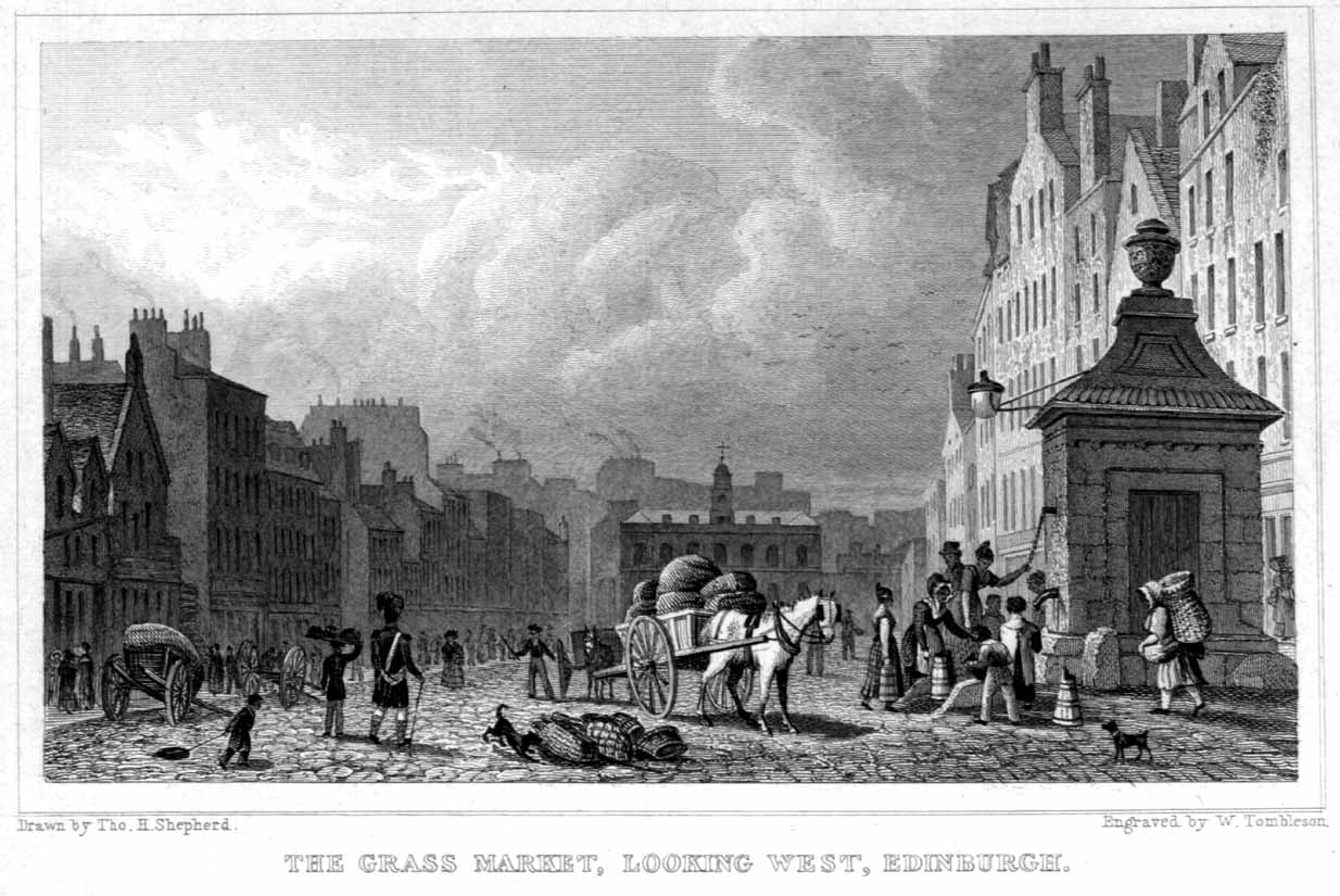
Once you’re in Edinburgh, there are so many ways to get here (and it’s easy to get lost with city directions, depending on where you’re starting out from), so just get to the south-side of Edinburgh Castle and find the long cobbled-road of the Grassmarket. Ask people if you can’t find it, they’re very helpful in Edinburgh (totally different from London!). It’s the large carved square stone-feature near the bottom of the road.
Archaeology & History
Very much the product of the Industrial Age, this large ornate architectural feature at the cobbled junction of Grassmarket, Cowgatehead and West Bow, was built by Robert Mylne in 1681. The well gave the people of the city a water supply after redirecting waters from the Comiston Springs, 3 miles away, into Edinburgh. It was one of a number of public wells constructed in the city specifically for use by the general populace “when a dry season occurred,” reported Mr Colston (1890). A dry season?! – in Scotland?! In the 19th century it became unreliable as a source of good drinking water. It has no archaic animistic veracity.
Along the B925 road between Dunfermline and Kirkcadly, ⅔ of a mile (1.07km) west of Auchtertool village, go down the small track leading down to the isolated church on the rise in some trees. Walk through the churchyard and out the other side where a small footpath runs downhill. 50-60 yards along, by the walling, this holy well is/was said to be.
Archaeology & History
Both history and tradition are pretty shallow on this all-but-forgotten site, which Penny Sinclair guided us to see in the summer of 2016. Sadly the entire area where the waters are reported to emerge were completely overgrown in nettles when we visited and, despite us trampling the Urtica down, we could find no remains of the spring. (the Church and its followers here should ensure that the well is properly maintained)
The greatest description of the site seems to be that given by William Stevenson (1908) in his rare work on the parish of Auchtertool. He wrote:
“As you approach the Kirk of Auchtertool by the old road…you come upon a well by the wayside. For many years it was the well that supplied the Manse with water, but it is now seldom used, even by the passing traveller. There is a belief that at one time this well was what is known as a holy well. Be that as it may, a friend of the late Rev. Walter Welsh, the late Dr Robert Wilson, caused a stone over the well to be inscribed with the following lines:
“Ye who the gently-winding path have trod,
To this fresh fount beside the house of God,
Taste the clear spring; and may each pilgrim know
The purer stream where living waters flow.””
The well was included in Ruth & Frank Morris’ (1982) survey, where they added that the waters from the well were “used in celebration of the mass.”
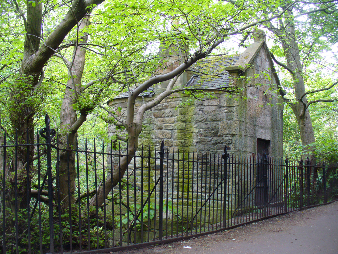
In Edinburgh, get to the west-end of Princes Street (nearest the castle), and where there’s the curious mess of 6 roads nearly skewing into each other, head down Queensferry Street for 450 yards until, just before you go over the bridge, walk down Bells Brae on your left, then turn right down Miller Row where you’ll see the sign to St. Bernard’s Well. St. George’s Well is the small, dilapidated spray-painted building right at the water’s edge 200 yards before St. Bernard’s site.
Archaeology & History
Compared to its companion holy well 200 yards downstream, poor old St. George’s Well is a paltry by comparison, in both historical and literary senses. The site was said to have been “set up in competition with St Bernard’s Well but never achieving its purpose”, wrote Ruth & Frank Morris (1982)—which is more than a little sad. Not on the fact that it failed, but on the fact that some halfwits were using local people’s water supply to make money out of and, when failing, locked up the medicinal spring and deny access to people to this day!
In Mr Grant’s Old & New Edinburgh (1882), the following short narrative was given of the site:
“A plain little circular building was erected in 1810 over (this) spring that existed a little to the westwards of St. Bernard’s, by Mr MacDonald of Stockbridge, who named it St. George Well. The water is said to be the same as the former, but if so, no use has been made of it for many years…”
St George’s Well, looking NSt George’s Well, looking SW
The association to St. George was in fact to commemorate the jubilee of King George III that year. If you visit the place, the run-down little building with its grafitti-door has a small stone engraving etched above it with the date ‘1810’ carved.
As the waters here were found to possess mainly iron, then smaller quantities of sulphur, magnesia and salts, it was designated as a chalybeate well. Its curative properties would be very similar to that of St. Bernard’s Well, which were very good at,
“assisting digestion in the stomach and first passages … cleansing the glandular system, and carrying their noxious contents by their respective emunctories out of the habit, without pain or fatigue; on the contrary, the patient feels himself lightsome and cheerful, and by degrees an increase to his general health, strength and spirits. The waters of St. Bernard’s Well operates for the most part as a strong diuretic. If drunk in a large quantity it becomes gently laxative, and powerfully promotes insensible perspiration. It likewise has a wonderfully exhilarating influence on the faculties of the mind.”
Royal Commission on the Ancient & Historical Monuments, Scotland, Inventory of the Ancient & Historical Monuments of the City of Edinburgh, HMSO: Edinburgh 1951.