Addlebrough (1), Thornton Rust Moor, North Yorkshire

Cup-Marked Stone:  OS Grid Reference – SD 948 879

Getting Here

This takes a bitta getting to and won’t really be worthwhile unless you’re a rock-art nut!  I s’ppose if you’re looking at the other decent cup-and-ring stones on the summit of Addlebrough, it might be worth looking at.  In which case, walk a coupla hundred yards southeast towards where the walling meets and climb over.  The walk a little further in the same direction and once you’ve gone less than 100 yards, look around.  You can’t really miss it if you potter about.

Archaeology & History

Single cup-marked stone (photo by Richard Stroud)

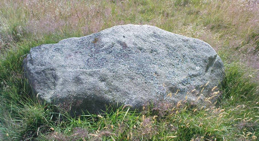
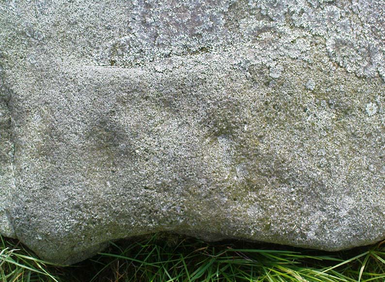
This possible single cup-marked stone appears to have been discovered before me ‘n Richard Stroud got to the spot, by none other than Stan Beckensall himself — or at least it’s in Stan’s Prehistoric Rock Art of County Durham, Swaledale and Wensleydale book, where he describes it as it only can be done: “a single possible cup-marked stone…SSE of the summit cairn”, which is where you find this. (Another single cup-marked stone found nearby by Barbara Brown aint the same one as this.)

References:

  1. Beckensall, S. & Laurie, T., Prehistoric Rock Art of County Durham, Swaledale and Wensleydale, County Durham Books 1998.

© Paul Bennett, The Northern Antiquarian


Pathway Stone, Holden, Silsden, West Yorkshire

Cup-Marked Stone:  OS Grid Reference – SE 07021 44884

Also Known as:

  1. Rough Holden CR-9

Getting Here

Pathway Stone, Holden, Rivock

Follow the footpath running from the Rivock TV mast northwest, where it cuts diagonally across the field, heading towards the drystone wall.  About 200 yards before the walling – stop! It’s just to your right-hand side, very close by!

Archaeology & History

First discovered in July 2009 when Keighley volunteer, Michala Potts of Bracken Bank, did further ramblings amidst the long grasses hereabouts.  Its name comes from the fact that it’s found just next to the footpath that cuts across Rough Holden from the TV mast beneath Rivock.  The carving’s a very simple plain design, as the photos show, with just three faded cup-markings etched onto the stones northeast face.

Close-up of cup-markings

This stone aint too far from the cup-marked Dump Stone and the nearby Rough Holden design, but all across the Holden Rough grasslands are the faded remains of old pit-workings.  It makes you wonder just how many other carvings once existed across this flatland.  The fact that this and the other ones nearby still remain is damn fortunate!

© Paul Bennett, The Northern Antiquarian


Netherurd Mains, Kirkurd, Peeblesshire

Cross:  OS Grid References – NT 1041 4403

Also Known as:

  1. Canmore ID 50098
  2. Swastika Stone

Archaeology & History

Swastika X, Netherurd
Netherurd’s Swastika Cross Stone

This supposedly 10-12th century carving — found in the early 1940s and handed to the Scottish National Museum in Edinburgh by Mr A. Sanderson — took my interest by virtue of the distinct swastika design carved on the face of the stone.*  The fact that it’s etched onto what’s thought to be the remains of an old christian cross shouldn’t be too surprising: we find it on numerous other old stone crosses, church bells and other religious remains.

This example was only carved on one side of the stone, which measures some 18-inches high and just 9 inches across.  The top of the stone has a design typical of many early crosses from between the 9th to 14th century; whilst the curvaceous line on the lower-right also typifies imagery found on many crosses from this period — some of which appear to be based on cup-and-ring imagery.  However, no such cup-and-rings seem to have been in evidence where this cross-remain was found.  Very little else is known about its history.

Although it aint quite as old as Ilkley’s Swastika Stone, this is still a fascinating carved stone indeed!

References:

  1. Royal Commission on the Ancient & Historical Monuments of Scotland, Peeblesshire – volume 1, HMSO: Edinburgh 1967.
  2. Stevenson, Robert B.K., ‘The Inchyra Stone and some other Unpublished Early Christian Monuments’, in PSAS 92, 1961.

* To those who don’t know, the swastika symbol has been used by people from around 20,000 BC onwards and has only very recently gained a bad press.  It’s a symbol that needs to be reclaimed, through education, and put back into its proper mythic place where it belongs – away from any Nazi dip-shits, whose retarded actions pale into insignificance when it comes to the primal archaic nature of this old form.

© Paul BennettThe Northern Antiquarian


Dump Stone, Holden, Silsden, West Yorkshire

Cup-Marked Stone:  OS Grid Reference – SE 0705 4490

Getting Here

Top view of cup-marks

Follow the same directions as to reach Holden’s Buttock Stone, then north over the field and through the gate towards the Rough Holden Carving.  As you approach here, keep your eyes peeled for a clump of boulders a little further down the field which stand out.  That’s where you wanna be!

Archaeology & History

Found by the old Keighley volunteer, Michala Potts of Bracken Bank, a few weeks back (Friday, June 12, 2009), this previously undiscovered cup-marked boulder is amidst a scatter of boulders piled-up with each other following a field-clearance in recent years.  It doesn’t seem to be in its original position, but obviously came from the fields hereby.

Cup-Marks on vertical face
Side view of cup-marks

The first view we got indicated 2 or 3 cup-markings on its upper surface; but then as we wandered round it and the adjacent rocks, it seemed that several others appear to have been etched on the vertical face, as shown in one of the photos.  The light wasn’t too good by the time we found this (it was one of those days where cloud and sun kept the cup-marks hidden at times!) and then a drizzle came along and stopped a sketch of the stone.  But it’s obvious there are 3-4 cup-markings on the upper surface and at least 3 carved on its side.  Next time up there we’ll hopefully get better light!

One of the land-owners or tenant farmers hereby has little respect for the prehistoric remains in this area and, in all honesty, I’d expect a number of the petroglyphs to be destroyed in the coming years.

© Paul Bennett, The Northern Antiquarian


Cunninghar, Tillicoultry, Clackmannanshire

Stone Circle (destroyed):  OS Grid Reference – NS 9256 9709

Also Known as:

  1. Druidical Temple

Archaeology & History

A stone circle was once to be found on the elevated piece of ground above the north-side of the main road between Tillicoultry and Dollar, but it was sadly destroyed sometime in the 19th century.  Listed in Aubrey Burl’s (2000) magnum opus, we have very little information about the place; though an account of the site was described in the Scottish Royal Commission report (1933) which told us that a —

“Stone circle, measuring about 60 feet in diameter, once stood here but was completely removed many years ago, when the stones, which are said to have been 5½ feet in average height, were taken to cover a built drain at Tillicoultry House”!

Site shown on 1866 OS-map
Stone at the destroyed site

Unbelievable!  Any decent local folk nearby wanna find out where this drain is, see if the stones are visible (though I doubt they are), so we can plan to uproot it and move the stones back somewhere nearby. There are a few decent spots on the slopes above where it would look good!

When visited by researchers in the 1890s, parts of an embankment which surrounded the destroyed circle were still visible.  Also, indicating there was some ritual funerary nature to the site, a local teacher called Mr Christie found the remains of an ornamented urn protruding through the ground next to where one of the monoliths had stood.  Unfortunately in his attempts to remove the urn, much of it crumbled away.

Further examinations thereafter found that a burial was (seemingly) beneath the centre of the circle; and excavations here found that a covering stone of the tomb was covered in intricate cup-and-ring designs (see the Tillicoultry House Carving for further details).  Other prehistoric remains were found a little further up the hill from here.

References:

  1. Burl, Aubrey, The Stone Circles of Britain, Ireland and Brittany, Yale University Press 2000.
  2. Morris, Ronald W.B., The Prehistoric Rock Art of Southern Scotland, BAR 86: Oxford 1981.
  3. Robertson, R., ‘Notice of the Discovery of a Stone Cist and Urns at the Cuninghar, Tillicoultry…’, in PSAS 29, 1895.
  4. Royal Commission on the Ancient & Historical Monuments of Scotland, Fife, Kinross and Clackmannan, HMSO: Edinburgh 1933.

© Paul BennettThe Northern Antiquarian


Robin Hood’s Wood (3), Silsden, West Yorkshire

Cup-Marked Stone:  OS Grid Reference – SE 06530 44898

Also Known as:

  1. Holden CR1

Getting Here

Follow the same directions to reach the Robin Hood’s Wood Stone, but head from there to the dirt-track about 30 yards away.  This stone is just 10-15 yards on the south-side near the bend in the track.  Look around!

Archaeology & History

Holden Cup-Marked Rock

If you can find this stone, the 2-cupped Robin Hood’s Wood Stone carving is only about 15 yards SW.  But this poor example is a mere single cup-mark sitting near the centre of a large flat rock, half-covered in vegetation like its nearby compatriot.  There’s a faint possibility of a second cup-mark on the rock, but it’s pushing it a bit!  Thanks to the vegetation cover on the majority of the rock, the cup’s in a good state of preservation.  Nowt much to shout about unless you’re a real cup-and-ring nut!

© Paul Bennett, The Northern Antiquarian


Robin Hood’s Wood CR-2, Silsden, West Yorkshire

Cup-Marked Stone:  OS Grid Reference – SE 06521 44887

Getting Here

Follow the same directions for reaching the Baldwin Stone.  From here, with your back to the wall, face the small remnants of Robin Hood’s Wood and walk straight to where the game-keeper’s stuff is in the trees 150 yards straight in front.  Go through the small copse and out the other side, in a straight line for another 70 yards.  This stone’s mainly covered over with vegetation (and we covered most of it back over again) so you might have trouble finding it.  But with patience and a good nose, you’ll find it hereabouts!

Archaeology & History

Robin Hood's Wood Cup-Marks
Robin Hood’s Wood Cup-Marks

Another previously undiscovered carving, found yesterday (12.6.09) by Michala Potts after rummaging for sometime amidst the mass of Juncus grasses which cover the plain immediately north of Robin Hood’s Wood.  Not much to see unless you’re a real rock-art freak, as we only have two definite cup-markings on the stone.  A possible third cup can be seen closer to the NW edge, where the rock becomes more crystalline.

I was rather intrigued by Mikki’s find, as when she shouted me over, found that she’d rolled much of the vegetation back that had been covering the stone.  Without rolling the grasses back from the surface, she wouldn’t have found the cup-marks; and considering the number of stones that scatter this plain, I asked why she’d chosen to uncover this one and not the others.

“It told me to!” she said in that blunt Yorkshire way.

“Aaahhh,” I thought…

© Paul Bennett, The Northern Antiquarian


Rough Holden CR-7, Silsden, West Yorkshire

Cup-and-Ring Stone:  OS Grid Reference – SE 06918 45020

Getting Here

Rough Holden Cup-and-Ring Stone

Another carving that might take a bitta finding.  Follow the same directions for reaching the Holden Buttock Stone, going past it towards the fence 100 yards away.  Go through the gate and walk along the path for a couple of hundred yards.  As you walk down, you’ll eventually see the cluster of rocks amidst which lives the Dump Stone carving.  This, the Rough Holden cup-and-ring, is off the path (right) before you get to them in the grasses.  Look around.

Archaeology & History

Rediscovered in June 2009 by Michala Potts and I, this little stone at first only appeared to possess a few cup-markings, but the more we looked at it, the more obvious it became that one of the cups had a nice ring surrounding it.  Unfortunately this didn’t come out at all well in any of the photos we took, so we need to another visit here whe the sunlight’s right to get a decent image.  Aswell as that, the drawing we did of the basic design appears to be missing what looks another blatant cup-marking near the centre of the rock, which did not seem at all obvious to the naked eye when we found it. (such are the delights of assessing cup&rings!)

Rough Holden cup-marks
First sketch of the stone
Basic sketch of the stone

The main cluster of cups occurs on the northern-edge of the stone, where a couple of them seem linked by linear features.  There are also what may be a cup or three on the vertical edge of the rock, below these cups – but this needs looking at again the better lighting.   The cup-and-ring is very faint, but once noticed it become increasingly obvious that it’s there, and most of the ring can be traced with ease by running one’s finger along the groove.  Mikki reckons the ring runs all the way round the cup (she’s probably right), where as I could only work it out running 75% of the way round.  The line which runs off above the ring seems to link up with what looks like another obvious cup-marking on the photo.  We’ll have to check it out properly next time we’re up there!

© Paul Bennett, The Northern Antiquarian


Holden Buttock Stone, Silsden, West Yorkshire

Cup-Marked Stone:  OS Grid Reference – SE 06886 44723

Also Known as:

  1. Rough Holden CR-5

Getting Here

Holden Buttock Stone and its faint cups

A bit troublesome this one – and the 8-figure grid-ref might be slightly astray (though only by a little).  Get to the TV-mast below Rivock Edge and notice the small path going along the top of the adjacent field, over the fence, heading north-ish into the meadows — not the path into the forest.  Walk on the meadow path, over the wall and notice a rise in the ground ahead of you.  Go past this mound for about 75 yards and keep your eyes peeled!

Archaeology & History

Close-up of cup-markings

Named by virtue of the shape of the stone, the Keighley volunteer Michala Potts of Bracken Bank found this carving on an exploratory amble yesterday (Friday, June 12, 2009).  Previously unrecorded, this carving consists merely of cup-markings — four distinct ones on the northeasterly edge of the rock, with two other ‘possibles’ thereon.  The cups have been pretty well-eroded by the elements and there are few distinguishing features which will make this of any real interest, unless you’re a real rock-art freak!

© Paul Bennett, The Northern Antiquarian


Rivock Nose (2), Keighley, West Yorkshire

Cup-Marked Stone:  OS Grid Reference – SE 07360 44629

Also Known as:

  1. Carving no.11 (Hedges)
  2. Carving no.46 (Boughey & Vickerman)

Getting Here

Follow the same directions for reaching the Wondjina Stone.  Once here, walk to the edge of the cliffs less than 10 yards away and the second largest of the rocks is the one you’re after. (the Rivock Nose [1] and [3] carvings are the rocks either side of this one)

Archaeology & History

Possible cup-markings at Rivock Edge

I’ve gotta admit, I was slightly surprised to find this carving logged in both Hedges (1986) and Boughey & Vickerman’s (2003) surveys.  Although we find the distinct appearence of cup-markings near the edge of the cliff at the northwestern end of Rivock Edge, these seem a little too close to being natural to be comfortably acknowledged in archaeo-texts without notes the contrary.  I took a photo of them when we were up visiting the other day, but didn’t expect them to be in the books.  Not only do they include this probably natural example, they also add another two rocks found along the cliff edges (Hedges 12 & 13; B&V 45 & 47).  In the event that these carvings are deemed authentic, then those along the edge of the great Kirk cliffs above Steeton must also be added to the same pot.

In the photo here you can work out perhaps nine cup-marks near the edge of the cliff, which is what the textbooks say.  Make your own mind up when your next looking at the Wondjina Stone and others nearby.

References:

  1. Boughey, Keith & Vickerman, E.A., Prehistoric Rock Art of the West Riding, WYAS 2003.
  2. Feather, Stuart, ‘Mid-Wharfedale Cup-and-Ring Markings: Nos. 7 & 8, Rivock Edge,’ in Cartwright Hall Archaeology Group Bulletin, 6:8, 1961.
  3. Hedges, John (ed.), The Carved Rocks on Rombald’s Moor, WYMCC: Wakefield 1986.

© Paul Bennett, The Northern Antiquarian