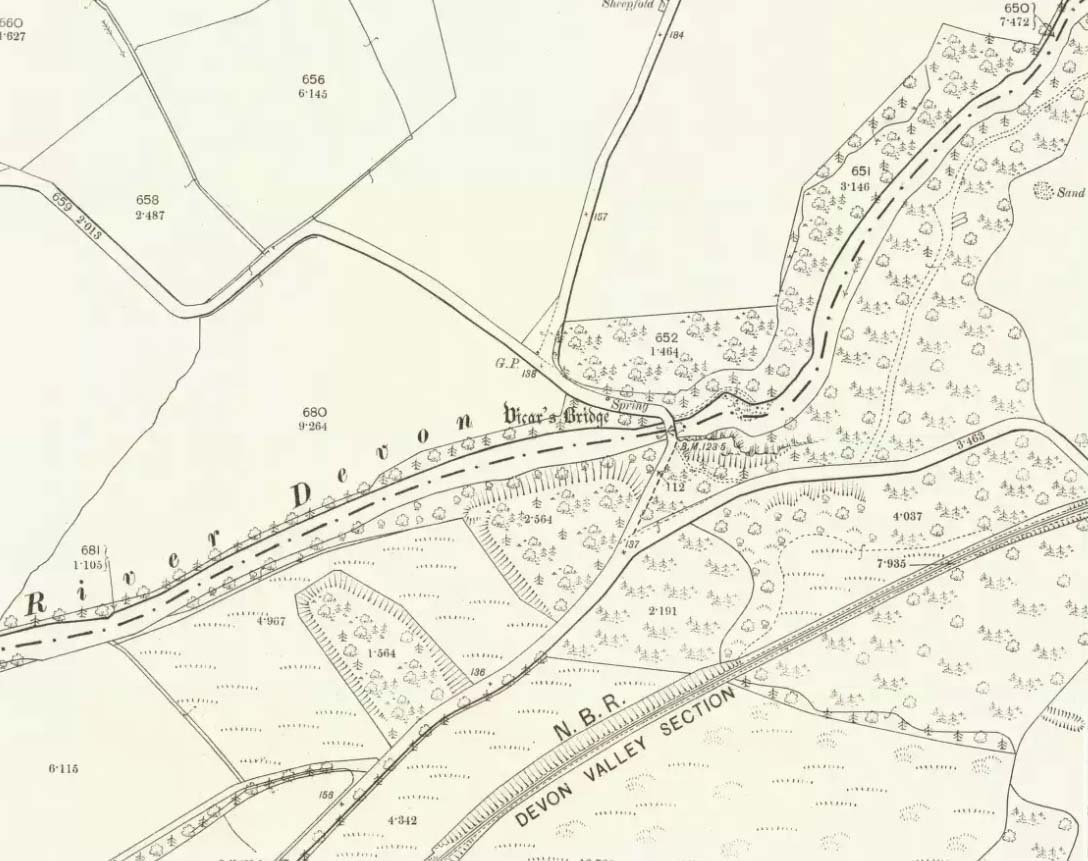
Somewhere hiding away above the north-side of the River Devon, just above the Vicar’s Bridge, a little-known healing well came into being following industrial workings in the glen in 1831 by a local iron-working company. The waters were strongly chalybeate, or iron-bearing—and as the fad amongst the wealthy was, at the time, a love of Spa Wells, this mineral spring was broadcast as a competitor of the Harrogate and Bath Spas. But it failed pretty fast, sadly.
Bottles of the water were marketed and sold as ‘Dollar Mineral Water’ in many of the large cities, but sales weren’t too good. Johnston & Tullis (2003) pointed out how the waters would have been coloured like brandy; and despite it being good for anaemia, a good tonic, and favourable in treating cuts and bruises, the mineral spring was no longer of any value as a business, dying a quick death. Local people still kept using the waters, but in recent years the spring appears to have died too.
References:
Johnston, Tom & Tullis, Ramsay (eds.), Muckhart, Clackmannanshire: An Illustrated History of the Parish, MGAS 2003.
The destruction of this site more than two hundred years ago almost beggars belief. It isn’t merely the fact that the self-righteous Industrialists did such things consistently, but that this particular tomb was more than just a few cartloads of stone being removed. The site would also have been completely lost to history were it not for the diligent research of local historian William Gibson (1883). In exploring the local place-names of the village, he asked the old locals as to “the origin of the name of Cairnpark in Dollar.” This is what he found:
“I have just learned, in the course of my present inquiries, that at the beginning of this century Dollar was possessed of an object of very great interest, but which unfortunately was entirely removed about the year 1806 or 1807. This was nothing less than a great pyramid (well, it was not quite so big as the famous one of Egypt, but still it was a great pile) which had evidently been erected to commemorate some great battle, or the death of some celebrated warrior; and it certainly is very much to be regretted that it should have been removed. This was an immense cairn of stones, some thirty feet high, and as many square at the base; and the park in which it stood took its name from it—Cairnpark; and the street leading up to the Academy also got its name—Cairnpark Street—from its being made through this park. It will scarcely be believed, yet it is nevertheless true, that this ancient and interesting cairn was removed for the ignoble purpose of being broken into road-metal for the new turnpike road that was then being constructed along the foot of the Ochils. By whose orders it was removed I cannot say; but the late Mr. William Blackwood, of the New Town, superintended its removal, and kept a correct note of the cart-loads that were in it, and found they amounted to the astonishing number of one thousand! (my emphasis, PB)
“When the bottom was reached, there were found in the centre of it a number of ancient clay urns, showing that this immense cairn was a thing of great antiquity, and connected with some important event, and, had it been allowed to remain, would have been an object of interest second only to Castle Campbell itself, and an additional attraction to the ancient town of Dollar. The Rev. Mr. Watson got possession of some of the urns, but what became of them is not now known.”
More than fifty years later, A.L. Drummond (1937) mentioned this old tomb, but could add no further details about it. Does anyone know what became of the burial remains? And how on earth could a giant tomb nearly 10 metres tall (Newgrange is 12m), consisting of 1000 cartloads of stone, be destroyed with barely any record of its existence? Astonishing!
Folklore
In a field south of the giant tomb, Gibson (1883) reported, “we used to have glorious ‘bonfires’ on the King’s birthday.” In Simpkins’ (1914) work, we read of an excess of witches nearby; and of a local giant responsible for creating parts of the landscape—akin to those we sometimes find attached to giant tombs—but nothing specifically relating to this tomb. Surely there must be remains of some traditions of this place, somewhere…?
References:
Drummond, A.L., “The Prehistory and Prehistoric Remains of the Hillfoots and Neighbouring District”, in Transactions Stirling Natural History & Antiquarian Society, volume 59, 1937.
Royal Commission on Ancient & Historical Monuments of Scotland, The Archaeological Sites and Monuments of Clackmannan District and Falkirk District, Edinburgh 1978.
Simpkins, John Ewart, County Folklore – volume VII: Examples of Printed Folk-Lore Concerning Fife, with some Notes on Clackmannan and Kinross-Shires, Folk-Lore Society: London 1914.
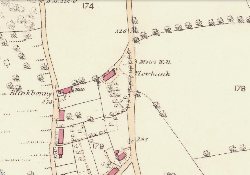
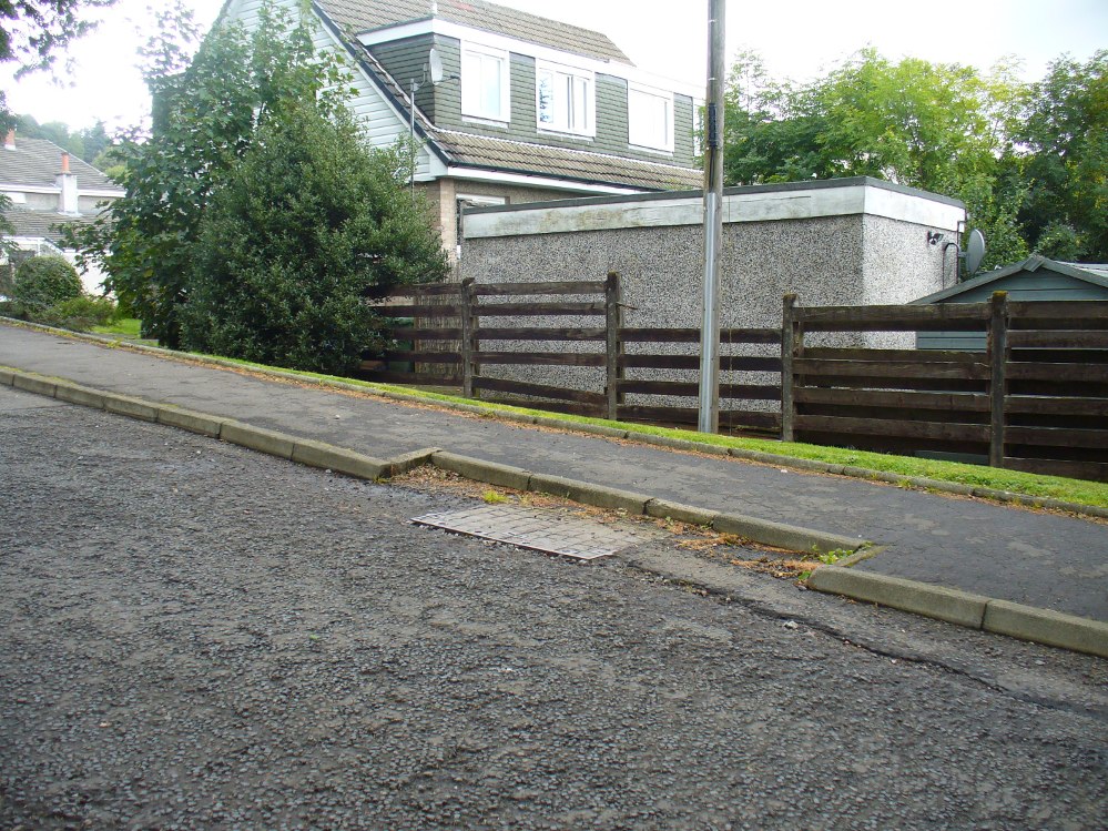
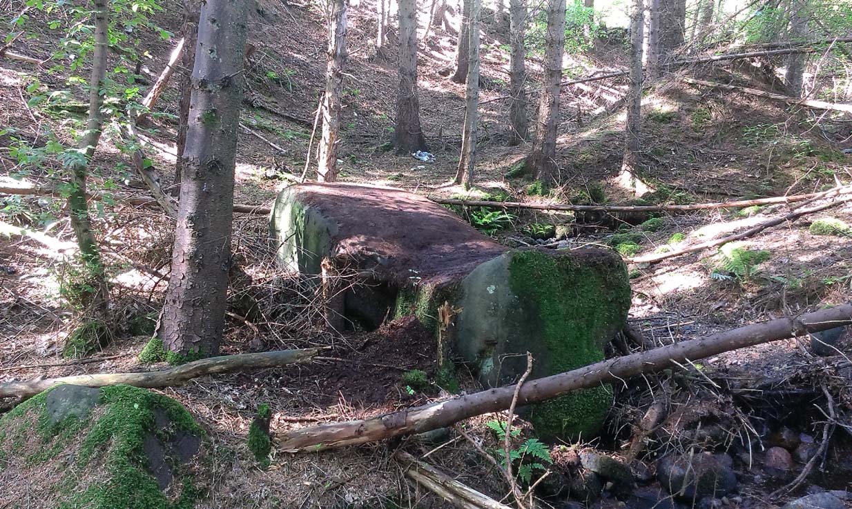
Go up the road alongside the Dollar Burn, turning right, up the steep hill as if heading to the Wizard’s Stone and the impressive Castleton monolith, a mile further along. Before reaching the Wizard’s Stone, keep your eyes peeled on the right for the street-name, ‘Moir’s Well’. From here, walk up the road less than another 100 yards and till you reach the water-cover.
Archaeology & History
Site of the old Muir’s Well
There is little known about any history of this now-covered old well, halfway up the steep slope towards Lochy Launds. It was noted by Ordnance Survey in 1861 and subsequently published on the earliest OS-map a few years later. It was obviously a wayside well for those venturing up the steep hill and used to have an old stone trough into which the waters ran. Although we don’t know for certain, the etymology of the well probably comes from the surname Muir, which according to William Gibson (1883) was common in the old village.
People living in the houses below here, told us that after heavy rains their gardens become very boggy, which is probably due to the sub-surface water from Muir’s Well. Tis good to know that the waters are still finding their way out!
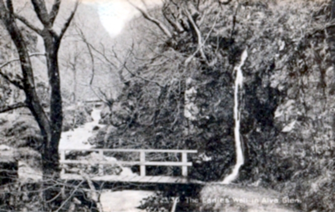
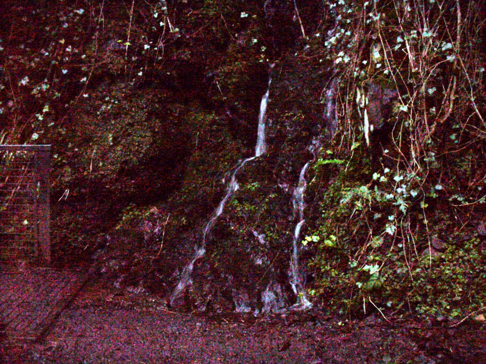
From Alva, take the signs to walk up the gorgeous Alva Glen gorge, past the site of the Dwarf’s Tomb, over the bridge past the first waterfall and up the footpath and into the glen proper. The path runs parallel with the gorge and a few hundred yards along you’ll reach a small footbridge. Immediately before this, on your right, coming down through the crags by the side of the path, the waters fall from the well in question. It’s easy enough to see.
Archaeology & History
Waters of the Lady Well on a dark, grey evening
The history of this site is seemingly hidden. Little has been written of it and its dedication to some ‘Lady’ is an oddity. I can find no specifics telling who the ‘lady’ in question is. The other Lady Well at Tillicoultry, a mile or two east, is equally bereft of historical certitude. Whether it is another dedication to the supposed ‘virgin’ Mary of the christian cult, or a local lady whose name has long since been forgotten, we do not know. Additional info on this site would be most helpful.
Shown on an early postcard of the Alva Glen and highlighted in Mr Pithie’s (1982) work, the waters here—running down the crag-face from a spring at the top—are fine, fresh and almost sweet-tasting, rich in minerals and healthy nutrients no doubt. Without doubt, I’d recommend a drink of this every time you walk past here! (apologies for the dark photo – I’ll get a better one next time we’re up there)
References:
Corbett, L., et al., The Ochil Hills, Forth Naturalist & Historian 1994.
Pithie, A., Views of Alloa and the Neighbourhood, Clackmannan District Libraries 1982.
Acknowledgements: Grateful thanks to Lisa Samson for help with directions.
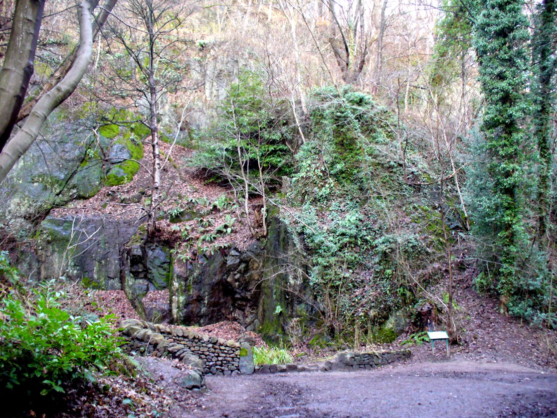
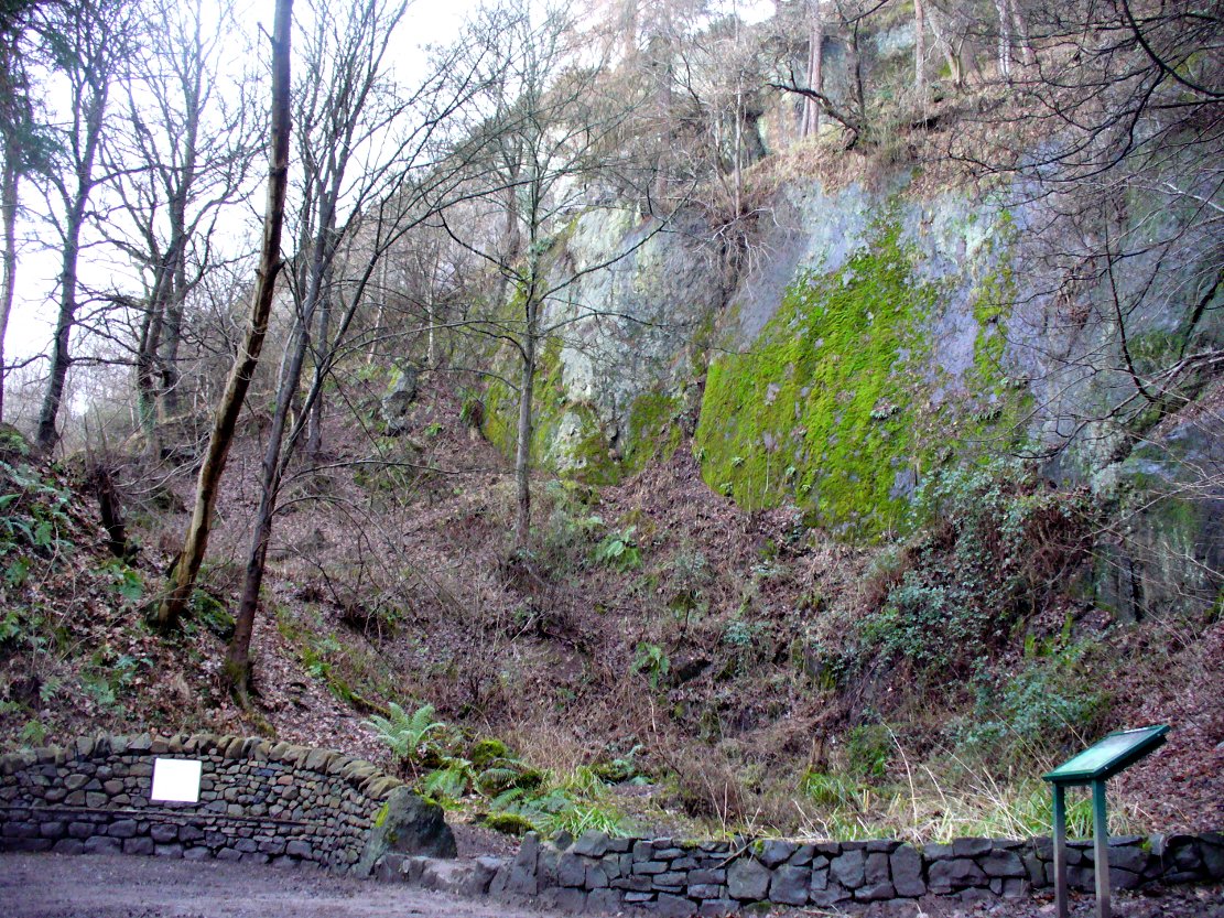
From the main street through Alva, between the Co-op and the corner shop, go up the small road at the side of the Johnstone Arms Hotel (Brook Street) and, at the small crossroads, straight across as if following the sign to the golf course. Stay along the track parallel with the Alva Burn waters and as you go into the trees a hundred yards or so along, to your left is a disused quarry, with a couple of plaques telling you its brief history. This is the spot!
Archaeology & History
This is a truly fascinating site for a number of reasons. Sadly, we can no longer see what had been here for oh so many thousands of years thanks, as usual, to the industrialists destroying the land here. Although in this case, without them we’d be unaware of its very existence. Additionally, there is a twist to the industrial’s find, which seems to have stopped further quarrying by some local people….
The tomb was somewhere in the left-middle
Listed in the relative Royal Commission accounts (1933; 1978), without comments, the tale is a simple one, but was narrated in some detail by J.G. Callander (1914) in Scotland’s prodigious Society of Antiquaries journal. During some quarrying operations over the Christmas period of 1912, James Murdoch “uncovered the remains of a human skeleton which had been buried in a natural cavity in the rock.” Three weeks later, local police officer George Donald and Dr W.L. Cunningham of Alva, accompanied Mr Callander to the site and made a detailed assessment of what had been found. He wrote:
“The quarry in which the grave was found is situated at the mouth of Alva Glen, a few yards distant from the right bank of the burn which flows through it. The body had been placed in a cavity or rock shelter in the face of the cliff, about 40 feet from the base, and about 200 feet above sea-level, and a rough, curved wall of dry-stone building, about 1 foot in thickness, had been built across the opening, which faced the east, the ends of the wall being still in situ when I visited the site. The space enclosed measured about 4 feet 6 inches from north to south, and about 5 feet from east to west. Subsequent to the burial the whole face of the rock and the walling had been covered, to a thickness of probably some 6 feet, by soil and detritus washed down from the hill face above. The greater part of the floor of the cavity was formed of clean, broken, angular stones, but the space on which the body was placed had been covered with a thin layer of soil preparatory to the burial. No charcoal or charred wood, which is so often seen in prehistoric graves, was found in this deposit. The skull lay in the north end of the grave, on its right side, facing the rock to the west, the vertebrae and ribs followed a line to the south, and the nether limbs were inclined towards the interior of the cavity. The whole face, including all the teeth and the lower jaw, was a-wanting. Apparently the body had been placed in a flexed position, half on its side and half on its back. Nothing else was found in the grave but a quantity of snail shells, probably twenty or thirty, which were nearly all broken, the few complete examples being in a very fragile condition.
“Elsewhere it has been stated that these formed a necklace, but while they were strewn out in front of the skeleton for a distance of over 3 feet, none of them showed any signs of artificial perforation. The species of Helixis is probably hortensis, the common garden snail.”
Mr Callander then included a lengthy description of the body itself, some of whose bones were fractured. He told that a certain
“Professor Bryce states that the skeleton is that of a dwarf of about 4 feet 2 inches in stature. The epiphyses are all fully united, although the line of union is visible on the surface at some points. Growth must therefore have been completed, and the person must have been, if the union of the epiphyses of the long bones had pursued its normal course, over twenty-one years of age…”
Regarding the sex of the dwarf, Mr Bryce wasn’t 100% certain, but told:
“The calvaria shows the general characters of a female skull, but it cannot be stated definitely that the individual was a woman, because the cranial characters are such as might have been present in a dwarf of the male sex. The calvaria is of moderate size, and is well formed.”
Bryce concluded as a whole that this person was in reasonably good health and, from the condition of the bones, showed “there was no evidence of the disease known as rickets.” In his final remarks he told:
“The general conclusions to which a careful examination of the skeleton leads, is that we have here to do, not with a representative of a dwarfish race, but with an individual who from premature union of the epiphyses was to a remarkable degree stunted in growth. The condition is a well-known one, and the class of dwarfs, in which this individual must be included, is well recognised.”
Probable spot of the lost tomb
The exact spot of the tomb appears to have been destroyed, or at the very least is certainly covered over and no longer visible. The section of the quarry looking east, into which the tomb was built, is all-but gone and no initial evidence prevails to show its exact location. However, it would seem from the description to have been close to the tops of the tree-line, perhaps giving a clear view to the rising sun in the east. Perhaps…
The position of this tomb, enclosed high up in the cliffs, hidden away at the entrance to the deeply cut ravine of the Alva Glen, is intriguing in that it is a rarity. Ravines like this are always peopled by olde spirits in animistic tribal traditions — and this dangerous glen with its fast waters and high falls would have been no different, especially to the Pictish people who we know were still here even after the Romans had buggered off. Is it possible that this figure was a guardian to the Glen itself, a medicine woman or shaman, whose very Glen was her home? We know from traditional accounts in many of the North American tribes that dwarves were accessories to the spirit worlds, and some were shamans. (Park 1938) In northern and central European lore, these small people are “the mysterious craftsmen-priests of early civilizations.” (Motz 1987) Whilst in Scottish lowland lore, the ‘Brown Man of the Muirs’ was a dwarfish creature described by Briggs (1979) as “a guardian spirit of wild beasts”, or watered-down shaman figure. There is more to this burial than meets the eye of dry academia…
Folklore
The Alva Glen—in addition to being beautiful and home to the Ladies Well—was long known to be one of many places in the Ochils that were peopled by the faerie folk. (Fergusson 1912) Local people still say this place is haunted by the spirit of a dangerous witch called Jenny Mutton.
It’s worth reiterating the words of Mr Callander (1914) regarding the finding and subsequent death of the man who uncovered this fascinating tomb, as some folk (then as now) think his demise was as inevitable as the man who planned on building turbines in Glen Cailleach:
“On the 24th December last, while quarrying stone for road metal in a quarry at the foot of the Ochils, at Alva, James Murdoch uncovered the remains of a human skeleton which had been buried in a natural cavity in the rock. Two days later he was killed at the same spot by the fall of a mass of overhanging rock, a tragic sequel, which not long ago would have been considered a judgement on him for disturbing the dead.”
References:
Briggs, Katherine M., A Dictionary of Fairies, Penguin: Harmondsworth 1979.
Corbett, L., et al., The Ochil Hills, Forth Naturalist & Historian 1994.
Drummond, A.L., “The Prehistory and Prehistoric Remains of the Hillfoots and Neighbouring District”, in Transactions Stirling Natural History & Antiquarian Society, volume 59, 1937.
Fergusson, R. Menzies, The Ochil Fairy Tales, David Nutt: London 1912.
Gimbutas, Marija, “Slavic Religion,” in Encyclopedia of Religion – volume 13 (editor M. Eliade), MacMillan: New York 1987.
Motz, Lotte, “Dvergar,” in Encyclopedia of Religion – volume 4 (editor M. Eliade), MacMillan: New York 1987.
Park, Willard Z., Shamanism in Western North America: A Study in Cultural Relationships, Evanston: Chicago 1938.
Royal Commission on the Ancient & Historical Monuments, Scotland, Inventory of Monuments and Constructions in the Counties of Fife, Kinross and Clackmannan, HMSO: Edinburgh 1933.
Royal Commission on the Ancient & Historical Monuments, Scotland, The Archaeological Sites and Monuments of Clackmannan District and Falkirk District, Society of Antiquaries of Scotland 1978.
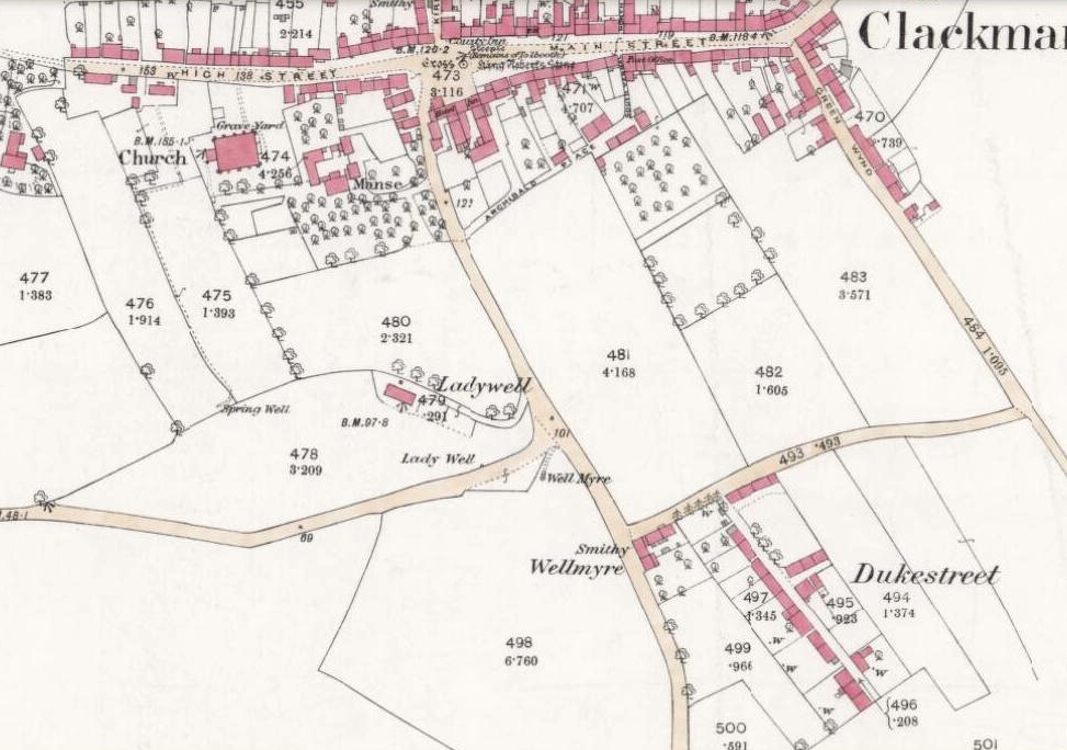
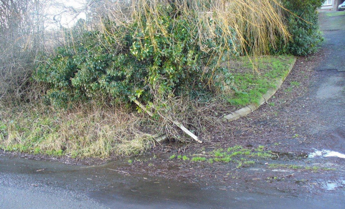
From Clackmannan village centre (with its huge phallic stone), at the crossroads take the south road, Port Street. Walk on here for 100 yards or so and the aptly named Ladywell Grove appears on the right. Walk past there and take the next right down Craigie Road. The original well was barely 50 yards along where the garden edges are today, within yards of the OS-grid ref; but walk another 100 yards down and, by the roadside is a waterworks cover.
Archaeology & History
Lady Well overflow?
One of at least three ‘Lady Wells’ that are known in tiny Clackmannanshire—and, like the others, it has not fared well. Not included in either of the major surveys (MacKinlay 1893; Morris 1981), nor referenced in the St. Bartholomew’s Day celebrations once held in the village. It is listed only in passing by Walker (1883) and Simpkins’ (1914) and I can find no references to it in the local history works. Yet it appears in differing place-name forms on the earliest Ordnance Survey maps and its name is still retained in streets-names here.
Whether this old spring of water was dedicated to St. Mary (as the majority of Lady Wells in Britain tend to be), or it was named after a local lady, history records seem quiet on the matter.
The original spot for the well (highlighted on the 1866 OS-map above) is covered in shrubs and seems to be gone. But another 100 yards down the road, a water-cover regularly overflows during heavy rains and this may be where its waters were diverted to.
References:
Simpkins, John Ewart, County Folklore – volume VII: Examples of Printed Folk-Lore Concerning Fife, with some Notes on Clackmannan and Kinross-Shires, Folk-Lore Society: London 1914.
Walker, J. Russel, “‘Holy Wells’ in Scotland,” in Proceedings of the Society of Antiquaries of Scotland, vol.17 (New Series, volume 5), 1883.
A few hundred yards below the legendary old Wizard’s Stone, we find there’s a real cluster of witch-lore in the small area to the north of Dollar which, to be honest, is deserving of wider analysis from competent researchers and historians. Not only is there the legendary Lochy Launds of the Black Goddess hereby, but we also find this curious rock, described by one ‘J.C.’ in an early edition of the Scottish Journal (1848), which told:
“On the confines of the parish of Dollar, not far from Hillfoot, the seat of John McArthur Moir, Esq., lies a glen, called Burngrens, watered by a small stream and planted with numerous large trees. A great number of these, however, have fallen, during the last few years, beneath the unsparing axe; but strong, healthy saplings are rising rapidly to supply their place.
“In this glen there is a large stone, of peculiar formation, in every way like a cradle. It is currently believed by the superstitious in the vicinity, that the stone, every Hallowe’en night, is raised from its place, and suspended in the air by some unseen agency, while “Old Sandy,” snugly seated upon it, is swung backwards and forwards by his adherents, the witches, until daylight warns them to decamp.
The following rather curious affair is told in connection with the “Cradle:”
“One Hallowe’en night a young man, who had partaken somewhat freely of the intoxicating cup, boasted before a few of his companions that he would, unaccompanied, visit the stone. Providing himself with a bottle, to keep his courage up, he accordingly set out. The distance not being great, he soon reached his destination. After a lusty pull at the bottle, he sat down upon the “Cradle,” boldly determined to dispute the right of possession, should his Satanic majesty appear to claim his seat. Every rustle of a leaf, as the wind moaned through the glen, seemed to our hero as announcing the approach of the enemy, and occasioned another application to fortifying “bauld John Barleycorn.” Overpowered at last by repeated potations, our hero, dreaming of “Auld Nick,” and his cohort of “rigwuddie hags,” fell sound asleep upon the stone.
“His companions, who had followed him, now came forward. With much shouting and noise, they laid hold of him, one by the head and another by the feet, and carrying him, half-awake, to the burn, dipped him repeatedly, accompanying each immersion with terrific yells. The poor fellow, thinking a whole legion of devils were about him, was almost frightened to death, and roared for mercy so piteously that his tormentors thought proper to desist. No sooner had our hero gained his feet than he rushed up the glen, and ran home, resolving never to drink more, or attempt such a feat again. For many a long day he was ignorant who his tormentors really were.
“We stood upon the stone about a week ago. Ivy and moss are slowly mantling over it, a proof that it is some considerable time since the Devil has been rocked on it.”
Historian Angus Watson (1995) told the place to be “south of Wizard’s Stone…near Kelty Burn,” and also that,
“it is said to be where witches rock Satan to sleep on Halloween.”
Above here, the tree-topped rounded hill to the north was one of the meeting places of the witches of Fife, Perthshire and Clackmannan. Something of sincere pre-christian ritual importance was undoubtedly enacted in this region, as we also find sites of the Maiden a short distance due north. Does anyone know more about this fascinating sounding place?
References:
‘J.C.,’ “The Deil’s Cradle”, in The Scottish Journal, February 5, T.G. Stevenson: Edinburgh 1848.
Simpkins, John Ewart, County Folklore – volume VII: Examples of Printed Folk-Lore Concerning Fife, with some Notes on Clackmannan and Kinross-Shires, Folk-Lore Society: London 1914.
Watson, Angus, The Ochils: Placenames, History, Tradition, PKDC: Perth 1995.
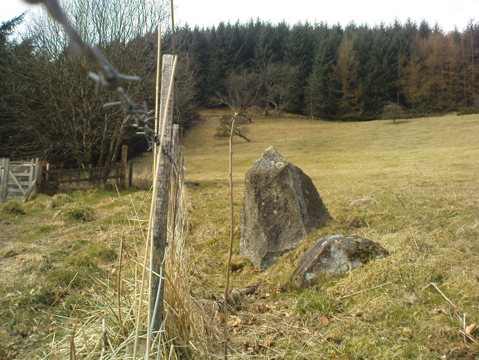
From Dollar town centre, take the road up to the gorgeous Castle Campbell, but instead of turning up towards the castle, keep on the road, uphill, for another quarter-mile. As the road begins to level out, a small field and driveway on your left heads up to Kiloran house. Stop here, and note the stone in the field, right by the fence alongside the footpath which runs uphill by the field-side up into the woods. That’s the Wizard’s Stone.
Archaeology & History
The Wizard’s Stone, Dollar
This site doesn’t seem to be the remains of an authentic prehistoric standing stone (unlike the one along the same ridge a mile east at Castleton), but is more of a memorial rock relating to some witch traisl that occurred here several centuries ago. By virtue of this, I felt it needed to be included on TNA.
Not listed by Canmore, the stone is found in an area with a rich cluster of heathen place-names—most intriguing of which is the ‘Lochy Launds’ woodland, right above where this Wizard’s Stone now rests. The stone has been broken into smaller pieces in recent years—as the photos here show—and the small standing stone which remains is barely 3 feet tall at the edge of the field.
The local writer and historian Rennie McOwan (1989) told that it marked the spot where a warlock was burned in the 16th century. Years later, a local land-owner called John Moir erected the stone here as a memorial to the event. This was subsequently echoed by fellow local history writer Bruce Baillie (1998), when he wrote:
“A large whinstone in a field in a field is known as ‘The Wizard’s Stone’, having been set there by one of the Moirs to take the place of a rotting stake said to mark the spot where the last Dollar witch (and, naturally, the last Scots one), named Forrester, was burnt, though this is probably folk confusion with the vicar of Dollar, Thomas Forrest.”
Angus Watson (1995) could find no early references of this stone, other than it being mentioned in the 1860 Ordnance Survey Name Book. Further information on the site would be most welcome.
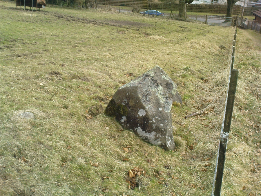
Folklore
Wizard’s Stone, looking down to the road
Reputedly one of the haunts and gathering places of the witches of the area, this spot was also known as Lochyfaulds, which the place-name giant W.J. Watson (1926) tell us means the ‘place of the Black Goddess,’ like the “Valley of the Black Goddess” of Glen Lochay, 40 miles to the northwest of here near Killin. Modern folklore ascribed the wizard here to have been Merlin—as highlighted in the adjacent place-name of “Merlin Park.”
References:
Baillie, Bruce, History of Dollar, DMT: Dollar 1998.
McOwan, Rennie, The Green Hills, CDL: Alloa 1989.
Watson, Angus, The Ochils: Placenames, History, Tradition, PKDL: Perth 1995.
Watson, W.J., The History of the Celtic Place-names of Scotland, Edinburgh 1926.
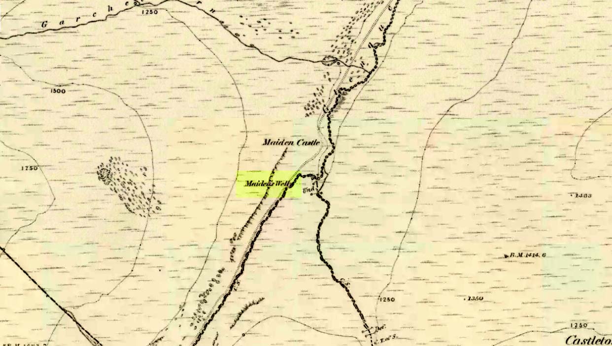
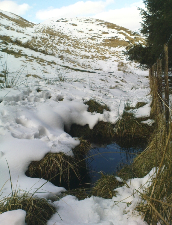
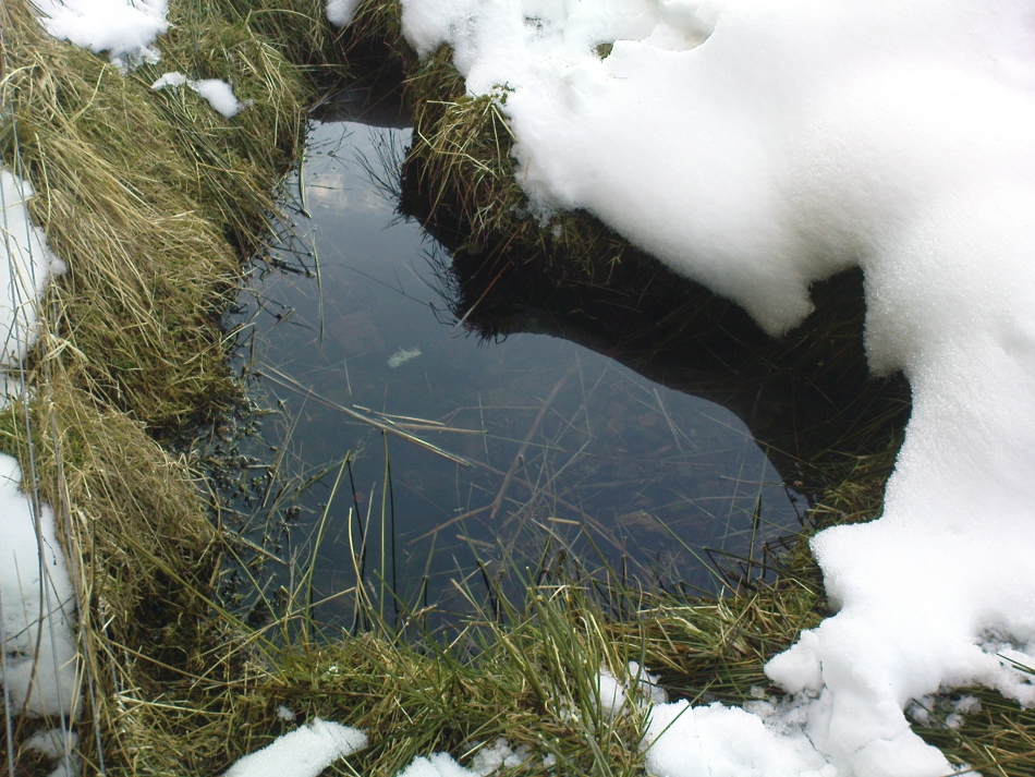
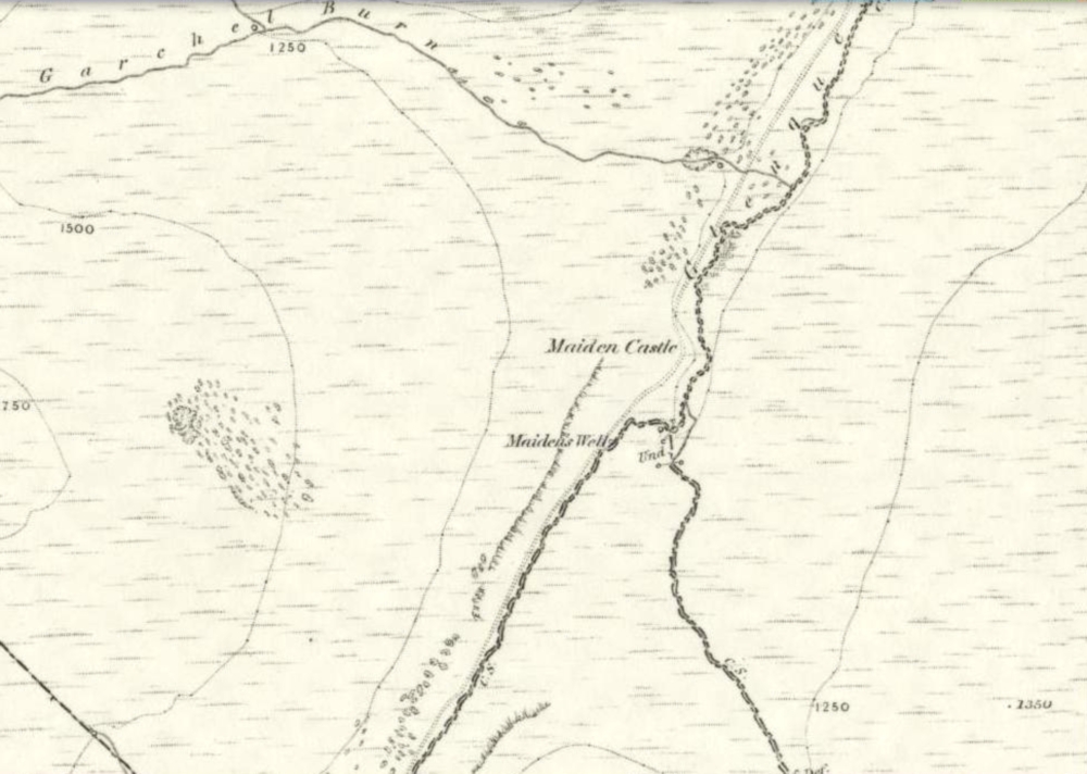
Follow the same directions as if you’re going to the Maiden Castle fairy hill. About 100 yards before reaching the hill, on the right-hand side of the footpath between the tree-line and the small stream, you’ll see a small pool of water. That is the Maiden’s Well.
Archaeology & History
Maiden’s Well & the fairy haunt of Maiden Castle hill behind
A mile northeast of the faerie-haunted Butter Well, just on the border of Clackmannanshire and Perthshire, we find this little-known magickal spring. More than a century ago, the story of this remote well was heard about hundreds of miles away by one Rev. Andrew Clark of Oxford, “who heard it from the late sexton of the parish of Dollar, in the county of Clackmannan” and who then mentioned its existence to the great Victorian Celtic scholar John Rhys (1901), who subsequently wrote of it as being “a fine spring bordered with flat stones, in the middle of a neat, turfy spot”, close to the legendary faerie hall of Maiden Castle. The well itself has now given birth to a pool whose waters, so folklore and text ascribe, always provides good clear water even in the height of summer.
The local historian Hugh Haliburton (1905) told that the well obtained its name from a princess who was held captive in Castle Campbell in the valley to the southwest, and that she was sometimes allowed out of prison by her captors, to walk to the well and drink its waters.
Folklore
This tale has been mentioned by various historians and, no doubt, has some religious relevance to the faerie lore of Maiden Castle, close by, Bruce Baillie (1998) told:
“A story associated with it states that it is haunted by the spirit of a beautiful maiden which only appears at night and, should any male attempt to kiss her, coronary thrombosis occurs.”!
The Maiden’s Well pool
Earlier accounts tell of magickal rites that could be used to invoke the beautiful maiden, but once again dire consequences may befall the poor practitioner.
To this day, local people visit the well and make offerings to the spirit of the waters, as you’ll see if you come here. Some of the remains here are very old; and a visit not long ago indicated that offerings were made even when surrounded by depths of snow in the middle of a freezing winter.
References:
Baillie, Bruce, History of Dollar, DMT: Dollar 1998.
Fergusson, R. Menzies, The Ochil Fairy Tales, Clackmannan District Libaries 1985.
1860 map showing Maiden Castle (and the Maiden’s Well)
Take the small steep road uphill from the town of Dollar in Clackmannanshire towards Castle Campbell. Less than 100 yards above the small parking spot by the small white house near the top of the hill, turn to walk up the footpath on your right above the house, following the edge of the depleted forestry plantation parallel with the valley. Cross the valley a few hundred yards up, but keep to path on the other side that stays parallel with the stream. You’ll hit a small rocky glen a half-mile up. Walk thru it, alongside the very edge of the forest till the trees break and there’s a gap in the hills. You’ve just walked past the Maiden’s Well and in front of you is a large natural rounded hill, which the footpath bends around. This hill is the Maiden Castle. (if you walk round this, a view into the eastern hills and a small lake opens up ahead of you)
Archaeology & History
The fairy hill of Maiden Castle
A large rounded hill marking the opening of Glenquey to the north and the Glen of Care to the south. Although ascribed in place-names old and new as a ‘castle’, there are no remains as such left here to account for this title. Angus Watson (1995) tells of the possibility of the place deriving its name from the Gaelic Creag Ingheann, or maiden crag. In Bruce Baillie’s (1998) survey of the area, in trying to give some relevance to the place-name, he points out that whilst no hillfort or cairn that might help account for the folklore (see below),
“Large-scale maps indicate a spot opposite on Hillfoot Hill as Greig’s Grave. There would seem to be something ancient here but of what nature it is, at the moment, impossible to say.”
When we visited the place yesterday, snow still covered much of the ground hereby, so we couldn’t do our usual explorations seeking for old sites (even the hut circles 100 yards away were covered over). The legendary healing waters of the Maiden’s Well are below here, by the side of the burn.
Folklore
This large rounded hillock was evidently a place of some importance in bygone days if the folktale here is anything to go by. Although the story echoes the some of the core sequences of modern ‘close encounter’ abduction events, other ingredients here tell of more arcane peasant rites that were once part of the social structure of our ancient heathen tribes:
“A piper, carrying his pipes, was crossing from Glendevon to Dollar in the grey of the evening. He crossed the Garchil (a little stream running into the Quaich), and looked at the Maiden Castle and saw only the grey hillside and heard only the wind soughing through the bent. But when he had passed beyond it, he suddenly heard a burst of lively music and turned round to look at what was causing it. And there, instead of the dark knoll which he had seen a few moments before, he beheld a great castle, with lights blaring from the windows, and heard the noise of dancing issuing from the open door. He went back somewhat incautiously to get a closer view, and a procession issuing at that moment from the Castle’s open door, he was caught up and taken into a great hall ablaze with lights, while people were dancing on the floor. He was at once asked to pipe to them and was forced to do so, but agreed to do so only for a day or two. At last getting anxious, because he knew his people would be wondering why he had not come back in the morning, as he had promised to do, he asked permission to return home. The faeries seemed to sympathise with his anxiety and promised to let him go if he played a favourite tune of his, which they seemed fond of, to their satisfaction. He played his very best. The dance went fast and furious, and at its close he was greeted with loud applause. On his release he found himself alone in the grey of the evening, beside the dark hillock, and no sound was heard save the purr of the burn and the soughing of the wind through the bent. Instead of completing his journey to Dollar, he walked hastily back to Glendevon in order to relieve his folk’s anxiety. He entered his father’s house and found no kent face there. On his protesting that he only gone away for a day or two before, and waxing loud in his bewildered talk, a grey old man was aroused from a doze beside the fire, and told how he had heard when a boy from his father that a piper had gone away to Dollar on a quiet evening, but had never been seen or heard since, nor any trace of him found. It turned out the piper had been in the ‘Castle’ for a hundred years.”
The Fortean experts John Keel (1971) and Jacques Vallee (1970) both contended, quite rightly, that some aspects of the ancient encounters related in such folklore has strong parallels to modern UFO ‘abduction’ events. In addition, Paul Devereux (1989) cites that such events occur where strong geomagnetic forces exist in proximity to rock outcrops, as found here.
There is the additional feature in these stories of the music of both faerie and pipers alike, whose revelling jigs carry the mortal out of time and, when returning back to human life, find no one recognises them. This is a condition of some rites of passage in traditional societies, where mothers and fathers no longer recognise their child after they have been through the rituals after visiting spirit-lands and returning as adults for the first time: an element in our faerie-lore that has been overlooked in assessing the nature of these fascinating tales.
References:
Baillie, Bruce, History of Dollar, DMT: Dollar 1998.
Devereux, Paul, Earthlights Revelations, Blandford: London 1989.
Fergusson, R. Menzies, The Ochil Fairy Tales, David Nutt 1912.
Keel, John A., UFOs: Operation Trojan Horse, Souvenir Press: London 1971.
Rhys, John, Celtic Folklore – Welsh and Manx: volume 1, Oxford University Press 1901.
Vallee, Jacques, Passport to Magonia: From Folklore to Flying Saucers, Tandem: London 1975.
Watson, Angus, The Ochils: Placenames, History, Tradition, PKDC: Perth 1995.