Up, round the back of Stirling University, between Bridge of Allan to Greenloaning, take the steep zigzaggy Sheriffmuir Road uphill, until it levels out beyond the main wooded area where the hills open up on either side of you. There’s a little touristy parking spot further along the road, just below a small wooded bit. Keep going on the road for another ¾-mile, until you reach a small scattered copse of trees on your left. At the top of this copse, walk onto the moor on your left (west), following the old walling for more than another 500 yards, where a scatter of old trees live by the wallside. As this bends back downhill, note the rounded hill less than 100 yards above you (north). Go to the top of it!
Archaeology & History
There are several cairns hereabouts; yet despite several visits here, we still haven’t got round to checking them all out, as other little-known archaeological remains keep catching our attention (old walled structures and a possible enclosure). This is the most notable one of the bunch in the region — and easiest to find thanks to it being on top of the small hill where, many years ago indeed, was laid this small round rocky tomb of some long-dead chief, or granny, or someone!
There’s not been much written about this cairn, or its companions (Pendreich 2 & 3). It was referred to in the Scottish Royal Commission inventory for Stirlingshire (1963) where it’s listed as site no.3 as ‘Cairn, Sheriffmuir Road’, but their description is scant. They wrote:
“On a low ridge 800 yards WSW of spot-level 776 on the Sheriffmuir Road, and at a height of 800ft OD, there is a round cairn measuring 40ft in diameter and 2ft 8in maximum height. For the most part it is covered with grass, but a shallow depression in the centre, which may have been caused by excavation, reveals a few boulders.”
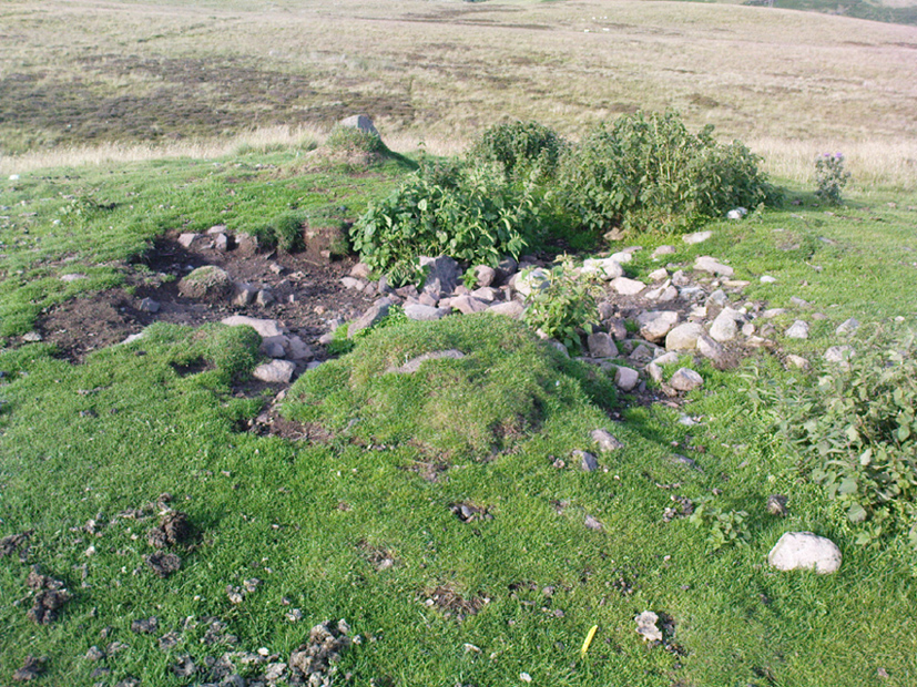
Pendreich cairn, looking westExposed section of cairn
Indeed! This cut into the centre of the cairn is somewhat larger than the 1963 description implies, as one of the images here shows. But the grassy mound is pretty clear and there’s certainly something buried beneath here.
The views from here are excellent and gave the spirits the usual panoramic flights across the land, as at many other ancient tombs. The great pyramidal hill of Dumyat rises to the east; and just a few hundred yards away to the north, we find the long laid-out standing stone of Pendreich Muir, whose mythic history has all-but been forgotten…
References:
Royal Commission on the Ancient & Historical Monuments Scotland, Stirling – volume 1, HMSO: Edinburgh 1963.
Carlie Craig is the tree- covered cliff, centre of photo
If you’re coming from Blairlogie, a half-mile west of the village, take the B998 road to the university, but turn right up the first road that runs uphill into the trees. But if you’re coming from Stirling or Bridge of Allan, keep your eyes peeled for the barely visible B998 at the crossroads and go up the hill, and along, for a good mile, below the Uni, past the factory, then up the small road on your left. Up this road go past the church another 100 yards and you’ll see the derelict ruins of Logie Kirk on your right. Right above the ruin you’ll see the tree-lined cliff immediately behind. This is the Carlie Craig!
Folklore
Carlie Craig on the 1862 map
The tree-covered Carlie Crags above the old ruined church and graveyard of Logie Kirk immediately below (thought to have been built in 1684) has long been associated with legends of old witches. Deriving its name from ‘carlin’, a witch or old woman (cailleach), the Crags were traditionally the place of heathen rites (authentic ones, not your plastic pagan types). In David Morris’ (1935) essay on the local township, he told the common story that “an elder in Logie Kirk was of the opinion that the Carla’ Craig…was haunted.” At the end of the 19th century, Morris remembered a local lady known as ‘Ailie’, who was said by many old folk to be the traditional “witch of Logie.”
“Sickly children were brought to her for her blessing. Occasionally people came from as far as Stirling on this errand. Her method of giving the blessing was to blow her breath on the child, and this was supposed to ward off evil. It was also said that anyone buried in Logie Kirkyard on the first day of May, Hallowe’en, or other days of that kind, without her blessing, would not rest in his grave…”
Another legend told that,
“around 1720 witches were believed to rendezvous with the Evil One (i.e. the devil) who would appear in the form of a large black dog.”
A lengthier account of the belief in witchcraft and animistic pre-christian rites above the crags was told by Charles Rogers (1853):
“About the second decade of last century, there lived in the parish of Logie several ill-favoured old women, to whom the reputation of witchcraft was confidently attached. They were believed to hold nocturnal dialogues and midnight revels with the Evil One, and Carlie Crag was regarded as one of their places of rendezvous. Satan, though he was believed to appear to them in various forms, was understood, in his interviews with the dreaded sisterhood, to appear most frequently in the aspect of a large shaggy dog, in which form it was alleged he had repeatedly been seen by the minister. An elder of the kirk had been returning of an evening from a shooting excursion among the hills, with a trusty musket, which he had picked up some years before on the field of Sheriffmuir, and discovering on the top of Carlie an animal realizing the description of the Satanic mastiff, resolved to try upon it the effects of a shot. He knelt down cautiously near the foot of the crag, and after ejaculating a short prayer, and slipping into his musket a silver coin, fired with trembling heart but steady aim. His victim, evidently shot dead, tumbled to the base, and the delighted and astonished elder lost no time in personally communicating to the minister the success of his wonderful adventure. Though not a little superstitious, the minister was somewhat sceptical as to the mysterious dog being really dead. He however agreed to accompany his elder next morning to the foot of the crag to inspect the carcase; but on reaching the spot, they found the remains of no shaggy dog or evil genius, but the lifeless form of the beautiful pet goat of a poor and aged woman, a much respected parishioner. The minister and elder both shed tears. The wicked dog still lived, the innocent goat had perished. The elder however took credit to himself for his good intentions and valorous intrepidity ; and the minister deemed it proper to improve the subject in his pulpit prelections on the following Sabbath. Discoursing on the subject of resistance to the Devil, he remarked, that the Evil One might assume numerous shapes and forms; that he went about as a roaring lion was declared in the Word, but he might take to himself various other aspects. He might even appear as a black colley dog.” But whatever form he may assume,” added the minister, ” he cannot be overcome or destroyed by powder and shot. There is a gun, however, that will shoot him, and it is this — it is the Bible. Shoot him then, every one of you, with this gun, and he shall be shot.”
Whether the vicar’s biblical superstitions were adopted by local people—who were so much more used to the living animism of landscape and natural cycles—is questionable. The crag is a fine site for ritual magick and its associative devil-lore probably derives from Pictish shamanistic practices, remains of which are evident across the Scottish hillls and northern England, where they survived for some considerable time…
References:
Morris, David, B., “Causewayhead a Hundred Years Ago”, in Transactions of the Stirling Natural History and Archaeological Society, 1935.
Roger, Charles, A Week at Bridge of Allan, Adam & Charles Black: Edinburgh 1853.
Watson, Angus, The Ochils – Placenames, History, Tradition, Perth & Kinross District Libraries 1995.
Various ways to get here. Probably the easiest is via the golf course itself, walking up towards the top where the trees reach the hills, but keeping your eyes peeled for the large archetypal tumulus or fairy mound near the top of the slope. Alternatively, come up through the wooded slopes from Bridge of Allan and onto the golf course, keeping your eyes ready for the self same mound sat in the corner by the walls. You can’t really miss it to be honest!
Archaeology & History
This is an impressive-looking burial mound sat, intact, on the edge of those painful golf courses that keep growing over our landscape — and you can see for miles from here! It would seem to have been placed with quite deliberate views across the landscape, reaching for countless miles into the Grampian mountains north and west across the moors of Gargunnock and Flanders towards Lomond and beyond…
Fairy Knowe, facing westSir Armstrong’s old drawing
The Fairy Knowe was first excavated in 1868 by Sir J.E. Alexander and his team, when their measurements found it to be some 80 yards in circumference, 78 feet across and 21 feet high — compared to less than 60 feet across and only 8 feet tall today. The findings were recorded in one of the early PSAS reports, and more recently a synopsis of the account was made of it by the Royal Commission (1963) lads who summarized his early findings and told:
“The excavation revealed a cist in the centre of the cairn, laid on the original surface of the ground and measuring 2ft 6in in length, 1ft 6in in breadth and 3ft in depth. Its walls were formed partly of upright slabs and partly of small stones laid horizontally, while the floor and the roof each consisted of a single slab. Within it there was a deposit, 6in in depth, of black earth, charcoal and fragments of human bone among which pieces of a skull were conspicuous. The cist was covered by a heap of large stones, 8ft in diameter and 13ft in height, and this in turn was covered with earth, in which there were charcoal, blackened stones, fragments of human and animal bones and unctuous black earth. Among these remains were found six flint arrowheads, a fragment of what was once thought to be a stone spear-head, and a piece of pine which, it was suggested, might have formed part of a spear-shaft.”
Also, near the top of the cairn in the fairy mound, Sir Alexander’s team located a prehistoric beaker vessel and fragments of what they thought were other beakers pots. Archaeologist Richard Feachem (1977) also mentioned this site in his gazetteer, simply copying the words of previous researchers.
Other prehistoric cairns can be found nearby: one in Cuparlaw Woods less a mile north; plus the Pendreich cairns on the edge of the moors just over 1 mile to the northeast.
Folklore
Obviously an abode of the faerie folk in bygone times, the tales of the place are sadly fading from local memory… Mr Alexander (1868) thought this place may have been an important site for the Pictish folk, and he may well have been correct, as the legendary hill of Dumyat (correctly known as Dun Myat) 2 miles east of here has long been regarded as an outpost of one Pictish tribe.
The main piece of folklore attached to this place relates to its very name and how it came about. In R.M. Menzies (1912) rare work on the folklore of the Ochils, he narrates the local tale that used to be spoken, which describes a procession here from the Fairy Well, just over a mile to the east. Whether this folktale relates to some long lost actual procession between the two sites, we don’t know for sure. Mr Menzies told:
“Once upon a time, when people took life more leisurely, and when the wee folk frequented the glens and hills of Scotland, there was one little fairy whose duty it was to look after certain wells renowned for their curative properties. This fairy was called Blue Jacket, and his favourite haunt was the Fairy Well on the Sheriffmuir Road, where the water was so pure and cool that nobody could pass along without taking a drink of the magic spring. A draught of this water would have such a refreshing effect that the drinker could go on his journey without feeling either thirsty or hungry. Many travellers who had refreshed themselves at the Fairy Well would bless the good little man who kept guard over its purity, and proceed upon their way dreaming of pleasant things all the day long.
“One warm day in June, a Highland drover from the Braes of Rannoch came along with a drove of Highland cattle, which he was taking to Falkirk Tryst, and feeling tired and thirsty he stopped at the Fairy Well, took a good drink of its limpid water, and sat down beside it to rest, while his cattle browsed nearby. The heat was very overpowering, and he fell into a dreamy sleep.
“As he lay enjoying his noonday siesta, Blue Jacket stepped out from among the brackens and approaching the wearied drover, asked him whence he came. The drover said:
“‘I come from the Highland hills beside the Moor of Rannoch; but I have never seen such a wee man as you before. Wha’ may you be?’
“‘Oh,’ said the fairy, ‘I am Blue Jacket, one of the wee folk!’
“‘Ay, ay man, ye have got a blue jacket, right enough; but I’ve never met ony o’ your kind before. Do ye bide here?’
“‘Sometimes; but I am the guardian of the spring from which you have just been drinking.’
“‘Weel, a’ I can say is that it is grand water; there is no’ the likes o’t frae this to Rannoch.’
“‘What’s your name?’ asked the fairy.
“‘They ca’ me Sandy Sinclair, the Piper o’ Rannoch,’ was the reply.
“‘Have you got your pipes?’ asked Blue Jacket.
“‘Aye, my mannie, here they are. Wad ye like a tune? Ye see there’s no’ a piper like me in a’ Perthshire.’
“‘Play away then,’ said Blue Jacket.
“Sandy Sinclair took up his pipes and, blowing up the bag, played a merry Highland reel. When he finished, he was greatly surprised to see above the well a crowd of little folk, like Blue Jacket, dancing to the music he had been playing. As he stopped they clapped their little hands and exclaimed, ‘Well done Sandy! You’re the piper we need.’
“Thereupon Blue Jacket blew a silver whistle, which he took from his belt, and all the wee folk formed themselves into a double row. Blue Jacket then took the Highland piper by the hand, led him to the front of the procession, and told him to play a march. Sandy felt himself unable to resist the command of the fairy, and, putting the chanter into his mouth, blew his hardest and played his best, marching at the head of the long line of little people, who tripped along, keeping time to the strains of the bagpipes. Blue Jacket walked in front of the piper, leading the way in the direction of the Fairy Knowe.
“Sandy Sinclair never marched so proudly as he did that day, and the road, though fairly long, seemed to be no distance at all; the music of the pibroch fired his blood and made him feel as if he was leading his clansmen to battle. When the Fairy Knowe was reached, the wee folk formed themselves into a circle round the little hill, and sang a song the sweetest that ever fell upon the ears of the Highlandman. Blue Jacket once more took his whistle and, blowing three times upon it, held up his hand, and immediately the side of the knoll opened. Bidding the piper to play on, Blue Jacket led the procession into the interior; and when all were inside, the fairies formed themselves into sets, and the piper playing a strathspey, they began dancing with might and main.
“One dance succeeded another, and still Sandy played on, the wee folk tripping it as merrily as ever. All thoughts of Sandy’s drove had gone quite out of his head, and all he thought of now was how best to keep the fairies dancing: he had never seen such nimble dancers, and every motion was so graceful and becoming as made him play his very best to keep the fun going. Sandy Sinclair was in Fairyland, and every other consideration was forgotten.
“Meanwhile his cattle and sheep were following their own sweet will, the only guardian left to take care of them being his collie dog. This faithful animal kept watch as well as he could, and wondered what had become of his master. Towards evening another drover came along with his cattle for the same tryst. He knew the dog at once, and began to pet the animal, saying at the same time, ‘Where’s your master, Oscar? What’s become o’ Sandy?’
“All the dog would do was to wag his bushy tail, and look up with a pleading air, as if to say, ‘I don’t know; will you not find him?’
“‘My puir wee doggie, I wonder what’s come over Sandy? It’s no like him to leave his cattle stravaiging by the roadside. Ay ay man; and at the Fairy Well too! Indeed, this looks unco bad.’
“The newcomer, who was also a Highlander, made up his mind to spend the night with his own drove and that of Sandy Sinclair, thinking that the missing man would turn up in the morning. But when the morning came there was no sign of Sandy.
“Taking Sandy’s collie and leaving his own dog in charge of the combined droves, he said, ‘Find master, Oscar!’ The wise beast sniffed around for a little and then trotted off in the direction taken the day before by Sandy Sinclair and the fairies. By and by they reached the Fairy Knowe; but there was nobody there as far as the drover could see. The dog ran round and round the knoll, barking vigorously all the time, and looking up into the face of the drover as if to say, ‘This is where he is; this is where he is.’ The drover examined every bit of the Fairy Knowe, but there was no trace of Sandy Sinclair. As the drover sat upon the top of the Fairy Knowe, wondering what he should do next, he seemed to hear the sound of distant music. Telling the faithful dog to keep quiet, he listened attentively, and by-and-by made out the sound of the pibroch; but whether it was at a long distance or not, he could not be certain. In the meantime, the dog began to scrape at the side of the mound and whimper in a plaintive manner. Noticing this, the drover put his ear to the ground and listened. There could be no mistake this time: the music of the pibroch came from the centre of the Fairy Knowe.
“‘Bless my soul!’ exclaimed Sandy’s friend. ‘He’s been enticed by the fairies to pipe at their dances. We’ll ne’er see Sandy Sinclair again.’
“It was as true as he said. The Piper of Rannoch never returned to the friends he knew, and the lads and lasses had to get another piper to play their dance music when they wished to spend a happy evening by the shore of the loch. Long, long afterwards, the passers-by often heard the sound of pipe music, muffled and far away, coming from the Fairy Knowe; but the hidden piper was never seen. When long absent friends returned to Rannoch and enquired about Sandy Sinclair, they were told that he had gone to be piper to the wee folk and had never come home again.”
The huge Pendreich Muir monolith, with Dumyat in the background
Nearly 600 yards west of the old Sheriffmuir Road (between Bridge of Allan to Greenloaning), you’re best approaching it up the zigzaggy lane from above Stirling Uni until it levels out beyond the main wooded area where the hills open up on either side of you. There’s a little touristy parking spot further along the road, just below a small wooded bit. Go past this and look out for the small peaked hill nearly a half-mile NW on your left. Take whichever footpath you fancy (if you see one) and get to the top of that hill!
Archaeology & History
This is a wonderful spot, located at the highest point on this small moorland region on the western edge of the Ochil Hills. I haven’t found too much written about this once proud, but now fallen monolith — which seems unusual considering its size, cos it’s huge! It would have stood out and been visible for miles around. Quite when it was felled, I cannot find. The only info I’ve got here (Royal Commission 1963) tells:
“Lying recumbent on a grassy patch among the heather, it is a four-sided pillar measuring 13ft in length, a maximum of 4ft 6in across the wider side, and a maximum of 1ft 6in across the narrower side.”
In enquiring about the nature of this stone a few years ago, a local chap who called himself ‘Wharryburn’ wrote to say, “I believe the laid-out stone is a fallen standing stone. My grandfather was gamekeeper at Airthrey Estate and responsible for the shooting on the moor there he passed it to my father etc… It’s the local volcanic stone, not an ice-dropped erratic. There are also a few biggish stones at points around that I tried to make some sense out of a few years ago, but no luck.”
The great hill of Dumyat rises to its east; a short distance north is a megalithic stone row with its upright Wallace Stone; whilst the overgrown prehistoric cairns of Pendreich 1, 2 and 3 live on the small hillocks a few hundred yards to the south.
References:
Royal Commission on the Ancient & Historical Monuments of Scotland, Stirlingshire – volume 1, HMSO: Edinburgh 1963.
From Dunblane Cathedral walk straight down town along High Street, but where the road bends to cross the river, keep to your left and onto the dual carriageway. Walk straight across and along the “private” drive that leads to Kippencross House. The first 100 yards is wooded either side of you, but when you come out into the grassy open, walk on for another 100 yards or so, keeping your eyes peeled for the rise in the grassland on your right, topped with a clump of trees. This is the cairn!
Archaeology & History
This is a lovely site, perched near the crown of a small hillock, surmounted with a crown of pinus trees that would have delighted Alfred Watkins and his ley-hunters. It is a veritable faerie mound, seemingly alone amidst this modernised but well-kept gardenscape. The large tomb sits upon a small rise in the land here, where the grasslands fall to its west and northern sides with some obvious deliberation.
Kerbstones on south side
The cairn doesn’t appear to have been excavated (but I don’t have my library to hand, so could be wrong – I’ll check when I get back home) and though there’s a distinct impression of cup-marked stones close by, we couldn’t find owt in our brief bimble here. The tomb measures about 20 yards across, and rises perhaps six feet or more above the ground level. Although a little overgrown with summer herbage (mainly Urtica and friends), quite a few small stones were visible close to the surface on different parts of the mound, looking like typical cairn material; though around its mainly southern edge is a line of larger kerb stones showing the outline of what would seem to be the edge of the monument.
The cairn is definitely worth having a look at if you’re in the area. It’s certainly a beautiful little spot to sit for a while…
References:
Royal Commission on the Ancient & Historical Monuments Scotland, Stirling – volume 1, HMSO: Edinburgh 1963.
Royal Commission on the Ancient & Historical Monuments of Scotland, Archaeological Sites and Monuments of Stirling District, Central Region, Society of Antiquaries of Scotland 1979.
From Dunblane, head up the Glen Road for nearly a mile, turning left up the Sheriffmuir Road and all the wya on till you reach the pub near the T-junction another couple of miles on. OK – get thru the gate and onto the moor, roughly in a straight line with the pub behind you for about 400 yards. You’re damn close! (if you find the nice standing stone known as the Wallace Stone, walk 250 yards southwest from here).
Archaeology & History
Almost nothing has been written of this cup-marked stone, found at the southern end of what’s alleged to be an authentic megalithic stone row alignment, running northeast to southwest — although this alignment isn’t included in either Aubrey Burl’s (1993) or Alexander Thom’s (1990) textbooks dealing with such matters.
Cup-marks highlighted in ice!Cup-marked rock with the Wallace Stone in the distance
When we came here last winter in temperatures of around -6°C (one helluva good day!), curiously only this and the other stones along this “stone row” were actually uncovered on the moorland. Quite bizarre to be honest! Many of the other rocks scattering this small moorland edge were covered in several feet of snow. We were lucky I s’ppose…though I’ve gotta get back up here again shortly and see the site in summertime (midges up mi crotch, cleggs-a-biting – oh such joy!) cos I can’t believe this is the only cup-marked stone hereby.
The rock itself is more than seven-feet long and has at least twenty archetypal cups carved into its slightly-slanting face — although when we visited the stone, several of these were difficult to see and, as the images show, even more difficult to photograph (of the 20 I took of this stone alone, only one was of any value in highlight the cups) . The stone gave the impression that it may have stood upright in the not-too-distant past — which would of course give the notion of this as part of megalithic avenue a considerably more potent status.
Some dood alleged that this potential stone row, with this cup-marked stone at its southwestern end, marked an astronomical alignment — but for the life of me I can’t remember who it was! (it’s my age creeping up on me at last!)
References:
Burl, Aubrey, From Carnac to Callanish: The Prehistoric Stone Rows and Avenues of Britain, Ireland and Brittany, Yale University Press 1993.
Heggie, Douglas C., Megalithic science: ancient mathematics and astronomy in north-west Europe, Thames & Hudson: London 1981.
Thom, A., Thom, A.S. & Burl, Aubrey, Stone Rows and Standing Stones – 2 volumes, B.A.R.: Oxford 1990.
Dead easy to find! From Stirling head out on the A9 road towards Bridge of Allan and Stirling Uni. You’ll hit a small roundabout a mile out of Stirling – go straight across and up the little bendy road. Follow this round the bottom side of the Uni for a half-mile, watching out for the left-turn as the tree-line ends, taking you up to the factory behind the trees (if you hit the roundabout a bit further on, you’ve gone too far!). Go up the slope and onto the level sports playing fields – where this old beauty will catch your eye! If you somehow miss it, just get to the Uni and ask some of the students where it is!
Archaeology & History
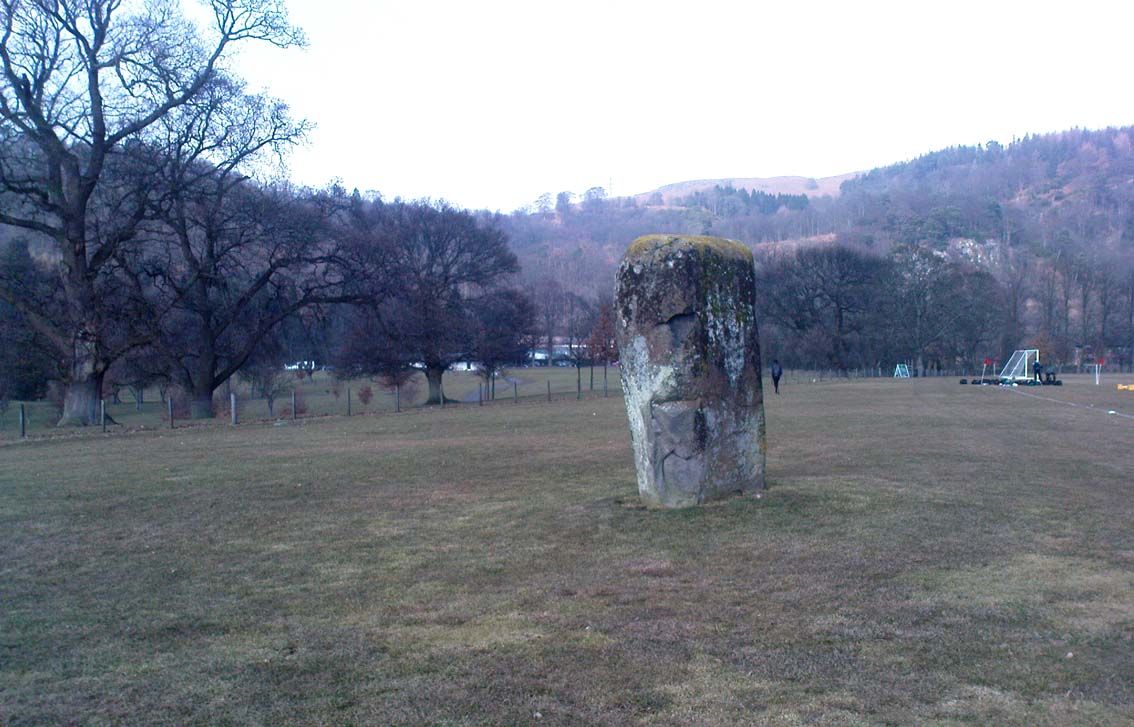
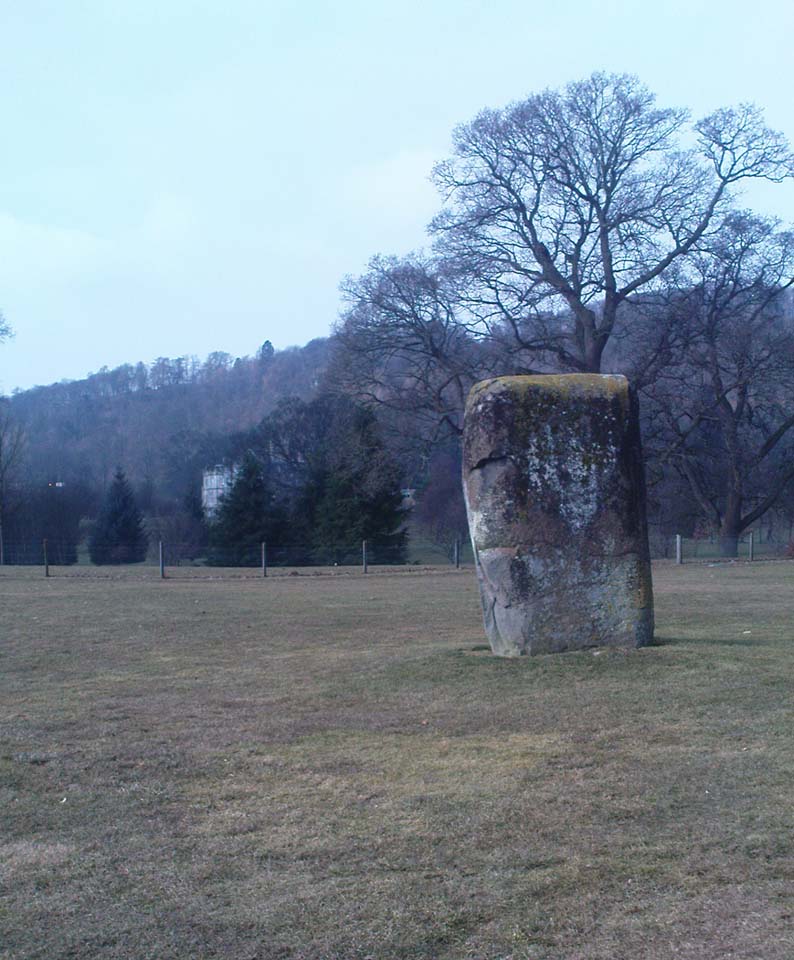
Airthrey Stone, looking NW
This single standing stone is a beauty! It’s big – it’s hard – and it’s bound to get you going! (assuming you’re into megaliths that is) Standing proud and upright on the eastern fields of the Stirling University campus, A.F. Hutchinson (1893) measured it as being “9ft 1in in height. Its greatest breadth is 4ft 10in, and its circumference 14ft.” A bittova big lad! More than fifty years later when the Royal Commission (1963) lads got round to measuring its vital statistics, only an inch of the upright had been eaten by the ground. The stone was highlighted on the earliest OS-maps of the area.
Folklore
Of the potential folklore here, most pens and voices seem quiet; although Mr Hutchinson (1897) told of William Nimmo’s early thoughts, linking the history of this stone with the others nearby, saying:
“Of what events these stones are monuments can not with certainty be determined. In the ninth century, Kenneth II, assembled the Scottish army in the neighbourhood of Stirling, in order to avenge the death of Alpin his father, taken prisoner and murdered by the Picts. Before they had time to march from the place of rendezvous, they were attacked by the Picts… As the castle and town of Stirling were at that date in the hands of the Picts, the rendezvous of Kenneth’s army and the battle must have been on the north side of the river; and as every circumstance of that action leads us to conclude that it happened near the spot where these stones stand, we are strongly inclined to consider them as monuments of it. The conjecture, too, is further confirmed from a tract of ground in the neighbourhood which, from time immemorial, hath gone by the name of Cambuskenneth: that is, the field or creek of Kenneth.”
And although this hypothesis is somewhat improbable, it was reiterated in the new Statistical Account of 1845, which also suggested that this and the other Pathfoot Stone were “intended probably to commemorate some battle or event long since forgotten.”
References:
Hutchinson, A.F., “The Standing Stones of Stirling District,” in The Stirling Antiquary, volume 1, 1893.
Royal Commission on the Ancient & Historical Monuments Scotland, Stirling – volume 1, HMSO: Edinburgh 1963.
Standing Stone (destroyed?): OS Grid Reference – NS 805 958
Archaeology & History
Nearly a hundred years ago Christina Buchan told the local writer Donald Morris (1935) about this seemingly forgotten and lost megalithic site. The narrative she gave told:
“I remember a stone which was known among the Causewayhead people as the Bel Stane. (The name is significant) It originally stood in the Doocot Park on Spittal Farm. This park overlooks the high road from Causewayhead to Bridge of Allan and adjoins the steading of Spittal… When the road leading up through the village of Causewayhead was formed (about 1820), the garden of William Robb’s cottage near the foot of the Broad Loan was somewhat altered in shape. He put up a new gate and, requiring a gatepost, he lifted the Bel Stane from Doocot Park and set it up at the front of his own house to support the gate. It was a stone of pillar-shape and stood four or five feet above the ground, and I do not remember whether they were any markings on it. The cottage became ruinous many years ago and the garden ran waste. A new house is now built on the site, but the Bel Stane has been lost.”
There is a possible contender for the lost Bel Stane, used again as another gatepost, on the south-side of the road some 450 yards to the east (at NS 80922 95931). The stone in question is somewhat fatter than usual gateposts, about four-feet tall, and has the eroded appearance of considerably greater age than many others. The monolith isn’t mentioned in the Royal Commission’s Stirlingshire inventory. Further information would be very welcome.
References:
Morris, David, B., ‘Causewayhead a Hundred Years Ago’, in Transactions of the Stirling Natural History and Archaeological Society, 1935.
Not too troublesome to locate really… It’s at the top-end of the University, just above the side of the small Hermitage Road, about 100 yards along. Keep your eyes peeled to your left!
Archaeology & History
Pathfoot Stone
Today standing proud and upright, this ruinous standing stone has been knocked about in the last couple of hundred years. Although we can clearly see that it’s been “fixed” in its present condition, standing more than 10 feet high, when the Royal Commission lads came here in August 1952 (as they reported in their utterly spiffing Stirlingshire (1963) inventory), it wasn’t quite as healthy back. They reported:
“Many years ago the stone, which is of dark grey dolerite, fell down and was broken, and the basal portion, now re-erected, is only 3ft 10in high; two large fragments however, still lie beside the base, and the original stone is said to have stood to a height of 9ft 4in. Of a more or less oblong section throughout, the re-erected stones measures 2ft 10in by 1ft 10in at ground level, swells to its greatest dimensions (3ft 2 in by 1ft 9in) at a height of 1ft 4in, and diminishes at the top…”
…and again!
But the scenario got even worse, cos after the Royal Commission boys had measured it up and did their report, it was completely removed! Thankfully, following pressure from themselves and the help of the usual locals, the stone was stood back upright in the position we can see it today. And — fingers crossed — long may it stay here!
Folklore
Commemorative plaque!
A plaque that accompanies the monolith tells that the old village of Pathfoot itself was actually “built around this standing stone” — which sounds more like it was the ‘centre’ or focus of the old place. An omphalos perhaps? The additional piece of lore described in Menzies (1905) work, that an annual cattle fair was held here, indicates it as an ancient site of trade, as well as a possible gathering stone: folklore that we find is attributed to another standing stone nearby.
Hutchinson, A.F., “The Standing Stones of Stirling District,” in The Stirling Antiquary, volume 1, 1893.
Hutchinson, A.F., “The Standing Stones and other Rude Monuments of Stirling District,” in Transactions of the Stirling Natural History and Antiquarian Society, 1893.
Royal Commission on the Ancient and Historical Monuments of Scotland, Stirlingshire – volume 1, HMSO: Edinburgh 1963.