There’s no footpath to this site, but we came to it via the car park on Coolham Lane on the southeast side of Earby. Walking uphill, we got over the wooden stile on the moorside and walked up the side of the walling, all the way upwards till we reached the top of the moor. You’ll pass the large Bleara Moor tumulus just by the walling, then head towards the rounded hillock on the top of the moor a coupla hundred yards away. Y’ can’t really miss it!
Archaeology & History
As with many sites in this area, very little has been said of this usually overgrown Bronze Age burial mound. Although no known recorded excavation of the tomb has ever been done, someone dug into the top of the mound in the 1960s, but we have no record of any finds. The tomb stands on the local boundary line between Earby and Lothersdale to the east and was known as ‘Bleara Haugh’ in the 1819 Enclosure Act. But little else has ever been said of it.
Bleara LoweOS-map of site
When we visited the place a few months ago, we were fortunate in that the heather had been burnt back, so allowing a much better view of the site than normally afforded when it’s covered in heather. The rounded mound was between 4 and 5 feet high and measured approximately 20 yards across. The pit which had been dug into the top of the mound was still visible, though much overgrown. The view from the tomb itself was very impressive — which would have been of some importance in the construction of the place. The Pastscape website describes Bleara Lowe as:
“A slightly oval mound of peat and heather-covered stones up to 1.4m high with max dimensions of 21m E-W x 19m N-S. There is a rectangular hollow 3m x 1.5m x 0.4m deep on the cairn’s summit.”
Another larger tumulus or overgrown cairn can be found over 200 yards west of here; plus a number of small singular prehistoric cairns have been located further down the western slope of the moor, known as the Bleara Moor Cairnfield. None of these sites have ever been excavated.
This once-impressive Bronze Age tomb is now much denuded and stands besides the legendary Fleam Dyke. The name of Mutlow was first used to describe this site in the 1812 Enclosure Act and means, literally, an “Assembly Hill” or Assembly burial mound. Reaney (1943) told that it was situated “at the junction of the boundaries of Great Wilbraham (Staine Hundred), West Wratting and Balsham (Radfield Hundred) and Fulbourn (Flendish Hundred)”, and was obviously an important moot spot where local tribal and council laws were made.
The great Cambridge archaeologist, Tom Lethbridge (1957) briefly described the place in his fascinating survey of the nearby hill-figures, Gog and Magog, saying:
“The hill itself is a Bronze Age barrow which was dug by the Hon. R.C. Neville about a hundred years ago. In it were, amongst other things, glass beads brought to Britain from the eastern Mediterranean in the fifteenth century before the birth of Christ. The barrow, which was presumably the site of a moot in Saxon times, seem to have been used as a sighting point for the construction of the Fleam Dyke… A circular Roman building, either a temple, or possible a signal station, stood close to Mutlow Hill.”
Lethbridge pointed out that another lesser-known trackway — “known in Saxon times as ‘the Street'” — also passed here, saying:
“When the land is ploughed and the light is right, you can see the numerous dark lines on the soil, all converging on Mutlow Hill. These are the old hollow ways of the Icknield Way and the Street.”
Folklore
One legend here speaks of a golden chariot that is reputedly buried either inside, or near to the old tumulus. Lethbridge (1957) again told of hearing this tale, though narrated, “it was said to be buried in Fleam Dyke near Mutlow Hill.” When he asked a local lady about the tale,
“She replied that she had always heard that it was not in the dyke itself, but in the road which passed the dyke and went on to West Wratting and the southeast.”
References:
Lethbridge, T.C., GogMagog: The Buried Gods, RKP: London 1957.
Reaney, P.N., The Place-Names of Cambridgeshire and Isle of Ely, Cambridge University Press 1943.
Just over the county boundary on the north side of the Wharfe’s riverbank, the easiest way to find this is from the village of Burley-in-Wharfedale, walking out as if heading towards Ilkley (west) and, just 100 yards or so before reaching the A65(T) road, walk down the footpath that takes you down to the River Wharfe. Go over the large stepping-stones and, once on the other side, walk down the edge of the riverbank for 10 yards, up the first ridge and there, just below the grass where the edge of the land is coming away, you’ll find this small cup-marking.
Archaeology & History
First discovered t’other day, on Friday, 28 May, 2010, when we were starting on another wander onto the hills. We’d only just crossed the large stepping-stones over the River Wharfe just outside Burley and heading up to Askwith, when Michala Potts stopped, peered and said summat along the lines of, “Errr….look at this!”
Riverbank Cup-MarkingClose-up of cup-mark
My initial thought was it was gonna be some naturally eroded water-worn stone — but it didn’t seem that way. Peering out from the edge of the ground n the company of many other small stones and gravel, which was slowly coming away just yards above the edge of the river, a rounded cup-marked stone with just a single cup-mark stood out like a sore thumb! It was covered in dusty earth and looked a quite decent example; but once we’d cleared the dried earth away and wet the stone, the cup-marking was truly enhanced. To those of you who have a thing about cup-markings and associations with rivers and streams, this one can be added to your statistics! (20 yards away the Askwith East Beck meets with the river)
Obviously added as part of the river embankment, the stone would obviously have been taken from a nearby source, but we’re unlikely to ever find out where. It looks typical of cup-marked stones that were added to cairns, but no such site (that we know of) occurred close by. We were gonna peel some of the embankment back and see if there was anything else here, but time and another ancient site that we’d arranged to see was calling us away, so we just got a few pictures and kept on our way…
Get to Widdop reservoir in the hills west of Hebden Bridge and park up. The great rock faces to your right (north) is where you’re going. Clamber to the top until the moor levels out, making sure you head NNW for less than a mile. The moors you’re now on are supposed to be private – but folk like me pay no attention! There are no footpaths to this great outcrop, only the heathlands and scattered stones – but keep walking for a half-mile north and you’ll get to them!
Archaeology & History
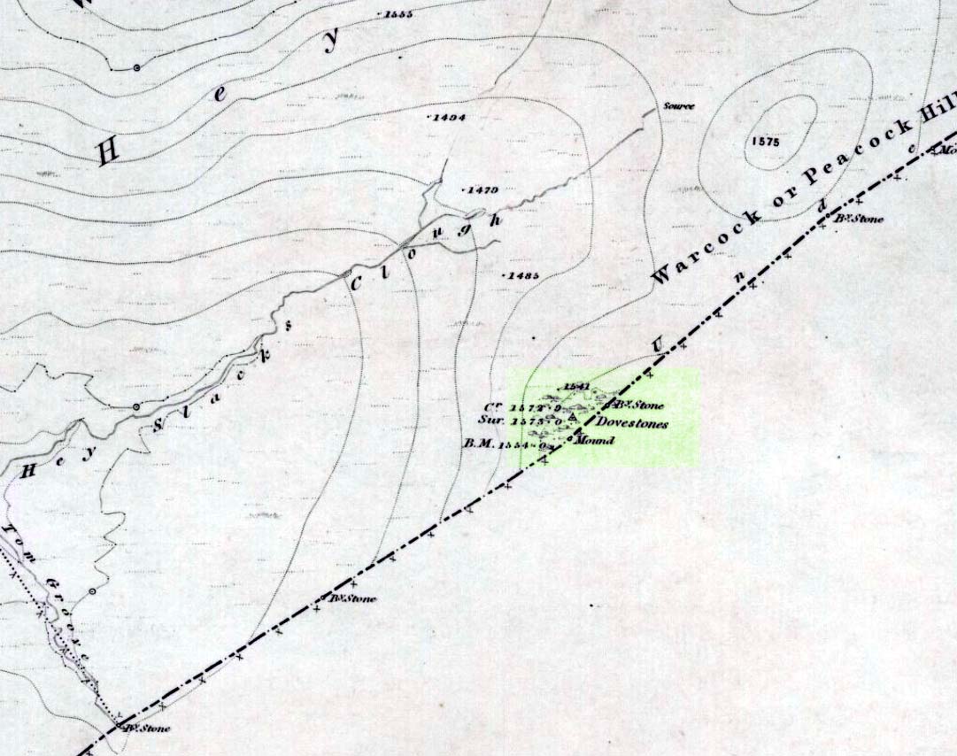
Erroneously ascribed by the place-name masters Eilert Ekwall and A.H. Smith (1961) as being ‘a place where doves gathered,’ this gigantic rock outcrop on the Yorkshire-Lancashire border — as shown on early maps — is actually the Dew or Black Stones (from the Gaelic, dubh). It’s an awesome place! Takes a bitta getting to, but it’s well worth the venture.
Dove Stones on 1848 map
This long geological ridge, rising higher as you walk along it to the north, has the occasional cup-mark on it, with the giant Dove Stone at the very end having a cup-and-half-ring on its crown (be careful not to fall off). From here, you look across a huge, desolate, U-shaped valley, the far side of which we rise to 1700 feet and the grand setting of the Lad Law.
Folklore
The folklorists Harland and Wilkinson (1882) included this in their survey of druidical sites, mentioning the several cup-markings, or druid basins as they called them. (though most of ’em on here are Nature’s handiwork)
For me, this is an incredible place – full of raw power and magick. It has a curious geomantic relationship with the Whinberry Stones, a couple of miles to the south, around which should be a ring of stones…though none can be found.
Stone Circle (destroyed): OS Grid Reference – SE 426 099
Archaeology & History
On the southern outskirts of Brierley and the northeastern edge of Grimethorpe is the curiously-named site of Ringstone Hill. I say “curiously,” as there are no physical remnants of anything which would presently tell us of there ever being such a ring of stones here — well, nothing authentic anyway! Some doods stuck a modern ring of stones here, but it’s pretty obviously a recent construction (apparently 1990-ish); but sometime in the not-too-distant past another circle, very probably prehistoric, could be found here…
First mentioned in 1591, the original stone circle which gave this place its name has seemingly gone; but the hill which preserves its name is a prominent place in the landscape, and this was very probably of some relevance to the builders. On the eastern side of the hill were two large oak trees known locally as Adam & Eve, or the Well-Bred Oaks: the first name implying a creation-myth story which may have related to the ring of stones. It also stands at the edge of the old boundary line along which, somewhere, was another tree called the Gospel Thorn, “where the gospel was read when beating the bounds.” (A.H. Smith 1961: 1:269)
This was a theme explored and developed in Mr Gomme’s (1880) old work on ancient meeting, or moot spots. He told:
“Ringston Hill, an eminence partly natural and partly artificial, is near a point at which meet the three wapentakes (district boundaries, PB) of Strafford, Stancross and Osgodcross. This mound appears to be connected in some manner with the early political state of this district. It was a place of rendezvous in the time of the Civil War; for in the accounts of the township of Sheffield in 1645 occurs this entry: ‘In money, coats and the charging of a guard which went to Ringston Hill with five men that were pressed, £4, 13s, 3d.’ (Hunter’s South Yorkshire ii, 407)”
Various routes to this giant tomb, which happens to be a way off the roads (thankfully!). Probably the easiest way is from the Menston-side: up Moor Lane, turn left at the end, go 200 yards and take the track onto the moor. Just keep walking. If you hit the rock-outcrop nearly a mile on, you’ve gone past your target. Turn back for about 400 yards and walk (south) into the heather. You’re damn close!
Archaeology & History
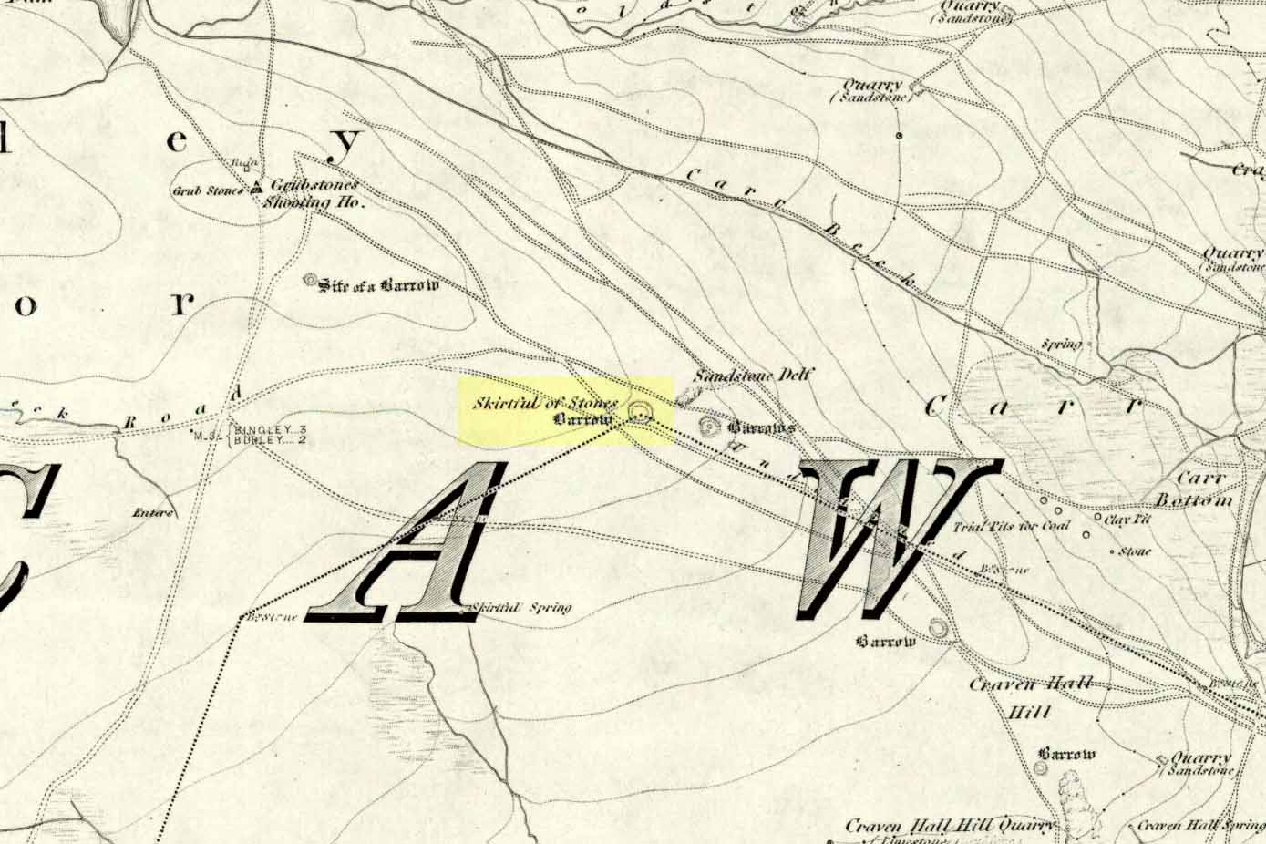
Great Skirtful of Stones cairn looking east to Otley Chevin
Due north of the Skirtful Spring water source, this is one of Ilkley Moor’s major prehistoric sites: ‘major’ for a number of reasons – not least of which is the size of the thing! Although getting somewhat overgrown these days as more of the heathlands encroach the mass of rocks that constitute the central ‘tomb’, it is still a formidable heap. Another reason this site is of importance is its position in the landscape: it can be seen as the peak or ‘nipple’ on the landscape from considerable distances north, south and east of here, rising up on the horizon and catching the eye from many miles away. This was obviously quite a deliberate function of the site when it was first constructed – thought to be in the Bronze or Iron Age period (sadly we have no decent excavation here to tell us just when it was made). Another reason for its importance is its position relative to a once huge prehistoric graveyard immediately east. And right next to it we also find a curious circular monument that has never been properly excavated, whose function is unknown. It is also the seeming focal point of at least one, though possibly three prehistoric trackways: one of which goes right past it, though swerves on its southern edge quite deliberately so as to not touch the monument. This trackway appears to have been a ceremonial ‘road of the dead,’ along which our ancestors were carried, resting for some reason at the nearby Roms Law, or Grubstones Circle, a few hundred yards to the west.
Wrongly ascribed as a “round barrow” by archaeologist Tim Darvill (1988), the Great Skirtful cairn was named in boundary changes made in 1733, where one Richard Barret of Hawksworth told that the site was “never heard go by any other name than Skirtfull of Stones.”
In 1901 there was an article in the local ‘Shipley Express‘ newspaper — and repeated in Mr Laurence’s (1991) fine History of Menston and Hawksworth — which gave the following details:
“Mr Turner led the way across Burley Moor to the Great Skirtful of Stones, a huge cairn of small boulders, nearly a hundred tons on a heap, although for centuries loads have been taken away to mend the trackways across the moor… The centre of the cairn is now hollow, as it was explored many years ago, and from the middle human bones were taken and submitted to Canon Greenwell and other archaeologists” – though I have found little in Greenwell’s works that adequately describe the finds here. Near the centre of the giant cairn is a large stone, of more recent centuries, which once stood upright and upon which is etched the words, “This is Rumbles Law.” The Shipley Express article goes on: “Mr Turner explained that ‘law’ was always used in the British sense for a hill, and Rumbles Hill, or cairn, was a conspicuous boundary mark for many centuries. He had found in the Burley Manor Rolls, two centuries back, that on Rogation Day, when the boundaries were beaten by the inhabitants, they met on this hill, and describing their boundaries, they concluded the nominy by joining in the words, “This is Rumbles Law.””
Great Skirtful on 1851 map
Several other giant cairns like this used to be visible on the moors, but over the years poor archaeological management has led to their gradual decline (and in editing this site profile in 2016, have to report that poor archaeological and moorland management is eating into and gradually diminishing this monument to this day). We still have the Great Skirtful’s little brother, the Little Skirtful of Stones, a half-mile north of here. The very depleted remains of the once-huge Nixon’s Station giant cairn can still be seen (just!) at the very top of Ilkley Moor 1½ miles (2.65km) west.* And we have the pairing of the giant round cairn and long cairn a few miles west on Bradley Moor, near Skipton. The tradition of such giant tombs on these hills was obviously an important one to our ancestors.
Folklore
We find a curious entry in the diaries of the Leeds historian Ralph Thoresby, in the year 1702, which seems to describe the Great Skirtful of Stones, adding a rather odd bit of folklore. (if it isn’t the Great Skirtful, we’re at a loss to account for the place described.) Mr Thoresby told how he and Sir Walter Hawksworth went for a walk on Hawksworth’s land and said how,
“he showed us a monumental heap of stones, in memory of three Scotch boys slain there by lightning, in his grandfather’s, Sir Richard Hawksworth’s time, as an old man attested to Sir Walter, who being then twelve years of age helped to lead the stones.”
As far as I’m aware, this old story of the three Scottish boys is described nowhere else.
Like many giant cairns, the Great Skirtful has a familiar creation myth to account for its appearance. In one version we hear that it was made when the local giant, Rombald (who lived on this moor) and his un-named wife were quarrelling and she dropped a few stones she was carrying in her apron. A variation swaps Rombald’s wife with the devil, who also, carelessly, let the mass of stones drop from his own apron to create the ancient cairn we still see today.
According to Jessica Lofthouse’s North Country Folklore (1976), a Norse giant by the name of Rawmr, “fell fighting against the Britons of Elmet and is buried, they say, on Hawksworth Moor” – i.e., the southeastern section of Rombald’s Moor, very probably at the Great Skirtful of Stones. I’ve yet to explore the history and etymology of the name Rawmr…
References:
Bennett, Paul, The Old Stones of Elmet, Capall Bann: Chieveley 2001.
Cowling, Eric T., Rombald’s Way, William Walker: Otley 1946.
Darvill, Timothy, Ancient Britain, AA: Basingstoke 1988.
Laurence, Alastair, A History of Menston and Hawksworth, Smith Settle: Otley 1991.
* Whoever is/was supposed to be responsible for the care of the Nixon’s Station giant cairn monument should be taken to task as it’s been virtually obliterated since when I first came here 30 years ago. Which useless local archaeologist and/or council official is responsible for its destruction? Who allowed it to happen? Why are Ilkley Moor’s prehistoric monument’s being so badly looked after by those who are paid to ensure their maintenance? Are their heads up their arses, in the sand, or—don’t tell me—the prawn sandwiches are to blame!?