Healing Well (destroyed): OS Grid Reference – NS 594 645
Archaeology & History
Mentioned briefly in James MacKinlay’s (1893) classic survey, this site was an ancient draw-well sunk near the old city centre but, like the ancient Moot Hill close by, has long since been destroyed. It is described amidst Andy MacGeorge’s (1880) historical survey of the ancient wells where he wrote:
“There was another…at the Barras Yet, near the port of that name at the foot of Saltmarket. It is mentioned in a minute of council in 1664, which ordains that ‘in respect of the heighting of the calsay at the Barrazet the well there be heightit twa stones higher round about, for preservation of childerin falling therein.’”
Although its exact whereabouts is not known, the proximity of the old fountain known as the Sir William Collins Memorial Fountain 100 yards east into the Glasgow Green Park at the bottom of the Saltmarket, might have robbed the Barrasyett Well of its water supply to gain existence.
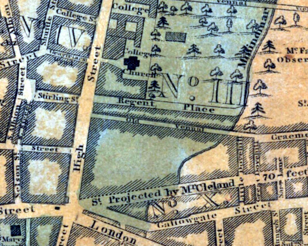
One of the many public wells in Glasgow, all trace of this site disappeared long ago. Found at the ancient heart of the city, the name ‘Vennel’ comes from the old dialect meaning, “a narrow alley or lane between houses,” which is where it was once found, along the Old Vennel. An early account of it was outlined in MacGeorge’s (1880) classic text, where it was described as,
“a draw well, as there is a minute of council in 1656 arranging with John Scott, mill-wright, to ‘rewle and governe’ this well and ‘the new well in Trongait’, he undertaking to uphold them ‘in cogis and rungis, the toun vphalding all ganging greth quhan athir it weirs or breckis.’”
A few years after this in 1663, it seems the Vennel Well had been closed due to it becoming regularly polluted and further council minutes told:
“Recommendis to the deane of gild to caus open again the wall at the Stincking Vennell, and to remove the old wark therof, and caus mak it lyk the wall in Trongait for service of the inhabitantis.”
Around this time a door and lock was put around the well to prevent people dumping and polluting the waters. Further council minutes from April 1663 inform us that,
“The keyes of the well at the Vennell is delyvered to Robert Bell, tailyeour, and he is to have twa dollouris yeirlie for his attending thereupon.”
All healing virtues, folklore and traditions of this site have long since been forgotten.
Holy Well (destroyed?): OS Grid Reference – NS 553 658
Archaeology & History
This is the conjectural title conferred by T.C.F. Brotchie (1920) upon a Well uncovered during construction of the Pearce Institute in Govan in 1908. It was certainly an old site and very well made by the sound of it: being “a stone-built well some ten feet deep (and) some eight feet below the present surface of the ground.” Brotchie thought it to be medieval in age – and he may have been right.
On asking local people if they knew anything about the site, he was lucky to meet “a very old man, a Mr Rellie”, who told him that when he was a boy his granny spoke of a lost “guid well (that) was near the kirk.” He continued:
“I have no doubt that the well discovered in 1908 was the guid well, and judging from its proximity to the god’s acre, and also from adjective ‘guid’, that the well was at one time the holy well of St. Constantine, who in the 6th century founded a church in Govan. Of course, that is conjecture, but I venture to think that the conjecture is reasonably well founded.”
The church is immediately adjacent and is indeed dedicated to St. Constantine. Inside of it are a variety of fascinating archaeological relics: not least of which is what Sam Small (2008) called the ‘Pagan Sun Stone’ upon which is carved an ancient swastika! That – I’ve got to see!
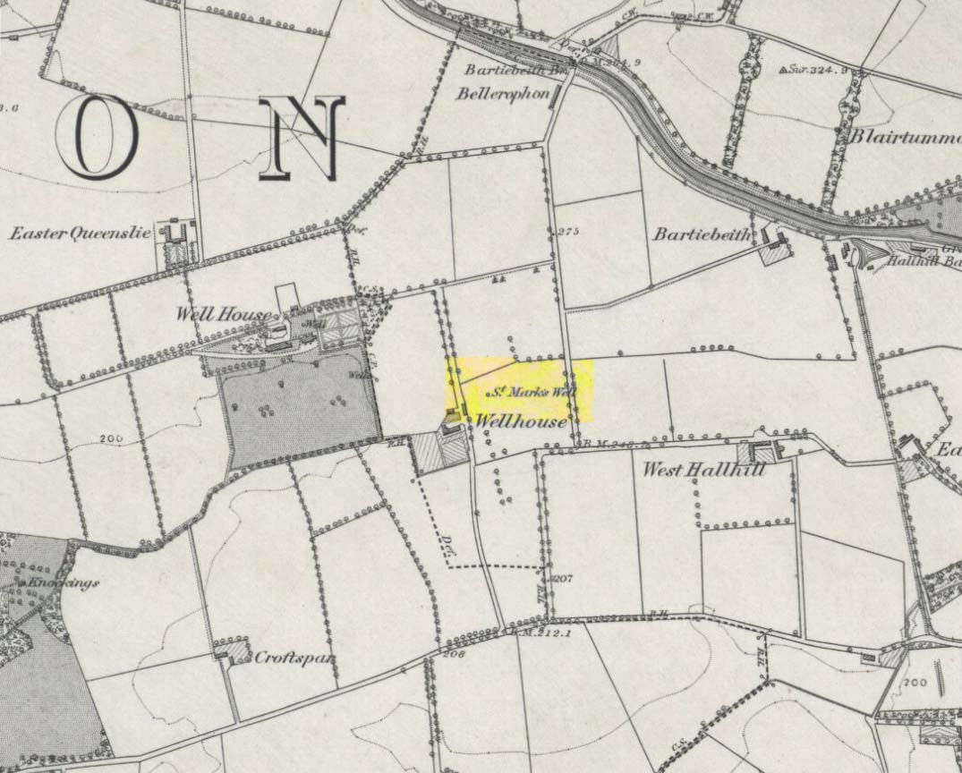
Holy Well (destroyed): OS Grid Reference – NS 667 653
Archaeology & History
St Marks Well on 1864 map
Information on this long forgotten holy well that once flowed a few miles east of Glasgow city centre, beneath what is now Wellhouse estate, is all but lost. Local history works of the area tell us little (though there must surely be something somewhere?) and even the place-name surveyor of this area—Peter Drummond (2014)—could find nothing. Noted by the Ordnance Survey lads in 1858, when they came to re-survey the area again in 1899 its waters had, it seems, been covered and carried into the ‘Well house’ less about 50 yards to the southwest (another ‘Wellhouse’ found 150 yards further west is the site that gives the estate its present name). From thereon, this wellhouse and St. Mark’s Well fell into the forgotten pages of history and, sadly it seems, even its oral tradition has died…
The origin and nature of the ‘well house’ isn’t too troublesome, as Drummond (2014) explains:
“The name Wellhouse exists in several places in Scotland, and could indicate a ‘house beside wells’, or a protective ‘house over wells’; the early record here suggests the former, since the first Glasgow Water Company’s Act was obtained in 1806, many years later.”
However, the reasons behind the dedication to St. Mark at this probably heathen arena in times gone by, seems to be quite a mystery. Perhaps the folklore of the saint concerned may be of some help.
Customs practiced on St. Mark’s Eve and St. Mark’s Day (April 24-5) are replete with animistic elements throughout and are certainly not christian! Six months after the old New Year, we find rituals once more allowing, not for the passing of, but the emergence of the dead: bringing the spirits into the Spring and Summer. Divination rites were practiced with Cannabis sativa no less! Prophecy and wise-women were advisors to the young. Walking backwards around wells were known at some St. Mark’s wells; whilst others without his name—but on this saint’s day—were leapt across, symbolizing the crossing of danger and darkness in the ritual calendar. All around this period of time, up to and including Beltane, the end of the dark cold year has passed, and these plentiful rites are prequels to the lighter days, warm spring, summer and good autumn: all vital rites for the people in their myths of the eternal return…
St. Mark’s Well at Glasgow meanwhile, seems to have lost its old tales… Surely not?
References:
Banks, M. MacLeod, British Calendar Customs: Scotland – volume 2, Folk-lore Society: Glasgow 1939.
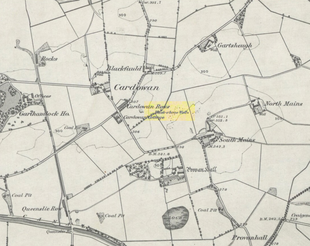
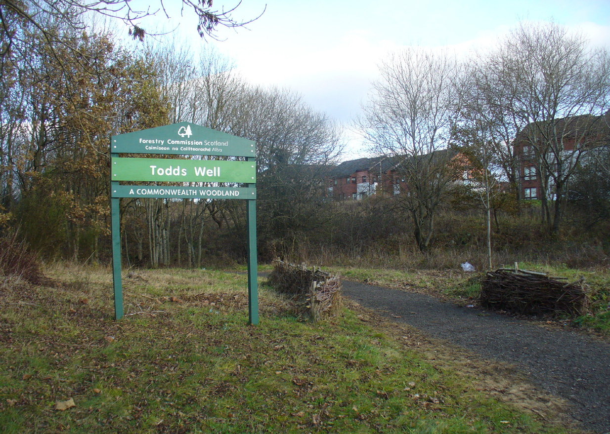
Many ways to get here, via the M8 or the B806. Just get to the Glasgow Fort shopping centre on the northern edge of Easterhouse, above Provan Hall. At the T-junction where the road from the Fort meets Auchinlea Road, note the sign saying ‘Todds Well’. Walk along the winding path, keeping to the lower side, and as you swing round the small hill, keep your eyes peeled for the small burn emerging from the shrubs 10-20 yards off the track. That’s the place.
Archaeology & History
Follow the track past the sign
Thankfully this site still exists and the waters—slow though they flow—are quite drinkable (us lot drank here anyway!). It was illustrated on the early OS-map of the area as the ‘Back o’ Brae Well’—no doubt gaining its name from the surveyors who took the directions to the place as its title! At the point where the spring water emerges from the Earth, very overgrown remains of low walling marks the opening well-head, and a number of larger stones mark the course of the tiny burn as you walk towards the track (though these could be more recent).
Getting ready for a drink!The slow-flowing water source
Thought to derive its name from the old word todd, meaning ‘fox’ (Grant 1973), a variant on the word may have meant that children’s games were played here (but without a confirmation of this in local folklore, we should urge caution). As well as being used by local people, the water from Todds Well was one of the places used by them there ‘rich’ folk who lived at nearby Provan House.
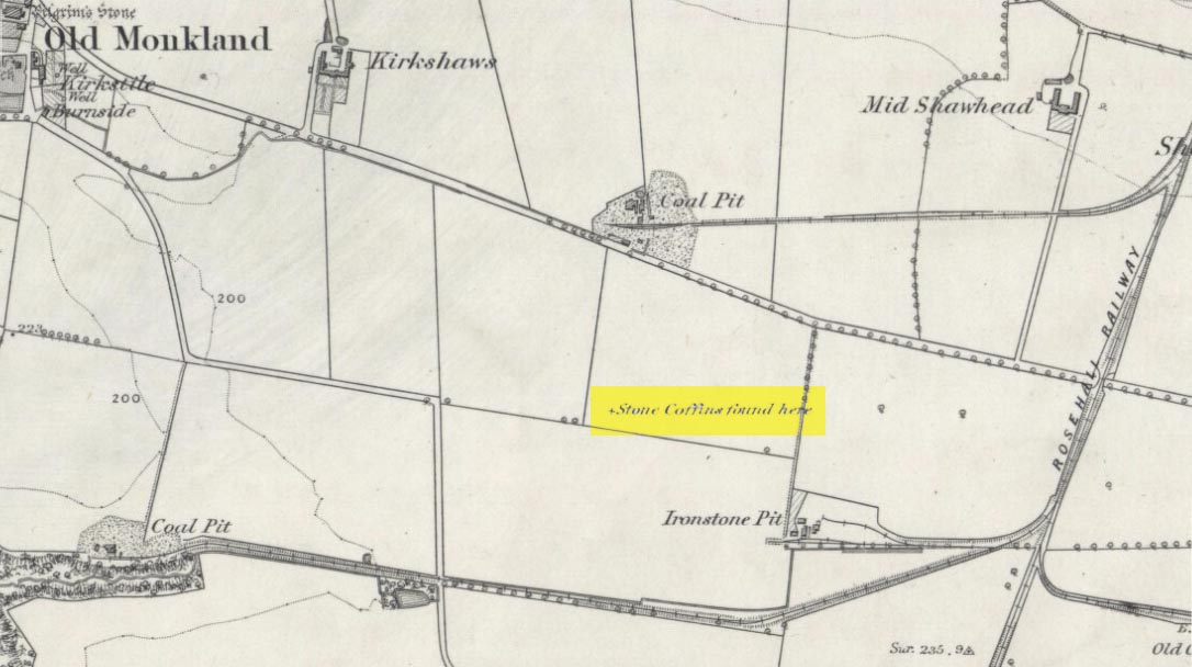
On the flat meadowlands below the slopes of Old Monkland, half-a-mile southeast of the legendary Pilgrim’s Stone, an old mound once lived. It may have been here for thousands of years but, with the encroachment of the toxic Industrialists, its time was coming to an end. The mound was levelled in 1832 and, beneath it, relics from a truly ancient past were unearthed – and destroyed of course. The account of its demise was told in the Glasgow Evening Post of May 26 that year. Many years later, the Royal Commission (1978) lads unearthed the information and included the site in their inventory for prehistoric sites in Lanarkshire. They told:
“In 1832 four cists were discovered during the levelling of a small mound 900m SE of Old Monkland Church. The cists, which measured about 1m by 0.6m, contained the remains of crouched inhumations, two of them double burials with the skulls at opposite ends of the cists. A stone hammer-head and a coin were found in one cist, the latter no doubt indicating subsequent disturbance. There is now no sign of the site, and it is not certain from the report whether the cists were inserted into a small natural mound or were covered by a barrow.
“The present farmer states that his father discovered a single cist during ploughing in the same field; it contained a pottery vessel which the landowner, Mr Sholto Douglas, was thought to have presented to a museum, but it cannot now be traced.”
References:
Royal Commission on the Ancient & Historical Monuments of Scotland, Lanarkshire: An Inventory of the Prehistoric and Roman Monuments, HMSO: Edinburgh 1978.
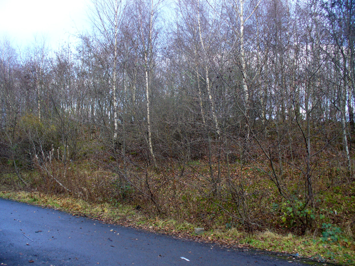
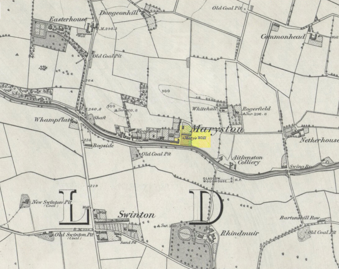
This old well, named after Queen Mary (one of at least three dedicated to her in Lanarkshire), was illustrated on the earliest Ordnance Survey map of the area in 1864. Local tradition tells us that the site gained its name when the great Mary Queen of Scots visited this old healing well, amidst a period when she stayed at Provan Hall 1½ mile away. Both she and her horse stopped and drank here for refreshment.
Site of Mary’s WellMary’s Well on 1864 OS-map
In the 19th and early 20th century, the well was converted into a pump and supplied the water to a row of cottages that used to be here. When we visited the site yesterday, no trace of the pump, nor any spring of water could be found. It seems that a huge pile of industrial crap has been piled on top of the well, then trees planted to give the impression that Nature has taken back the place. The well seems to have been completely destroyed (the photo here shows the spot where the well should be, just a few yards into the young trees). Due to this site being an important part of Scotland’s heritage, its ignorant destruction must be condemned.
Acknowledgements: Big thanks to the team – Nina Harris, Paul Hornby and Frank Mercer – for their work here. And to Dan Holdsworth and John Bestow for their additional input.
Of all the ancient wells in the city of Glasgow, this has to be one of the most intriguing! Descriptions of it are few and far between, but it is the name of the site which is of interest, to folklorists and occult historians alike. For the word ‘Bogle’ is another term for a ‘boggart’ or goblin of some sort! The well is mentioned in Andy MacGeorge’s (1880) excellent study in his description of ancient wells in the city. Citing notes from the 17th century, amidst many sites,
“Another was Bogle’s Well, in regard to which there is a minute of the town council “that Bogillis Well should be assayed for bringing and convoying the water of the same to the Hie street according to the right the town hes thereof,” and the magistrates are recommended to arrange for having this done “by conduits of led.””
…Obviously in the days when they were clueless about lead-poisoning! The word ‘bogillis’ is the early plural form of the bogle, or bogill (Grant 1941:201). But where exactly was this old well? Are there any other records hiding away to help us locate its original position? It seems to have been one in a cluster of legendary and holy wells in a very small area scattered between Glasgow’s cathedral, down the High Street and to the northern banks of the River Clyde… (the grid-reference given for this site is an approximation)
In a less esoteric fashion, the occult historian Jan Silver suggested that the name of the Well may relate to the family name, ‘Bogle’. This could indeed be the real story behind the well’s name.
Folklore
Traditionally ascribed in the lower counties of England to be an evil malicious sprite, in more northern counties and in Scotland the creature was said by Katherine Briggs (1979) to be a more “virtuous creature”, akin to the helpful brownies or urisks of country lore. This was said to be the case in William Henderson’s (1868) Folklore of the Northern Counties. Whether this well was haunted or the home of a bogle, we do not know as the folklore of this site appears to be lost; so I appeal to any students who might be able to enlighten us further on the place. The Forteans amongst you might have a cluster of ‘hauntings’ hereby, perhaps….
Healing Well (destroyed): OS Grid Reference – NS 5974 6534
Also Known as:
Meadow Well
Archaeology & History
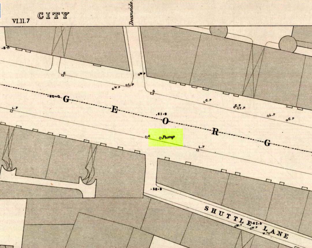
Deanside Well ‘pump’ in 1857
This little-known well—destroyed about two hundred years ago—was said to be one of the finest of all of the water supplies in the Glasgow district in pre-industrial days. The Glasgow historian Andy MacGeorge (1880) told it to be “a spring which was then, and for long afterwards, in great repute.” It was described as early as 1304 CE in a grant by Robert, bishop of Glasgow, allowing the christians to take water from the well and into their convent. The Latin transcript told:
“Noveritis Ros intuita caritatis, Dedisse fratribus Predicatoribus de Glasgu, Fontem quendam qui dicitur Meduwel in loco qui dicitur Denside scaturientem, in perpetuum conducendum in claustrum dictorum fratrum, ad usus necessarios eorundem” (Meaning, “Know ye that I Rosh, of charity, Among His brethren shared with the Preaching Friars of Glasgow, the gushing fountain called Meadow Well or Deanside as the place is called, to the cloisters is said to meet the needs” of the monks.”)
There is the possibility that the well was deemed as ‘holy’ due to it being of vital use to the bishop and monks, but I can find no record of it being ‘blessed’ as such; and the exact site of the bishop’s convent has been lost to history. In 1574 the “Deynside Well” needed cleaning due to people clogging up the waters with earth and stones; and sometime in the 18th century the spring of water was turned into a draw-well.
A northern antiquarian by the name of ‘ Senex’ (real name, Robert Reid) visited the Deanside Well at the end of the 18th century, telling of its whereabouts:
“In the year 1789 I had occasion daily to mount and descend the Deanside Brae, upon business, so that the state of the place at that date is quite familiar to me. The whole of the Deanside Brae was then vacant ground, as is shown in the old Maps of Glasgow. The Deanside or Meadow Well was situated in a meadow at the west end of Grayfriars’ (or Bun’s) Wynd, close to the footpath leading up to the Rottenrow; it is now on the street, at 88 George Street, opposite to the lane leading into Shuttle Street. The Deanside Well was then in a rural spot, the whole lands on the west, as far as Partick, being garden grounds and com fields.
“In Stuart’s Views the lonely foot passage up the Deanside Brae, to the Rottenrow, is very distinctly shown. The well stood at the south extremity of the said footpath, about the centre of the wynd.”
‘Senex’ also told that an ancient fair was held in “an enclosure” at the northwest corner of Shuttle Street, close to the Deanside Well.
Close to the ancient boundary of north Lanarkshire—if not actually on it—and looking down on the River Clyde, was once a prehistoric burial mound, probably Bronze Age in nature. Described first of all in David Ure’s (1793) early survey of Rutherglen, he told that:
“A tumulus of earth, supposed to have been originally a burying place, was lately demolished in the estate of Shawfield, a few yards from Polmadie; and the place where it stood converted into a mill-dam. None of its contents attracted the particular attention of the workmen employed in removing it.”
The site was subsequently referenced in Hugh MacDonald’s (1860) excellent work, but no remains of it now exist.