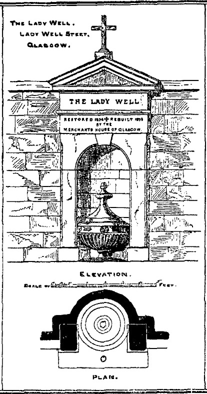
Get yourself to Glasgow Cathedral—wherein you’ll find St. Mungo’s Well—and walk down John Know Street. A coupla hundred yards down, across the road is a small street called Ladywell Lane (there’s no signpost for it though), running below the cemetery and leading to the back entrance of the giant Tennent’s Brewery. At the bottom of this, up against the wall on your left, is the Lady Well.
Archaeology & History
The origins and early traditional history of this once famous sacred well are sadly lost due to the intrusion of industrialism. It was obviously a place of some considerable repute and lent its name to local quarries and fields hereby. Used extensively by local people for countless centuries, things were to change in 1715 when the waters of this and other wells were to be kept clean by one John Black, “at a salary of 400 merks yearly.” The Glasgow historian Eyre-Todd (1934) told that,
“Black was to furnish them with chains, buckets, sheaves, ladles, and other necessary graith, aswell as with locks and iron bands. He was ‘to cleanse, muck and keep them clean,’ and to lock and open them in due time, evening and morning. In case of failure he was liable to a penalty of £100 Scots.”
Lady Well in 2015
Lady Well in 1883
That’s a helluva lot of money in those days! Even when M’Ure (1736) described it, only in passing, he had nothing to say about its curative properties or local rites. Once the Industrialists take control, the ways of local people are sanitized, sterilized and ‘progress’ outlaws tradition. The only reference to an earlier sacrality is in Mr Russel’s (1883) article, where he said simply, that the Lady Well was “so called after a fountain at the bottom of the Craigs…sacred in Popish times to the Virgin.”
The construction that we see today—of the well in its little enclave—was first built in 1835-6. The waters became polluted after they were redirected below the Necropolis and have not been used since (although they still flow out of the wall a couple of yards to the right, stinking!). The architectural feature was cleaned up and restored by the local brewery in 1983.
The site may have gained its name from one Lady Lochow, who lived nearby and built a hospital at the old Gorbels in the 14th century—but we might never know the real truth about the origin of its dedication. However, an intriguing ingredient relating to the dedication of the Lady Well is the incidence of a St. Anne’s Street that used to exist immediately to the east, as seen on the 1865 OS-map above. St. Anne may well be the mythic character behind the naming of this Lady Well, although I can find no literature to prove this. In the christian mythos, St. Anne was a very important character indeed: the mother of the Virgin Mary no less! However, as hagiographers from Attwater (1965), to Baring-Gould (1898) and Butler (1866) all tell, her biography is piecemeal—which is most surprising considering she was JC’s granny! Anne’s festival date was July 26 (a couple of days after Sirius enters the northern hemisphere); she was the patron saint of midwives, grandmothers and also miners, who invoked her as the deity who produced gold and silver—akin to the Earth Mother Herself! It’s obvious that Anne’s original mythic nature was subdued, as she represented an archaic root of matriarchal triplicity of the Virgin, the Lady and Old Woman and not the patriarchal triplicity of the incoming christian cult. The christian mythos at this Lady Well (as elsewhere) replaced one facet of the indigenous prima mater in Glasgow, known as the Cailleach—as shown in her attributes of midwife, grandmother and the deep Earth. If local historians can find field-names or wells dedicated to the Maiden, the Lady and the Carlin (or their variant titles) nearby, the lost layers of archaic Glasgow’s indigenous animistic folk memories could be mapped out once again…
References:
Attwater, Donald, The Penguin Dictionary of Saints, Penguin: Harmondsworth 1965.
Illustrated on the 1864 Ordnance Survey map, right by the roadside a hundred yards or so east of Braidwood House, once stood a proud standing stone – but sadly there are no remains of the monument today. It was said by Mr Groom (1882), in his encyclopaedic Gazetteer of Scotland, that the stone was “supposed to have been a milestone on Watling Street,” but we have no way of verifying this with any certainty. However, a similar association was conferred upon the stone by local people when the site was visited by the reverend John Wylie in 1839, when it was still standing. Writing in the Statistical Account of Carluke, Wylie told,
“It is supposed to have stood at the side of a Roman Road, passing from Lanark, across the bridge of the Mouse beneath Cartland Crags, through Lee Valley, across Fiddler’s Burn at Chapel, and thence by Braidwood into the main street.”
The last record we have of the stone still being in position is from the 1898 OS-map, but sometime thereafter it was uprooted and destroyed. Any further information about the stone would be gratefully welcomed.
References:
Groom, Francis H. (ed.), Ordnance Gazetteer of Scotland – volume 1, Thomas C. Jack: Edinburgh 1882.
Royal Commission on the Ancient & Historic Monuments of Scotland, Lanarkshire: An Inventory of the Prehistoric and Roman Monuments, HMSO: Edinburgh 1978.
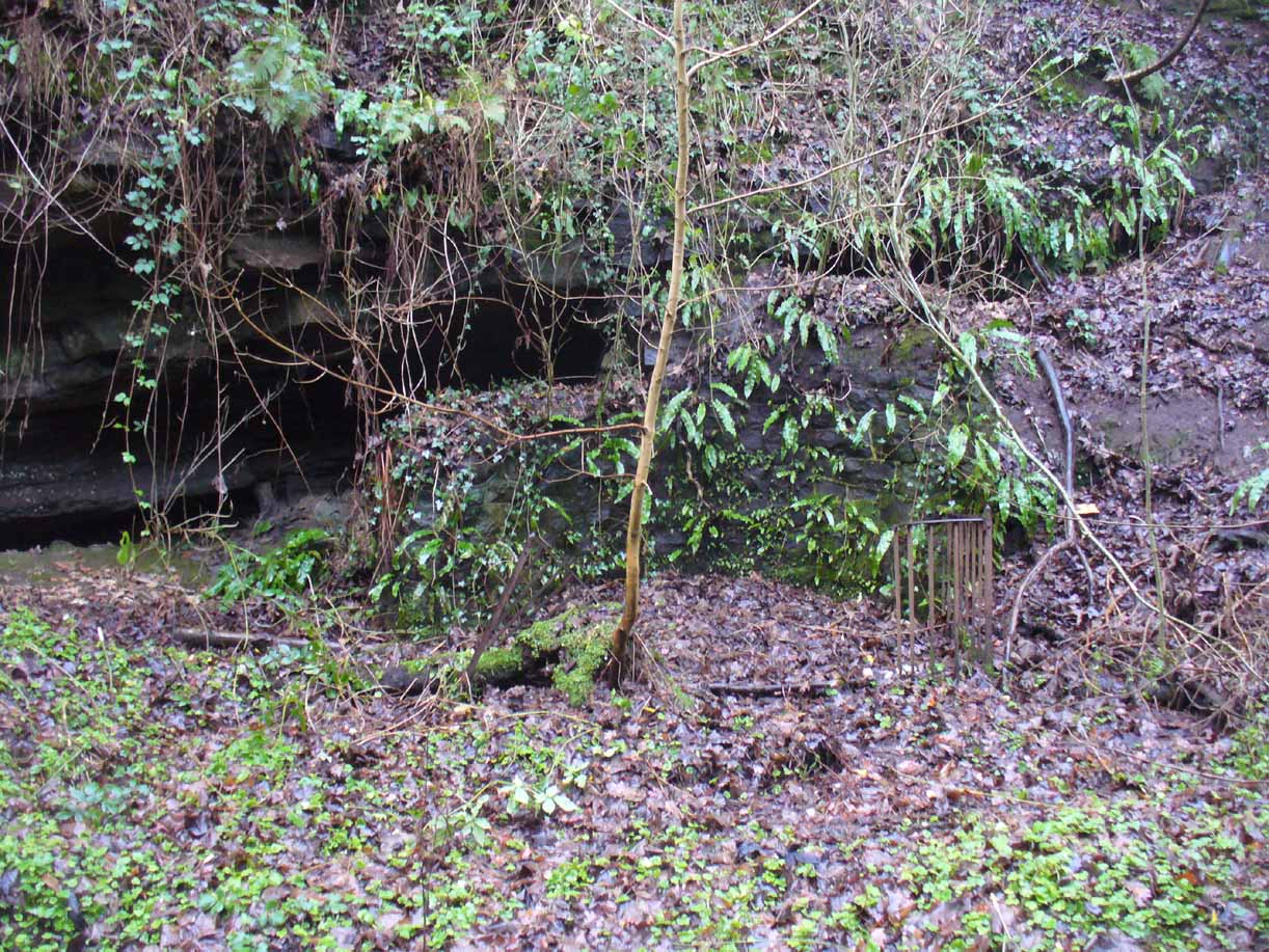
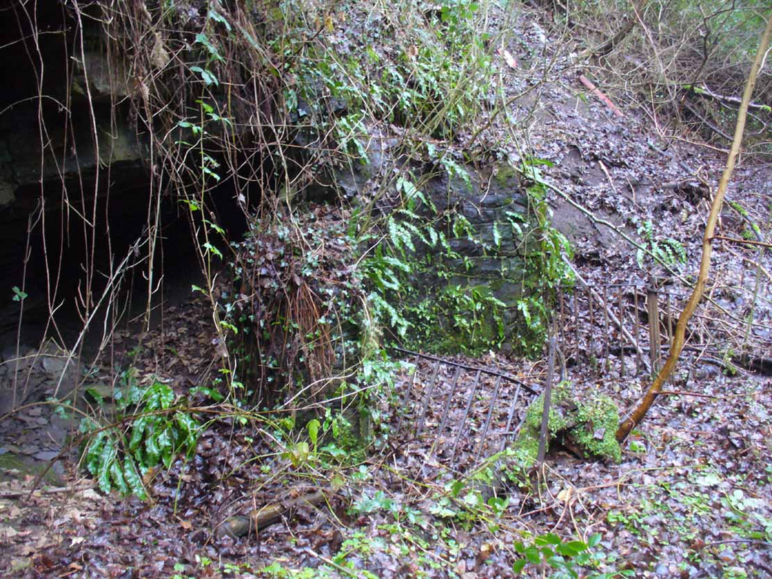
There must be an easier way to visit this site than the method I used. Which was: along Cambuslang’s Main Street (A724), turn up the B759 Greenlees Road for nearly 500 yards, turning left onto Vicarlands Road. Notice the grass verge and steep slope immediately to your left. Walk into the tree-lined gorge, following the left-side along the edges of the fencing. About 150 yards down the steep glen, note the very denuded arc of stone-walling and rickety fencing on the other side of the burn. That’s it! (broken glass and an excess of people’s domestic waste are all the way down; very difficult to reach, to say the least!)
Archaeology & History
Found in a dreadful state down the once-beautiful Borgie Glen, this is one of the most curious entries relating to sacred and healing springs of water anywhere in the British Isles. Indeed, the traditions and folklore told of it seem to make the site unique, thanks to one fascinating factor…..which we’ll get to, shortly…..
Remains of the Borgie Well
The name ‘Borgie’ is an oddity. Local historians J.T.T. Brown (1884) and James Wilson (1925) wondered whether it had Gaelic, Saxon or Norse origins, with Brown thinking it may have been either a multiple of a simple bore-well, or else a title given it by a travelling minister from Borgue, in Kirkcudbright. Mr Wilson took his etymology from the very far north where “there is a stream called the Borgie” (just below the Borgie souterrain). This is said to be Nordic in origin, with
“borg, a fort or shelter, and -ie, a terminal denoting a stream. It is almost certain that our Borgie has the same origin; that is, ‘the fort or shelter by the stream.’”
The Borgie Well was described by a number of authors, each of whom spoke of its renown in the 19th century and earlier. One of my favourite Glasgow writers, Hugh MacDonald (1860), had this to say about the place:
“There are several fine springs in the glen, at which groups of girls from the village, with their water pitchers, are generally congregated, lending an additional charm to the landscape, which is altogether of the most picturesque nature. One of these springs, called “the Borgie well,” is famous for the quality of its water, which, it is jocularly said, has a deteriorating influence on the wits of those who habitually use it. Those who drink of the “Borgie,” we were informed by a gash old fellow who once helped us to a draught of it, are sure to turn “half daft,” and will never leave Cambuslang if they can help it. However this may be, we can assure such of our readers as may venture to taste it that they will find a bicker of it a treat of no ordinary kind, more especially if they have threaded the mazes of the glen, as we have been doing, under the vertical radiance of a July sun.”
Borgie Well, looking south
It’s somewhat troublesome to reach, but a beautiful landscape indeed is where, today, only remnants of the Borgie Well exist. A very eroded semi-circle of walling and iron bars protects what was once the waters of the well—which have long since fallen back to Earth. Behind it, right behind it, overhangs the cliff and a small cave: a recess into the Earth with its very own feeling. It has the look and feel of a witch’s or hermit’s den with distinct oracular properties. This geomancy would not have gone unnoticed by our ancestors. In this enclaved silence, the once bubbling waters beneath the cliffs give a feel of ancient genius loci—a memory still there, despite modernity. Whether this crack in the Earth and its pure spring waters was some sort of Delphic Oracle in days gone by, only transpersonal ventures may retrieve… Perhaps…
In the 19th century a path took you into the glen from the north, and a commemorative plaque was erected here by a Dr Muirhead, where now lie ruins. It read:
The Borgie Well here
Ran many a year.
Then comes the main verse :_
Wells wane away,
Brief, too, man’s stay,
Our race alone abides.
A s burns purl on
With mirth or moan,
Old Ocean with its tides,
Each longest day
Join hands and say
(Here where once flowed the well)
We hold the grip
Friends don’t let slip
The Bonny Borgie Dell.
1879.
At the base was carved an appeal to the local folk:
Boys, guard this well, and guard this stone,
Because, because, both are your own.
The plaque has long since gone; and according to the local historian J.T.T. Brown (1884), the waters went with it due to local mining operations around the same time. But there was an additional rhyme sang of the Borgie Well which thankfully keeps the feel of its memory truly awake (to folk like me anyway!). It is somewhat of a puzzle to interpret. Spoken of from several centuries ago, it thankfully still prevails:
A drink 0′ the Borgie, a taste 0′ the weed,
Sets a’ the Cam’slang folks wrang in the heid.
Meaning simply, if you drink the waters of this well, you’ll get inebriated! It’s the derivation of the word ‘weed’ that is intriguing here. In Grant’s (1975) massive Scottish dialect work we are given several meanings. The most obvious is that the weed in the poem is, literally, a weed as we all know it. But it also means ‘a fever’; also ‘to cut away’ or ‘thin out’; to carry off or remove (especially by death); as well as a shroud or sheet of cloth. These meanings are found echoed, with slight variants, in the english dialect equivalent of Joseph Wright. (1905) Hugh MacDonald told that the Enchanter’s Nightshade (Circaea lutetiana) grew hereby—which, initially, one might think could account for this curious rhyme. But the Enchanter’s Nightshade has nothing to do with the psychoactive Nightshade family, well-known in the shamanistic practices of our forefathers. However, in the old pages of one Folklore Society text, William Black (1883), in repeating the curious rhyme, told us:
“The Borgie well, at Cambuslang, near Glasgow, is credited with making mad those who drink from it; according to the local rhyme —
A drink of the Borgie, a bite of the weed,
Sets a’ the Cam’slang folk wrang in the head.”
The weed is the weedy fungi.”
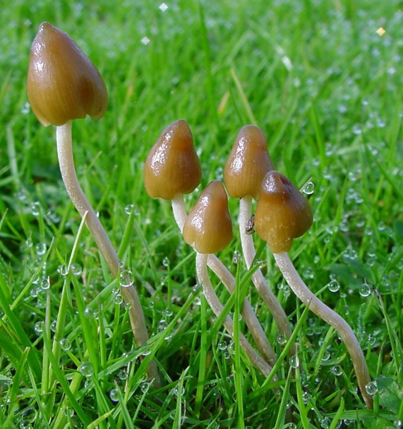
A mushroom no less! In John Bourke’s curious (1891) analysis of early mushroom use, he repeats Mr Black’s derivation. If this ‘weed’ was indeed use of mushrooms that made the local folk “go mad” or “wrang in the head” (and if not – what was it?), it’s an early literary account of magic mushroom intoxication! If this interpretation is correct, the likelihood is that the Borgie Well was a site used for ritual or social use of such intoxicants. Many sites across the world were used by indigenous people for ritual intoxication, and this could be one of the last folk remnants of such usage here. We know that Scotland has its own version of cocaine, used extensively by our ancestors (even the Romans described it) and which was still being used by working Highlanders in the 20th century—but early descriptions of mind-affecting mushrooms are rare indeed!
Psilocybe semilanceataAmanita muscaria
Mr Black gives no further folklore, nor the source of his information, other than to suggest that the madness incurred by the Well typified the people of Cambuslang! “Weedy fungi” may have been ergot (Claviceps purpurea), but the incidence of the grasses upon which it primarily grows, rye, here seems unlikely—and the folklore would certainly have included the ‘death’ aspects which that fungus brings! Fly agarics (Amanita muscaria) however, may have grown here. Old birches are close by, which produce nice quantities of those beautiful fellas. On the fields above the gorge, where now houses grow, Liberty Caps (Psilocybe semilanceata) may have profused—as they do in the field edges further out of town—but this species has no local cultural history known about from the early period. We must, however, maintain a healthy scepticism about this interpretation—but at the same time we have to take into account the ‘intoxicating’ madness which the combination of the “waters and the weed” elicited.
One final note I have to make before closing this site entry: despite the beautiful location, this small gorge is in a fucking disgraceful state. Some of the people who live in the houses above the gorge should be fucking ashamed of themselves, dumping masses of their household rubbish and tons of broken glass into the glen. If these people are Scottish, WTF are you doing polluting your own landscape like this? This almost forgotten sacred site needs renewing and maintaining as an important part of your ancient heritage. Have you no respect for your own land?!?
References:
Armitage, Paul, The Ancient and Holy Wells of Glasgow, TNA 2017.
Black, William George, Folk Medicine: A Chapter in the History of Culture, Folk-lore Society: London 1883.
Walker, J.R., ‘”Holy Wells” in Scotland”, in Proceedings of the Society of Antiquaries, Scotland, volume 17, 1883.
Wilson, James A., AHistory of Cambuslang, Jackson Wylie 1925.
Wright, Joseph, The English Dialect Dictionary – volume 6, Henry Frowde: Oxford 1905.
Acknowledgements: Huge thanks again, in various ways, to Nina Harris for getting us here; and Paul Hornby, for reminding me of my literary sources when I needed them! Thanks too to Travis Brodick and his beautiful photo of the Amanita muscaria cluster.
Healing Well (destroyed): OS Grid Reference – NS 5619 6654
Archaeology & History
Along the B808, between Beith Street and Byres Road, where it meets the main Dumbarton Road, the memory of Cooper’s Well is preserved in the street-name. It was one of more than a dozen springs in the area, but was one of the most renowned by local people.
Although not shown on the early OS-maps, thankfully the local historian and folklorist—and early environmentalist, it must be said!—James Napier (1873), gave a good account of it in his excellent work on the traditions of the area:
“Cooper’s Well was situated on the side of the road at the north-west end of Well Street, at the corner of where the Gas-work wall now is. It was about three feet deep, and had two steps leading down to the water from the road. Two sides and back were walled up higher than the road, and covered with a stone slab. It was celebrated in the neighbourhood as a drinking water, being strongly chalybeate, and therefore could not be used for cooking purposes. Although shallow, it was never frozen during winter (so that it must have come from a considerable depth), and it was cold in summer. On a warm summer Sunday evening we have seen people, not only from all parts of the village, but from the gentle houses in the neighbourhood, carrying water from the Cooper’s Well to drink. It is from this well the street has its name. The Gas-work dried up the well. There was a story current of some Glasgow people who were visiting at Mr. Sharp’s of Horslethill. Mrs. Sharp had been baking some oatcakes with butter or dripping in them, which caused them to be very fine and short. The Glasgow gentlemen were anxious to know how they were baked, and were told that they were baked with the Cooper’s Well water, some of which they had got a drink of. Shortly after some of the gentlemen sent out their servants to Partick for a supply of the water, but the servants could not succeed in making the cakes so nice as those got from Mrs Sharp. For long after this, butter-cakes were known in and around Partick as Cooper’s Well bread.”
I have to admit I’ve not visited this site, but presume that all trace of the site has disappeared.
Holy Well (destroyed): OS Grid Reference – NS 6451 5981
Archaeology & History
Site shown on 1864 map
Illustrated on the earliest OS-map of the region, this is one of four holy and healing wells within half-a-mile of each other—including the legendary Borgie Well in the Borgie Glen. The waters from here emerged above the rise, close to the end of Mansefield Avenue, from where you look down onto the wooded burn. When it was visited by the Ordnance Survey chaps in the 19th century, they told simply that water here “is taken from pipes being laid from it to the Manse to supply the Minister.”
Acknowledgements:Huge thanks for use of the Ordnance Survey map in this site profile, reproduced with the kind permission of the National Library of Scotland.
St. Oswald’s Well was described in Hew Scott’s (1920) magnum opus as being beside the parish church of the same name, but other references to it are scant. An old well-house was built besides or over the waters, which subsequently became known as the Kirk Well due to its proximity to the church, 125 yards to the northwest. All trace of it appears to have gone. The road to the west of the site also 125 yards away, called Kirkwell Road, seems to be the last piece of folk memory that remains.
St. Oswald himself was a British tribal leader of Northumbrian descent who, legend tells, went to Iona and became a christian. He had to leave the island eventually and go back into Yorkshire to bring peace back into the northern counties. Whether this Well of his was dedicated to him as a result of his journey from back south from Iona, we do not know. His saint’s day is August 5—very close indeed to that old heathen celebration time of Lughnasadh or Lammas. Most likely this is not just a coincidence, but will have related to what local folk were doing before the christian impositions.
The name of this site alone insisted that I bring it to people’s attention! If it was a healing well relating to its name, I wonder what it was used for! It’s described just once in the New Statistical Account (1845) for Lanarkshire, where Pete Brown said briefly:
“On the south side of the road from Auchinloch to Glasgow, there is still the Cockplay Well, over which many proprietors and feuars have a servitude.”
Two roads came out of the village at the time of the NSA notes: one to the immediate west and the other to the south. None of the maps cite the place-name ‘Cockplay’, but two ‘wells’ occur on the outgoing western road. One is in the village itself, behind some cottages; this is not likely to be the site in question, as the description would surely have stated that the well was in the village. However, “on the south side of the road” one mile west of the village, roughly halfway between Wallace’s Well and Cardyke there is a ‘Well’ shown on the early OS-maps. This has to be the most likely contender.
The etymology may revolve around variants on the word old english word cocc, which in this instance is likely to be ‘bird/s’ or a cock, as a in the male domestic fowl; effectively making it the ‘well where the birds played.’ More help and information on it would be good.
Get onto the A763 road several miles east of Glasgow city centre and go along Gardenside Avenue onto the Carmyle estate. A few hundred yards on, turn right down Carmyle Avenue, then left onto River Road. Follow the footpath along the edge of the River Clyde for nearly a mile—past the recently destroyed John’s Well—until you hit the remnants of Kenmuir Woods. You’ll reach some large polluted pools and when you reach the gap between the first and second pool, walk into the trees above the river and the Well is there.
Archaeology & History
The decaying remains of this old well can still be seen, incredibly, in the small copse of trees that are Kenmuir Woods, just a few yards above the River Clyde, 160 yards below the M8 and the same distance west of the Daldowie sewage treatment works, with polluted water treatment pools just yards away! Not the sort of place you’d take a partner for any sort of marriage ceremony whatsoever nowadays! But it wasn’t always like this of course. Only since the Industrialists stamped their mark…
When Hugh MacDonald (1860) wrote the finest narrative of this arena in the middle of the 19th century, his evocative words painted the entire landscape with a veil untouched since his days. Indeed, it is truly like another world compared to the sacrilege of what we see today:
“It is a wild and bosky scene, covered with a picturesque profusion of timber, and is the habitat of flowers innumerable. The weaver herbalists of Camlachie and Parkhead find it a perfect storehouse of medicinal rarities; and on Sundays they may be seen in sickly groups prying into every green recess in search of plants which old Culpepper would have loved for their rare qualities, or carrying them home in odorous bundles, confident of having obtained a mastery over “all the ills that flesh is heir to.” The botanist may also occasionally be seen lurking here, vasculum in hand, or on bended knee, examining the structure of some strange flower. But even the mere general lover of flowers will here find much to reward his attention. At present the May-flower (Caltha palustris), the wild hyacinth, the craw-flower of Tannahill, the red campion (Lychnis dioica), the odorous woodruff (Asperula oderata), the globe-flower or lucken gowan (Trollius europœus), and many others are in full bloom, and so thickly strewn that even as the poet says, “You cannot see the grass for flowers.”
“At the foot of the bank, near its upper extremity, there is a fine spring, which is known by the name of the ‘Marriage Well,’ from a couple of curiously united trees which rise at its side and fling their shadows over its breast. To this spot, in other days, came wedding parties, on the day after marriage, to drink of the crystal water, and, in a cup of the mountain-dew, to pledge long life and happiness to the loving pair whom, on the previous day, old Hymen had made one in the bands which death alone can sever. After imbibing a draught of the sacred fluid from the cup of Diogenes, we rest a brief space on the margin of the well.”
One wonders how far back in time the attribution of ‘Marriage Well’ from the animism of the trees went; and whether marriage ceremonies were performed here, quietly, away from the prying eyes of the Church and invading english in centuries much earlier under the guidance of the Moon. It’s probable…
Nature’s cloak was still intact here when, many years after Hugh MacDonald’s visit, the local writer Dan McAleer (1930) informed us that,
“Shy bridesmaids and their groomsmen used to visit after a wedding to drink the mystic waters of the Marriage Well. Certain places about the woods were well adapted for picnics, etc. After tea and refreshments the lads and lassies passed hours in amusement trying to step over the well and anyone soiling the water in any way while stepping across it would not get married that year.”
Much of the beauty of the landscape and Her waters, and the rich romance that arises from Her cyclical forms are long gone from here now… Cold ‘progress’ bereft of the necessity of Nature’s sanctity is no progress at all… Although the genius loci of the place may have long since gone, at the very least the regional council—or decent locals, if the council can’t be arsed—could erect some memorial and save the failing Marriage Well from what seems to be its close and final demise….
References:
Carpenter, Edward, Civilization: Its Cause and Cure, George Allen & Unwin: New York 1914.
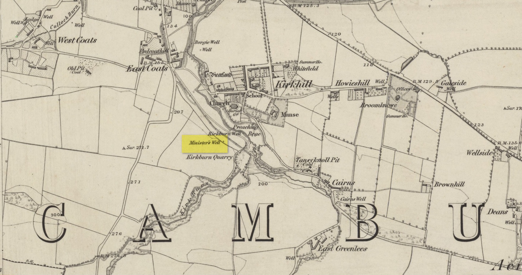
Holy Well (destroyed): OS Grid Reference – NS 6029 6547
Also Known as:
Minister’s Well
Archaeology & History
Site of the Priests Well in 1865
A ‘holy well’ with a bit of a difference when it was designated as such, however many centuries ago. Found on the southern slopes below Glasgow ‘s Cathedral, just a few yards west above the Molendinar Burn (upon which Wishart Street now sits), this was deemed to be a well only to be used by the christian ministers or priests from above. Local people were not supposed to drink here it seems! Instead, they were supposed to either drink from the burn, or walk a short distance down to the Lady Well (now badly polluted) 175 yards to the southeast. I don’t expect many Glasgow folk paid that much attention to such arrogant ministerial laws!
Shown on the earliest OS-map, simply as a ‘Well’, this is one of at least four water sources within a square mile of the Cathedral (including St. Mungo’s and Lady Well) that were deemed as ‘sacred’. It truly makes you wonder what on Earth was here before the christians came along and built their huge temple on the rocks above…. What animistic heathen rites and traditions were suppressed around this natural landscape before the toxic blanket of christianity was imposed upon us?
Healing Well (destroyed): Os Grid Reference – NS 5931 6500
Also Known as:
West Port Well
Archaeology & History
Once found near the old crossroads of Trongate, Arygle Street and Stockwell Street, the Trongate Well is another of old Glasgow’s lost sites, piped-off and added to the city’s water system sometime in the 19th century. A pity, as the fresh water from here was highly regarded (moreso than the modern stuff with its chlorine and other unnecessary additives). The well could be found where the Highland Gaelic Society built their own public house and, as a result, was very popular with local folk. It was,
“Opposite the old Black Bull in Trongate…afterwards covered in, which was famous in the palmy days of cold punch, and which is alluded to in Cyril Thornton as ‘the West Port Well.’” (MacGeorge 1880)
Old cattle markets were held here and MacGeorge (1880) wrote how it was a very popular and favourite place in its day, “surrounded by large numbers of the town’s people waiting a supply.”
The old Black Bull pub was much used by drovers and across from it was the old draw well, whose waters were of such renown that they were described in the verse, The Lament of Capt Paton, thus:
“Or if a bowl was mentioned,
The Captain he would ring,
And bid Nelly to the West Port,
And a stoup of water bring;
Then he would mix the genuine stuff,
As they made it long ago,
With limes that on his property
In Trinidad did grow.
O! we ne’er shall taste the like
Of Captain Pateon’s punch no mo’!”