Ostensibly non-linear carved designs, generally assumed to be Bronze Age in date, but many originate in the neolithic period (some may indeed date back to 5000 BCE). Their central features are small rounded cup-markings, circles, semi-circles, curved lines (short, mid-length, and long), straight-ish lines, double- and multiple-rings, all in usually abstract design-forms. Their almost complete non-linear nature relate to non-egoic structuralisms, making them difficult to ‘intellectually’ grasp. Added to this is that no two carvings are the same. Although no direct ‘meaning’ can be ascribed to the carvings, many of them have a relationship with ancient notions of death and/or burial. In animistic terms, they relate to the spirit of rocks and other features of the natural landscape. They have very little relationship with alignment features (though exceptions in some megalithic rings have been found). Some modern writers allege positive relationships with water, but this ingredient (if tenable) cannot yet be said with any certainty: the idea should be forged onto animistic relationships with the land itself.
From Dollar, take the steep road up to Castle Campbell (ask a local if you get lost). When you’ve got into the building and paid your fiver, walk straight forward as if you’re heading to the front gardens, but stay within the castle by walking left on the inner-front section of the building, all the way along to the dark room in the far corner at the end of the path. Just before you walk into the end room, look at the ground rock beneath your feet.
Archaeology & History
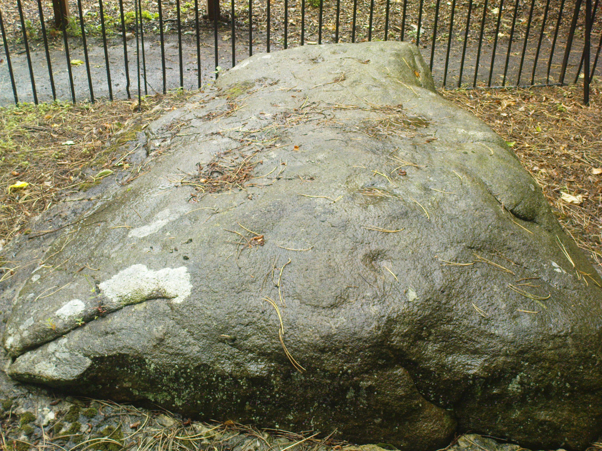
My first and only visit to the superb half-restored ruins of Castle Campbell was in the company of the author Marion Woolley. It was a damn good day and the castle here is really worth checking out! But as Marion and I wandered the grounds and internal remains, my eyes caught sight of what looked like a cluster of cup-markings, never previously recorded, on a section of earthfast rock over which a section of the Castle had been built.
A distinct arc of at least four cup-marks was accompanied with outlying single cups on either side of it. Beneath the gravel it seemed that more were waiting to be be unearthed—but we left them alone. As you can see in the photo here, the cup-marks seem typical of those we find in their thousands across northern Britain. However, the rock hereby is volcanic and conglomerate and may be the result of such natural processes. I’m truly not sure. A local archaeologist in Stirling thought the carving looked authentic – but we need to return here and brush off the rest of the gravel to see in greater detail the extent of the cups. There seemed to be more of them hiding at the edges.
If anyone finds out more about this, or gets some better photos, or ascertains this as a simple geophysical artifact, please lemme know.
From Killin heading out along the northern Loch Tay road, turn left just past the Bridge of Lochay hotel and go right to the very end of Glen Lochay, just past Kenknock. From here you’ve gotta keep walking along the glen’s dirt-track, and when you go through the third gate along (about a mile), another 100 yards on, keep your eyes peeled for a reasonably large boulder on the left of the track. This is your marker to go up on the right-hand side of the track, where the large stone is about 20 yards up the slope.
Archaeology & History
Three cup-marks & their lichen
Not far from a prehistoric hut circle relocated by archaeologist Dugald MacInnes I found this, a previously unrecorded cup-marked stone, when I was ambling about around the top of this beautiful valley last week. It’s only a simple cup-marked stone with two very distinct cups and a probable third in the middle of the well-defined ones. A covering of aged lichen was living on the carved rock and it seemed that there may have been other cups beneath the lichen — but I’ve got a real love of these old plants and wasn’t about to tear them from their homely stone.
There are some other little-known unrecorded human remains all along the slopes above here, which I’ll have a look at when next up this Valley of the Black Goddess…
Take the same directions as if you’re going to Dave’s Stone, to the eastern end of Rivock Edge itself. Then take less than 10 steps further onto the moor itself and you’ll see the stone pretty low down in the heather. (please note that grid-reference above needs revising)
Archaeology & History
…and looking straight down!
Found about 10 yards onto the flat ridge south of Dave’s Stone cup-marked stone, the vegetation covering this carving had only recently been brushed off when we revisited the place in 2012, by members of the Ilkley CSI team in their own survey of the area. As you can see, it’s a simple design of just two well-preserved cups on a small rounded stone. What may be the remains of a very faint ring arc is possible over one of the two cups. Nowt much more to say really!
From Cow & Calf Hotel head onto the moor above you, following the same directions to reach the ornately carved Idol Stone (and its immediate companions). Ahead of you on the same footpath, about 100 yards along, as it begins to slope up the hill further onto the moor, you’ll see a large upright pyramid-shaped stone, about 8 feet all, right at the side of the path. Y’ can’t miss it!
Archaeology & History
Deep cups & lines on top
Although ascribed as a cup-marked stone in usual surveys, the cup-markings on top of this rock are seemingly Nature’s handiwork. There is a possibility that cup-markings were carved into the top of the stone, many thousands of years ago, but due to the centuries of wind and weathering, we cannot in anyway assess the curvaceous bowls and lines running across and from the top of this rock to be artificial.
Folklore
The name ‘Idol Stone’ seems to have come about as a result of the judaeo-christian Victorian obsession of satanic idolatry in all things natural – which many of them still fear. Sadly there are no early accounts of practices of idolatry at this rock, until it was used by chaos magickians in the formative years of that Current in the 1980s.
References:
Bennett, Paul, The Old Stones of Elmet, Capall Bann: Milverton 2001.
Boughey, K.J.S. & Vickerman, E.A., Prehistoric Rock Art of the West Riding, WYAS: Leeds 2003.
Forrest, C. & Grainge, William, A Ramble on Rumbald’s Moor, among the Dwellings, Cairns and Circles of the Ancient Britons, W.T. Lamb: Wakefield 1868-9.
Hedges, John (ed), The Carved Rocks on Rombald’s Moor, WYMCC: Wakefield 1986.
Holmes, J., “A Sketch of the Prehistoric Remains of Rombald’s Moor,” in Proceedings of the Yorkshire Geological Society, volume 9, 1887.
Speight, Harry, Upper Wharfedale, Elliott Stock: London 1900.
Follow the same directions to find the Balfarg Stone Circle. From the A92 going north from Glenrothes, turn E onto the country lane to Star and Kennoway. 100 yards on there’s a sign for Balbirnie; turn right here and about 200 yards on, where the road bends right, the circle’s just below you). This carving is perched on its side in one of the preserved grave cists within the circle, easily visible at ground level.
Archaeology & History
This carving (and its adjacent compatriot) was found insidethe Balbirnie stone circle when it stood in its original position more than 100 yards northwest of the place it presently occupies (at NO 2850 0304). Thankfully, when the megalithic ring was moved and reconstructed, its original status was kept, including the repositioning of this impressive small cup-and-ring stone – despite it being a copy of the original.
Early photo of the carving
Like a good number of prehistoric tombs, this small carved stone was stood on edge, facing into the stone-lined tomb (cist), obviously representative of some important element in the Land of the Ancestors: perhaps a map of the landscape therein; perhaps a personal token; perhaps indicative of the spirits of the dead; perhaps a magickal amulet for safe guidance. There are a number of ritual possibilities here, and whichever it was, we can be sure the symbols were representative of the animistic cosmology of the neolithic people living hereby, linking the living with the dead.
As you can see from the original photograph, a number of cup-marks along the edges of the stone are accompanied by two or three cup-and-rings, one of which is very faint. Some carved lines run between some facets of the carving, linking one mythic element to another. Ron Morris (1981) described the carving, simplistically, as,
“Under a cairn, within a ring of stones, one of 5 cists had, carved on the inside of a side-slab (sandstone), ¾m by ½m by ¼m (2¾ft x 1¾ft x ¾ft): 2 cups-and-one-ring—one faint and incomplete—and also 8 cups, 2 with ‘tails’. Greatest diameter of ring 12cm (5in), and carving depths up to 2cm (1in).”
References:
Burl, Aubrey, Rings of Stone, BCA: London 1979.
Morris, Ronald W.B., The Prehistoric Rock Art of Southern Scotland, BAR: Oxford 1981.
This carved stone is now held in one of the museums. To get a better idea of its original locale, take the directions to reach the Balfarg Stone Circle (from the A92 going north from Glenrothes, turn E onto the country lane to Star and Kennoway. 100 yards on there’s a sign for Balbirnie; turn right here and about 200 yards on, where the road bends right, the circle’s just below you) and look at the small stone-lined tombs (cists), within which this carving was first found.
Archaeology & History
This carving (and its adjacent compatriot) was first found within the Balfarg stone circle that originally stood more than 100 yards northwest of the site it now occupies (at NO 2850 0304). Found inside the edge of another prehistoric stone-lined tomb (cist) within the stone circle, the small elongated stone possessed at least 16 singular cup-marks along one flat face of the rock. Two adjacent cup-marks may be linked by a small line running between them. As you can see in the old photograph here, most of the cups run in two parallel lines, similar to the primary feature found on the more famous Idol Stone on Ilkley Moor.
Described in association with the Balbirnie 1 carving by Ronald Morris (1981) as simply, “a slab in another cist (with) cup-marks,” like its partner just a few yards away this carving was again representative of some important mythic element in the Land of the Dead to the person whose body was laid here.
References:
Morris, Ronald W.B., The Prehistoric Rock Art of Southern Scotland, BAR: Oxford 1981.
Cup-marked stone, with Dunruchan C standing stone on horizon
We parked-up by the small trackway into the fields on the opposite side of the road 100 yards short of Craigneich across from the standing stone, then walked up the track, thru the gate, then walked uphill. Tis boggy & bumpy as you’d expect – and then, as you espy the giant standing stones of Dunruchan on the ridges above, watch out for the large rounded boulder (amongst many) as you near the level 100 yards or so before the magnificent Dunruchan A stone. Look around!
Archaeology & History
Close-up of cup-marks
Not far from the cup-marked stones of Blar an Rodhar is what appears to be another such carving. Here, two archetypal cup-marks are clearly visible on one of the large rocks on the slope up to the huge standing stone of Dunruchan A. There may be other faint cup-marks on this boulder, but the light wasn’t too good when we first found this, so I’m not sure about any others. The main two however, as the photo shows, stand out! A grassy overgrown cairn is some 10 yards away to the east, almost in line with the largest Dunruchan Stone. The Dunruchan C standing stone is also clearly visible on the skyline to the west, leaning at an angle. Many other small cairns are scattered on the grassy plain where this cup-marked stone rests. The carving is not included on Canmore’s website, so this could be another new find. However, the rock up here aint what I’m used to – so if any local geologists or antiquarians can show me it’s Nature’s handiwork, please lemme know and I’ll delete it from the website.
* Grid-ref may need revising, as we went out without mapping instruments. If someone gets a better coordinate, please send it in.
From Thackley corner, take the Esholt road down Ainsbury Avenue. Walk past the Thackley football ground and another 50 yards on, to your left, there’s a field. Cross this and go through the gate into the trees. Another field is across the footpath, but turn right and walk on the muddy path, keeping parallel with the other field, until the walling bends round to the left. About 15 yards round where the wall bends left, watch out for the silver birch tree and the small cup-marked rock at its base, right up against the wall.
Archaeology & History
This is an archetypal single cup-marked stone known as a ‘portable’ — though in its original state, when the rock was obviously larger than it is today, I doubt anyone could have carried it further than a couple of yards! The stone has been split from a larger rock, and we’re unsure the size of its original form—but presume it to have been perhaps double its present size.
The broken rock stands (now) upright against the wall and nice birch tree (Betula pendula), but wasn’t like that when we first found it, and the cup was barely visible as it faced down into the Earth. As the images show, we have just a single cup-mark on its outer face. It looks typical of those carvings found in the larger Bronze Age cairns scattering the moors to the north, but we have no evidence nor folklore indicating the existence of such a monument hereby. The extensive amount of overgrown multiperiod walling all over this woodland may have used up such a cairn, but we will probably never find out, as the woods have been overused by industrialists, who are now, slowly, turning the woods here into a park.
From Thackley corner, take the Esholt road down Ainsbury Avenue. After a couple of hundred yards, note the metal gateways into the woods. Go through here, following the main path, until you reach another split in the paths where one of those awful touristy signs tells you where you are. Walk past this (not left or right) into the opening of large oaks and other trees on a flat plain. A path swings round the right side of this, and less than 100 yards along, watch out for some rocks on your right, heading towards the wall and small field. You’re damn close!
Archaeology & History
Close-up of cup-markings
This is one amongst a cluster of at least five cup-marked stones very close to each other in the woods here — and probably the best of the bunch. Also found in conjunction with what seems to be an Iron Age walled enclosure 20 yards away, there are at least eight cup-marks on top of this rock, They occur in two groups: one, on a sloping section of the boulder where three fading cups can be seen; and the other is on the topmost section of the stone, where five larger cups distinctly stand out, and occur in conjunction with what seems to be a long carved line running close to the edge of the rock before it drops sharply to the ground.
This and its associated carvings are found in close proximity to some sort of walled enclosure. It’s difficult ascertaining the age and nature of the enclosure walling, as masses of it are found throughout this section of woodland and it appears to be multiperiod in age and nature: from Iron Age to Victorian by the look of things. Neither this cup-marked stone, nor any of its close associates (the closest of which is the Buck Woods 3 carving, less than 10 yards away), were recorded in the Boughey & Vickerman survey of rock art in West Yorkshire.
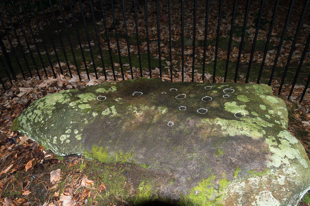
Come out of Ilkley/bus train station and turn right for less than 50 yards, heading left up towards White Wells. Go up here for less than 100 yards, taking your first right and walk 300 yards up Queens Road until you reach the St. Margaret’s church on the left-hand side. On the other side of the road, surrounded by trees is a small enclosed bit with spiky railings with Panorama Stones 227, 228 and 229 all therein: the least-decorated one on the left being the one we’re dealing with here.
Archaeology & History
This is another of the caged Panorama Stones, found within the awful spiked fencing across from St. Margaret’s Church, just out of Ilkley centre. Originally located ¾-miles (1.2km) WSW of its present position in Panorama Woods (at SE 10272 46995), along with its petroglyphic compatriots in this cage, the carving was moved here in 1890 when a Dr. Little—medical officer at Ben Rhydding Hydro—bought the stones for £10 from the owner of the land at Panorama Rocks, as the area in which the stones lived was due to be vandalized and destroyed. Thankfully the said Dr Little was thoughtful and as a result of his payment he had some of the stones saved and moved into their present position.
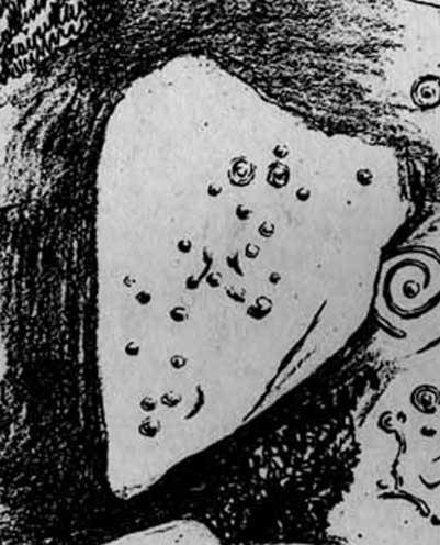
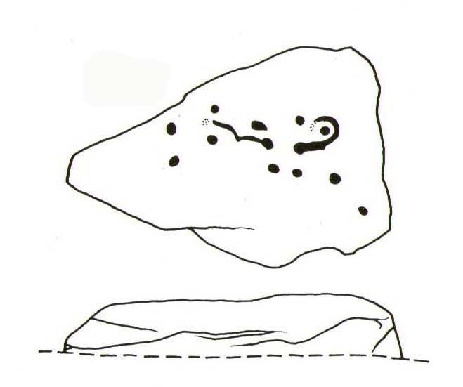
Original location of stonesJ.T Dale’s 1879 sketch
It was first described by the northern antiquarian and petroglyph pioneer, J. Romilly Allen (1879) , who saw it in the now-destroyed “rough inclosure”, as he called it, along with the other stones now in the same Ilkley ‘cage’. Its present position does it no justice whatsoever in terms of its original position. It was ostensibly a rocking stone: this seemingly trivial-looking boulder was sat on top of the much-cropped Panorama Stone 228 (a yard east of the three in this outdoor cage). Allen (1879) was fortunate enough to have seen the stone before it was uprooted, telling us how this topmost stone, “has eleven cups, wo of which are surrounded by single rings.” The modern archaeologist John Hedges (1986) told it to be in a “bad state,” with “very worn carvings, fourteen cups, one with partial ring and groove.” Its situation deteriorated further, as stated by rock art students Boughey & Vickerman (2003), who noted,
“medium-sized, roughly triangular rock, its surface recorded as in a bad state in 1986 and now (2002) even worse. Fourteen cups, one with partial ring, one groove.”
And its condition isn’t helped by its inaccessibility, when groups like the ‘Friends of Ilkley Moor’ or the local archaeologist should be at least annually cleaning this and the adjacent carvings. If they’re incapable, there are sincere people in antiquarian, history and pagan groups who would probably help out…
John Hedges 1986 sketchFaint cupmarks visible
In truth, this carving cannot be seen in isolation, nor merely reduced to a numeric catalogue in some rock art corpus. We must contextualize its relationship with the once much-larger multiple cup-and-ring stone on which it sat and then see it as it was in the landscape. Originally of course the rocking stone was Nature’s very own creation. As humans began migrating over and eventually occupying this once-wooded arena, the rocking stone became intimately related with animistic magickal rites and, over time, petroglyphs began to be etched upon the stone. Most probably the flat underlying rock surface was carved upon first, and a symbiotic relationship was forged between Earth’s surface and the small rocking stone, both of which were used in oracular and other rites. Over centuries, as the cups and rings on the earthfast stone grew, the mythic status of this small rocking stone allowed for the encroachment of carvings, and eventually cup-marks began to be etched upon it too. Later still, as the neolithic period moved into the Bronze Age, the people began to build a low-walled stone enclosure around this and the nearby multiple-ringed carving – similar to the multi-period enclosure at Woofa Bank and other sites on these moors. It was all a very long and gradual process.
In truth, the mythic status of this once-impressive site would have been maintained—in one form or other—well into the medieval period. But that’s another matter altogether…
Bennett, Paul, The Panorama Stones, Ilkley, TNA: Yorkshire 2012.
Bennett, Paul, Aboriginal Rock Carvings of Ilkley and District, forthcoming.
Boughey, Keith & Vickerman, E.A., Prehistoric Rock Art of the West Riding, WYAS: Leeds 2003.
Cowling, Eric T., Rombald’s Way, William Walker: Otley 1946.
Downer, A.C., “Yorkshire Archaeological and Topographical Association,” in Leeds Mercury, August 28, 1884.
Eliade, Mircea, The Sacred and the Profane: The Nature of Religion, Harcourt, Brace & World: New York 1959.
Hadingham, Evan, Ancient Carvings in Britain, Souvenir Press: London 1974.
Hedges, John, The Carved Rocks on Rombald’s Moor, WYMCC: Wakefield 1986.
Heywood, Nathan, “The Cup and Ring Stones of the Panorama Rocks”, in Transactions Lancashire & Cheshire Antiquarian Society, Manchester 1889.
Speight, Harry, Upper Wharfedale, Elliott Stock: London 1900.
Acknowledgements: With huge thanks to both Dr Stefan Maeder for help in cleaning up the stones; and to James Elkington for allowing use of his photos in this site profile.


")
")