The huge Pendreich Muir monolith, with Dumyat in the background
Nearly 600 yards west of the old Sheriffmuir Road (between Bridge of Allan to Greenloaning), you’re best approaching it up the zigzaggy lane from above Stirling Uni until it levels out beyond the main wooded area where the hills open up on either side of you. There’s a little touristy parking spot further along the road, just below a small wooded bit. Go past this and look out for the small peaked hill nearly a half-mile NW on your left. Take whichever footpath you fancy (if you see one) and get to the top of that hill!
Archaeology & History
This is a wonderful spot, located at the highest point on this small moorland region on the western edge of the Ochil Hills. I haven’t found too much written about this once proud, but now fallen monolith — which seems unusual considering its size, cos it’s huge! It would have stood out and been visible for miles around. Quite when it was felled, I cannot find. The only info I’ve got here (Royal Commission 1963) tells:
“Lying recumbent on a grassy patch among the heather, it is a four-sided pillar measuring 13ft in length, a maximum of 4ft 6in across the wider side, and a maximum of 1ft 6in across the narrower side.”
In enquiring about the nature of this stone a few years ago, a local chap who called himself ‘Wharryburn’ wrote to say, “I believe the laid-out stone is a fallen standing stone. My grandfather was gamekeeper at Airthrey Estate and responsible for the shooting on the moor there he passed it to my father etc… It’s the local volcanic stone, not an ice-dropped erratic. There are also a few biggish stones at points around that I tried to make some sense out of a few years ago, but no luck.”
The great hill of Dumyat rises to its east; a short distance north is a megalithic stone row with its upright Wallace Stone; whilst the overgrown prehistoric cairns of Pendreich 1, 2 and 3 live on the small hillocks a few hundred yards to the south.
References:
Royal Commission on the Ancient & Historical Monuments of Scotland, Stirlingshire – volume 1, HMSO: Edinburgh 1963.
Follow the directions to reach the Dumpit Hill A circle. From here walk about 100 yards ENE till you see an arc of small upright stones. If the heather’s in full growth it’s highly unlikely you’ll see anything; but if the heather’s been burnt away, the site’s worth looking at.
Archaeology & History
As with the small companion Dumpit Hill A circle more than 100 yards to the southwest, this site of similar dimensions was first reported by Arthur Raistrick in 1963, and then described — albeit briefly — in H.G. Ramm’s “Yorkshire Archaeological Register” for 1964, as “33ft in diameter. One third of the circle robbed but other stones standing.” And apart from that (with a repeat of the same info in Burl’s [2000] magnum opus) little else has been said. But there’s quite a bit more to this place than what our mentors have written…
Northern arc of circle, with stones A, B, C & DDumpit B Stone Circle (white sticks showing position of stones)
In a team visit to the site last week, it was Paul Hornby who called our attention to Dumpit Hill B. Thankfully the heather had been burnt back several months earlier, fortunately allowing us a better assessment of the place than Mr Raistrick’s initial survey forty years ago. Instead of just the 3 stones that he found here, we uncovered a near-complete ring of eight stones, arranged in a pretty decent circle (Alexander Thom would have classed it as a Type 1 circle). Paul’s attention was first drawn to an arc of three obvious upright stones and another laid down along the same arc. This arc then turned out to be a semicircle when he found another stone laid half-covered in the peat.
Western stones D & EStone F
But then it seemed, if this was an authentic stone circle, we were gonna struggle to see the rest of it as the deep heather had grown up over the southern side of this semi-circle of stones. But thankfully, with just a little bit of stomping on the ground in the right areas, three other stones of similar size and stature were located and within just a few minutes this small arc of stones had become a full prehistoric ring — except perhaps on the eastern side, where there was a distinct gap in the monument. Michala Potts and Paul did come across a couple of stones in this “missing” section, but they were just small rocks and didn’t account for an expected 9th stone. If such a stone ever stood at this eastern point in the circle, it remains unfound.
Two of the stones (G & H) that were initially covered in heather, after we’d carefully peeled the vegetation back, had what seems like small packing stones at one end, where it seemed obvious they had stood upright. It was tempting to carefully stand each stone back up into position, but we managed to overcome the temptation! None of the stones are higher or longer than 3 feet. At least three of them seemed to have been set along their longer axis rather than being set in the tall upright position — but again, this needs verifying by excavation. (With good evidence, some students posit that upright stones are male; rounded, wider stones are female — though such a lay-out here seems unlikely)
Stone GStone H
An additional curiosity was found in the middle of the circle, where there was a small but distinct scattering of stones, very much like a denuded cairn. If this turns out to be the case (as seems likely) it’d mean a new classification for this monument. We could do with having another look at this place the next time the heather’s been burnt away, enabling us to find out more about its nature and function.
…And if you walk west down the slight slope, over the couple of small drainage-ditch streams (which they really should stop cutting into our moorlands) and then up the slight slope towards the trackway, stopping some 20 yards before it, you’ll find you’ve walked right into the middle of a previously undiscovered Bronze Age enclosure, or settlement: the Dumpit Hill enclosure. It’s pretty impressive aswell! (more on that in due course)
References:
Burl, Aubrey, The Stone Circles of Britain, Ireland and Brittany, Yale University Press 2000.
Ramm, H.G., “Yorkshire Archaeological Register, 1964,” in Yorkshire Archaeological Journal, part 163, 1965.
ACKNOWLEDGEMENTS: Huge thanks again to Dave Hazell, Paul Hornby and Michala Potts in seeking out & helping with this and the adjacent sites!
From Grassington, head east along the B6265 road for a mile or so, thru the hamlet of Hebden and, once up the hill on the other side of the village, take the track up your left and walk up until the land just about levels out and the moorland opens up on the right-hand side of the track. If you’ve got the trackway which takes you to Scar Top House on your left (where the walling breaks), head straight into the heather and walk about 150 yards NE, keeping your eyes peeled for a singular upright, less than 3ft high. Once here, check the small overgrown ring you should be stood in!
Archaeology & History
A relatively small site that can be difficult to see when the moorland heather’s in full growth — but it’s in a lovely setting, with a hidden view of the hills for nearly 360°, yet quietly hidden from prying eyes until you’re all but upon the place. Although it has a likely Bronze Age pedigree (it aint yet been excavated), it was ignored by the confines of written history until Arthur Raistrick brought it back to life in a brief note in the Yorkshire Archaeological Journal of 1965 when Mr H.G. Ramm told what he’d found, described it simply as,
“32ft in diameter, 5 stones still stand leaving spaces where other stones have been taken for walling. A large stone is flat at the centre.”
Alignment east: ring, outlier, human, hill!
And that’s that! No doubt the remarks about some stones taken from here to be used in some walling were told Raistrick by a local, but he says no more about this.
The main feature to see in this small ring is the flattish, wide upright, less than three-feet high, on the eastern side. A smaller upright stands in half-boggy Juncus grasses as you spin round towards the north, with a smaller stone laid on the ground in between. Originally it appears there were at least eight standing stones making up this circle. If you walk around it you’ll make out several of the other stones laid down. About 30 yards due east of the tallest upright in the ring is another small outlying standing stone. And, less than 100 yards northeast from this outlier, we come across the equally small, little-known stone circle of Dumpit Hill B…
References:
Burl, Aubrey, The Stone Circles of Britain, Ireland and Brittany, Yale University Press 2000.
Dixon, John & Phillip, Journeys through Brigantia: volume 2 – Walks in Ribblesdale, Malhamdale and Central Wharfedale, Aussteiger: Barnoldwick 1990.
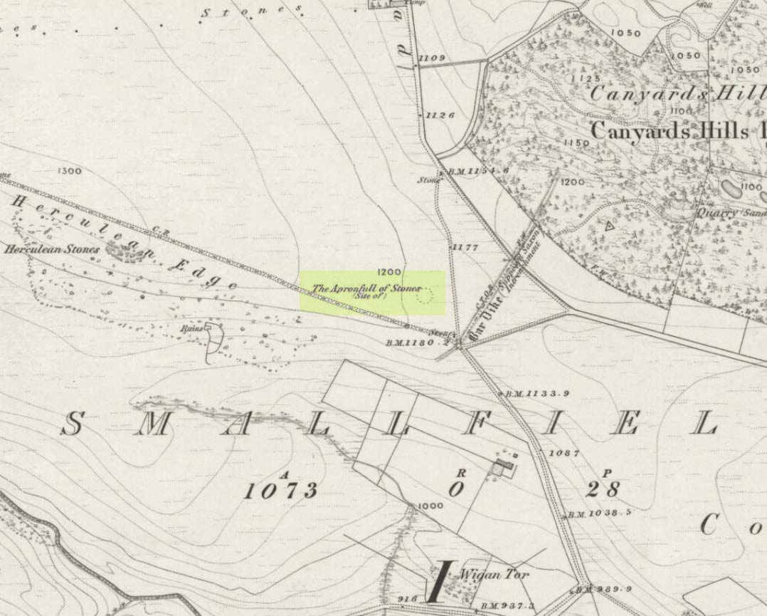
This was another example of the many giant cairns that scatter the upland moors on the Pennines, but much of it has been destroyed, with some halfwits in recent years cutting a track right through whatever remains there might have been! It was first described in John Watson’s (1776) essay on the local antiquities of Bradfield and district where, in relative conjunction with the curious Bar Dike, he told that “this is not the only curiosity on this common.” He continued: “there is on one part of it a large carnedde, called by the country people the Apron-full of Stones”, where he conjectured there laid a British tribal chief after he’d been slaughtered by the Romans. This might have been the folklore of the place, but we know such places were thousands of years earlier than the Romans.
It was later described in Joseph Hunter’s Hallamshire (1819) as a giant barrow, or ‘vast carnedde’, even then in the past tense; but some recent investigation here found “a few small stones and some lumpy turf which looked to be covering a few clumped stones.” The site requires further investigation by local people to assess the state of damage inflicted on this once great tomb.
Folklore
Said to have been the site of a local battle in ancient times; this is also another site which, as A.H. Smith (1961) tells, “is explained in folklore by tales of the devil undertaking some major building project and tripping up, only to deposit his apronful of stones” here. Does anyone out there have any more info on this place?
References:
Hunter, Joseph, Hallamshire: The History and Topography of the Parish of Sheffield in the County of York, Lackington: London 1819.
Smith, A.H., The Place-Names of the West Riding of Yorkshire, Cambridge University Press 1961-63.
Watson, John, “An Account of some Hitherto Undescribed Remains of Antiquity”, in Archaeologia, volume 5, 1776.
This lovely-looking 5-foot tall standing stone, marking an old boundary line in the Muasdale parish, is a curious one with elongated cups, some of which have the appearance of natural beach-side erosion caused by molluscs — unlikely though it may be. It first appears to have been described in an early PSAS article by Duncan Colville (1930), who told us:
“The writer was informed by the Rev. D.J. MacDonald, the minister of the parish, of the existence of this cup-marked stone forming a gatepost in the boundary wall between the arable and hill ground on the farm of Gaigean. The gate referred to is situated on the top of a steep bank on the south side of a small stream, a short distance uphill to the east of the farm steading of Gaigean. The front of a stone is now set an angle of about 45° to the ground facing almost southwest (105° magnetic across the face). Underneath the stone is another boulder similar in size, with several smaller stones wedged between the two, thus preventing further inspection.”
The North Beachmore stone
Some years later when the Scottish Royal Commission (1971) lads described the site in their Kintyre survey (monument no.97), they gave a more detailed description of the cup-and-rings, saying:
“The markings consist largely of plain cups, but one cup is accompanied by a partial single ring which measures 0.11m across. At the foot of the lower half of the stone four cups linked by broad gutters form a curious branched pattern, and a similar combination of three cups and gutters occurs in the upper half, while in two other instances a pair of cups are joined by a short straight channel to form a dumb-bell figure. The remainder of the markings comprise twelve oblong or kidney-shaped hollows measuring up to 0.15m in length by 0.064m in breadth, and thirty-one plain cups ranging from 0.038m to 0.076m in diameter, the largest being 0.019m deep.”
References:
Colville, Duncan, “Notes on the Standing Stones of Kintyre” in Proceedings of the Society of Antiquaries, Scotland, volume 64, 1929-30.
Royal Commission on the Ancient & Historical Monuments of Scotland, Argyll – volume 1: Kintyre, HMSO: Edinburgh 1971.
From the Askwith Moor car-parking spot, walk up the road (north) for 350 yards and go thru’ the gate on the left-side of the road, up along the track onto Askwith Moor. To get to it, walk on the footpath towards the trig-point on Shooting House Hill from the Askwith Road. Between 50-100 yards before the trig, walk into the heather to the right. Just 5-10 yards off the footpath, it’s there! If the heather’s grown back, don’t even bother looking for the place!
Archaeology & History
Although I add this as the remains of a small Bronze Age or neolithic settlement — which was found on August 3, 2005, in the company of Richard Stroud — subsequent walks up hereabouts in the surrounding heather has shown that, far from being a small independent site, it was part and parcel of a much greater prehistoric landscape all round here: with the remains on High Low Ridge immediately west; the cairnfields of Askwith Moor and Snowden Crags south and east; and numerous cup-and-ring stones scattered all over the place here. It’s a veritable minefield of archaeological remains, from the mesolithic to the Iron Age all over these moors!
Barely visible remains of wallingMore of the walling
We came wandering up here looking for another of Eric Cowling’s “lost circle” sites described in 1946, near Shooting House Hill, which Graeme Chappell and I looked for ten years previously without success. But on the August 2005 visit, much of the heather had been burned away. Instead of the lost circle however (which remains unfound, though something suspiciously like it is close by) we came across a well-defined, though small settlement complex. The walling of two well-defined near-rectangular structures emerge either side of a reasonably large boulder. Beyond these is further walling and what seems a well-defined hut-circle less than 10 yards away. Like many other sites on these moors, the walling seem to have been pretty much robbed for building grouse-butts. (hence the pictures here looking a bit sparse of stone!) Subsequent investigation found more neolithic walling which ran into the deeper heather — so it has been difficult to work out the full scale of it all.
The landscape from here stretches way off. To the eastern horizon (not far away) is the legendary Almscliffe Crag, with the rising hills of Rombald’s Moor due south; whilst far to the sunsetting west rises the great contours of Pendle Hill, to which legend relates some of the witches of the Fewston Valley, a mile below…
References:
Cowling, Eric T., Rombald’s Way, William Walker: Otley 1946.
Travel up the B6265 (Skipton to Grassington road) for a mile, watching on the small hills on your left (western) side, and then take the left turn up to Sandy Beck. You can’t miss the place!
Archaeology & History
Rough Haw, looking west
My first view of this place was from the hills east of here, atop of one of the great rock outcrops on the edge of Embsay Moor. The very first impression it gave me was – “That’s a bloody hillfort!”: an obvious worked rounded hill, with ridges typical of such monuments. Subsequent investigation found that there were extensive remains of walling, more typical of the Iron Age period than the neolithic (which some modern archaeologists have proposed), clearly visible around the edges of this great hill. The structure of the site is similar in size and design to the remains at the nearby Horse Close Hill above Skipton, aswell as another (officially unknown) site closer to Keighley. A large overgrown cairn rests on the southern side of the hill, seemingly more of archaic import than a mere clearance or marker point. But I may be wrong…
Very notable at this site are the profusion of springs emerging from all round Rough Haw: the blood of seven such water sources comes from its edges on all sides and would obviously have been of some importance here.
References:
Dixon, John & Phillip, Journeys through Brigantia – volume 1: Walks in Craven, Airedale and Wharfedale, Aussteiger Publications: Barnoldswick 1990.
Many ways to get here, but you’ve gotta amble off-path through the woods to eventually find it — but it’s not difficult. From Kilmartin village head to Slockavullin and walk up the winding track which takes you towards the Ballygowan cup-and-ring stones, but follow it into the woods instead. The OS-map’s gonna be your best guide here. I first visited this spot from the south and ambled about, aimlessly at times for several hours, after I’d first been to the great ruined mansion of Poltalloch. Well worth checking out if you enjoy finding allsorts!
Archaeology & History
The old tomb is actually a few hundred yards beneath the small rocky summit of Barr a’ Chuirn, with the overgrowth of the woods imposing itself upon it. The Scottish Royal Commission report (1988) told that there was a large seat built here in the 19th century called the Lady’s Seat, and actually set up on the cairn itself so giving groovy views all round to those who came here. The Seat was made from large slabs of stone, which may originally have come from the old tomb. An excavation here in the mid-19th century,
“found the remains of two cists and some burnt bones, with a ‘skeleton of later date, between the two cists, but probably put there by the men who destroyed the cairn.’ In 1929 Craw re-examined the site and found that the central cist had chambered and grooved slabs. This cist is aligned ENE and WSW, and the E end-slab is now missing; the cist measured about 1m by 0.5m and about 0.3m in depth internally. The northern side-slab is grooved at the west end.”
References:
Royal Commission on the Ancient & Historical Monuments of Scotland, Argyll: volume 6 – Mid-Argyll and Cowal, HMSO: Edinburgh 1988.
Cup-and-Ring Stone: OS Grid Reference – NC 635 384
Archaeology & History
This small cup-marked stone came to light following the work of Mr Angus MacKay of Sutherland, more than 100 years ago. In his essay in the Scottish Antiquaries journal (1905), he wrote the following:
Grumbeg carving
“A cup-marked stone was found by me in the burial place of Grumbeg, Strathnaver, September 1905, standing upright at the head of a grave, and showing about 6 inches above the ground. It is evidently a fragment of a larger slab: its extreme length is 20 inches, and it is about 15 inches at its broadest part. The upper three circles are 2.5 inches in diameter and 1.5 inches deep, very symmetrically hollowed out, but the fourth and lower circle is shallow and indistinct. As the stones covering the other graves are for the most part what is called rough mountain slabs, it seems to me that this cup-marked fragment was found in its present condition elsewhere, and placed here to conveniently show a lair.”
If such was the case, a good contender might be the denuded chambered cairn close by.
Cup-and-Ring Stone: OS Grid Reference – NT 251 696
Archaeology & History
Braid Hills carving
This is a fine-looking old cup-and-ring stone! Although no longer in situ (one of those really important golf courses needed to be built, so it had to go!), the 3 or 4 cup-and-rings seen here, carved at the end of what look like some sort of ‘stalks’, emerging from a distinctive radial under-curve, gave me a somewhat anthropomorphic impression of chaps in a boat — perhaps sailing into the Firth o’ Forth a short distance away! The Scottish Royal Commission (1929) report said the following of the stone:
“In 1897 a boulder of white sandstone with cup-and-ring markings on its surface was discovered on the Braid Hills golf course, and it was later presented to the National Museum of Antiquities. The stone measures almost 3 feet by 1 foot 9 inches, by 1 foot thick and is roughly oblong. The markings comprise seven cups in all, and at least three of these are completely surrounded by a ring and cut by a radial channel.”
Although nothing was said in the RCAHMS account, the stone gives one the impression it was associated with a tomb. And I know it aint the same, but when I first saw this carving, it reminded me of the Ri Cruin carving in Kilmartin, Argyll. It’s the potential “boat” feature that did it for me!
References:
Royal Commission on the Ancient & Historical Monuments of Scotland, Inventory of Monuments and Constructions in the Counties of Midlothianand West Lothian, HMSO: Edinburgh 1929.