Another off-the-beaten track site! Follow the directions to reach the Middleton Moor 001 carving, then walk due east for about 500 yards until you reach the distinct footpath that’s the Roman Road. Once here, zigzag along its edge on the western side, up and down hereabouts. Keep looking around till you see the stone shown in Richard’s photo here!
Archaeology & History
First found in April 2005, this medium-sized flattish stone is just 10 yards west of the prehistoric trackway which cuts across the moors — later used as a Roman road — on Middle Gill Bents. A somewhat simplistic design, it was found by Richard Stroud when we were exploring some of the many other carvings up here, and looking for previously unrecorded ones hiding in the heather. Carved onto this stone are eight, perhaps nine cup-markings, with grooved lines connecting at least two of them. That’s it!
From the back of Moor End Farm on the south-side of Langbar village, follow the Long Ridge footpath up onto the moor. Walk along the path until its starts dipping down again, onto the moor proper and where another footpath crosses and goes down into the small valley of the Dryas Dike stream, follow it – though only for about 75 yards, heading diagonally into the heather slowly towards the stream. You’re getting close!
Archaeology & History
Crude drawing of CR441
Yet another small carving found amidst a decent cluster of cup-and-rings and other archaeological remains near the top of Dryas Dike, this stone was first described in the Boughey & Vickerman (2003) survey. It’s located about 10 yards below Middleton Moor CR-440, above the stream of Dryas Dike. It’s a simple design, comprising of a central groove with a cup at either end and several other cups either side of this central line. (cheers to Richard Stroud for use of his photo).
References:
Boughey, Keith & Vickerman, E.A., Prehistoric Rock Art of the West Riding, WYAS 2003.
From Ilkley go up to Middleton and from there go up Harding Lane and, where the road bends left a track goes straight north onto the moors. Go up this until you’re onto the moor proper. Keep going until you’re following the line of walling, where a small stream is trickling right by your right-hand side. Follow this to its source a coupla hundred yards up. Stop!
Archaeology & History
Middleton Moor CR483: single cup-and-line
First mentioned by Stuart Feather in 1965, this simple cup-marking has a long line squirming away to the edge of the rock on which it’s carved. The cup-marking is some 3 inches across and about ½-inch deep, with the long line about 24 inches long. There’s really nowt much to look at here unless you’re a real cup-and-ring freak — though note that the carving occurs on a broken piece of stone just where a spring of water emerges from the ground. Some archaeo’s have a notion that sometimes our cup-and-ring stones have some sorta relationship with water — though they’re not into sticking their necks out and saying anymore than that! And of course, some carvings obviously relate to water. This one here is a strong contender, with the long wiggly line perhaps representative of the stream running from its source, which itself is the cup-mark.
However, we might just aswell surmise that the carving here was executed by some bored teenager, just testing out his first antler pick, or flintstone, telling his mates, “I woz ‘ere!”
References:
Boughey, Keith & Vickerman, E.A., Prehistoric Rock Art of the West Riding, WYAS 2003.
ather, Stuart, ‘Cup and Ring Boulders,’ in the Cartwright Hall Archaeology group Bulletin, 10:7, July 1965.
Best approached from the south, up Hardings Lane, then where its bends and the track of Parks Lane goes onto the moor, follow it. Onto the moor, keep on the track as it follows the walling until you reach the gate on your right. From here you’re close: head into the grasses and heather (left) not far off the western edge of the footpath at the eastern end of Dryas Dike. Look around!
Archaeology & History
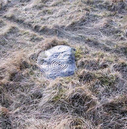
This lovely looking carving “quite near to the footpath and enclosed fields above March Ghyll reservoir,” was first described by Stuart Feather. (1965) It can be found on a small flat stone and is easily obscured if the grasses are long – but it’s worth searching for. It’s an archetypal cup-and-ring stone, consisting of a cup-and-five rings, a cup-and-ring, and a cup-and-three rings — though they are rather faint and can be missed in bad light. As with other carvings, it’s best to splash water over it (as me & Richard did in the photo above) so you can see it a bit clearer. Feather (1965) told us:
“The symbols are very fine, consisting of three cup-and-rings. One of them, a quadruple, concentrically-circled cup with part of a fifth, unfinished ring. The cup is very shallow, 1 inch across, and the circles…½ inch wide and shallow, with an overall diameter of 8 inch for the four circles; 9 inch with the other unfinished section. The single cup-and-ring has a cup ¾-inch in diameter, ½-inch deep and a 4-inch diameter ring somewhat broader than the other rings on the rock and abutting on the north side against a slightly raised part of the rock surface.”
The triple-ringed cup is of similar dimensions to the larger example, with the cup being 1½ inch across and deep, with the circles being 7 to 7½-inch across.
About a half-mile northeast of here is the old Langbar Stone where I got the distinct impression that the same person was responsible for both of these carvings. God knows why!
References:
Boughey, Keith & Vickerman, E.A., Prehistoric Rock Art of the West Riding, WYAS 2003.
Feather, Stuart, ‘Mid-Wharfedale Cup-and-Ring Markings: No.32-3, Middleton Moor,’ in the Cartwright Hall Archaeology group Bulletin, February 1965.
Just below Black Hill in the Middleton Moor Enclosure, little more than 10 yards east of the footpath on the east side of Loftshaw Gill, the slope drops down and into a slight ‘bowl’ in the landscape. Here it is!
Archaeology & History
This is a previously undiscovered prehistoric settlement, enclosure, or something along those lines! We came across it in April 2005 and is found amidst the mixed heather and bracken and has a scattering of small stones, as if in the wake of a dried stream from bygone times. But whatever stream might once have been here, it’s long since fallen back to Earth — but at a point where a few rushes (Juncus conglomeratus) can be seen we find the aged remains of a large oval enclosure.
Similar in form to the other remains located up here by Eric Cowling (1946) in the 1930s and ’40s, when Richard Stroud and I first found this, structural remains of distinct lengths of walling were visible – but once the vegetation started growing back here again, it was almost impossible to discern.
Faint remains of enclosure walling
The main archaeological remains comprises of an oval-shaped structure, with what seemed liked a distinct Bronze Age note stamped on the walling — though it could be earlier, but without excavation it’s impossible to say. Most of the walling was just above ground-level, making it difficult to appreciate in the photo. It measures approximately 40 feet north-south and 33 feet east-west. The walling itself averages between 18-24 inches wide and was no more than one-foot tall at the highest. Near the middle of the enclosure there were further sections of walling indicating different ‘rooms’ in the overall structure of things here.
Like I say, we unfortunately couldn’t get a decent image of this site cos the vegetation was already covering it up. So if you wanna see it, gerrup there soon after the heather burning’s been done here — otherwise it’s gonna be at least another year before you getta chance to see anything. In Richard Stroud’s photo here, you’re looking at the bottom curve of the enclosure. You can just make out the line of walling near the centre of the picture, and two-thirds the way to the right you can see the enclosure wall curve closer to the bottom of the photo. (the site obviously requires a much better assessment from someone far more competent than me!)
References:
Cowling, E.T., Rombald’s Way, William Walker: Otley 1946.
Follow the same directions to reach the Middleton Moor carvings, numbers 436 and 437, up along the footpath. This is the easiest to find as it’s right beside the footpath – as Richard Stroud’s photograph clearly shows.
Archaeology & History
Drawing of CR-435Middleton Moor CR-435
Near a cluster of other cup-and-ring marked rocks, this decent example can be found besides what may be a prehistoric trackway running roughly east-west over the Long Ridge to Foldshaw Ridge. Amazingly, this stone was never previously catalogued until Boughey & Vickerman’s survey in 2003. Just goes to show what y’ can find if y’ gerrof yer arses and look for yerselves! Comprising at least thirty cups and several lines, one faint cup-and-ring is discernible on the western edge of the stone.
If you walk westwards, back up to the hilltop from here (only a couple of hundred yards), a single upright stone which some might consider megalithic, stands right before your eyes! An excellent spot!
References:
Boughey, Keith & Vickerman, E.A., Prehistoric Rock Art of the West Riding, WYAS 2003.
Follow the same directions to get to the Middleton Moor Carving 437, along the Ridge Way footpath, and this stone is just a few yards away.
Archaeology & History
This all-but insignificant carving was first described in Boughey & Vickerman’s (2003) survey, as a “small rough grit rock sloping into turf” with what may be two faint cup-markings etched on its surface. Unless you’re a bittova rock-art fanatic, this might not be of much interest to you! (thanks to Richard Stroud for use of his photo!)
References:
Boughey, Keith & Vickerman, E.A., Prehistoric Rock Art of the West Riding, WYAS 2003.
Head for the gorgeous little hamlet of Langbar, a few miles northwest of Ilkley. Less than ½-mile before the village, keep your eyes out for the footpath bearing east onto the moors at Moor End Farm (right-hand side of road if you’ve travelled from Ilkley). Walk along the Long Ridge footpath to where the fields on your left finish and the moorland proper opens up. Hereabouts, check the stones in the heather to your right! If you amble about looking, you’ll find it!
Archaeology & History
Crap drawing of CR-437
This is another one of those carvings for the purists amongst you. Less than ten yards off the footpath on Long Ridge is this medium-sized rock with several cup-marks, and lines, on both its top and vertical faces. Boughey & Vickerman (2003) think there to be at least five cups on the top, with perhaps nine on the vertical east face, though some of these are debatable. (the drawing I’ve done is from their book)
References:
Boughey, Keith & Vickerman, E.A., Prehistoric Rock Art of the West Riding, WYAS 2003.
This is a lovely-looking stone in the pictures and diagrams, and is quite easy to find close to the meeting of the footpaths along Foldshaw Ridge and the Parks Lane track, near the gate. It lays at an angle in the short grass just by the path…but to me, all is not what it seems…
Archaeology & History
This was a carving I saw pictures of in the 1970s, and always thought it would be something to behold – but my first impression here wasn’t just disappointment, but the most distinct thought that the carving’s modern! It’s a real oddity. For a start, the cups in this carving are very small – much smaller than the countless authentic carvings on the moors here and at Ilkley to the south. And after seeing thousands of these things, this one didn’t seem at all right.
The lack of erosion on the cups may be due to it once accompanying a prehistoric tomb some time in the past, though no such remains have been noted here. However, at carved stones Middleton Moor 001 and Middleton Moor 2 — less than 100 yards to the east — cairns are in evidence next to the petroglyphs, indicating that this relationship occurs at some cup-and-ring stones in this small geographical region and, perhaps, explaining the ideosyncratic nature of this design.
But such speculation aside – the brief literary history of this stone is: first described by Stuart Feather in 1965 and illustrated by Sidney Jackson the same year. The rock art students Boughey & Vickerman’s (2003) described around sixty ‘cups’ etched onto the stone here, but they made no comment about either the odd nature of the cups or the possibility of it being modern. Perhaps it’s just me…
References:
Boughey, Keith & Vickerman, E.A., Prehistoric Rock Art of the West Riding, West Yorkshire Archaeology Service 2003.
Follow the same directions to reach the Pancake Stone, but about 100 yards west, following the footpath that runs along the edge of the ridge (towards the large Haystack Rock a few hundred yards west), watch out for these large seemingly split rocks, with one elongated length of stone by the pathside. You can’t really miss it!
Archaeology & History
Very little’s been said of this carving as it’s just one more of the many rocks with just a solitary cup-marking etched on top — as we can see in the photo. The cup-mark is near the bottom, southeast-ish portion of the rock and is plain to see.
(Note: I’m not 100% sure that I’ve got Boughey & Vickerman’s (2003) numbered carving correct here. They describe a carved rock very close by here as an “upstanding rock, part of a large split rock,” as their ‘number 326’ carving — which is roughly similar; though I’m not totally sure! No other single cup-marked stone is listed in their survey close by, so assume it’s the same one as in their work.)
References:
Boughey, Keith & Vickerman, E.A., Prehistoric Rock Art of the West Riding, West Yorkshire Archaeology Service 2003.
Hedges, John, The Carved Rocks on Rombalds Moor, WYMCC: Wakefield 1986.

 First found in April 2005, this medium-sized flattish stone is just 10 yards west of the prehistoric trackway which cuts across the moors — later used as a Roman road — on Middle Gill Bents. A somewhat simplistic design, it was found by Richard Stroud when we were exploring some of the many other carvings up here, and looking for previously unrecorded ones hiding in the heather. Carved onto this stone are eight, perhaps nine cup-markings, with grooved lines connecting at least two of them. That’s it!