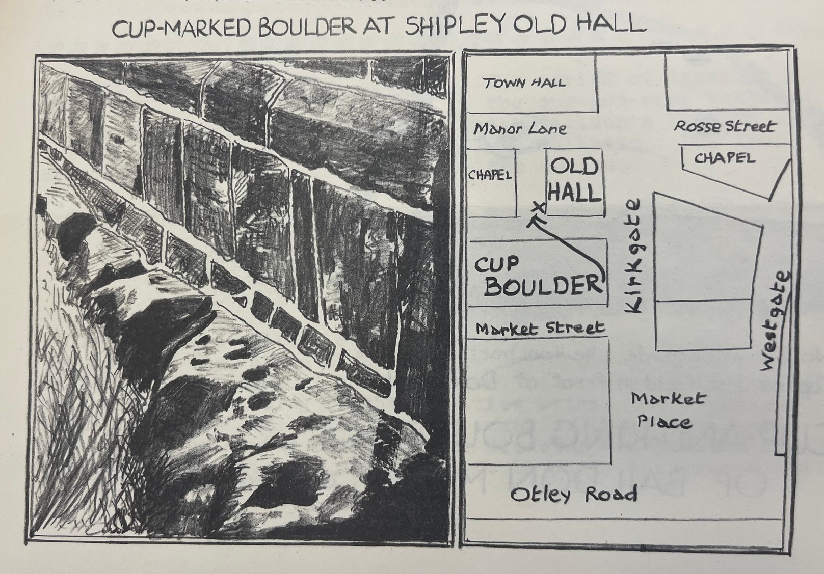
From Shipley town centre open market, take the Kirkgate road up to Saltaire, past the old town hall. On the other side of the road take the little path into the Bowling Club, in the trees (if you hit the church you’ve gone too far). Once standing in front of the bowling green itself, you need to walk along the left-side path. Two-thirds of the way down, now laid in the ivy-covered area below the old quarry face, you’ll find what you’re looking for.
Archaeology & History
I remember first seeking out this carving when I was still at school and wondering how the hell it got here – and believed it to be a fallen standing stone at the time! It seems that the stone was cut and readied for use as a gatepost instead, at some time long ago.
Close-up showing cups & linesIn its previous locale
The curious cup-marked stone has travelled about a bit, somehow. Formerly at the edge of a field in the grounds of Bradford Grammar School 3 miles away (at SE 1523 3583), the fella was then built into the wall of the now-demolished Shipley Old Hall, before reaching its present resting place at the edge of the bowling green. Consisting of around 16 cup-markings with carved lines seeming to link them here and there, it was first mentioned by the late great Sydney Jackson (1955) in an early edition of the Bradford Archaeology Journal. The carving was recently included in the Boughey & Vickerman (2003) survey, where they described it as,
“Medium-sized fairly smooth grit rock with coarse line down top, probably natural, evidence of quarrying on edge. Sixteen or seventeen cups, one with a groove out has a deeper cut within it and twelve of the others are linked in pairs by short grooves. This has been interpreted as feathering for quarrying, but the grooves are across the line of likely split, rather than along it.”
And for those of you who live nearby: if you check this out, see if you can locate an earthfast boulder near here which I recall having a cluster of distinct cup-marks running on top of the rock along one side. I couldn’t find it when I looked a short while ago, it’s not in the archaeology survey lists, and it remains lost—in the heart of Shipley no less!
References:
Boughey, Keith & Vickerman, E.A., Prehistoric Rock Art of the West Riding, WYAS: Wakefield 2003.
Jackson, Sydney, “Cup-Marked Boulder, Shipley Old Hall,” in Bradford Cartwright Hall Archaeology Group Bulletin, 1:10, 1955.
Follow the same directions as if you’re visiting the largest and most ornate of the Buck Woods carvings. From here, about 10 yards ahead of you, roughly north, you’ll see another stone, less than half-size of Buck Woods 1, moss-covered and not rising too much out of the Earth. It’s not difficult to find once you’ve located the largest of the Buck Woods stones.
Archaeology & History
A cup-and-half-ring
Another of the small cluster of little-known prehistoric carved stones in this woodland on the edge of Bradford, not in the Boughey & Vickerman (2003) survey. This however is possessed of a cup-and-half-ring, with other seemingly carved ingredients fusing onto natural aspects of the rock. The design is found on the highest part of the stone; and whilst the main cup is easy to make out, the encircling half-ring is slightly troublesome.
…and from another angle
There are two distinct lines running down one side of the rock, both seemingly natural, but they may have been added to—it’s difficult to say with any certainty. Certainly the one closest to the cup-and-half-ring has the carved line etched to meet the natural geological feature, as you can just make out in the photos here. There also seems to be other carved features surrounding the central design, with other marks round the main cup, almost suggesting that a complete ring was being made, but never accomplished. It’s an odd one. If I’d have stripped the moss from the stone I could have seen the design in greater detail, but I’ve gotta bittova soft spot for mosses and lichens, so left it alone!
Follow the same directions as if you’re visiting the largest and most ornate of the Buck Woods carvings. From here, walk 10 yards to the Buck Woods 3 carving, then about the same distance forward again until you reach the low lines of (what looks like) Iron Age walling running roughly east-west through the trees. Walk 10-20 yards east along the walling until a gap or entrance appears – and on the other side where the walling starts again, check the 2nd or 3rd rock along, beneath the mosses.
Archaeology & History
More simple cup-marks
There are no previous references to this small cup-marked stone, whose cups are on the topmost surface of the stone in this ancient stretch of walling (into which some vandal has recently carved his name, ‘Hunt’). It’s another one for the purists amongst you though, as we only have 2 or 3 cupmarks here, as the photos show – with just one which I can say is a certainty. Curiously the other two look, for all the world, as if they’re mollusc cups!—but considering you’re about 50 miles from the sea, this seems a little unlikely. Worth having a look at when you’re checking the other four carvings close by.
Follow the same directions as if you’re visiting the largest and most ornate of the Buck Woods carvings. Once there, notice the green field on the other side of the wall less than 50 yards away. Walk towards the wall, about 20 yards from the Buck Woods 1 carving, keeping your eyes peeled for a flat mossy stone. You’ll find it!
Archaeology & History
Close-up of the cups
A nice simple, almost cute cup-marked stone—not included in the Boughey & Vickerman (2003) survey—with three simple cups running almost in a straight line from the middle of this long stone to its outward, eastern edge. One of the good features of this and its associated carvings is the setting amidst which it’s found. We tend to associate these carvings with open moorland, where many now live, but when they were first carved they were surrounded by woodland and much more: important ingredients relevant to understanding the nature of these curious carvings…
A little-known early christian relic found in the driveway to East Riddlesden Hall was saved and propped up in the stable floor at the back. In 1984 however, the National Trust got round to moving it and bringing the relic to greater public attention by putting it on display in the great hall of the building. (I think you’ve gotta pay to go in and see the stone these days – which is a bittova pain if you just want to examine the carving)
Old photo of the carved stone (after Margaret Faull)
Measuring just 1 foot across and 2 feet high and carved on all sides, the design is all too familiar to those of you exploring early christian or late-Celtic art forms. Executed sometime between the 5th-10th century, on the main face of the cross we have the traditional ‘Celtic’ interlacing, with a bird-figure emerging on or around an early ‘cross’ symbol. There are a variety of interpretations of this, but none relate to any modern christian mythic structures. Indeed, we should cautiously reflect on the more pre-christian nature of this design: carved as it was at a time when the spirit of the natural world (animism) was endemic amongst all people. This carving would in some way reflect such implicit subjectivity, though perhaps have had emergent ideals relevant to the christian cult within it. However, we should be cautious about this christian idea, despite it being much in vogue by prevailing groups of consensus trance historians.
References:
Faull, Margaret L., “The Display of the Anglo-Saxon Crosses of the Keighley Area,” in Transactions of the Ancient Monuments Society, New Series no.30, 1986.
Balbirnie stone circle – with Marion checking it out!
Take the A92 road running north out of Glenrothes towards Freuchie and, after a couple of miles out of town, you’ll hit the B969 road on your left. Across from here on the other side of the road, you’ve just passed a small B-road that takes you to Markinch. That’s where you need to be! Go along there for less than 100 yards and turn first right, swerving along the tree-lined road for 200 yards or so. Watch out, just before the first house on your left, for a footpath which leads into the woods. Walk down it, barely 10 yards!
Archaeology & History
This is a lovely megalithic ring in a lovely setting – albeit a new one. The circle was originally positioned some 125 yards northwest of here and would have been destroyed, but was thankfully reconstructed by Fife Council before road-widening of the A92 was done. And the job’s a good one! But as Burl (2005) tells, this wasn’t the first time Balbirnie had been threatened with damage:
The southeast stones & cistsBalbirnie from the roadside, looking SE
“With some stones removed in the eighteenth century, dug into in 1883 when bones and sherds were found, damaged by trees, it was finally excavated and restored in 1970-71,” before the main road was built. Thankfully it’s still here – and an excellent stone circle it is! However, the reconstructed site here doesn’t show the circle in its entirety. Originally there were ten standing stones making up the ring, as opposed to the seven you can see today.
The site was built amidst the scatter of other larger, and once more impressive, mythically important monuments than the circle – but it’s as likely that the circle added more to the sacred dimensions of the region as a whole when it first came to be built. For on the other side of the A92 we can still see the denuded remains of the Balfarg Riding School Henge, with imitations of its internal upright posts resurrected into position to give an idea of what once stood inside the sacred enclosure. And then about 200 yards west of that, the gigantic Balfarg Henge is impressively surrounded by a modern housing estate, built with the henge in mind, with its outlying megaliths and internal level surface area graciously intact. It’s a truly impressive prehistoric area all round, although the Balbirnie stone circle was built some considerable time after the two henges had been done, many centuries later…
Before the circle was moved, the consensus profile of the site was that given by the Royal Commission (1933) lads following their visit here in June 1925, when they told it looked like this:
Royal Commission ground-plan, c.1933
“At the southern end of a small wood on the east side of the main road from Kirkcaldy to Falkland, about 180 yards south of Balbirnie Lodge, are the remains of a large circular cairn and of the setting of standing stones by which it was once surrounded… The circle, which has had a diameter of some 48 feet, has been composed of sandstone boulders. Four of these are still in place, but one other on the southeast has been slightly displaced, while against the stone on the northeast lie two large boulders, which apparently have been transferred to this position. Any other stones that may once have existed have been removed or destroyed. The greatest height above ground of any of those that survive is 5 feet 6 inches, while one, which rises no more than 2 feet, measures in circumference as much as 9 feet 9 inches at the base. The cairn itself seems to have been broken into at two points. No record of these excavations appears to be extant, but a number of fragments of cinerary urns from the site are preserved in the National Museum. These indicate that, as might have been inferred from its general character, the monument was sepulchral and dates from the Bronze Age.”
Sepulchral indeed. When the stone circle was excavated at the beginning of the 1970s by J.N.G. Ritchie (1974) and his mates, it was discovered this was a primary function of the site. As Burl (2000) wrote:
“At Balbirnie patches of cremated bone lay underneath some circle-stones. Whatever the ceremonies here they were interrupted when the site was converted into a cemetery. Four or five cists associated with a late beaker and a jet button were constructed within the ring. The date of about 1650 BC came from wood alongside the beaker. Stretches of low walling were put up between the stones forming a continuous barrier…analogous to the embanked stone circles elsewhere in Britain that seem generally to belong to a period in the mid-second millennium… But the first cists did not long remain undisturbed and were seemingly rifled when later cists were built that contained the cremations of women and children… One of these later cists held a food-vessel and a flint knife.
“The stone circle was further abused. A low cairn was piled over all the cists. Sherds of deliberately broken urns, one with barley impressions, were scattered amongst the boulders, intermingled with small coagulations of burnt human bone. This last phase at Balbirnie occurred late in the second millennium BC, for a C-14 determination of…1200 to 900 BC came from the land surface that had built up within the ring during the centuries while the stone circle remained open to the weather.”
Measuring 49 feet across at the widest, this flattened ellipse also possessed a curious rectangular section of laid stone, near the middle of this circle, almost ‘Roman-road’ like in appearance and covering about a quarter of the internal arena. It’s visible today at the reconstructed site and looks almost intrusive! Measuring some 11 feet by 9 feet, the flat stone surface has been suggested as a place where corpses were rested.
Also found within two of the tombs inside the circle were the cup-and-ring marked stones of Balbirnie 1 and Balbirnie 2, showing yet again the relationship that some of these carvings have with spirits of the dead.
References:
Burl, Aubrey, “Intimations of Numeracy in the Neolithic and Bronze Age Societies of the British Isles (c.3200-1200 BC),” in Archaeological Journal, volume 133, 1976.
Burl, Aubrey, Rings of Stone, BCA: London 1979.
Burl, Aubrey, The Stone Circles of Britain, Ireland and Brittany, Yale University Press 2000.
Burl, Aubrey, A Guide to the Stone Circles of Britain, Ireland and Brittany, Yale University Press 2005.
Denston, C.B., “The Cremated Remains from Balbirnie, Fife,” in Archaeological Journal, volume 131, 1974.
Ritchie, J.N.G., “Excavation of the Stone Circle and Cairn at Balbirnie, Fife,” in Archaeological Journal, volume 131, 1974.
Royal Commission on the Ancient & Historical Monuments, Scotland, Inventory of Monuments and Constructions in the Counties of Fife, Kinross and Clackmannan, HMSO: Edinburgh 1933.
Acknowledgements: Huge thanks to Marion Woolley for getting us out to see this and the related neolithic monuments. Cheers m’ dears!
Take the same directions as if you’re going to Dave’s Stone, to the eastern end of Rivock Edge itself. Then take less than 10 steps further onto the moor itself and you’ll see the stone pretty low down in the heather. (please note that grid-reference above needs revising)
Archaeology & History
…and looking straight down!
Found about 10 yards onto the flat ridge south of Dave’s Stone cup-marked stone, the vegetation covering this carving had only recently been brushed off when we revisited the place in 2012, by members of the Ilkley CSI team in their own survey of the area. As you can see, it’s a simple design of just two well-preserved cups on a small rounded stone. What may be the remains of a very faint ring arc is possible over one of the two cups. Nowt much more to say really!
From Cow & Calf Hotel head onto the moor above you, following the same directions to reach the ornately carved Idol Stone (and its immediate companions). Ahead of you on the same footpath, about 100 yards along, as it begins to slope up the hill further onto the moor, you’ll see a large upright pyramid-shaped stone, about 8 feet all, right at the side of the path. Y’ can’t miss it!
Archaeology & History
Deep cups & lines on top
Although ascribed as a cup-marked stone in usual surveys, the cup-markings on top of this rock are seemingly Nature’s handiwork. There is a possibility that cup-markings were carved into the top of the stone, many thousands of years ago, but due to the centuries of wind and weathering, we cannot in anyway assess the curvaceous bowls and lines running across and from the top of this rock to be artificial.
Folklore
The name ‘Idol Stone’ seems to have come about as a result of the judaeo-christian Victorian obsession of satanic idolatry in all things natural – which many of them still fear. Sadly there are no early accounts of practices of idolatry at this rock, until it was used by chaos magickians in the formative years of that Current in the 1980s.
References:
Bennett, Paul, The Old Stones of Elmet, Capall Bann: Milverton 2001.
Boughey, K.J.S. & Vickerman, E.A., Prehistoric Rock Art of the West Riding, WYAS: Leeds 2003.
Forrest, C. & Grainge, William, A Ramble on Rumbald’s Moor, among the Dwellings, Cairns and Circles of the Ancient Britons, W.T. Lamb: Wakefield 1868-9.
Hedges, John (ed), The Carved Rocks on Rombald’s Moor, WYMCC: Wakefield 1986.
Holmes, J., “A Sketch of the Prehistoric Remains of Rombald’s Moor,” in Proceedings of the Yorkshire Geological Society, volume 9, 1887.
Speight, Harry, Upper Wharfedale, Elliott Stock: London 1900.
Follow the same directions to find the Balfarg Stone Circle. From the A92 going north from Glenrothes, turn E onto the country lane to Star and Kennoway. 100 yards on there’s a sign for Balbirnie; turn right here and about 200 yards on, where the road bends right, the circle’s just below you). This carving is perched on its side in one of the preserved grave cists within the circle, easily visible at ground level.
Archaeology & History
This carving (and its adjacent compatriot) was found insidethe Balbirnie stone circle when it stood in its original position more than 100 yards northwest of the place it presently occupies (at NO 2850 0304). Thankfully, when the megalithic ring was moved and reconstructed, its original status was kept, including the repositioning of this impressive small cup-and-ring stone – despite it being a copy of the original.
Early photo of the carving
Like a good number of prehistoric tombs, this small carved stone was stood on edge, facing into the stone-lined tomb (cist), obviously representative of some important element in the Land of the Ancestors: perhaps a map of the landscape therein; perhaps a personal token; perhaps indicative of the spirits of the dead; perhaps a magickal amulet for safe guidance. There are a number of ritual possibilities here, and whichever it was, we can be sure the symbols were representative of the animistic cosmology of the neolithic people living hereby, linking the living with the dead.
As you can see from the original photograph, a number of cup-marks along the edges of the stone are accompanied by two or three cup-and-rings, one of which is very faint. Some carved lines run between some facets of the carving, linking one mythic element to another. Ron Morris (1981) described the carving, simplistically, as,
“Under a cairn, within a ring of stones, one of 5 cists had, carved on the inside of a side-slab (sandstone), ¾m by ½m by ¼m (2¾ft x 1¾ft x ¾ft): 2 cups-and-one-ring—one faint and incomplete—and also 8 cups, 2 with ‘tails’. Greatest diameter of ring 12cm (5in), and carving depths up to 2cm (1in).”
References:
Burl, Aubrey, Rings of Stone, BCA: London 1979.
Morris, Ronald W.B., The Prehistoric Rock Art of Southern Scotland, BAR: Oxford 1981.
This carved stone is now held in one of the museums. To get a better idea of its original locale, take the directions to reach the Balfarg Stone Circle (from the A92 going north from Glenrothes, turn E onto the country lane to Star and Kennoway. 100 yards on there’s a sign for Balbirnie; turn right here and about 200 yards on, where the road bends right, the circle’s just below you) and look at the small stone-lined tombs (cists), within which this carving was first found.
Archaeology & History
This carving (and its adjacent compatriot) was first found within the Balfarg stone circle that originally stood more than 100 yards northwest of the site it now occupies (at NO 2850 0304). Found inside the edge of another prehistoric stone-lined tomb (cist) within the stone circle, the small elongated stone possessed at least 16 singular cup-marks along one flat face of the rock. Two adjacent cup-marks may be linked by a small line running between them. As you can see in the old photograph here, most of the cups run in two parallel lines, similar to the primary feature found on the more famous Idol Stone on Ilkley Moor.
Described in association with the Balbirnie 1 carving by Ronald Morris (1981) as simply, “a slab in another cist (with) cup-marks,” like its partner just a few yards away this carving was again representative of some important mythic element in the Land of the Dead to the person whose body was laid here.
References:
Morris, Ronald W.B., The Prehistoric Rock Art of Southern Scotland, BAR: Oxford 1981.