The remains of this old tomb were first noted by Mr Alexander Gibson, whose photograph of the site is here reproduced. Thought by Paul Ashbee (1974) to date from between the Iron Age and Romano-British period, the site was first described in O.G.S. Crawford’s (1928) essay in Antiquity journal. It was just one of several such sites in relative proximity to each other and which, due to them being so close to the sea, have been all-but washed over by Nature’s advance. Mr Crawford told that this,
“cist on the shore…is on St. Martin’s, between Crethus Hill and English Island Point, about 20 yards from the edge of the rushy bank, and at approximately high water-mark. It is oriented north and south and is 3 feet long by 2 (feet) wide. It has now no capstone. The cist when found was full of coarse, gravelly sand and stones, which were cleared out; amongst this were parts of leg bones (the joint-ends missing) and smaller fragments; then a piece of a human jaw, without teeth, and finally the skull. The facial portion was missing. The skull fell to pieces on removal but it and all the other pieces were preserved and the cist filled in again.”
In the same article, Crawford notes that,
“nearby, to the west, were two or three other cists of the same type, and many years ago yet others were observed, both round this bay and at Lawrence’s, to the west of Crethus Hill.”
References:
Ashbee, Paul, Ancient Scilly, David & Charles: Newton Abbot 1974.
Crawford, O.G.S., “Stone Cists,” in Antiquity Journal, volume 2, no.8, December 1928.
In Crawford’s (1928) article on stone-lined burials, or cists, this was one site that he described from the Scilly Isles, though little can be seen of the site nowadays as a road was built on top of it. It was first discovered by a Mr Alexander Gibson (who took the photo, here reproduced) and was described as “the cist in the road”, due to its position in the middle of the old lane. A number of flints and other Crawford told that it,
“is in Town Lane, about midway between Holy Vale and the Marconi Station, St. Mary’s (lat. 49° 55′ 35.2″ N, long. 6° 17′ 52.5″ W). Nothing is known about it, but presumably it was found when the road was made by Mr Augustus Smith more than 80 years ago. It measures about 3 feet in length by 2 feet in width, and is oriented approximately NE-SW. There is said to have been another near it, but Mr Gibson has searched without success.”
In Paul Ashbee’s (1974) fine archaeological survey, he describes there being several other small prehistoric burials found in fields a little further down the same lane.
References:
Ashbee, Paul, Ancient Scilly, David & Charles: Newton Abbot 1974.
Crawford, O.G.S., “Stone Cists,” in Antiquity Journal, volume 2, no.8, December 1928.
Cairnfield (destroyed): OS Grid Reference – TQ 702 590
Archaeology & History
Ground-plan
In recent years it seems that very little has been written about this seemingly lost site, long since destroyed by the self-righteous advance of the Industrialists. It seems to have been an important place, as there were many cremated remains here in more than a dozen individual burial urns, some with flints deposited in them. The site was first described in a meeting of members of the Society of Antiquaries in 1898 by a Mr Frederick James. He talked about the site and some brief digging work around the area, thus:
“The site of the urnfield is on land belonging to Mr William Wigan, of Clare House, East Malling, and it was owing to his kind permission and active cooperation that I was enabled to visit the spot, which is on a small plateau above the River Medway, 350 yards to the southwest of New Hythe church, and between the river and the road leading from Rochester to Town Malling…
“The immediate neighbourhood…has been from time to time highly productive of archaeological remains dating from the Palaeolithic times and extended down to the Roman occupation… (But at) the Larkfield urnfield, the first indication that was afforded of the uses to which the area had been put in Romano-British times was the accidental discovery, whilst planting fruit trees, of some fragments of pottery (including portion of a Samian patera) found at the point marked A on the plan. A flat tile was found covering the fragments.”
Much more was found hereby, with the majority of the finds being “a group of urns containing cremated interments found in the urn-pits.” Although James (1898) described them as dating from the Romano-British period, from his description and illustrations it would seem that the remains here were probably of an earlier date, perhaps Iron- or even Bronze Age. But we may never know for sure.
Reference:
James, Frederick, “Discovery of a Romano-British Urnfield at Larkfield, near Maidstone,” in Proceedings of the Society of Antiquaries, 17:1, 1898.
Follow the directions to find the Tree of Life Stone, then follow the main footpath uphill from it. Once on the level, look out for a couple of large rocks abaat 100 yards to your left. Check ’em out, cos it’s on one of ’em!
Archaeology & History
This is another decent carving living on these prolific moors. Found near the end of a lengthy line of prehistoric walling that runs east-west over this part of the moor, the general Rorsharch-response to this carving is of some sorta skull or screaming face. My impression of it the other day was, “it looks like a pig!”
Although mentioned by numerous writers, the first description of it was in Eric Cowling’s (1937) essay on the cup-and-ring stones north of Otley, saying:
“On an isolated table stone, situated at the upper end of the shallow valley which drains Snowden Carr, the writer found a marking having a strangely skull-like appearance, but which is really a group of three large cups which are linked by inter-turning curved grooves.”
Close-up of main designThe Death’s Head Rock
He then strives to make links between this carving and the design on the Swastika Stone above Ilkley — which in some way is a little similar, i.e., as a three-armed triskele swastika; but the notion is perhaps as accurate as saying it represents a cloud, or a tree, or bird-flight, or any number of other natural phenomena. Beckensall’s (1999) brief note of the stone — despite getting his grid-ref off by a few hundred yards — described it as “four cups linked and enclosed by grooves, unconvincingly suggesting a skull to some people.” With Boughey & Vickerman (2003) saying:
“Fairly large, upstanding rock with surface sloping down to N. Figure of four cups linked by and enclosed by grooves: entire pattern resembles a skull, hence the name ‘Death’s Head Rock.'”
References:
Beckensall, Stan, British Prehistoric Rock Art, Tempus: Stroud 1999.
Boughey, Keith & Vickerman, E.A., Prehistoric Rock Art of the West Riding, WYAS 2003.
Cowling, Eric T., “Cup and Ring Markings to the North of Otley,” in Yorkshire Archaeological Journal, part 131, 33:3, 1937.
Cowling, Eric T., Rombald’s Way: A Prehistory of Mid-Wharfedale, William Walker: Otley 1946.
Just over the county boundary on the north side of the Wharfe’s riverbank, the easiest way to find this is from the village of Burley-in-Wharfedale, walking out as if heading towards Ilkley (west) and, just 100 yards or so before reaching the A65(T) road, walk down the footpath that takes you down to the River Wharfe. Go over the large stepping-stones and, once on the other side, walk down the edge of the riverbank for 10 yards, up the first ridge and there, just below the grass where the edge of the land is coming away, you’ll find this small cup-marking.
Archaeology & History
First discovered t’other day, on Friday, 28 May, 2010, when we were starting on another wander onto the hills. We’d only just crossed the large stepping-stones over the River Wharfe just outside Burley and heading up to Askwith, when Michala Potts stopped, peered and said summat along the lines of, “Errr….look at this!”
Riverbank Cup-MarkingClose-up of cup-mark
My initial thought was it was gonna be some naturally eroded water-worn stone — but it didn’t seem that way. Peering out from the edge of the ground n the company of many other small stones and gravel, which was slowly coming away just yards above the edge of the river, a rounded cup-marked stone with just a single cup-mark stood out like a sore thumb! It was covered in dusty earth and looked a quite decent example; but once we’d cleared the dried earth away and wet the stone, the cup-marking was truly enhanced. To those of you who have a thing about cup-markings and associations with rivers and streams, this one can be added to your statistics! (20 yards away the Askwith East Beck meets with the river)
Obviously added as part of the river embankment, the stone would obviously have been taken from a nearby source, but we’re unlikely to ever find out where. It looks typical of cup-marked stones that were added to cairns, but no such site (that we know of) occurred close by. We were gonna peel some of the embankment back and see if there was anything else here, but time and another ancient site that we’d arranged to see was calling us away, so we just got a few pictures and kept on our way…
Same direction as for cup-and-ring carving 581. This small pyramidal stone (easily missed if you aint careful) is a yard or two away beneath the heather. You might have to scrabble round on the ground, but you’ll find it.
Archaeology & History
Faint cup-and-ring
The first description of this little stone was by Boughey & Vickerman (2003). Found amidst the cairnfield first mentioned by Cowling (1937), he missed this in his early days — but it’s easily done! All we have here on the very top of the stone is a “cup with a gapped ring”, fading away beneath elements and poor light conditions. As you can see in this photo, it’s hard to make out (so if you can get a good photo or two stick it on our Facebook group).
References:
Boughey, Keith & Vickerman, E.A., Prehistoric Rock Art of the West Riding, WYAS 2003.
Cowling, Eric T., “Cup and Ring Markings to the North of Otley,” in Yorkshire Archaeological Journal, part 131, 33:3, 1937.
Dead easy this! (though a bittova cheat) Get to the Bristol City Museum and look inside. This Google map should help those of you who don’t know Bristol too well.
Archaeology & History
Grinsell’s drawing of the carved slab (PPS 1957)
Found amidst a large cluster of other neolithic and Bronze Age remains—with the amazing line of the Priddy henges just a few hundred yards to the southeast—this is one helluva rare relic this thing: a carved stone, with seeming cup-marks and engraved “feet” no less, which was found when dug out of a prehistoric tomb way down South. Obviously a buncha northern lads and lasses must’ve been on one helluva piss-up! (y’ never know…) Although the tomb — a round barrow by all accounts — was well-known and excavated in 1930, the carving was somehow not noticed by the archaeologists when they dug here! But it has to be said, at that period many archaeologists thought rock art to be insignificant and unworthy of study, so perhaps their ignorance stemmed from the academic myopia of the time.
But at least they gave a reasonable description of the tomb itself. It was due to be destroyed and the considerable mass of material from it was used for widening the nearby road!!! Thankfully, for some reason, “the chamber or cist was left in situ” under the ground. Leslie V. Grinsell (1957) takes up the tale:
“The barrow appeared to be about 100 feet in diameter and 3¾ feet high, but it had been spread and its height reduced by many ploughings. Excavation showed that the barrow, which was of the bowl type, was composed of fine mould throughout, and had never been enclosed by a ditch. In the centre of the barrow, there was a stone chamber or cist, the external dimensions of which were 5½ feet long, 4½ feet wide, and 2½ feet high. The floor, which was ‘crazy-paved’, was approximately on the ground-level. The cist was placed with its long axis SE-NW. The late Father Ethelbert Horne, who wrote the excavation report, stated that the south-eastern slab, which was inserted 6 inches deep into the floor, had the character of a ‘closing-slab’, and outside it were several packing stones. There was a large cover slab of Dolomitic Conglomerate. The small northwestern slab is of Carboniferous Limestone, and the south-eastern slab is of Liassic Chert, but the large south-western and north-eastern slabs are of sandstone derived from the vicinity. The essential characteristics of this structure are therefore that is was abnormally large for a stone cist, had a strong suspicion of a ‘closing slab’ (implying some kind of entrance?) at the south-eastern end, and was above ground level, with its floor on that level.
“On the floor of this chamber or cist, at the foot of the approximate centre of the south-western slab, was a heap of burnt human bones, free from any admixture of charcoal. As these bones had been broken small after being cremated, their determination was by no means easy. Prof E. Fawcett…expressed the belief that they may have comprised the remains of an adult and a young person.”
But it was in 1956 that the carvings were noticed on the cist remains — by Mr Grinsell and his friend, C.S. Taylor. At first they thought that some of the etchings were of human hands, but they later realised they were of human feet. Grinsell wrote:
“The Foot carvings: The feet shown are all single feet, no two forming a left-and-right pair of the same individual. Nos. 1,2 and 3, in a row, are large, medium and small; no.4 is oblique in form; no.5 is on a slightly recessed portion of the slab; and no.6 represents the foot of a child between about 3 and 4 years old. No.3 represents the foot of a child about 10-12 years of age. Nos. 1,2,4 and 5 appear to represent the feet of adults. No.7 is the symbol of uncertain meaning. All these foot carvings show rounded heels and toes, in contrast to those on the Calderstones which are nearly all rectangular. The toes are all splayed, and this carving is likely to be due partly to the nature of the stone and the tools with which they are carved, and partly to the fact that the feet represented are probably those of a people who did not wear shoes, or wore footwear that did not constrict the toes.
“The Cup-marks: There are nine (possibly ten) cup-marks; their diameter ranges between 0.9 inches and 1.9 inches, and their depth between 0.1 inch and 0.3 inches… They are on the average about twice as deep as the foot-carvings. The smallest cup-mark (no.17) is beside the smallest foot-carving; but there is no noticeable relationship between the other cup-marks and foot-carvings…”
Earliest known photo of the carving by R.A. Whiteford
An intriguing carved slab at the very least! We can say with some certainty that this old tomb was of considerable importance to the people who built and lived around it in the centuries that followed (ancestral spirits and all that). It may have been a tomb of an important tribal elder, shaman or queen — though we may never truly know. But one thing which local archaeologists and antiquarians need to keep their eyes open for when opening any more burial sites in and around this region, are other examples of rock art, for the rule tends to be: where there’s one carving, others are close by! So wherefore art the others…?
References:
Coles, J., Gestsdottir, H. & Minnitt, S., “A Bronze Age Decorated Cist from Pool Farm, West Harptree: New Analyses,” in Proceedings of the Somerset Archaeological and Natural History Society, 144, 2000.
Grinsell, Leslie V., “A Decorated Cist-Slab from Mendip,” in Proceedings of the Prehistoric Society, volume 23, 1957.
Follow the directions to reach cup-and-ring Carving 581 and this small stone is about 10 yards above it, up the slight slope amidst the heather. You might have to look around a bit though, as it’s a small flat stone and gets easily overgrown.
Archaeology & History
Broken cup-and-ring stone
Founds amidst a cluster of what Eric Cowling called “a barrow group,” or a cluster of cairns, is this excellent little carved stone, with a number of cup-and-rings close to what is now the northern edge of the rock. But this small stone has blatantly been split off from a larger piece (perhaps split in half), but a brief scramble in the heather here couldn’t locate the other part of the stone — which is a great pity. For although we have four or five cup-and-rings linking onto each other, where the stone has been split, one of the cups has been cut away and it seems obvious that there was more carved onto the other lost section of the stone — wherever it may be! There is the possibility that this stone was thrown down from a nearby cairn and was broken in the course of its movement; but we might only find this after the heather’s been burnt back in the near future. Anyway, Boughey & Vickerman (2003) discerned this as a
“small square rock with smooth level surface. Six cups, five with incomplete rings and some running into one and other.”
It’s a good one (despite what my poor photos may infer) and well worth a look at if you’re into your rock art!
References:
Boughey, Keith & Vickerman, E.A., Prehistoric Rock Art of the West Riding, WYAS 2003.
Cowling, Eric T., Rombald’s Way: A Prehistory of Mid-Wharfedale, William Walker: Otley 1946.
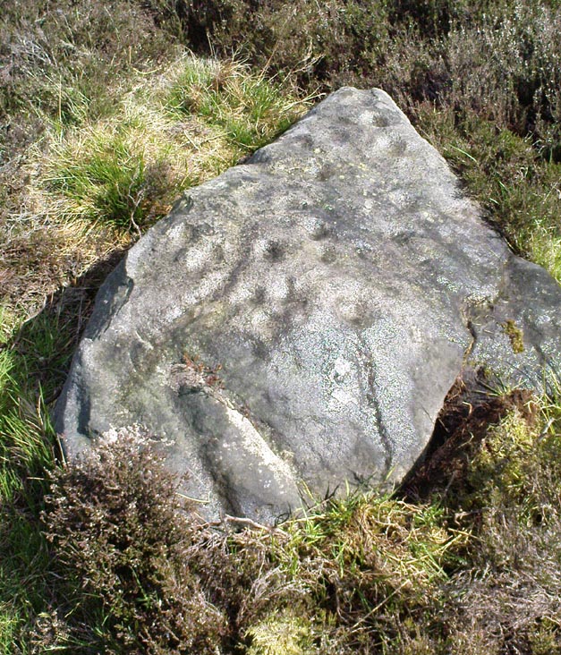
From Askwith village go up the Moor Lane and at the crossroads go straight across (Snowden Moor is to your left). Go down and along Snowden Carr Road until the road levels out and, watch carefully, about 500 yards on from the crossroads on your left you’ll see a small crag of rocks in the fields above. Stop and go through the gate walking up the field. At the top is a gate: go thru this and turn right, up the footpath for 100 yards, keeping your eyes peeled! You’re damn close!
Archaeology & History
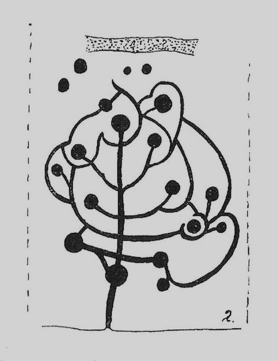
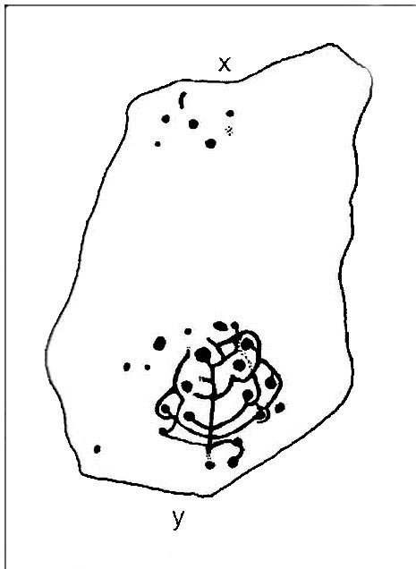
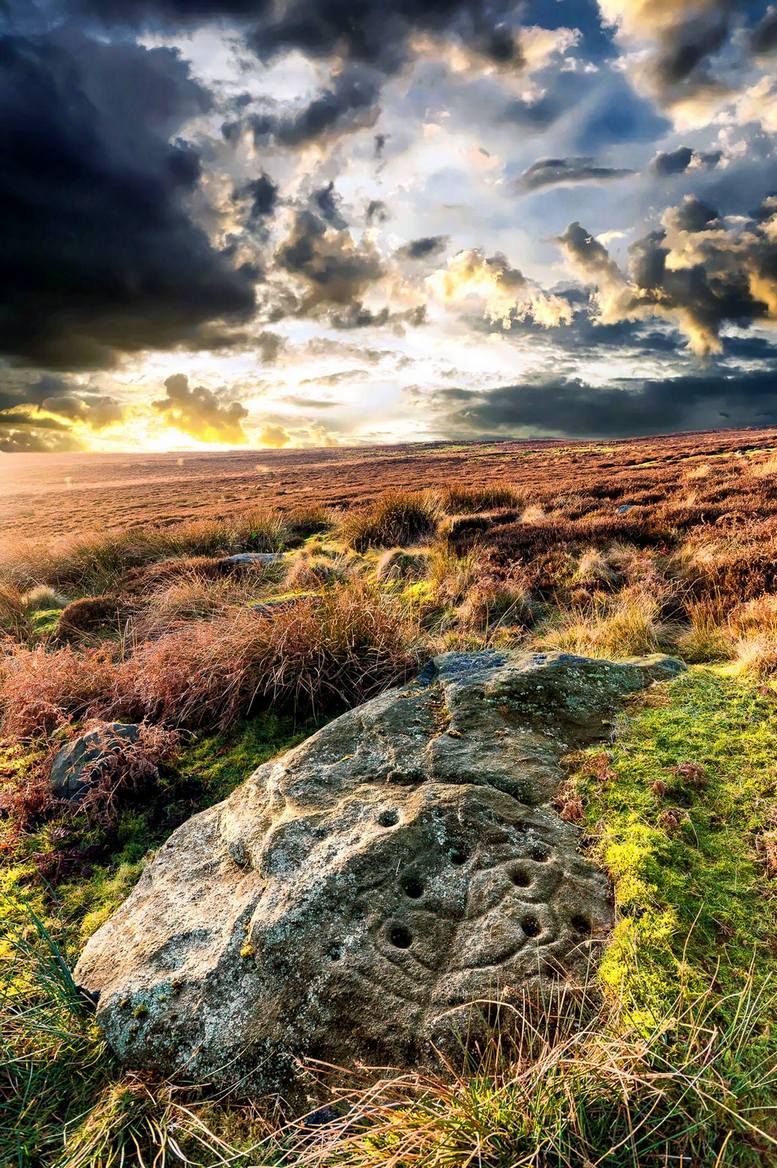
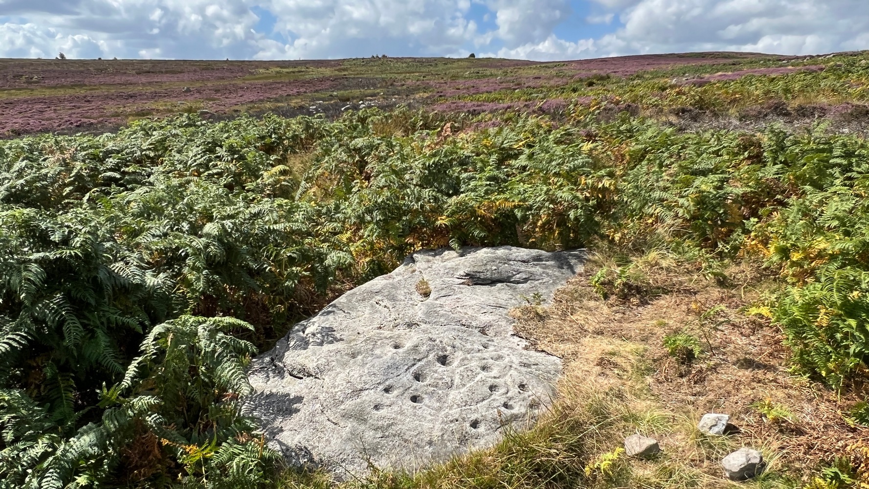
The most well-known and one of the more decorative of all the carvings in and around the Snowden Moor region is the Tree of Life Stone. In the 1930s, Eric Cowling first reported how, “this fine marking is the only one which appears to be known to the people of the district,” due in part to it being a site of local social activities (though nothing is said of this place in William Grainge’s [1895] survey). Cowling (1937) described the carving thus:
close-up of main featuresEric Cowling’s sketch
“This stone lies alongside the bridle path which skirts the southwest corner of the enclosed moorland above the hamlet of Low Snowden. A large flat rock surface at ground level has a number of cups joined together by a series of curved grooves, which in their turn are connected to a central straight groove. Immediately above the design, a broad groove has been cut across a raised central area as though to isolate the markings from several scattered cups which are to be found on the remaining surface.”
The modern surveyors Boughey & Vickerman (2003) tell us that this highly ornate stone comprises of,
“about 25 cups, with a group at the highest…end and a few isolated, but most in complex design with enclosing grooves suggesting a tree in fruit: hence the name ‘Tree of Life Rock.'”
The Tree of Life StoneBoughey & Vickerman’s sketch
The Coped Stone carving is just a few yards away and, on the slopes below here — as well as on the moor stretching above you — there is an excess of prehistoric remains: enclosures, hut circles, lengths of walling, cairns, other cup-and-ring stones — the vast majority of which has yet to be excavated in any formal sense (are any rich doods out there reading this who might wanna get things going…?). It appears that both the Coped Stone and the Tree of Life carving may have been linked by some ancient walling that appears to run between them.
Another possible variant on the Tree of Life Stone has recently been uncovered on the outskirts of Ilkley; but on this newly-discovered example we find the central ‘trunk’ of the ‘tree’ is a natural crack that runs up the middle of the rock. Up the ‘trunk’ are several short branches with cup-marks on either side, not unlike apples on a tree. Altogether there are at least 12 cups and one ring, with several curious lines, some of which seem geophysical in nature. After several visits to the site, it’s obvious that the ‘tree’ design is more obvious and there are additional faint carved sections on the stone which weren’t visible when it was discovered in heavy rain and poor light.
This is one of very few cup-and-ring stones with folklore attached. Cowling (1937; 1946) reported it to be site of early morning Beltane (May 1) gatherings. The title of the stone, the Tree of Life, was one he heard local people call this site, but “no reason is offered”, he said. About 100 yards below this we find a curious erectile, fertility image on the impressive carving 612, which (he says tenuously!) may (and that’s a dodgy “may”!) relate to the Beltane rites at the Tree of Life.
Tree of Life in situ
In more modern folklore, the old earth mysteries writer Guy Ragland Phillips (1976) suggested the Tree of Life Stone to be an important focal point along one helluva highly speculative ley line: running from the Irish Sea, across land and the Tree of Life stone, continuing way east until hitting the North Sea! If this old ley did have any validity (it doesn’t!), the Tree of Life’s carved partners east and west of here — the Coped Stone and carving no.597 — would have also been on the same line.
References:
Boughey, Keith & Vickerman, E.A., Prehistoric Rock Art of the West Riding, WYAS 2003.
Cowling, Eric T., “Cup and Ring Markings to the North of Otley,” in Yorkshire Archaeological Journal, part 131, 33:3, 1937.
Cowling, Eric T., Rombald’s Way: A Prehistory of Mid-Wharfedale, William Walker: Otley 1946.
Phillips, Guy Ragland, Brigantia — A Mysteriography, RKP: London 1976.
Acknowledgements: Many thanks to James Elkington and to Yorkshire Daz for use of their photos.
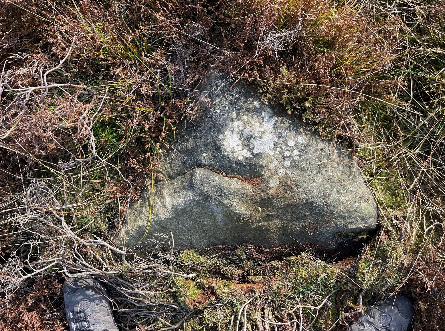
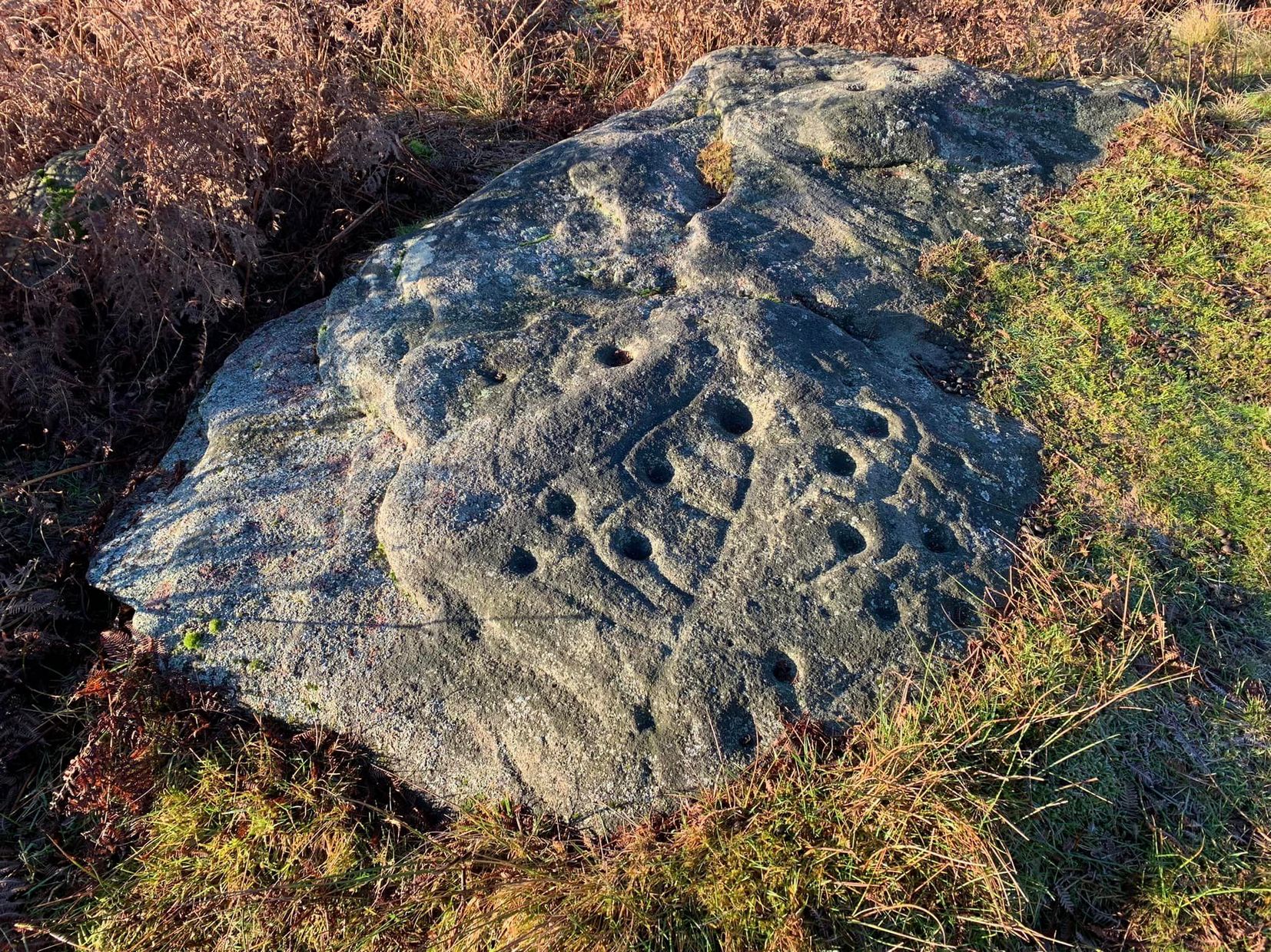
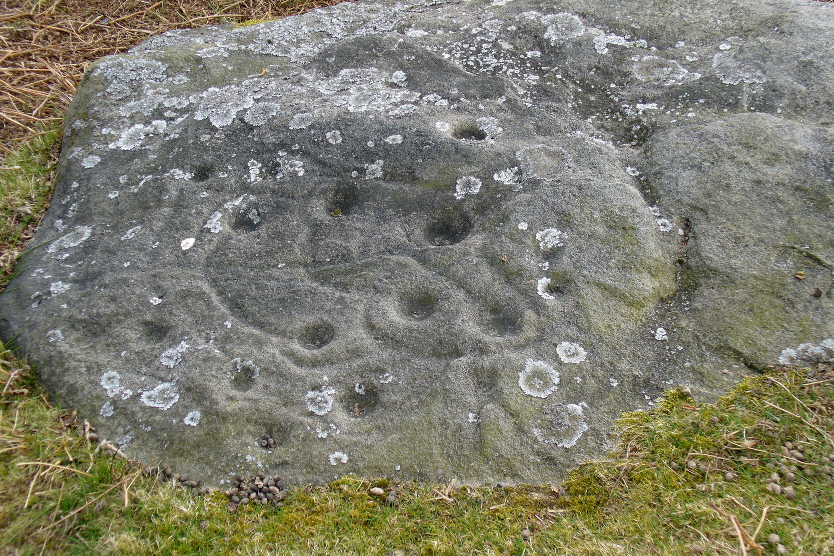
Take the same direction as for cup-and-ring carving 582 from the Askwith Moor Road parking spot, walk up the road (north) 300 yards until you see the disused quarry on the moor to your right. From here, head down onto the moor, straight down past the quarry for about 200 yards, angling slightly to your right. You’ll notice some overgrown scattered mass of rocky ‘lumps’ in the heather — a cairnfield no less! — go just below these and watch out for some rocks emerging from the heather. This carving (and its neighbours) is on one of ‘em!
Archaeology & History
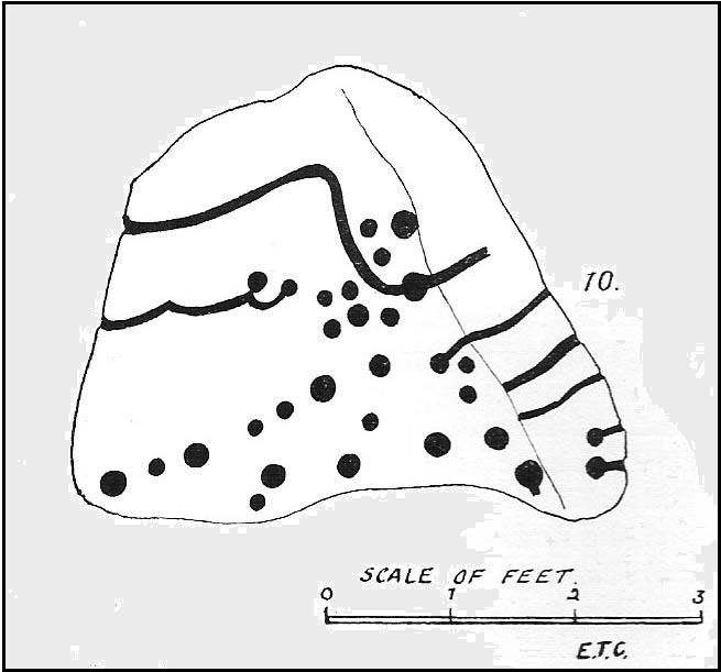
This impressive carving is one of a cluster of petroglyhs that are very close to each other, in the ruins of a cairn-field (though there’s some debate as to whether it’s medieval, prehistoric, or just quarry-spoil). Peppered with many cups on the upper surface of the stone, we also have carved lines and cup-marks along the east-facing edge of the rock aswell. I think it was Eric Cowling (1937) who was the first person to describe this stone (where he listed it as stone no.10 in his Otley survey), telling us that close to the Snowden Carr 582 carving,
“On the rise above No.9, is a cope-shaped boulder which is almost covered with cup markings and winding grooves. One broad groove winds from the ridge, rising from a cup, and is continued to the margin. Two cups are linked by a curve which is continued to the same edge. The eastern side of the stone is almost upright and bears two cups with grooves running to ground level.”
Due to the similarities in design on this stone and that of carving no.618 in Fewston valley bottom a half-mile away, Cowling thought that it likely that the same person did both carvings. Well….y’ never know!
References:
Boughey, Keith & Vickerman, E.A., Prehistoric Rock Art of the West Riding, WYAS 2003.
Cowling, Eric T., “Cup and Ring Markings to the North of Otley,” in Yorkshire Archaeological Journal, volume 33, 1937.
Cowling, Eric T., Rombald’s Way: A Prehistory of Mid-Wharfedale, William Walker: Otley 1946.


")